The Florida Legislature has just convened for the 2016 session, and news from the capitol is already announcing a sweeping water bill on the fast-track to passage. Supporters are quoted as saying it would provide increased protection for certain key water resources in the State such as springs and the Everglades; opponents are quoted as saying that while it doesn’t undo current protections, neither does it go far enough to assure sustainable protection of water resources for Florida’s future.
Thus it seems our legislators and lobbyists are celebrating something that’s a little better than what we’ve got now, but isn’t good enough to get the job done. That doesn’t sound very reassuring. We need a realistic blueprint for how Florida’s ever-expanding population and robust agricultural industry that produces our food can continue to use Florida’s water resources without using them up. The only way that’s going to happen is for citizens concerned about their grandchildren’s future in Florida to become the voices that legislators ignore at the peril of their political future.
So how do you know what to think, and what to say, about the state of water resources where you live – in the Panhandle? Do you understand their current status and vulnerabilities? Threats to their near-term viability? Prospects for their long-term sustainability, complicated as they are by projections of amplified climate variability?
“Panhandle Outdoors LIVE!” is stepping it up a notch for 2016, to help you get a handle on these “need to know” issues that affect future sustainability. University of Florida Extension’s acclaimed “Panhandle Outdoors LIVE!” mode of exploring signature water resources with knowledgeable guides is not going away; it’s being expanded into “water school” events in 2016. We are adding expert presentations and discussion to the on-water, on-trail immersion learning adventures you’ve come to love.
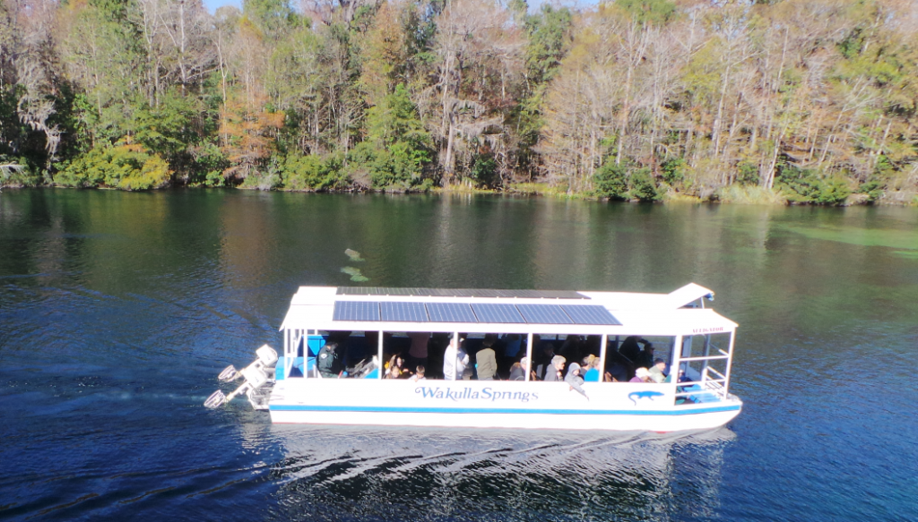
Daily river cruises on the Wakulla River are a great way to see manatees and other unique wildlife. Photo: L. Scott Jackson
This year we’ll study four Panhandle water resources of regional significance – the Wakulla Springshed, St. Joe Bay, the Econfina Watershed, and Weeks Bay. Two are freshwater streams and their watersheds; two are bays. Two are in the eastern Panhandle; two are in the west (one even in Alabama). Two are being offered in the spring, the other two in the fall.
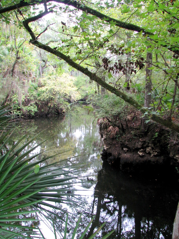
First up is the Panhandle Outdoors LIVE! – Wakulla Springshed School on March 1-2. It will base out of the magnificent “Old Florida” Wakulla Springs Lodge south of Tallahassee, and feature field trips to Leon Sinks Geological Area, Cherokee Sink and the Wakulla River – concluding with an optional paddle downriver from Wakulla Springs through a transition of ecosystems to historic Fort San Marcos de Apalachee, where the Wakulla joins the St. Marks River.
Next up, on April 4-5, is Panhandle Outdoors LIVE! – Weeks Bay Watershed School that will base out of the Episcopal Beckwith Camp and Retreat Center on Weeks Bay in Fairhope (Baldwin County) Alabama. This second watershed school will focus on the Weeks Bay National Estuarine Research Reserve, and feature a demonstration of oyster farming and a kayak paddle trip.
Those who have lived in the Panhandle area for many years will remember the days when our local bayous were places people water skied, kids learned to swim, and fishermen brought home plenty of speckled trout. But today we see little of this. Water quality within our bayous has declined to a point that the general public is concerned about recreation within them and most use them as access to larger bodies of water where they can enjoy water activities.
What Happened?
The mouth of Bayou Grande near Navy Point; a popular recreation location
Those who lived here when things were better say they first noticed problems when new roads and subdivisions were built in the 1950’s. Decline in water clarity was one of the first things they noticed. This was followed by a loss of submerged grasses, fish kills, and an increase in health advisories due to high levels of bacteria. These new subdivisions cleared much of the native vegetation in the neighborhoods and along the water front. The loss of vegetation and new roads allowed for more runoff to reach the bayous. Much of this runoff was in the form of leaf litter, twigs, animal waste, and maybe even carcasses of dead creatures. Once reaching the water these organics are broken down by bacteria into forms of nitrogen and phosphorus that can be utilized by aquatic plants and phytoplankton. This increase in plants will produce more oxygen, but they also consume oxygen in the evening. The high demand for oxygen in the evening can cause dissolved oxygen levels to decline to a point where aquatic life begins stressing; we now say the water is hypoxic. To add to the problem people began to have the desire for lawns of non-native grasses which require fertilizer and watering; thus increasing the nutrient load on the system and an increase in hypoxia. This eutrophication process was a major contributor to the fish kills that the bayous were experiencing.
In addition to nutrients, animal waste could be found in the stormwater. Animal waste can contain pathogensthat could be a serious risk to public health. Scientists monitor the concentration of these pathogenic bacteria by using a group of indicator bacteria called fecal coliformbacteria. High levels of these fecal coliforms indicate that a potential health risk could be present and the Escambia County Health Departmentwould issue a health advisory for that body of water. A study showed that the concentration of fecal coliforms increased in areas where coastal development increased, connecting them to stormwater problems.
So What Can We Do?
Marine Science Academy students from Washington High School measuring chlorophyll in Bayou Texar; photo: Ed Bauer
We will probably never be able to get the bayous back to the state they were in before the development boom of the mid-20th century but there are few things we can do.
First, the reason the nutrients and fecal coliforms increased was an increase in runoff. This increase was due to road construction and loss of vegetation. We cannot do much about the roads but we can rethink how we landscape our yards and waterfront property.
The Florida Friendly Yards Programis one that helps residents with selecting plants and landscaping features that require little or no fertilizer or water. This not only reduces the runoff but saves the homeowner money. Rain barrels and rain gardens are also methods that can both reduce water runoff and save money. For more information on this program you can contact Carrie Stevenson at the Escambia County ExtensionOffice; 850-475-5230 or ctsteven@ufl.edu.
Shoreline vegetation can be restored through the Living Shoreline Program. In this program the Florida Department of Environmental Protection works with the homeowner on designing a shoreline marsh and/or oyster reef project. Living Shorelines utilize plants that remove much of the nutrients found in runoff and oysters are known to filter 50 gallons of water per day, reducing turbidity typically caused by runoff. Not only do Living Shorelines reduce nutrient runoff, they also reduce erosion caused by wave energy. For more information on Living Shorelines contact Beth Fugate at beth.l.fugate@dep.state.fl.us.
Planting a Living Shoreline on Bayou Texar in Pensacola; photo: Florida Department of Environmental Protection
A third program that can help bring back the bayou is the Clean Marina / Vessel Program. This program is through the Florida Department of Environmental Protection. For more information contact Jeanne Williams at Jeanne.Williams@dep.state.fl.us.
We hope you will consider using one of these programs to help improve the water quality within our bayous. If you are interested in having a presentation on these programs contact Rick O’Connor at the Escambia County Extension Office; 850-475-5230 or roc1@ufl.edu.
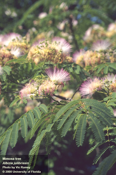
Mimosa Tree: When traveling down secluded roads, one always marvels at the beautiful fragrant puff-like flowers lining the right of way. Many people decide that they must have one for their yard. Unfortunately, obtaining one for landscaping purposes is a bad decision. This tree is a Mimosa, Albizia julibrissin, and is famous for the ability to thrive in disturbed areas and fix nitrogen. Mimosa was brought from China in the 1700 for use as an ornamental and remains popular today. Unfortunately it crowds out native vegetation by reducing sunlight and nutrients available and may clog small waterways with intense growth. What’s more, it produces numerous seed that can remain viable for many years and is capable of vegetative propagation. Fortunately, Mimosa may be controlled by a variety of techniques. Eliminating existing trees mechanically, such as with a power saw, will reduce future numbers substantially. Additionally, the application of a 25% solution of glyphosate or triclopyr herbicide to a freshly cut stump will prevent re-sprouting of cut trees. When applying herbicides, apply them only to the stump and not to surrounding areas. Remember to make the application within one minute of cutting the tree. Enjoy your invasive removal!
For more information, contact the author Matt Orwat, Horticulture Extension Agent 850-638-6180.
Video courtesy of UF/IFAS Center for Aquatic and Invasive Plants
Photo Courtesy of Universtiy of Florida
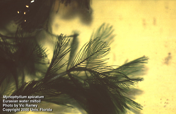
Eurasian Water Milfoil:Eurasian water milfoil is a submerged aquatic plant that can be found in northwest Florida in lakes, rivers, and coastal marshes. Water milfoil forms a dense mat of vegetation that can block sunlight and habitat for native plants. These mats can increase water temperatures and interfere with boat traffic, fish habitat, and native aquatic plant species. Eurasian milfoil was first documented in Florida in 1964. It was reportedly planted by aquarium plant dealers. It is still used today in the aquarium industry and obtained through suppliers and through internet sales. This plant is listed as a category II on the Florida Exotic Species Pest Plant Council List, which means it has the potential to overtake native submerged plant communities. The spread of Eurasian milfoil can be caused by the breaking of stems and roots, which can be carried by boats, engines and trailers to other lakes and coastal marshes. To help prevent spread of Eurasian water milfoil to Florida’s waters, always clean off your boat, motor and trailer at the ramp to avoid transporting vegetative stems to other areas. In addition, never release or dispose of aquarium plants or animals into local waterways.
For more information, contact the author Chris Verlinde, Marine Science Agent 850-623-3868.
No matter our distance from a lake, wetland, river, or coastline, we all live within the boundaries of a watershed – photo by Judy Ludlow
No matter our distance from a lake, wetland, river, or coastline, we all live within the boundaries of a watershed. In fact, all land on earth is part of a watershed and all habitats exist within a watershed boundary. The size of watersheds can vary from a few square feet to millions of acres. It is important to realize our location is always within a watershed. All domestic, agricultural, horticultural, or industrial activities that occur in a specific watershed will impact surrounding water quality and quantity.
The United States Environmental Protection Agency defines a watershed as “an area of land where all of the water that is under it or drains off of it goes to a common waterway, such as a stream, lake, estuary, wetland, aquifer, or even the ocean.” Think of a watershed as a bowl or basin formed by the elevation of surrounding terrain. Gravity moves rainwater, surface water, and groundwater down the basin to its lowest point ending in a body of water.
Being aware of your actions within the watershed is important to the long term water quality and quantity of your favorite panhandle Florida lake, river, or spring run – photo by Judy Ludlow
With that description in mind (water moving to the lowest point), think about the daily activities within your watershed. Watersheds contain houses, cars, businesses, natural areas, timber lands, agriculture, gardens, golf courses, shopping malls, pavement, septic systems, factories etc. So no matter where we are within our watershed, whatever falls to the ground (wash water, chemicals, fertilizers, fuels, oils, wastes, etc.) within that watershed will flow “downhill” to the water system that drains it. You may think the accidentally spilled motor oil may never reach the nearest lake, but it will impact the surface water and/or ground water as it moves downhill through the watershed. You may also think one isolated spill is insignificant. Keep in mind however; the more densely populated a watershed is, the greater the frequency and volume of impacts to surface and ground water will be.
Whether you are a business or individual, becoming aware of your watershed “address” is a novel way to view your essential connection to your water resources. Becoming aware, also, of your actions within the watershed, is important to the long term water quality and quantity of your favorite Panhandle lake, river, or spring run.
For more information about locating your watershed “address” and about watershed management please see the following resources.
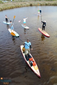
It is human nature to explore. We are a curious species, yearning from birth to stimulate our senses of sight, smell, touch…from an infant’s grab at a colorful toy to an astronaut setting foot on the moon, we thrive on new adventures and understanding. A legend of the Age of Exploration, Spanish explorer Ponce de Leon set foot on Florida’s coast in 1513, and 500 years later, another water-based expedition is taking place. This time, the explorer sets out not to conquer, but to celebrate the unique ecology and history of Florida. On January 1, University of Florida graduate Justin Riney, founder of a nonprofit advocacy group called Mother Ocean, launched a 365 day standup paddleboard journey around the state. Several standup paddleboarding enthusiasts (myself included) joined him at Big Lagoon State Park in Pensacola to begin the 1,515 mile Florida Circumnavigational Saltwater Paddling Trail, which hugs the coastline south through the Keys and back north to Jacksonville.
The author (top right) participates in the launch of Expedition Florida 500 at Big Lagoon State Park on January 1. Photo Credit: Jackson Berger
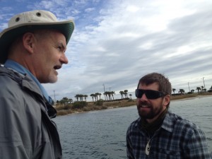
Justin plans to paddle for at least 10 miles a day, carrying all of his gear on his board and camping at beaches in each community. The goal of the trip is not only to help celebrate the 500th anniversary, but he’s partnered with the Florida Department of Environmental Protection, the University of Florida, and several watersports companies to promote the expedition and highlight conservation of the springs, rivers, estuaries and beaches around our state. He hopes the journey will inspire people to explore and protect our invaluable water resources, and encourages locals to join him at each location to paddle and share knowledge about their waterways. Along the route, he has scheduled almost three weeks to take daylong tours in areas of particular ecological and historical significance. Today several of us joined him on a trip through Pensacola Bay, where we discussed everything from the history of Fort Pickens, to the improvement of water quality in Bayou Chico, to the Appalachian origins of our sugar-white sands.
Captain Robert Turpin, Escambia County Marine Resources (left), discusses seagrass preservation in Little Sabine Bay with Justin Riney.
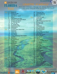
In several communities, he plans to lead coastal cleanups. Justin will be paddling from Pensacola through Gulf Breeze tomorrow and to south Okaloosa and Walton counties through January 11. From there, he will continue along the coast, and on to Bay and Franklin counties between the 15-26 of this month. The detailed schedule below outlines his route from the Panhandle and beyond.
Coastal Schedule for Expedition Florida 500
You can follow Justin’s experiences at Expedition Florida 500 on Facebook to see updates, photos, and information about where he will be next. If you’re a standup paddleboarder, kayaker, or just interested in the project, contact him through the page and take the time to be part of this historic journey. And for those of you who live further inland, after reaching Jacksonville on July 4, he plans to paddle back through the state exploring inland waterways–rivers, springs, and lakes–so there’s a good chance Expedition Florida will come to your community this year as well!