Miami is ground zero for invasive species in this state. But the Florida panhandle is no stranger to them. Where they are dealing with Burmese pythons, melaleuca, and who knows how many different species of lizards – we deal with Chinese tallow, Japanese climbing fern, and lionfish. The state spends hundreds of thousands of dollars each year battling and managing these non-native problem species. By definition, invasive species cause environmental and/or economic problems, and those problems will only get worse if we do not spend the money to manage them. Those who work in invasive science and resource management know that the most effective way to manage these species is to detect them early and respond rapidly.
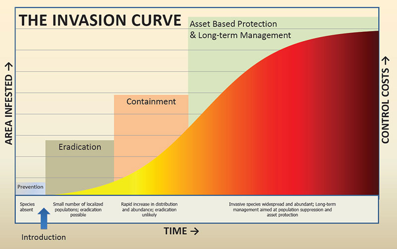
The Invasive Species Curve
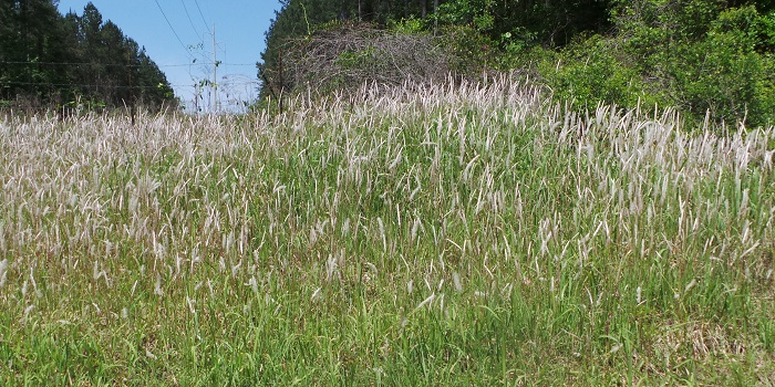
Invasive species have made their way to the coastal waters and dunes of the barrier islands in the Florida panhandle. Beach vitex, Brown anoles, and Chinese tallow are found on most. Recently on Perdido Key near Pensacola, we found a new one – cogongrass.
Cogongrass (Imperata cylindrica) was accidentally introduced to the Gulf coast via crates of satsumas entering the port of Mobile in 1912. It began to spread from there and has covered much of the upland areas of the southeastern U.S. It has created large problems within pasture lands, where livestock will not graze on it, and in pine forest where it has decreased plant and animal biodiversity as well as made prescribed burning a problem – it burns hot, hot enough to actually kill the trees. The impacts and management of this plant in that part of the panhandle has been known for a long time. The Department of Agriculture lists it as one of the most invasive and noxious weeds in the country.
Cogongrass seedheads are easily spotted in spring.
Photo credit: Mark Mauldin
Two years ago cogongrass was discovered growing around a swimming pool area at a condo on Perdido Key. To be considered an invasive species you must (a) be non-native to the area – cogongrass is certainly non-native to our barrier islands, (b) have been introduced by humans (accidentally or intentionally) – strike two, we THINK it was introduced by mowers. This is a common method of spreading cogongrass, mowing an area where it exists, then moving those mowers to new locations without cleaning the equipment. We do not know this is how it got to the island, but the probability is high. Third, it has to be causing an environmental and/or economic problem. It certainly is north of the I-10, but it is not known what issue it may cause on our barrier islands. Could it negatively impact protected beach mice and nesting sea turtle habitat? Could alter the integrity of dunes to reduce their ability to hold sand and protect properties. Could it overtake dune plants lowering both plant and animal diversity thus altering the ecology of the barrier island itself? We do not know. What we do know is that if we want to eradicate it, we need to detect it early and respond rapidly.
According to EDDMapS.org – there are 75 records of cogongrass on the barrier islands, and coastal beaches of the Florida panhandle. This is most likely under reported. So, step one would be to conduct surveys along your islands and beaches. Florida Sea Grant and Escambia County of Marine Resources are doing just that. EDDMaps reports five records on Perdido Key and four at Ft. Pickens. It most likely there is more. A survey of the northeast area of Pensacola Beach (from Casino Beach east and north of Via De Luna Drive) has found two verified records and two unverified (they are on private property, and we cannot approach to verify). Surveys of both islands continue.
The best time to remove/treat cogongrass is in the fall. The key to controlling this plant is destroying the extensive rhizome system. In the upland regions, simple disking has been shown to be effective if you dig during the dry season, when the rhizomes can dry out, and if you disk deep enough to get all of the rhizomes. Though the rhizomes can be found as deep as four feet, most are within six inches and at least a six-inch disking is recommended. Depending on the property, this may not be an option on our barrier islands. But if you have a small patch in your yard, you might be able to dig much of it up.
Chemical treatments have had some success. Prometon (Pramitol), tebuthurion (Spike), and imazapyr have all had some success along roadsides and in ditches north of I-10. However, the strength of these chemicals will impede new growth, or plantings of new plants, for up to six months. There are plants that are protected on our islands and on Perdido Key any altering of beach mouse habitat is illegal. We certainly do not want to kill plants that are holding our dunes. If you feel chemical treatment may be needed for your property, contact the county extension office for advice.
Most recommend a mixture of burning, disking, and chemical treatment. But again, this is not realistic for barrier islands. Any mechanical removal should be conducted in the summer to remove thatch and all older and dead cogongrass. As new shoots emerge in late summer and early fall herbicides can then be used to kill the young plants. Studies and practice have found complete eradication is difficult. It is also recommended not to attempt any management while in seed (in spring). Tractors, mowers, etc. can collect the seeds and, when the mowers are moved to new locations, spread the problem. If all mowing/disking equipment can be cleaned after treatment – this is highly recommended.
Step one would be to determine if you have cogongrass on your property, then seek advice on how to best manage it. For more information on this species, contact your local extension office.
The Gulf of Mexico Sea Grant Science Outreach Team is proud to announce four new outreach items that are applicable throughout the US and showcases marine microplastics and homeowners’ insurance:
Marine Microplastics Primer for Extension Professionals – This publication is intended to serve as a guide for extension professionals to aid in answering questions about microplastics that they have encountered or may encounter in the future. The publication can be accessed at https://gulfseagrant.org/wp-content/uploads/2023/08/MASGP-23-051.pdf.
Property Insurance Basics – Confused about homeowners’ insurance and what it covers or know people who are? The outreach team has created a publication to share basic information about insurance to help property owners make informed decisions about the amounts and types of protection for their homes. Access to the publication can be found https://gulfseagrant.org/wp-content/uploads/2023/08/MASGP-23-015.pdf.
What is Risk Rating 2.0 and how will it affect my flood insurance?–FEMA has updated their risk rating approach through a new pricing method. This change is the biggest change to the way flood insurance premiums are calculated since 1968. Want to learn more about this new system and how it will affect your flood insurance? Click https://gulfseagrant.org/wp-content/uploads/2023/08/What-is-Risk-Rating-2.0.pdf to access our publication.
I attended a meeting recently where one of the participants stated – “We have been looking at a lot of water quality parameters within our bay in recent years, and plan to look at more, but has anyone been looking at temperature?”
What he was referring to was that the focus of most monitoring projects has been nutrients, dissolved oxygen, etc. But most agencies and universities who have been conducting long term monitoring in our bays are collecting temperature data as well. His question was not whether they have or not but has anyone looked at this long-term temperature data to see trends.
I know from some of the citizen science monitoring I have been involved with that temperature is collected but (anecdotally) does not vary much. It is like pH, we collect it, it is there, but does change drastically (anecdotally) over time. However, it has been a very hot year. This “heat dome” that has been sitting over the Midwest and southeast this summer has set records all across the region. Someone monitoring water temperature in East Bay recently reported surface water temperature at 96°F (36°C). Many have stated that swimming in our waters at the moment feels like swimming in bath water. It’s not just warm in your yard, it is warm in the bay. And this brings up the question of thermal tolerance of estuarine species.
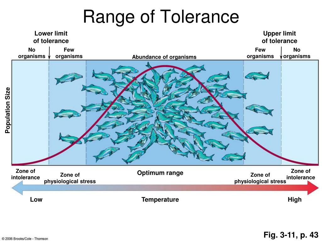
All creatures have a temperature tolerance range. They resemble a bell curve where you have the thermal minimum at one end, the thermal maximum at the other, and the “preferred” temperatures near the top of the bell curve (see image below). Many creatures have a large tolerance for temperature shifts (their bell curves extend over a larger temperature range). You find such creatures in the temperate latitudes where temperature differences between summer and winter are larger. Others have a lower tolerance, such as those who are restricted to polar or tropical latitudes. Within an estuary you can find creatures with varying thermal tolerances. Some have a larger tolerance than others. Ectothermic (cold-blooded) creatures often have a wider range of temperatures they can survive at than endothermic (warm-blooded) ones. Homotherms (creatures who maintain their body temperature near a fixed point – such as humans 98.6°F/37°C) expend a lot of energy to do this. When environmental temperatures rise and fall, they have to expend more to maintain it at their fixed temperatures.
Image provide by Research Gate.
It is also true that most creatures prefer to exist near their thermal maximum. In other words, the bell curve is sort of skewed towards the warmer end of their range. But what is their thermal maximum? What happens when they reach it? How hot can they go?
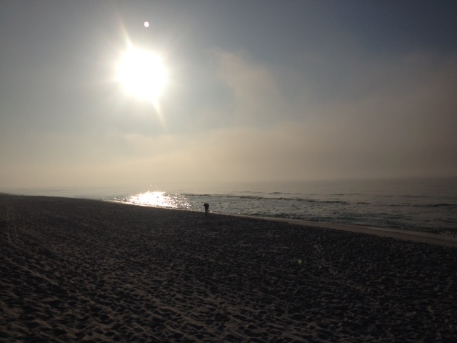
Local waters are warmer this year.
Photo: Rick O’Connor
The studies I reviewed suggested that the thermal maximum is dependent on other environmental factors such as salinity and dissolved oxygen. In most cases, the higher the salinity, the higher the thermal maximum was. I looked at studies for the eastern oyster (Crassostrea virgincia), the brown shrimp (Farfantepenaeus aztectus), the blue crab (Callinectes sapidus), the Spot Croaker (Leiostomus xanthurus), and the pinfish (Lagodon rhomboides). The oyster, shrimp, and blue crab support important commercial fishery. The spot croaker is a dominant fish species in the upper estuary where the pinfish is a dominant species in the lower sections. These studies all suggested that again, depending on salinity, dissolved oxygen, pressure, and rate of temperature increase, the thermal maximum could happen as low as 30°C (86°F) and as high as 40°C (104°F), with many having a thermal maximum between 35-40°C.
At these temperatures proteins begin to denature and biological systems begin to shut down. Most of the studies determined the endpoint at “loss of equilibrium” and not actually death. Our estuaries can certainly reach these temperatures in the summer. Again, one recent reading in East Bay (within the Pensacola Bay system) was 96°F (36°C).
So, what do these creatures do when such temperatures are reached?
The most obvious response is to move, find cooler water. These are often found in deeper portions of the bay below the thermocline (a point in the water column where water temperatures significantly change – usually decreasing with depth). However, many sections of our estuaries are shallow and deep water cannot be found. In these cases, they may move great distances to seek deeper water areas, or even move to the Gulf of Mexico. In some cases – like with oysters – they cannot move, and large die-offs can occur. Other responses include lower metabolic rates and decline in reproduction.
We know that throughout history, there have been warmer summers than others and heat waves have happened. In each case, depending on other environmental factors, estuarine creatures have adapted, and some members have survived, to keep their populations going.
We know that large scale die-offs have occurred in the past and the tougher species have continued on.
We also know that the planet is warming, and it would be interesting to look at how the water temperatures have changed over the last few decades. Are they increasing? Are they reaching the thermal maximums of the creatures within our bay? How will these creatures respond to this?
You might say this is a strange title – “meet the barnacle” – because everyone knows what a barnacle is… or do they?
As a marine science instructor, I gave my students what is called a lab practical. This is a test where you move around the room and answer questions about different creatures preserved in jars. Almost every time that got to the barnacle they were stumped. I mean they knew it was a barnacle but what kind of animal is it? What phylum is it in?
Going through a thought process they would more often than not choose that it was a mollusk. This makes perfect sense because of the calcium carbonate shell it produces. As a matter of fact, science thought it was a mollusk until 1830 when the larval stage was discovered, and they knew they were dealing with something different. It is not a mollusk. So… what IS it? Let’s meet the barnacle…
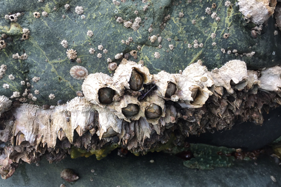
Barnacles along the seashore is a common site for many.
Photo: NOAA
The barnacle is actually an arthropod. Yep… the same group as crabs and shrimp, insects and spiders. Weird right…
But that is because the creature down within that calcium carbonate shell is more like a tiny shrimp than an oyster. It is in the class Cirripedia within the subphylum Crustacea. It is the only animal in this class and the only sessile (non-motile) crustacean.
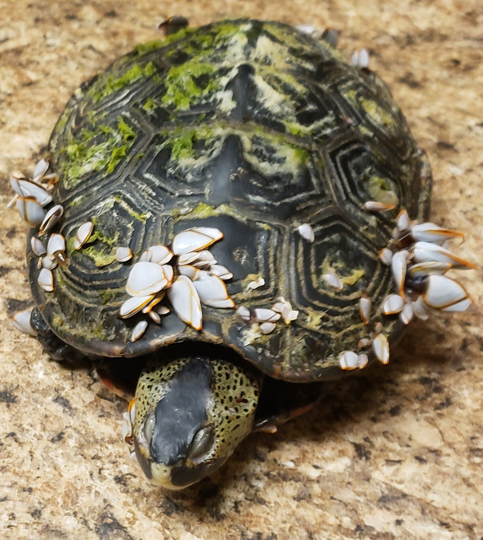
Barnacles are exclusively marine. This has been helpful when conducting surveys for terrapins or assessing locations for living shorelines – if you see barnacles growing on rocks, shells, or pilings, it is salty enough. There are over 900 species described and they live independently from each other attached to seawalls, rocks, pilings, boats, even turtle shells. Louis Agassiz described the barnacle as “nothing more than a little shrimplike creature, standing on its head in a limestone house kicking food into its mouth.”
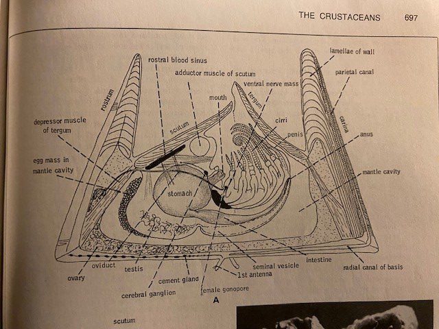
This image from a textbook shows the internal structure of a barnacle. Notice the shrimplike animal on its back with extendable appendages (cirri) for feeding.
Image: Robert Barnes Invertebrate Zoology.
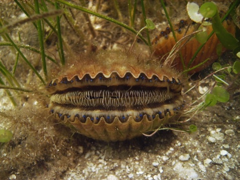
The planktonic barnacle larva settles to the bottom and attaches to a hard substrate using a cement produced from a gland near the base of their first set of antenna (crustaceans, unlike insects and spiders, have two sets of antenna). It is usually head down/tail up and begins to secrete limestone plates forming the well known “shell” of the animal. Some barnacles produce a long stalk near the head end (called the peduncle) which holds the adhesive gland and it is the peduncle that attaches to the hard substrate, not the head directly. The goose neck barnacle is an example of this. We find them most often in the wrack along the Gulf side of our beaches attached to driftwood or marine debris.
Lucky was found in the Gulf of Mexico. He had been there long enough for these goose neck barnacles to attach and grow.
Photo: Bob Blais
The “shell” of the barnacle is a series of calcium carbonate plates they secrete. These plates overlap and are connected by either a membrane or interlocking “teeth”. The body lies 90° from the point of attachment on its back.
There are six pairs of “legs” which are very long and are extended out of the “doors” of the shell and make a sweeping motion to collect planktonic food in the water column. They are most abundant in the intertidal areas were there are rocks, seawalls, or pilings.
Most species are hermaphroditic (possessing both sperm and egg) but cross fertilization is generally the rule. Barnacles signal whether they are acting males or females via pheromones and fertilization occurs internally, the gametes are not discharged into the water column as in some mollusks and corals. The developing eggs brood internally as well. Our local barnacle (Balanus) breeds in the fall and the larva (nauplius) are released into the water column in the spring by the tens of thousands. The larva goes through a series of metamorphic changes until it settles on a hard substrate and becomes the adult we know. They usually settle in dense groups in order to enhance internal fertilization for the next generation. Those who survive the early stages of life will live between two and six years.
So, there you go… this is what a barnacle is… a shrimplike crustacean who is attached to the bottom by its head, secretes a fortress of calcium carbonate plates around itself, and feeds on plankton with its long extending legs. A pretty cool creature.
Reference
Barnes, R.D. 1980. Invertebrate Zoology. Saunders College Publishing. Philadelphia PA. pp. 1089.
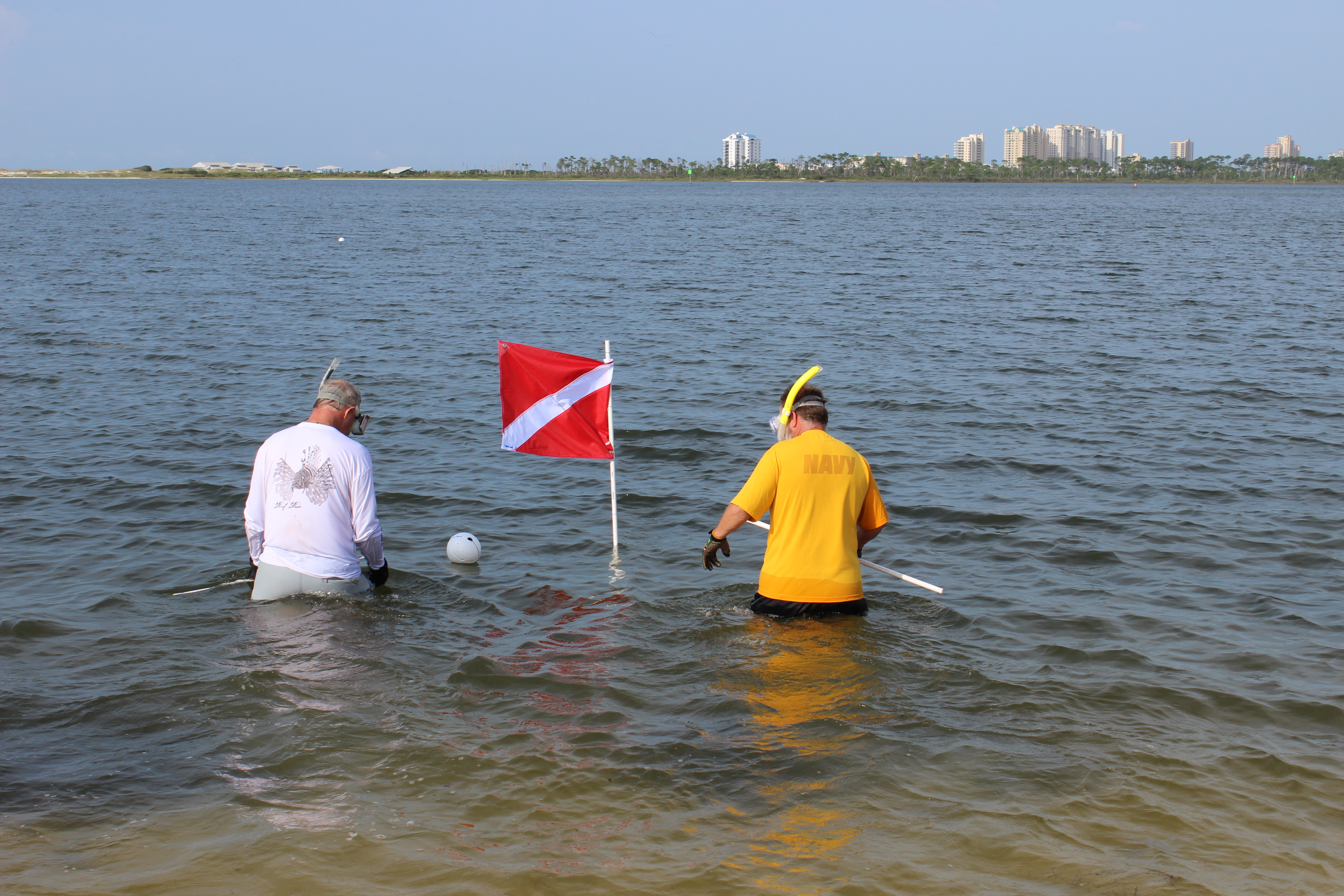
As I write this, we are in the middle of our 2023 Scallop Search, an event we do each year to assess whether the scallops in Pensacola Bay are trying to make a comeback on their own. Each year I am amazed at how popular this little mollusk is. On the day I am writing, I will be working with a marine science class from the University of Southern Mississippi driving over from Ocean Springs. This past weekend I worked with two families who trailered their boat from Enterprise Alabama to participate. Those on the eastern end of the panhandle are well aware of the popularity of this creature. Folks from all over the southeast travel there to go scalloping. Many of the locals in my area, when I am training them how to do a scallop search, tell me that they head east and go scalloping every year. Some even have condos for that week and it is a large part of their annual vacation plans. And many of the locals here would love to see them return to Pensacola Bay.
This is a creature that draws a lot of attention. But most know very little about it. They know it has small eyes and can swim – actually… I have recently found that not everyone knows they can swim. We know they like grassbeds and they can be harvested in the summer. They may have done this long enough to know the prime spots within the grassbeds to search for them – their “sweet spots”. But not much more.
So… let’s meet the bay scallop.
Volunteers conducting the great scallop search.
Photo: Molly O’Connor
Its scientific name is Argopecten irradians. It is a mollusk in the class Bivalvia and the family Pectinidae. There are numerous species, and the group is found all over the world. The greatest variety of them are from the Indo-Pacific region, and in each case, they are a popular seafood. Most can swim, though erratically – they are not Michael Phelps – and they use this ability to avoid predators such as starfish, which they can see with the set of simple eyes.
There are five subspecies of A. irradians. A. irradians irradians, known as the bay scallop, or Atlantic Bay scallop (and from here is just “the scallop”) is our local variety. It is found from Cape Cod to the Gulf of Mexico. They begin life as a microscopic egg produced during the mass spawning of the hermaphroditic parents (hermaphroditic meaning each parent can produce sperm and egg). The timing of the release of gametes is triggered by warming water and usually occurs in the late summer/early fall. This early egg stage sinks to the bottom where it remains for a few weeks before hatching.
The hatched larva remain microscopic, are transparent, resemble the parents, and are called spat. The spat become part of the plankton in local estuaries but eventually return to the grass in what is called “spatfall” where they attached to the seagrasses using byssal threads. They continue to grow, eventually release from the grass, and become the scallops we all know and love. Many species of scallops can live over 20 years, but our local one only lives for one.
As most know, adult scallops have two shells (bivalves) connected at the hinge on the dorsal side of the animal. Though they do add weight to the shell, a disadvantage for a swimmer, the “ribs” provide a sturdier shell. The two shells are connected by a single, large adductor muscle, which is used to open and close the valves during swimming. It is this adductor muscle we eat when consuming scallops.
Like all bivalves, scallops are filter feeders but unlike most bivalves they lack siphons to draw water in and out of the digestive tract. Rather they lie with their valves slightly gaped and allow water to pass over them. Plankton is collected by a mucous layer and then moved to the gut by cilia (small hair-like structures) where it is digested.
Bay Scallop.
Photo: FWC
Like all bivalves, scallops lack a brain as we know it but rather function using a series of ganglia (groups of nerve cells) connected to a nerve ring. These ganglia can control movement of the muscle, gills, eyes, and are connected to a statocyst, which tells the scallop how it is oriented in the water column.
There are numerous eyes aligned along the edge of each valve that can detect movement and shadows. It is believed that they use their eyes to detect potential predators and possibly initiate the swimming behavior they are famous for.
Living only one year, and reaching maximum size in late summer during spawning, scallop harvesting is regulated to that time of year in Florida. Once common from Pensacola to Miami, they are now only found in large numbers in the Big Bend region. Due to the loss of scallops in other areas, many visit the Big Bend each year to go scalloping, putting heavy harvest pressure on those stocks. There have been efforts to try and enhance the existing populations as well as restore historic ones. Here in Pensacola Bay, Florida Sea Grant works with volunteers to monitor the water quality and seagrasses, as well as assess how the few existing scallops are doing.
For more information on panhandle scallops, contact your local Sea Grant Agent at the county extension office.
Welcome to Red Snapper Season 2023! The season began June 1, 2023 at 12:01am for “For Hire” vessels fishing in federal waters and continues through August 25, 2023.
For Florida recreational anglers in state waters, the season started a few days later on June 16. While the summer season ends on July 31, 2023, fishing enthusiasts can look forward to 3-day fishing weekends in Florida State waters later in October and November 2023. This means there are still additional days of red snapper fishing opportunities in 2023, giving you ample time to plan exciting fishing adventures.
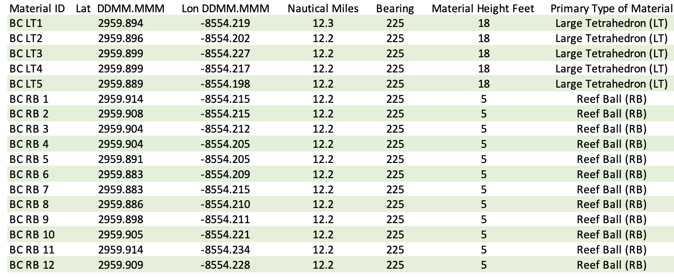
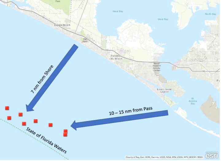
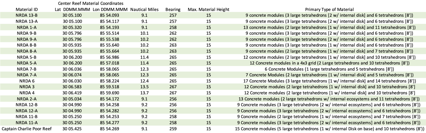
Here, we present Bay County’s recent artificial reefs, which serve as prime fishing locations for this year’s seasons. This select collection includes three distinct areas: east (State), south (Federal), and west (State). These sites have had the opportunity to grow and mature, with over 290 reef modules deployed between May 2019 and December 2020.
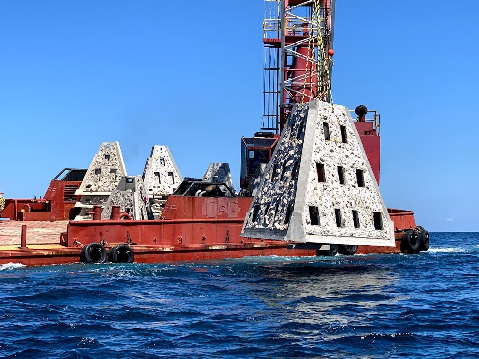
East Location – Sherman Site
Walter Marine deploys one of nine super reefs deployed in Bay County’s NRDA Phase I project located approximately 12 nautical miles southeast of the St. Andrew Pass. Each massive super reef weighs over 36,000 lbs and is 15 ft tall. Multiple modules deployed in tandem provides equivalent tonnage and structure similar to a medium to large sized scuttled vessel. Photo by Bob Cox, Mexico Beach Artificial Reef Association.
This project was completed in May 2019 in partnership with the Mexico Beach Artificial Reef Association, Florida Fish and Wildlife Conservation Commission, and Florida Department of Environmental Protection. The deployment site in the Sherman Artificial Reef Permit Area is approximately 12 nm southeast of St. Andrew Bay Pass at a depth of approximately 80 feet. A total of twenty-five modules were deployed, including nine 18-ton reefs and sixteen 3-ton reefs.
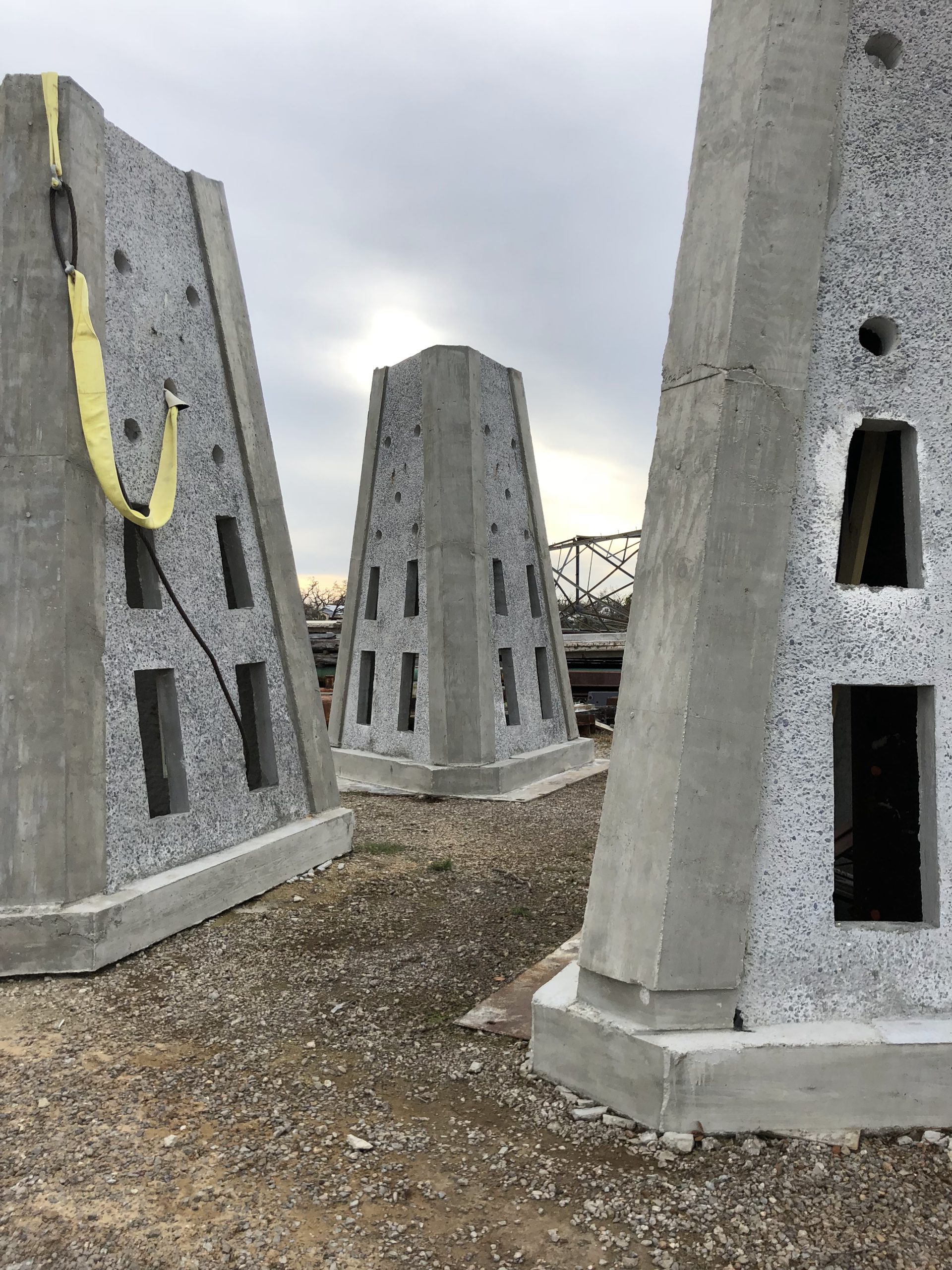
South Location – Large Area Artificial Reef Site (LAARS) A
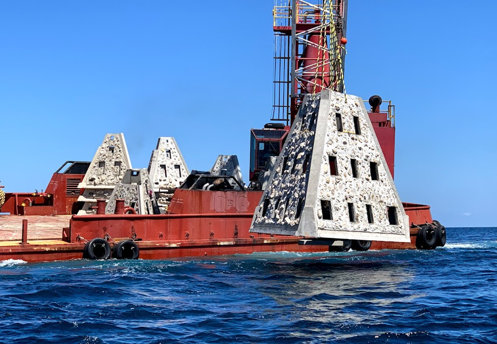
Large 45,000 lbs. concrete modules staged for deployment. These were placed by HG Harders and Son in July of 2019.
This project was completed in July 2019 in partnership with the Bay County Artificial Reef Association and the Florida Fish and Wildlife Commission. The deployment site in LAARS A is approximately 12 nm south of the pass, with reef modules located around the center of the permitted area. The reefs are situated in about 105 feet of water. There are seventeen reef modules, including five 22-ton reefs with a height of 18 feet and twelve 2.5-ton reefs with a height of 5 feet.
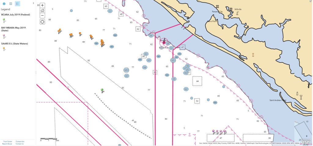
West Location – SAARS E – L
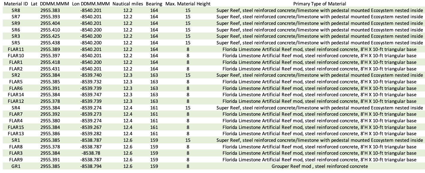
This area has the largest number of reef modules and permit sites. It includes 154 small pyramids that are 8 ft tall and weigh about 10 tons. There are also 26 large pyramids that are 18 ft tall and weigh about 18 tons. Additionally, 25 concrete disk reefs, weighing about 3 tons each, were deployed nested inside select Super Reefs, adding to the complexity and diversity of the reefs. In total, approximately 980 tons of engineered concrete artificial reef material were placed in 8 permitted areas. These deployments were completed in December 2020 with the support of the Mexico Beach Artificial Reef Association.
Bay County’s NRDA Phase II deployment in Small Area Artificial Reef Sites (SAARS) E – L are located 11 – 15 nautical miles (nm) southwest of St Andrew Bay Pass in Florida state waters. (Source ArcGIS mapping software).
This monitoring dive was conducted by FWC in January 2021, shortly after the reefs were deployed. You can move the 360 deg video image to experience what the divers see and observe.
Below is an overview map of these three prime snapper sites!
Wishing everyone great fishing days on the water with family and friends!
Chantille Weber, Coastal Resource Coordinator, UF/IFAS Extension Bay County
L. Scott Jackson, Bay County Extension Director, UF/IFAS Extension Bay County and Florida Sea Grant
An Equal Opportunity Institution. UF/IFAS Extension, University of Florida, Institute of Food and Agricultural Sciences, Andra Johnson, Dean for UF/IFAS Extension. Single copies of UF/IFAS Extension publications (excluding 4-H and youth publications) are available free to Florida residents from county UF/IFAS Extension offices.