
Rainfall
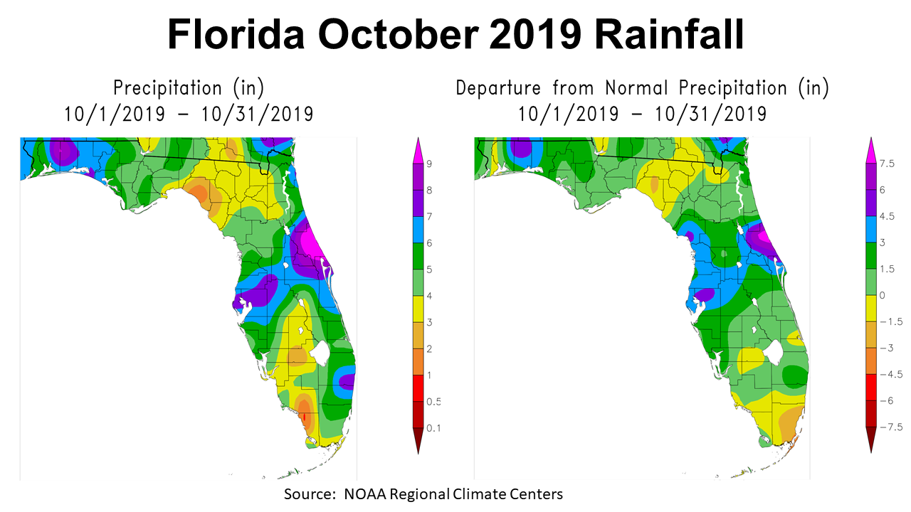
Like the rest of 2019, October was not a typical month. In contrast to the previous months, October was wetter than normal. Historically, October is the driest month of the year, but not in 2019. October rainfall ranged from 3-8″ across the Panhandle, as seen in the map to the left above. The map on the right shows how this rainfall compared to historic average. Only the sections of Florida in yellow or tan falling below normal.
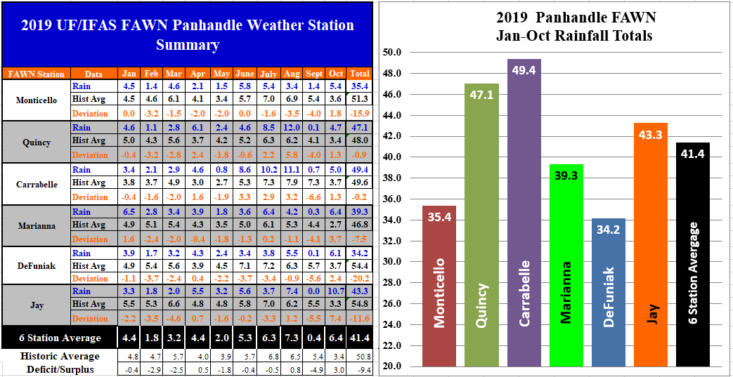
The six Florida Automated Weather Network (FAWN) weather stations in the Panhandle showed the variation in rainfall across the region. The wettest location was in Jay with 10.7″ and the driest location was in Quincy with 4.7″ for the month. All six stations recorded more than historic average for the first time in 2019. The six station average was 6.4″, which was 3″ above average.
For the year the wettest location in 2019 has been in Carrabelle, with 49.4″ thus far. Contrast that total to only 34.2″ recorded in DeFuniak. The six-station average total through October was 41.4″, which was 9.4″ below average. Through 10 months, all six stations have recorded less than historic average rainfall ranging in deviation from -0.2″ in Carrabelle to -20.2″ in DeFuniak.
–
Drought
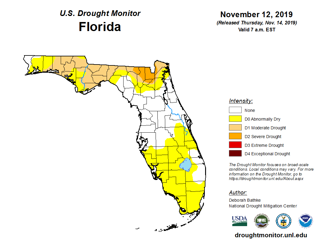
The most recent drought monitor, shows that even with above average rainfall in October, much of the Panhandle remains in some level of drought. October rainfall did bring improvement, but the drought is far from over.
–
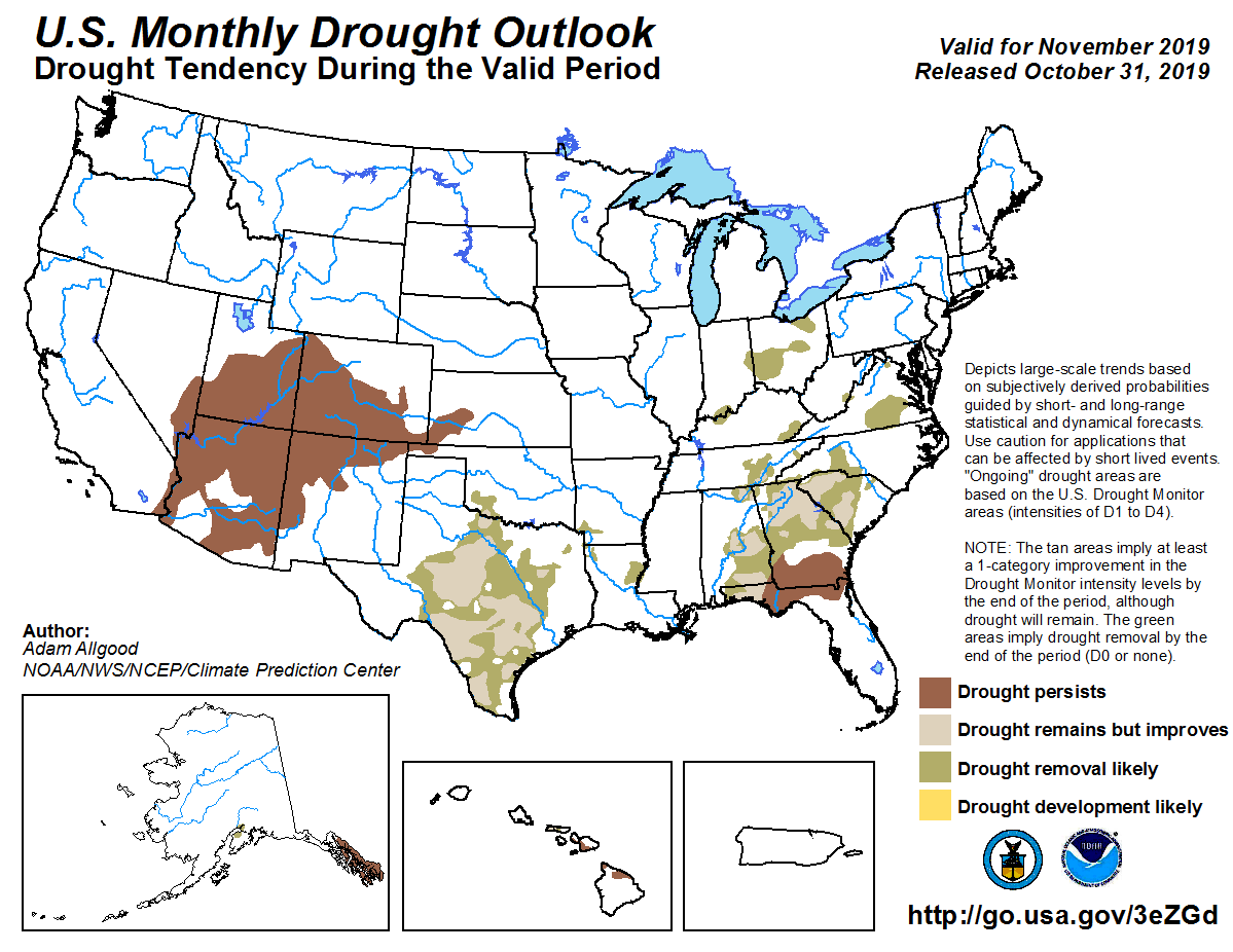 The Drought Outlook for November is not very encouraging, as dry conditions are expected to continue through the month. Based on this Climate prediction Center Forecast, made at the end of October, they are not expecting immediate relief in November.
–
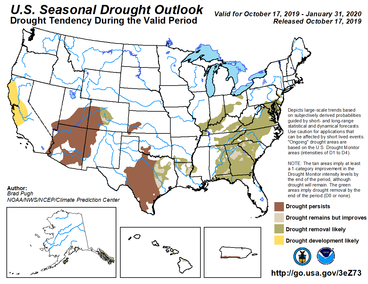 The longer ranged, Seasonal Drought Outlook is more favorable, so hopefully we won’t start 2020 in the US Drought monitor. However, this forecast map was created at the mid-point in October, so I would also suggest is less reliable.
–
 Temperatures
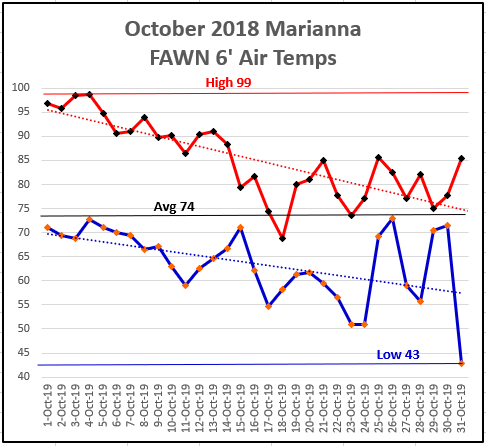
There was quite a contrast of temperatures in October 2019. The high for the month was 99° on October 2nd and 3rd. The low fell all the way down to 43° as Trick-or-Treaters scrambled across town on a blustery Halloween night. Thankfully the extreme heat finally declined in the second half of the month.
–
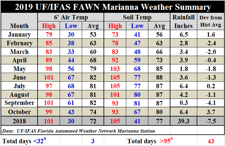
Average air temperatures dropped 8° from 82° in September to 74° in October, and average soil temperatures cooled 7°, from 87° to 80°. No doubt the nine rainy days in October helped cool things down, but primarily it was the cold fronts that made the biggest impacts.
–
November Outlook
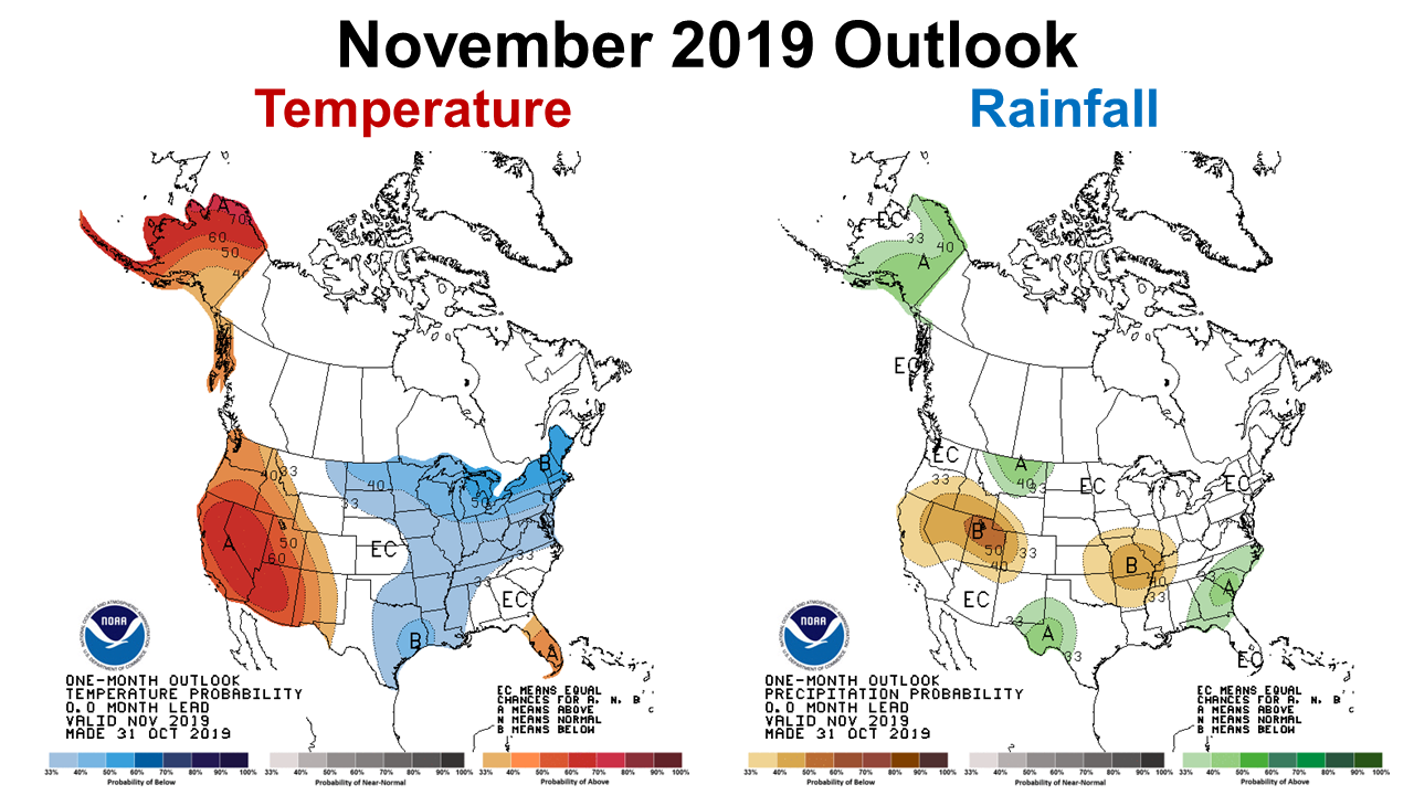
The Climate Prediction Center (CPC) weather outlook for the month of November is the first in some time that does not predict above average temperatures in the Panhandle. They are also expecting above average rainfall for the month. If their forecast holds true, this should help ease the drought conditions across the region, but there is some conflict with the drought forecast shared above.
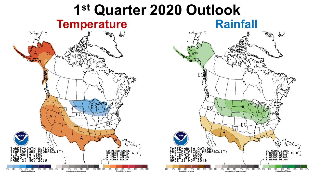 I did not share the picture, but the CPC December Outlook makes no predictions for rainfall, with equal chances for above or below average rainfall. The CPC is expecting that 2020 will be much warmer and also drier than normal in the Panhandle, through the first quarter of 2020.
–
ENSO Phase Watch – Neutral
The CPC is still expecting neither El Niño or La Niña this winter and spring. So, there is not an ENSO phase that will affect weather patterns this year, and also no real influence to base seasonal forecasts on.
Near-to-above average sea surface temperatures (SSTs) were observed in the Pacific Ocean during October. The pattern of anomalous convection and winds are generally consistent with ENSO-neutral. Forecasters believe this recent warmth reflects sub-seasonal variability and is not indicative of an evolution toward El Niño. The chances for El Niño are predicted to be near 25% during the winter and spring. In summary, ENSO-neutral is favored during the Northern Hemisphere winter 2019-20 (~70% chance), continuing through spring 2020 (60to 65% chance). Climate Prediction Center
–
What does all this mean for farmers?
At this late point in the year, the only crops being grown are cover crops and winter forages. November was supposed to bring extra rainfall, but that has not really happened thus far. It would be nice to start 2020 out on the Drought Monitor, but that looks less certain than before. With the Neutral ENSO phase, there are no seasonal indicators for climate forecasters to base long-range forecasts on.
So let’s all hope and pray for rain to close out 2019, to keep winter crops growing and to recharge the water table for the year ahead. However, the current mixed forecasts do not look good for pulling out of this long cycle of warm, dry weather anytime soon. Normally a good percentage of our annual rainfall comes in the early spring months, so I would expect drought conditions to continue improve some, but it probably will not be enough to get back to normal. Unfortunately we are adjusting to this, as we have not seen normal in several years. Let’s stay optimistic that 2020 will be a better crop year than 2019.
demayo@ufl.edu - 850-482-9620
Follow me on Twitter
@UFCowman