
June was a pretty good weather month for much of the Panhandle. Rainfall was not at all uniform, but was sufficient to remove most of Florida from the drought monitor at month’s end. Temperatures rose through the month, but were not extreme, compared to other years with high pressure and extended periods of triple digit temperatures.
–
 Rainfall

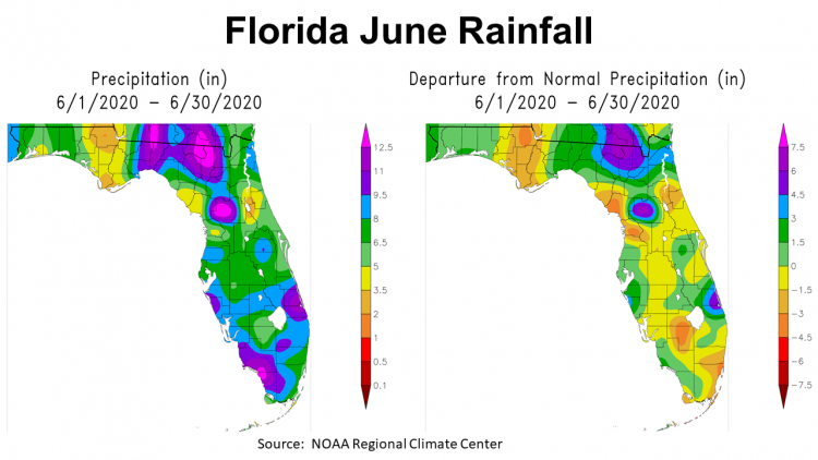
In the maps above it is clear that rainfall was not uniform in June. In the map to the right, you can see the central region of the Panhandle received 2-5″, while Northeast Florida was drenched with 8-12+” in June. The map to the right shows this disparity as well, with the areas in yellow or brown that were below average, and green, blue or purple were well above average.
–
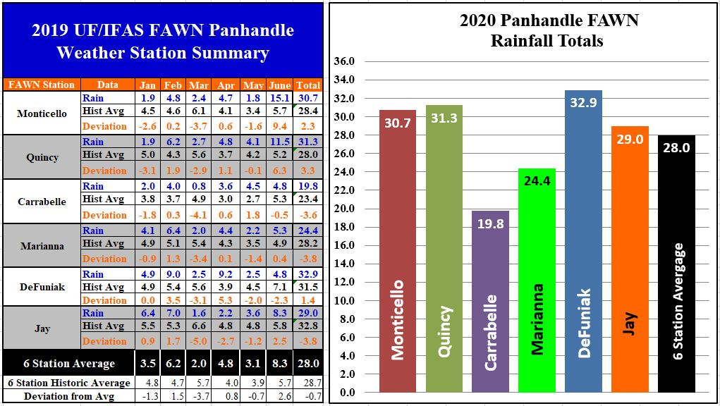
The Florida Automated Weather Network (FAWN) station summary above shows the contrast as you move across the Panhandle from east to west. A whopping 15.1″ fell in Monticello (9.4″ above normal), while only 4.8″ was recorded at the stations in Carrabelle and DeFuniak Springs. Four of the six stations were above historic average for June, with an average for all six stations of 8.3″, which was 2.6″ above average for the month.
Through the first half of 2020, the region as a whole was just below average, with all six stations averaging 28″, only 0.7″ below normal. The DeFuniak station had the highest total thus far with 32.9″, which is quite a contrast with Carrabelle that has only received 19.8″ over the first six months. Monticello nearly doubled their annual total in the month of June. But, when you look at each station’s total, you see that half are still below average for the year.
–
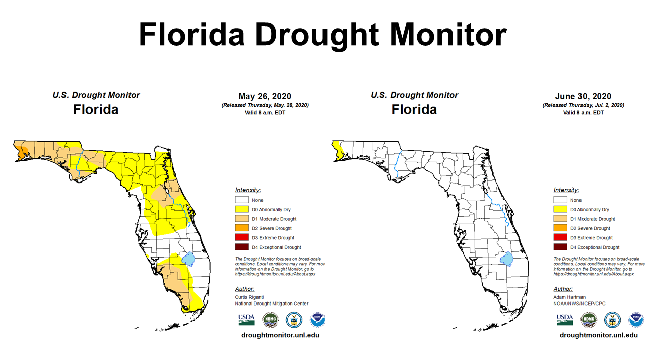 The Florida Drought Monitor comparison above shows the improvement in conditions from the end of May through the end of June. On June 30, only Escambia and the western edge of Santa Rosa Counties were still abnormally dry. This was quite a shift from moderate to severe drought only a month ago.
–
Temperatures
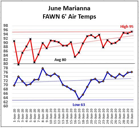
Certainly temperatures rose in June, but not to extremes. On June 28 and 30, the 6′-air temperature rose to 95°, but on the morning of June 17, the low was 63°. Temperatures rose towards the end of the month, but the average for the month was 80°.
–
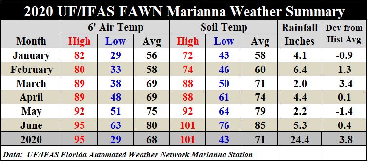
The 80° average air temperature for June was 5° warmer than the unusually cool May at only 75°. Soil temperatures rose 6° from 79° in May to 85° in June. The high soil temperature of 101° on June 30 was a reminder that it is even hotter at the ground level, so soils can dry out very quickly when the air temperatures are above 95°.
If you would like to see a summary of the daily high and low temperatures and rainfall at the Marianna FAWN station, or monthly totals for all six station, use the following link for complete details: January-June 2020 FAWN Weather Summary
–
July Outlook
The Climate Prediction Center (CPC) is expecting the trend of above average temperatures and rainfall to continue in July.
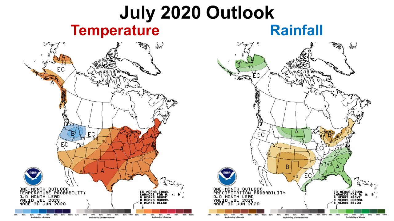
When you combine these two maps this is a favorable forecast for the southeast, but not so great for the high plains of Texas, Oklahoma, and New Mexico that are already in moderate to extreme drought. If this forecast holds true, Florida stay out of the Drought Monitor through July and perhaps through the summer.
–
La Niña Watch
Forecasters do not like to predict ENSO phases in the summertime, because conditions are more variable. However, there is a growing consensus that we may have a La Niña fall and winter of 2020-21.
The prediction models are roughly split between La Niña and ENSO-neutral during the fall and winter. Based largely on dynamical model guidance, the forecaster consensus slightly favors La Niña development during the August-October season, and then lasting through the remainder of 2020. In summary, ENSO-neutral is favored to continue through the summer, with a 50-55% chance of La Niña development during Northern Hemisphere fall 2020, and continuing through winter 2020-21(~50%chance).
Climate Predication Center
–
So What does this mean for farmers and ranchers in the Panhandle?
The slow start to the growing season, caused by reduced rainfall, should continue to improve. Current short term (1-month) and intermediate (3-month) outlook forecasts anticipate warm, wet conditions to continue for the Southeast over the next three months. The outlook forecasts indicate that drought should not be as serious a concern for the remainder of the growing season. This is good news during the COVID induced economic crisis. While most commodity prices are really low, if the CPC forecasts are correct, farmers can expect above average yields for fields that are in decent shape now. Pastures and hay fields that finally received enough moisture to grow well in June should continue through the summer. A La Niña this fall would not be as favorable, as this means drier conditions than normal for the Southeast. But the 50/50 forecast shows they really don’t know yet, so we need to stay tuned to the ENSO forecasts, before decisions are made about planting winter crops and forages.
demayo@ufl.edu - 850-482-9620
Follow me on Twitter
@UFCowman