
Rainfall
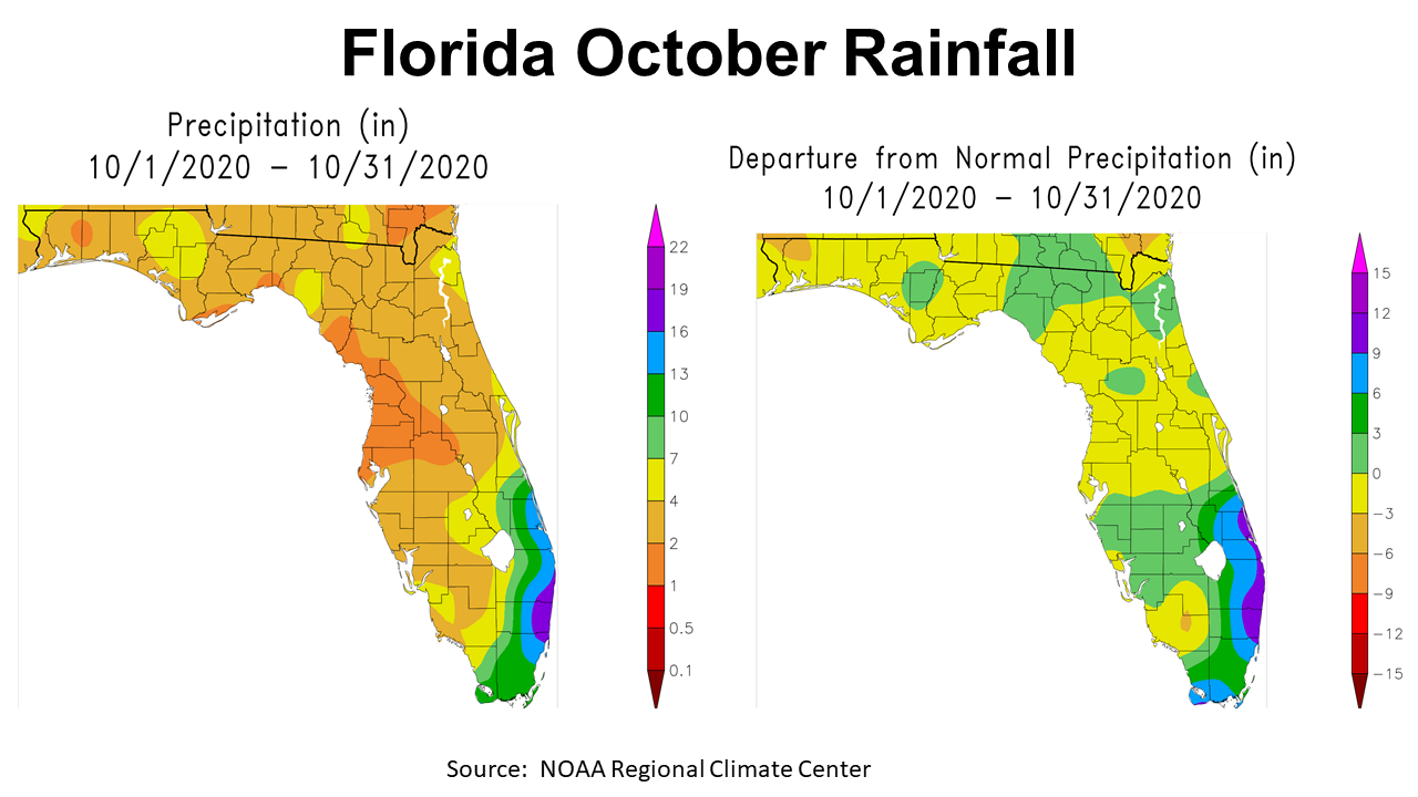
Historically, October is the driest month of the year in the Panhandle. After an extremely wet September, October was a welcome change for crop and hay producers trying to finish the harvest season. In the graphic above, the map to the left shows estimated total October rainfall in Florida. Counties in the Panhandle ranged from 1-7″. The map to the right shows the departure from normal rainfall. The majority of the Panhandle was below average (yellow, tan, and brown), but Calhoun, portions of surrounding counties were slightly above average (light green). Only the Southeast coast of Florida was well above average in October.
–
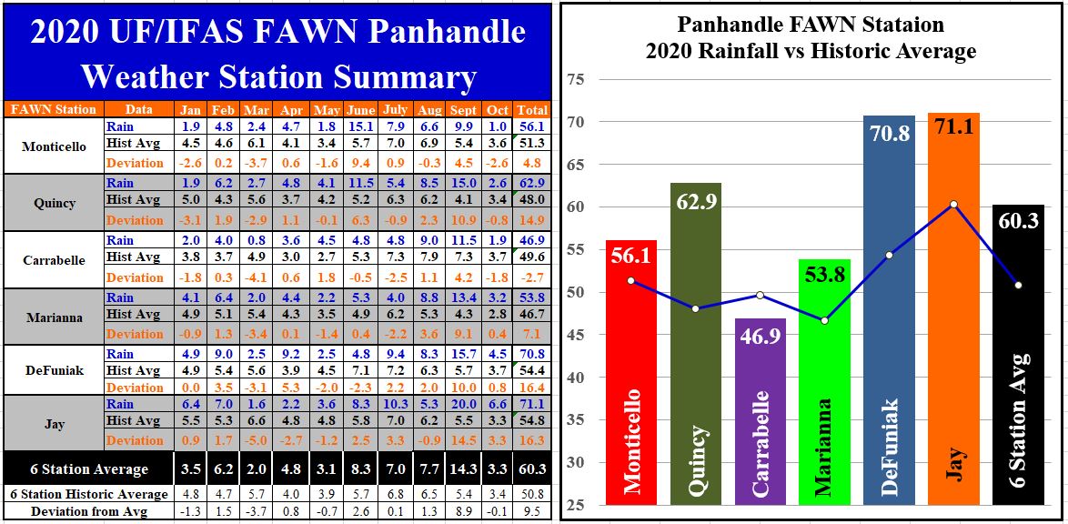 The six Florida Automated Weather Network (FAWN) Stations showed the variation across the Panhandle in October 2020. The driest location was at Monticello, with only 1″, while the station in Jay, that received moisture from a passing tropical storm, received 6.6″ for the month. The stations in Jay, DeFuniak, and Marianna recorded above historic average rainfall, while Monticello, Quincy and Carrabelle were below average. The average for all six stations was 3.3″, which was only -0.1″ below normal for October.
Through ten months of 2020 the driest location has been in Carrabelle, with 46.9″ thus far, while 71.1″ has been recorded at the Jay Station. The white dots in the blue line in the right-hand chart above shows historic average for each location through 10 months in comparison with the actual total. Only the Carrabelle site has recorded below histrionic average (49.6″) thus far in 2020.
–
Temperature
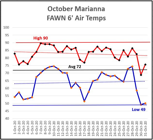
The temperature fluctuation in October was considerable. On October 7th, the afternoon high temperature was 90°. On October 30th, the low for the month was 49°, which was the lowest early morning temperature since April 2nd.
–
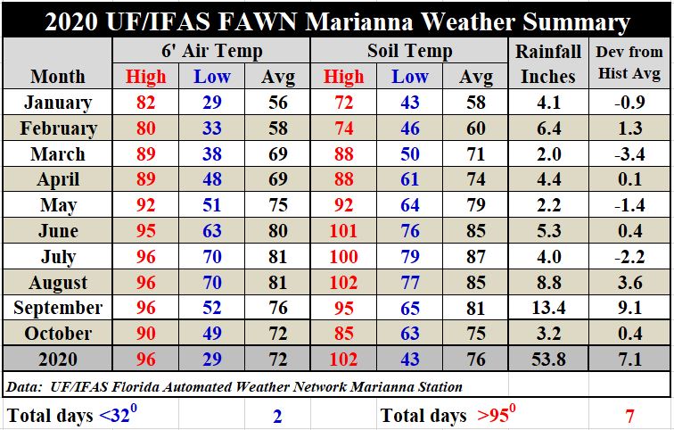
The average air temperature for October was 72°, so it was 4° cooler than the 76° average in September. Soil temperatures cooled 6°, from an average of 81° to 75°.
Download the complete summary of daily rainfall and temperature data at the Marianna FAWN site, and monthly rainfall totals from all six stations in the Panhandle by using the following link:
January-October 2020 Panhandle FAWN Weather Summary
–
 November and Winter Outlook
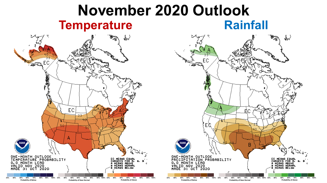
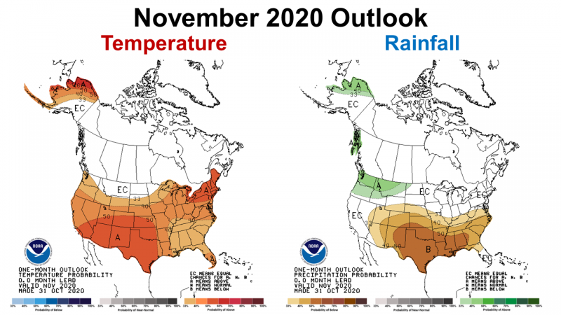
The Climate Prediction Center (CPC) release their November climate outlook last week. They are expecting La Niña to start affecting local weather in November. They are forecasting above average temperatures across the Southeast in November. The CPC is also predicting below average rainfall, especially across the western counties in the Panhandle.
–
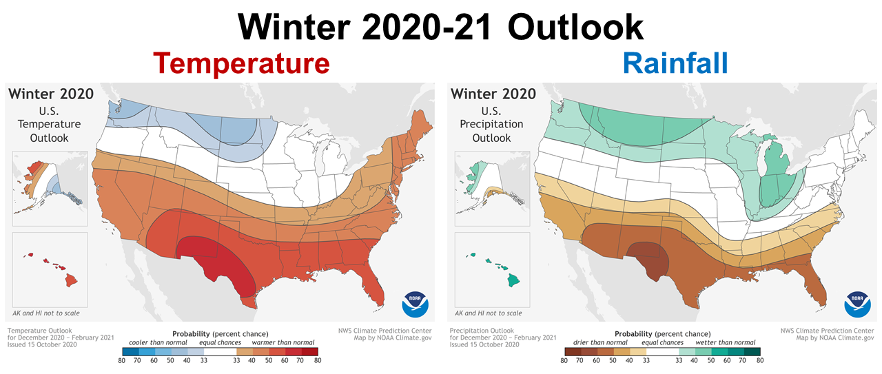 A few weeks ago, the CPC released their Winter 2020-21 outlook for December through February. Based on La Niña, their longer term outlook has even higher probabilities of a warmer, dryer than normal winter.
–
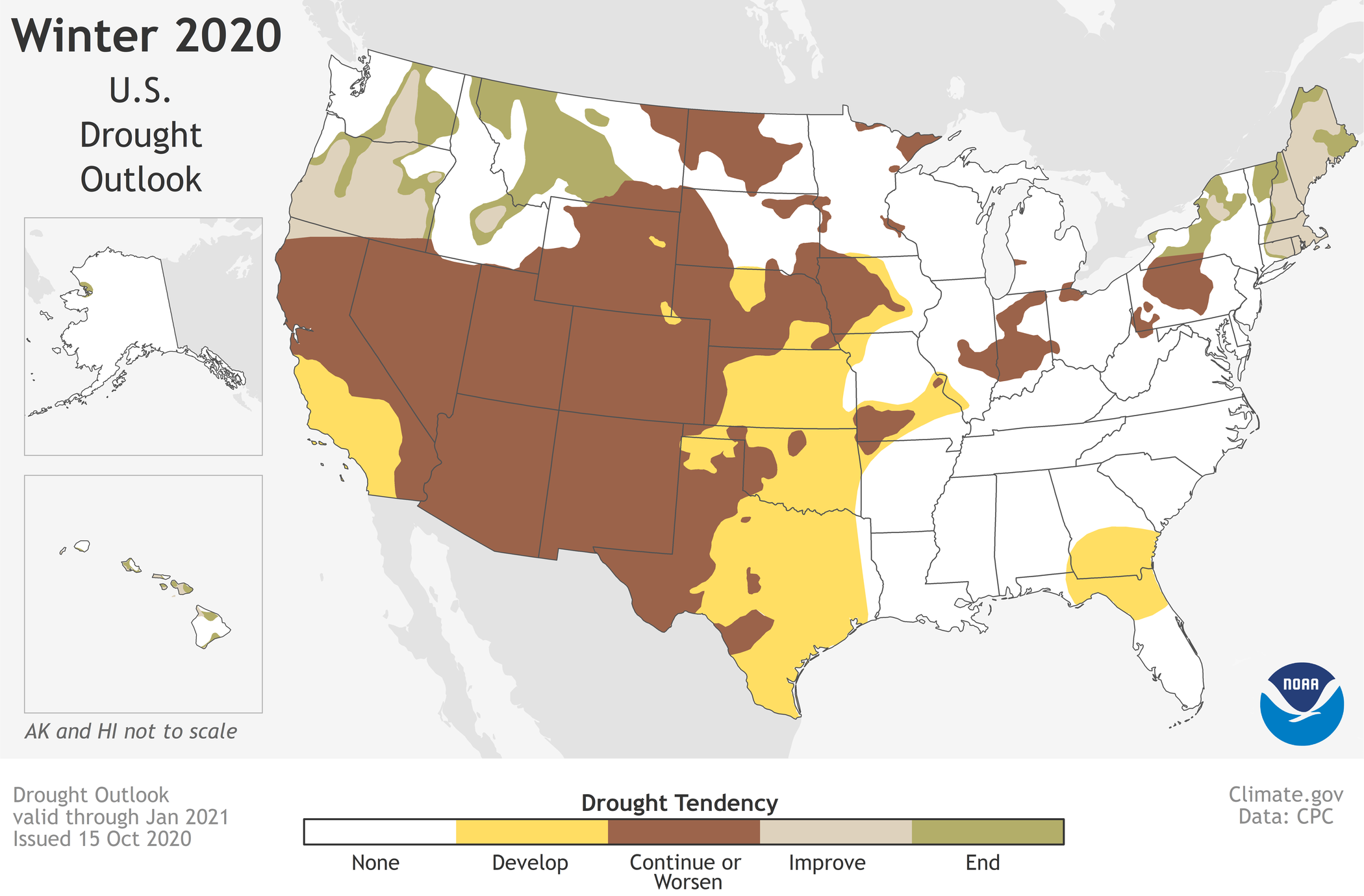
As you would expect from this extended drier than normal forecast, the drought conditions will worsen in some parts of the country, and will develop across Southern Georgia and North Florida.
You can learn more about the CPC winter 2020-21 outlook in the following short video:
–
What does this mean for farmers and ranchers in the Panhandle?
The CPC is expecting La Niña to effect weather in November through January, and possibly continue through April. The following is the latest statement from the CPC:
La Niña conditions are present. Equatorial sea surface temperatures are below average from the west-central to eastern Pacific Ocean.The tropical atmospheric circulation is consistent with La Niña. La Niña is likely to continue through the Northern Hemisphere winter 2020-21 (~85% chance) and into spring 2021 (~60% chance during February-April).
Farmers and ranchers can expect a warm dry winter, with the possibility of the La Niña influence lingering through April. This does not mean that there won’t be cold snaps, with frontal rainfall, but the CPC is expecting a reduction in activity for our area. Winter forage and small grain crops may require irrigation to provide optimal performance. It also appears the longer you wait to plant, the worse conditions may become. So, if you have not planted these crops yet, be selective and choose irrigated fields, or those that retain moisture well. It could also be challenging for crops planted in early spring such as vegetables, melons and field corn. If winter rainfall is considerably reduced, this could even affect warm season crop planting later in the spring, but this outlook is less certain at this point. It is possible that the 2021 growing season may begin in a developing drought situation, but it is really too early to know for sure. Check back next month for updated outlook forecasts.
demayo@ufl.edu - 850-482-9620
Follow me on Twitter
@UFCowman