
Rainfall
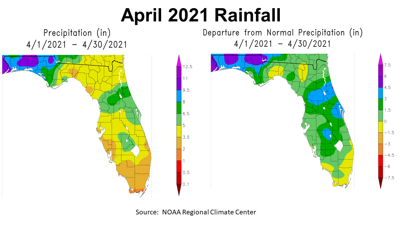
April 2021 was a unique month with cooler than average temperatures and above average rainfall for much of Florida. In the map to the left above, you can see the estimated rainfall totals for April with areas in purple reviving more than 9.5″, blue shaded areas over 8″, green 6.5″- 8″, light green 5″ – 6.5″, yellow 3.5″ – 5″, and tan 2″ – 3.5″. All of these totals are put into perspective in the map to the right that shows departure from normal. Areas shaded in yellow were below average, but areas in green, blue and purple were above average. By far, the majority of the state of Florida was above average for the month of April, but the areas shaded blue were 3′ – 4.5″ above normal, and in purple 4.5″ – 6″ above normal. It is interesting how the totals were split along the Apalachicola River in the Panhandle, but it is common for fronts to move west to east and then shift north at some point.
–
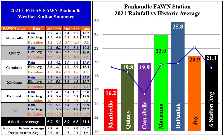
The Florida Automated Weather Network (FAWN) stations show this variation in rainfall more precisely for the month of April. Only the Monticello 2.7″ and Quincy 3.4″ stations were below average for the month. The wettest locations were DeFuniak Springs with 10.5″, Marianna 8.6″, and Jay 8.3″. The average for all six Panhandle FAWN stations was 6.3″, which was 4″ above normal for the region. Through the first third of 2021, only Monticello -3.2″ and Jay – 1.3″ were below average. So far in 2021, the DeFuniak station has recorded 25.8″, which is 6″ above normal, and Marianna with 23.9″ was 4.2″ above average. The average for all six stations was 21.1″, which is almost 2″ above normal from January through April.
–
 Temperatures
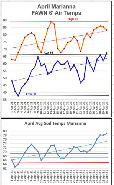
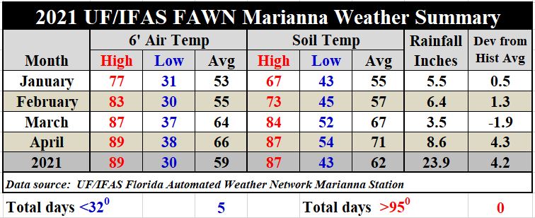
April 2021 had pretty significant temperature swings with a high of 89° on 13th, and a low of 38° on April 3rd. Compare this to the last five years: April 2020 low was 48°, 2019 low 44°, 2018 low 40°, 2017 low 42°, and 2016 low 44°.
After a fairly cool start to the month, temperatures climbed quickly, so the average air temperature for the month was 66°, which was only slightly cooler than NOAA’s April 1901-2000 mean of 67° in Marianna. So 2021 was certainly cooler than recent years, but actually fairly close to historic average from the previous century.–
The daily average soil temperature dipped down to 63° on April 2, but warmed quickly and remained above 70° after April 18, which is the ideal temperature for peanut seed germination.
As compared to March, the average air temperature of 66°was only 2° warmer than the 64° average in March. The average soil temperature warmed 4° from 67° in March to 71° in April.
You can download the complete daily summary of temperatures and rainfall from the Marianna FAWN station, and the monthly rainfall summary from all six stations in the Panhandle in the following summary report: Jan-Apr 2021 Jackson County Weather Summary
 –
–
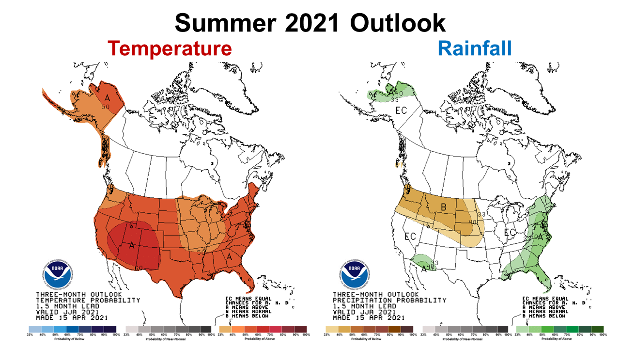
Summer Outlook
The Climate Prediction Center (CPC) will provide an update to their summer temperature and precipitation outlook next week (May 20), but the prediction generated last month shows that we can expect a warm moist summer. Notice the certainty of above average precipitation is reduced for central time zone counties. After such a pleasant spring, a hot summer is not the greatest news, but they are not expecting drought conditions over the summer months.
–
La Niña Watch
La Niña has officially ended for now, so this plays in to the CPC forecast of above average precipitation.
During April, the tropical Pacific Ocean returned to ENSO-neutral conditions as the coupling between the atmosphere and ocean weakened. Sea surface temperatures were near-to-below average across most of the equatorial Pacific Ocean in the past month. Most of the forecast models predict a continuation of ENSO-neutral through the Northern Hemisphere summer 2021. The forecaster consensus agrees with this set of models through the summer, and then begins hedging toward cooler conditions as the Northern Hemisphere fall approaches. La Niña chances are around 50-55% during the late fall and winter. However, there is typically large uncertainty with forecasts made in the spring, so confidence in ENSO-neutral for the coming seasons is highest. In summary, La Niña has ended, with ENSO-neutral likely to continue through the Northern Hemisphere summer (67% chance in June-August 2021). Climate Predication Center May 13, 2021 Report
–
What does this mean for farmers and ranchers in the Panhandle?
Not having drought in the forecast is always good news, but farmers do not want excessive moisture either. While we have all enjoyed a cool spring, our crops and forages were developed to thrive in summer heat. High temperatures in the low 90s are OK, but temperatures above 95° reduce pollination for fruit, nut, and seed production. So far in 2021 there have been no highs in the 90s, but we all know they will start at some point in late May and carry on through the summer. Pastures are green now, but are growing slowly. Based on the most recent CPC Outlook, I would expect normal summer to kick in in the near future. As fields slowly dry out again, farmers should be able to get back on schedule planting crops. If moisture continues to remain above average, fungal disease issues may increase. It is also fairly normal for a La Niña fall-winter to follow a previous one, so we will have to see how this forecast changes through the end of the summer and early fall. Soils could start to dry out this fall, which is good for timely crop harvest, but more challenging for winter crop and forage plantings. I remain optimistic that 2021 will be a balanced year without extremes of heat or excess moisture, but it will really depend on the tropical storm season ahead. We seem to be in a transition period, so check back in again n a few weeks when I share the May summary to see what changes are expected in future CPC outlook predictions.
demayo@ufl.edu - 850-482-9620
Follow me on Twitter
@UFCowman