
 Rainfall
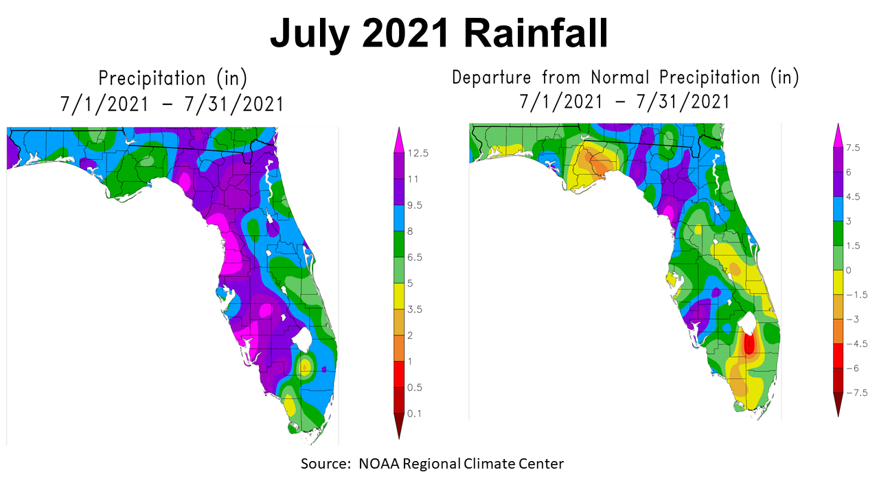
July was a very wet month in some areas, but drier than normal in others. It also got really hot at months end, breaking the streak of nine months below 95°. In the map to the left above you can see that much of the Panhandle received 8-9.5″ (blue), while east of the Apalachicola River rainfall ranged from 5-8″ (green). This map also clearly shows the rainfall impact of Tropical Storm Elsa that went ashore in Levy County, but provided heavy rainfall with over 12.5″ (hot pink) along the Peninsula Gulf Coast. The map to the right above compares the rainfall totals to normal. July is typically one of the wettest months of the year in Florida, but east of the Apalachicola River there were several counties that were 1.5″ to 4.5″ below normal. There was quite a contrast where Elsa’s rain hit and missed in the Big Bend. Only Bay County was well above normal (blue) with most of the Western Panhandle 1.5″ (light green) to 3″ above average (green).
–
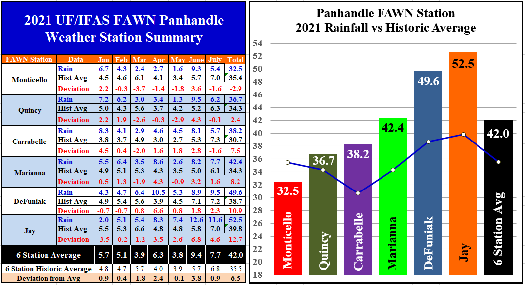
The six Florida Automated Weather Network (FAWN) documented the distinct variation in rainfall in July. The highest total of 11.6″ fell in Jay (4.6″ above average), and De Funiak Springs was not far behind with 9.5″. The driest location was in Monticello where only 5.4″ were recorded in July, which was -1.6″ below normal. The three locations in the Eastern Time Zone were below average and the three in the Central Time Zone were above average. The average for all six stations was 7.7″, which was almost an inch above historic average.
Through the first seven months of 2021, all six stations averaged 42″, which is 6.5″ ahead of historic average for this time frame. The wettest location was in Jay with 52.5″ so far this year, which was 12.7″ higher than normal. By contrast, only 32.5″ has been recorded thus far in Monticello, almost 3″ below normal. There is almost a perfect stair step of rainfall as you move from east to west across these six locations.
–
 Temperatures
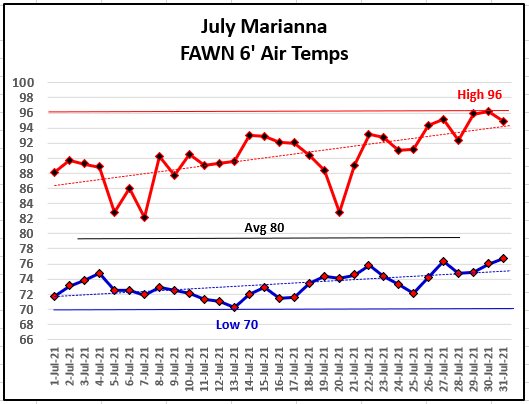
With all of the rain early in the month, daily air temperatures were relatively moderate through the first half of the month, but by months end much of the Panhandle was scorching hot. The low for the month of July came on July 13 at 70°. It was 96° on July 29 and 30, and when combined with our humidity provided triple digit heat advisories to close out July.
–
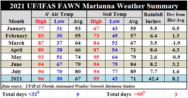
With a mix of cloudy and rainy weather early, and then scorching hot late, the average air temperature only rose 1°, from 79° in June to 80° in July. There were 3 days with high temperatures over 95°, which has not happened since September 4th, 2020. 95° is a key temperature for crop and livestock stress. The average soil temperature rose form 84° in June to 85° in July. So July has been the hottest month so far, but not that different from June.
To see the daily high and low temperatures and rainfall data from the Marianna FAWN station, and the monthly totals from all six FAWN stations in the Panhandle, use the following link: Jan-July 2021 Jackson Co Weather Summary
–
Climate Outlook
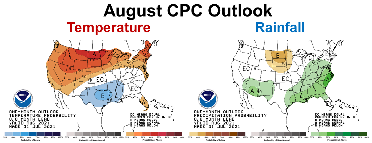
The Climate Prediction Center (CPC) released their most recent one month outlook at the end of July. They are expecting near normal temperatures, but indicate a 40% change of above average rainfall across North Florida in August. So, it does appear we can expect the wet growing season to continue for another month. I know this is not the forecast farmers and hay producers were hoping for, but at least the crops and grass are growing, but then again so are the fungi and insects. Baleage may continue to be the best option to harvest forages for yet another month.
–
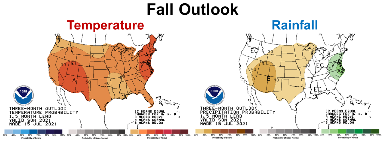
There is a change for the longer ranged CPC Fall Outlook for September through November. This far out it is more challenging to predict, but at this point they are expecting a change from ENSO-Neutral to La Niña and are expecting the wet summer weather to change to more normal rainfall this fall. This is good news heading into peanut, cotton, and must-have hay harvest season.
–
La Niña Watch
As I mentioned earlier the CPC is expecting a return of La Niña at some point in the coming months. The greatest affect to the climate will likely be this winter.
ENSO–neutral conditions are present. Equatorial sea surface temperatures (SSTs) are near–to–below average across most of the Pacific Ocean.ENSO–neutral is favored through the Northern Hemisphere summer and into the fall (51% chance for the August–October season), with La Niña potentially emerging during the September–November season and lasting through the 2021–22 winter (66% chance during November–January). Climate Prediction Center
–
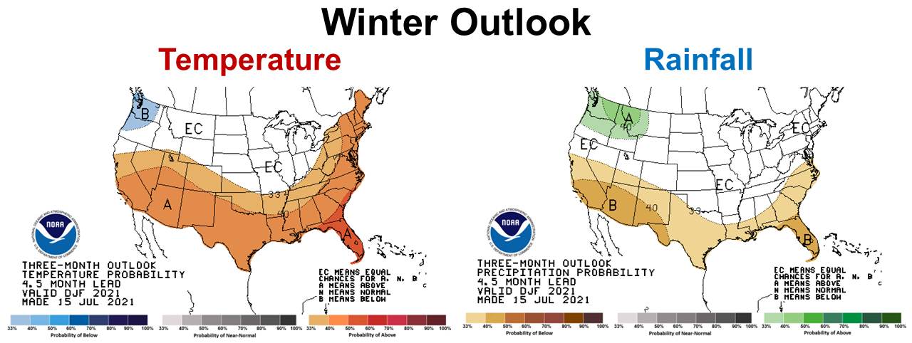
The way-to-early to trust CPC winter outlook shows the predictable affects of a La Niña winter in the southern states, especially in Peninsular Florida. But we should get a much more dependable forecast once they know for sure that La Niña will return. Right now it is just their best scientific guess to expect a warm dry winter.
–
So what does this mean for farmers and ranchers?
The 30-day outlook indicates that August may be much like June and July, so disease and pest management will continue to be issues in wet fields. You may want to call and get on the list for aerial sprayers, as planes may be the best options for pest management over wet fields in August. Fall is coming, and this fall is expected to be warmer than normal but with typical fall precipitation. That should provide better harvest weather, as October and November are traditionally drier months. Hay harvest that has been so frustrating thus far, should improve, but likely not until later this fall. It does seem that 2021 is going to be a wet year for the Western Panhandle. The whole state of Florida has been out of the drought monitor for several months and that trend should continue. it is still too early to truly make winter crop and forage plans, but at this point it does appear that another round of La Niña is coming. Last year the Polar Vortex trumped La Niña, but that is a pretty rare occurrence. Stay tuned and we will see what the CPC predicts at the end of August.
demayo@ufl.edu - 850-482-9620
Follow me on Twitter
@UFCowman