
 Rainfall

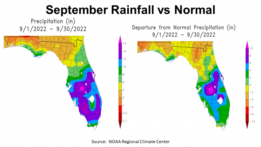
September was a dry month for much of the Panhandle. The map to the left above shows estimated rainfall in September across Florida. In the Panhandle, you can see that only a narrow band along the Gulf Coast received over 6″ (green & blue). Most of the Panhandle was in the 1-4″ range (orange & gold). The map to the right shows the departure from normal rainfall. Again you see a very narrow band that was above historic average (green & blue). All of the rest of the Panhandle was below average. Escambia and Santa Rosa were -4″ to -6″ below average (orange), while much of the Central Panhandle was -2″ to -4″ below average (gold).
–
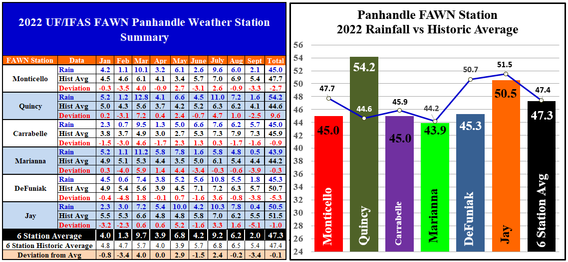
You can see more specific rainfall data from the six Florida Automated Weather Network (FAWN) stations in the Panhandle. The driest location was in September was Jay with only 0.4″, -5.1″ below historic average. Marianna was not much better with only 0.5″, -3.9″ below normal. The station at Carrabelle, on the other hand, received 5.7″ for the month, which was still -1.6″ below normal. The average for all six stations was 2.0″, which was -3.4″ below average.
–
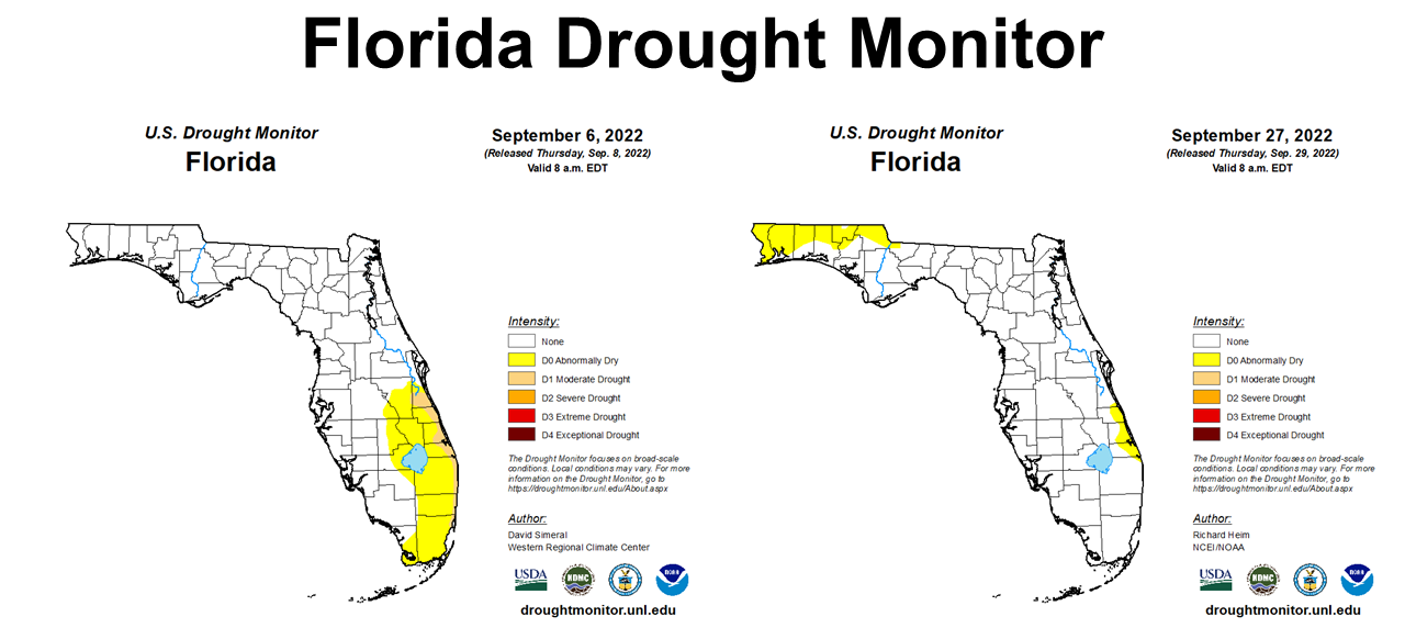
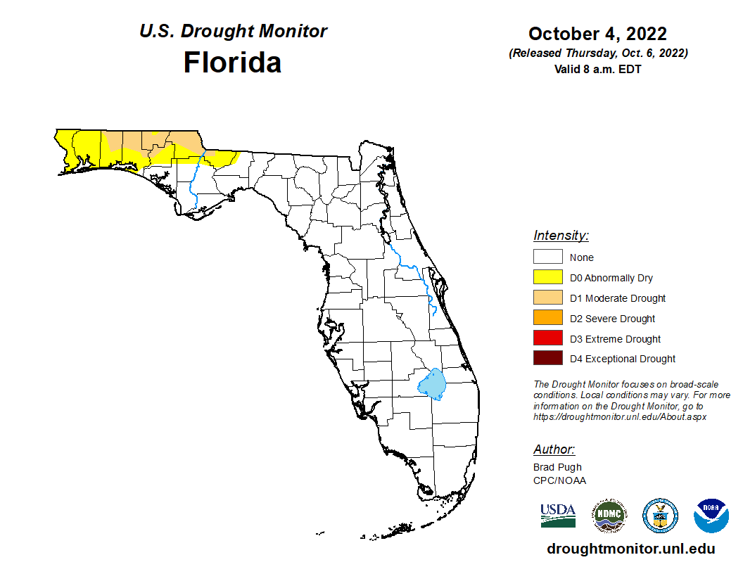 In the graphic above you can see the Florida Drought monitor at the beginning and end of September. With such low rainfall totals in September, it is not surprising that much of the agricultural region of the Panhandle is back on the US Drought Monitor in the D0, Abnormally Dry category at the end of September. The October 4 drought monitor (right) shows that there are now portions of six counties that are included in the moderate drought category. These areas have not had measurable rainfall since September 11. We need rain need rain in the Panhandle!
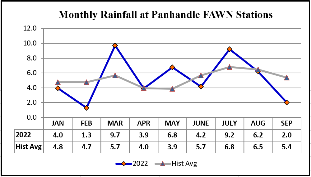
Through the first 3/4 of 2022, the station in Quincy has recorded the highest total of 54.2″, 9.6″ higher than normal. Contrast that with Marianna, where only 43.9″ has been collected thus far, -0.3″ below average. The average for all six FAWN Stations through September was 47.3″, which is only 0.1″ below normal for the entire region. Looking at these numbers, you might think, “Oh this is was an average year.” However, when you look at the monthly totals vs historic average in the graph below, you can see the drought vs. wet variation through the year with 9.7″ in March, and 9.2″ in July compared with 1.3″ in February and 2″ in September.
 –
–
–
 Temperatures
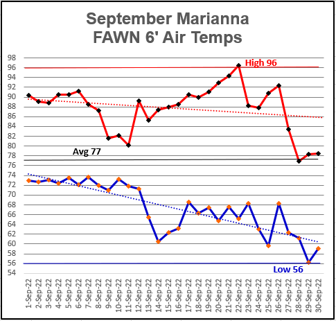
Temperatures in September were quite variable, ranging from a 6 ft. air temperature high of 96° on September 22, and a low of 56° a week later on September 29. It is not very often that there is a 40° temperature spread in the same month, much less in a single week. The average temperature for September was 77°.
–
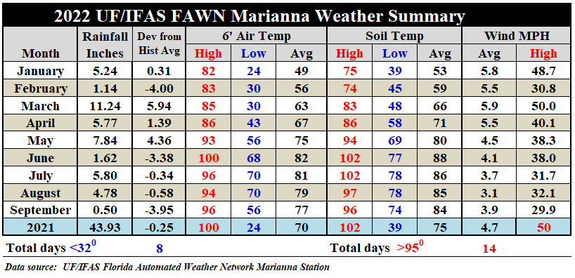
From the above weather summary of the Marianna FAWN station data, you can see the building drought at this location. May was the last month with above average rainfall. You can also see that while September was cooler than the previous months, it was not a huge change. The average air temperature dropped from 81° in July, to 79° in August, and 77° in September. Average soil temperature change has been even more subtle ranging from 86°, to 85°, and 84° in September. Without storms coming through, the winds were also fairly minimal with a 3.9 mph average and a maximum gust just under 30 mph.
You can review the full daily weather summary from the Marianna FAWN station, and monthly rainfall totals from all six FAWN stations in the Panhandle by using the following link: 2022 Jan-Sept Jackson Co Weather Summary
–
Last Quarter Climate Outlook
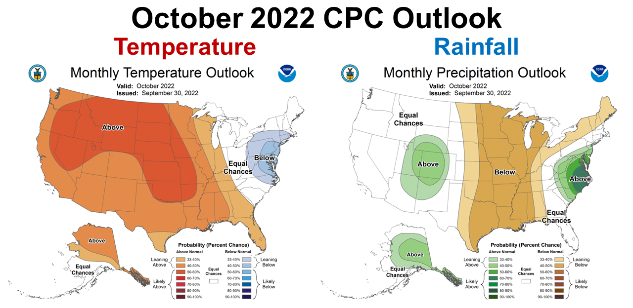
The Climate Prediction Center (CPC) updated their October Climate Outlook last Friday. They expect all of Florida to me warmer than normal, but the precipitation outlook is split. Georgia and Peninsular Florida is expected to be normal, but west of the Apalachicola River is expected to be drier than normal. October is historically one of the driest months of the year, so normal or even above normal is still relatively dry. October is the traditional time to plant winter forages for grazing and cover crops. This outlook does not look favorable for cool-season crop establishment.
–
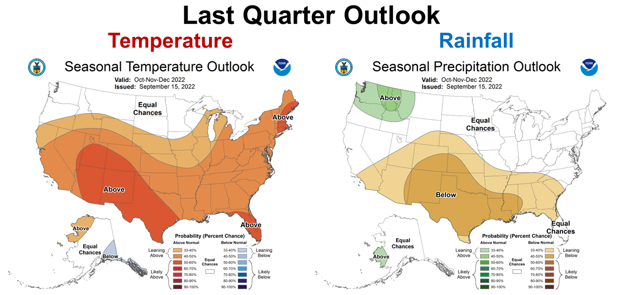
The 3-month climate outlook is not any better. All of North Florida is expected to be warmer and drier than average through the final quarter of 2022. The CPC is expecting La Niña to significantly affect the weather at the end of 2022.
–
 –
–
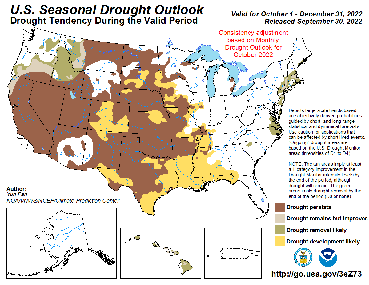
Drought conditions are expected to develop all along the Gulf Coastal Region which includes much of the Panhandle. It already is dry and is expected to continue to remain dry through the end of 2022.
–
La Niña Advisory
Prepare for round three of a La Niña fall and winter. Based on the impact of La Niña to the Southeast, we can expect warmer and drier conditions to continue for several months.
La Niña is present. Equatorial sea surface temperatures (SSTs) are below average across most of the Pacific Ocean. The tropical Pacific atmosphere is consistent with La Niña. La Niña is favored to continue through Northern Hemisphere winter 2022–23, with a 91% chance in October–November, decreasing to a 54% chance in January–March 2023. Climate Prediction Center
–
What does this mean for Panhandle Farmers and Ranchers?
There was no good news in any of the resources I shared for long range forecast information. It is dry, it is expected to stay drier than normal through the end of the year, and perhaps drier than normal through March. Typically the Panhandle gets pretty good moisture from frontal rains in the late winter and early spring. The CPC climate forecasts indicate an expectation that these fronts will provide less rainfall than normal, but that does not mean none at all. It does suggest that cover crops and cool-season annual forages should be planted in irrigated fields, or areas with good moisture holding capacity. If your farm has relatively sandy, well drained soils, this likely is not the best year for planting small grains and ryegrass. These forecasts also suggest dry conditions at planting time. I would not skip planting all together this year, as cool-season annuals are the best quality forages we can produce. I would be strategic in selecting fields for making this investment that have been productive in the past, especially in the previous two La Niña years. There are a number of irrigated fields that could be utilized for planting grazed forages instead of traditional winter cover crops, if a suitable arrangement for both grazing and warm-season crop production can be negotiated. I would not recommend overseeding existing pastures with ryegrass this year, unless you get excellent moisture for planting in November. I would also suggest producing oats or wheat for grain in irrigated fields, if possible. On a more positive note, it does appear that we will continue to have dry weather for peanut and cotton harvest, although without moisture these crops will decline and yields and quality may be reduced.
demayo@ufl.edu - 850-482-9620
Follow me on Twitter
@UFCowman