
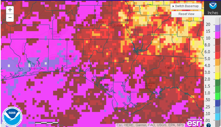
 August was another rainy month across the Panhandle, but there was a wide variation in rainfall across the region. The western counties had large areas with 10-15 inches (hot pink) and even some areas nearer to the coast with more than 15″. The eastern counties were much drier, except along the coast with a range of 5-10″ (red), but there were isolated locations that had less than 5″ (tan). As hard as it may be for farmers in Escambia, or Santa Rosa to believe, it got pretty dry in parts of Leon and Gadsden Counties in August.
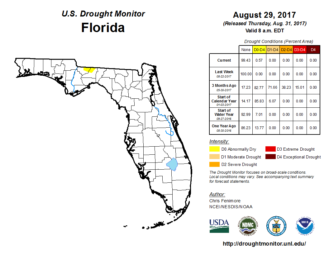 Florida showed up for the first time since June 20 in the U.S. Drought Monitor. Quite a number of Southwest Georgia counties just to the north of Gadsden and Leon were moved into the Abnormally dry category at the end of August.
FAWN Weather Summary
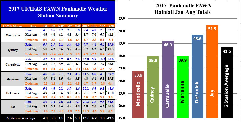 The Florida Automated Weather Network (FAWN) stations also showed the variation in rainfall for the month of August. The highest rainfall total was recorded in Jay with 9.6″ in August, with DeFuniak recording 9.5″. Marianna was the driest location with only 4.5″. Only the Marianna station recorded less than historic average for the month of August. The average for all six stations was 8.0″ in August.
Through the first eight months, the Jay station has recorded 52.5″ in 2017, while only 33.9″ were recorded in Monticello. All six stations averaged 43.5″ thus far for the year. For the year, both Quincy and Monticello have recorded less than historic average for the first eight months of the year. The Monticello location is 8.4″ below historic average for rainfall.
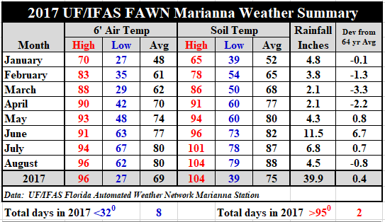 Soil temperatures heated up by one degree from an average of 87° in July to 88° in August. The average air temperature held at 80°. The high for the month was 96° on August 20 and 25, with the low of 62° on August 1. For daily temperature and rainfall records, Use the following link: 2017 Jan-Aug Weather Summary
Harvest Weather Outlook
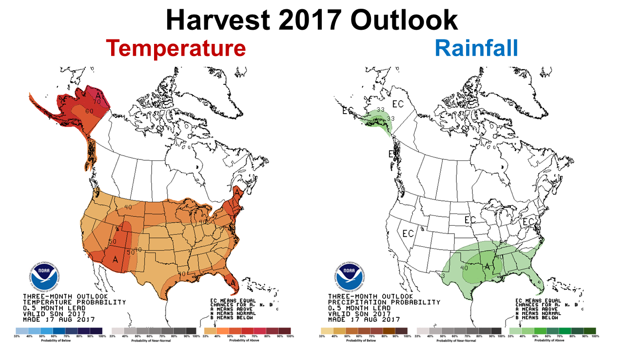 The Climate Prediction Center is expecting above average temperatures and rainfall from September through November. The latest projections call for 73% chance of warmer than normal temperatures and a 66% chance of higher than normal rainfall over the next three months. It does not appear that the perfect harvest experienced in 2016 will return in 2017, but rainfall during this three-month period is historically lower than other months. Certainly everyone needs to pay close attention to the tropics. A major storm the size of Hurricane Irma could wreak havoc on peanut and cotton harvest for a large area.
ENSO Phase Outlook
The Climate Prediction Center is pretty clear in their forecast that they do not expect an El Niño this winter. Neutral conditions currently exist and should continue. Here is an excerpt from their latest ENSO phase outlook:
ENSO-Neutral conditions are present. Equatorial sea surface temperatures (SSTs) are near-to-below average across the central and eastern Pacific Ocean. ENSO-Neutral is favored (~85% chance during Jul-Sep, decreasing to ~55% during Dec-Feb) through the Northern Hemisphere winter 2017-18 Climate Prediction Center
So what does this forecast mean for area farmers? Forecasters are not expecting influence from Pacific Ocean winds and weather to affect the US this fall and winter. Farmers planning for cool-season crops can expect normal rainfall with no influence from Pacific Ocean ENSO phases. If you go back in history, however, you will see that many of the ENSO neutral years were the ones with the hardest freezes and lowest temperatures. In the end it is expected to be a normal winter, but what is normal lately? It has been a number of years since there has been a normal weather in the Panhandle of Florida. Maybe 2017-18 will get cold enough to reduce populations of whiteflies and other pests.

demayo@ufl.edu - 850-482-9620
Follow me on Twitter
@UFCowman
- Making the Most of High Cattle Prices – Grow More of Your Own Feed - July 18, 2025
- Friday Feature:1960 Corn Farmer - July 18, 2025
- June 2025 Weather Summary and Three-Month Outlook - July 11, 2025