
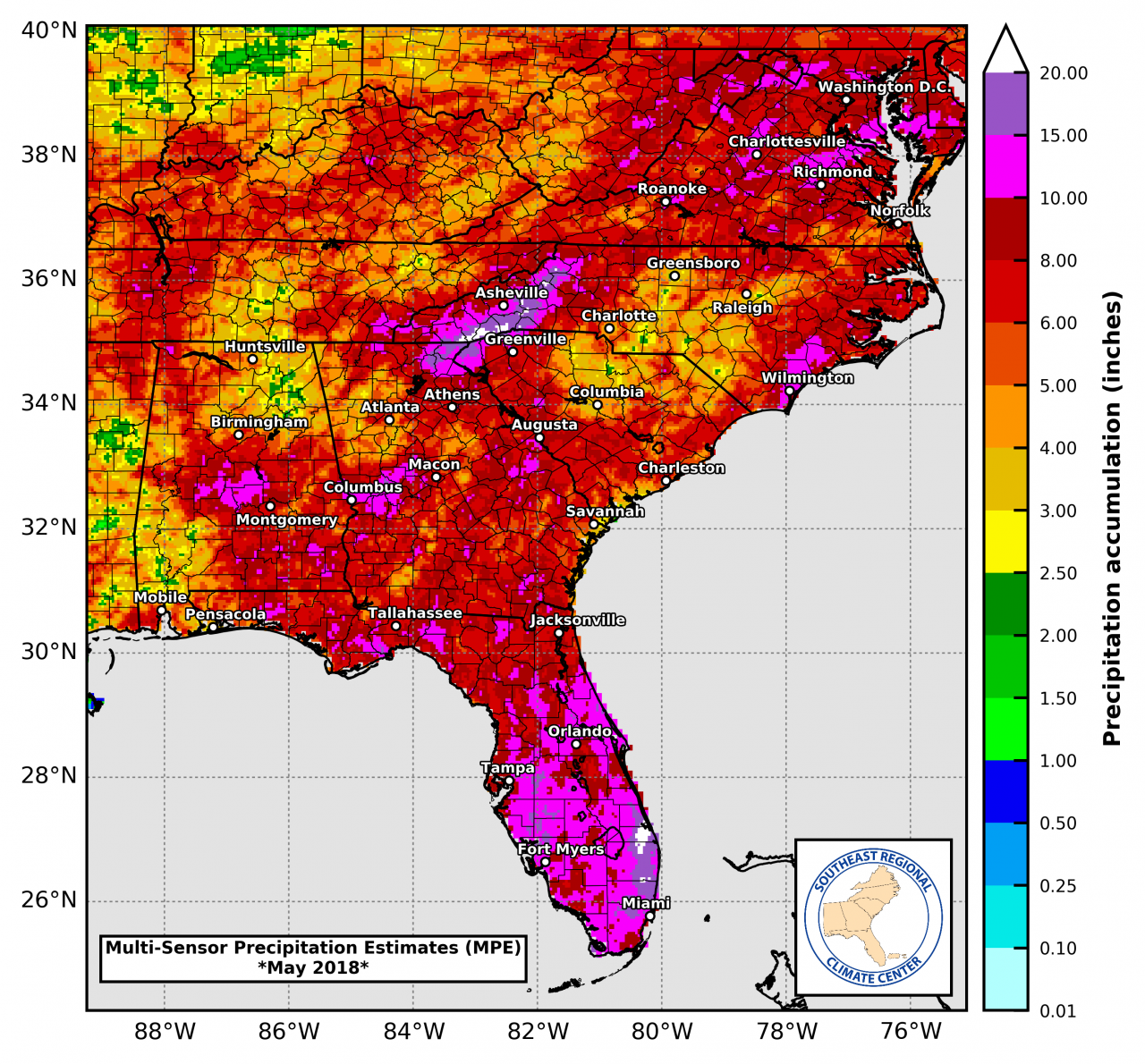
May 2018 rainfall summary. Source SE Climate Center. (click to enlarge)
Rainfall
The weather in May was certainly unique. The month started hot and very dry and ended with rain almost every day, thanks in part to Subtropical Storm Alberto. In the map above produced by the Southeastern Climate Center you can really see Alberto’s impact. The western Panhandle counties did not see much impact from this storm and were much direr for the month. The areas in hot pink received more than 10″ in May, while the western counties in Florida and Alabama in gold or yellow had less than 4″.
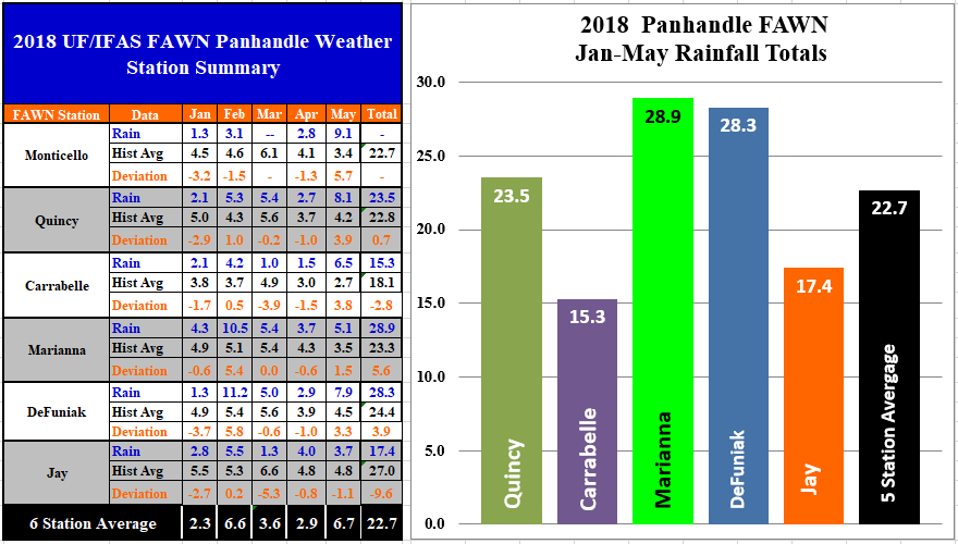 The six Florida Automated Weather Network (FAWN) stations in the Panhandle showed the variation in May rainfall totals. The highest total of 9.1″ was recorded at the Monticello weather station, and the low was 3.7″ in Jay, with an average for all six stations of 6.7″ for the month. Through the first five months of 2018, the five station average (Monticello was down in March) was 22.7″. Marianna has received the highest total of 28.9″ and the lowest total of 15.3″ was recorded in Carrabelle.
 Temperatures
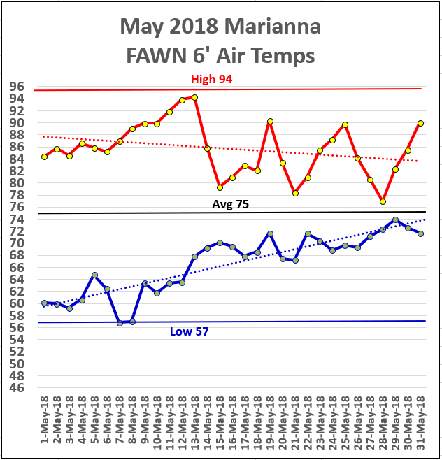
Temperatures heated up quickly in May, as compared to April, and then cooled down with all of the rainy days, but not at night. The high for the month was 94° on May 12 and 13. The low for the month was 57° on May 7 and 8. While the rain did prevent high temperatures in the mid 90s, the nights really warmed up with the tropical air moving in off the Gulf at the end of the month.
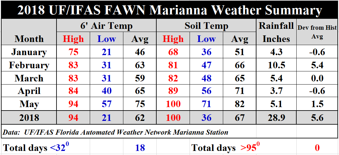 The average air temperature was 75°, which was 10° warmer than the 65° average in April. Soil temperatures rose 11°, from an average of 71° in April to 82° in May. Through the first five months, there were 18 days below freezing, but none above 95° yet, but they came very close. Download the 2018 Jan-May Weather Summary for daily summaries of temperatures and rainfall recorded at the Marianna FAWN station through the first five months of 2018.
Drought
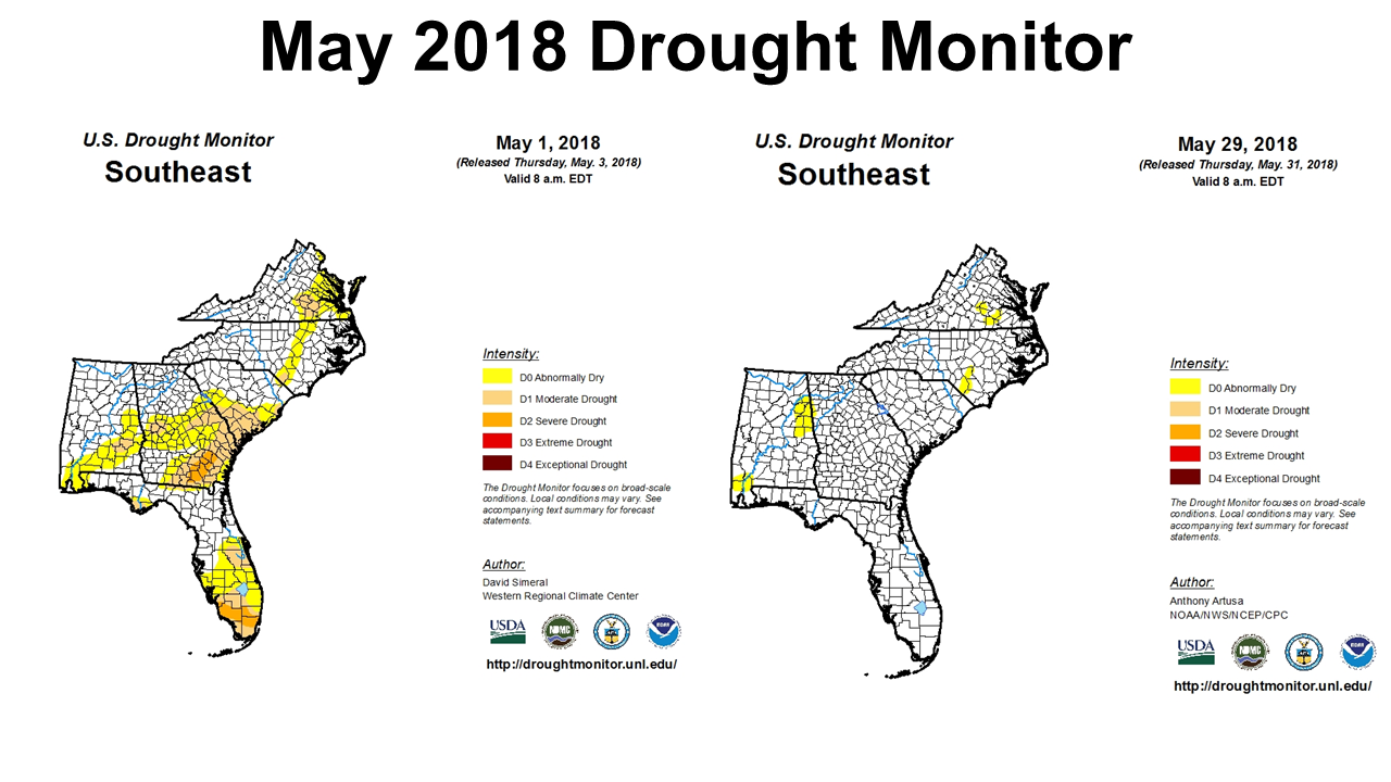 Alberto certainly brought drought busting rains to much of the Southeast. Looking at the Southeast Drought monitor at the beginning and end of May shows the changes that took place. Florida and Georgia are now completely out of the drought categories.
Summer Outlook
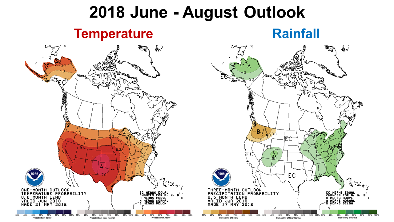 The Climate Prediction Center (CPC) is expecting warmer and significantly wetter than normal conditions across most of the Panhandle and Georgia for June through August 2018. Their forecast line changes for the Western Panhandle Counties and Alabama, with a lower probability forecast for above average rainfall over the next three months. If their expectations are correct, it will be a warm, wet summer which should favor peanut, cotton and corn production, unless we get too much rain all at once.
Bye Bye La Niña
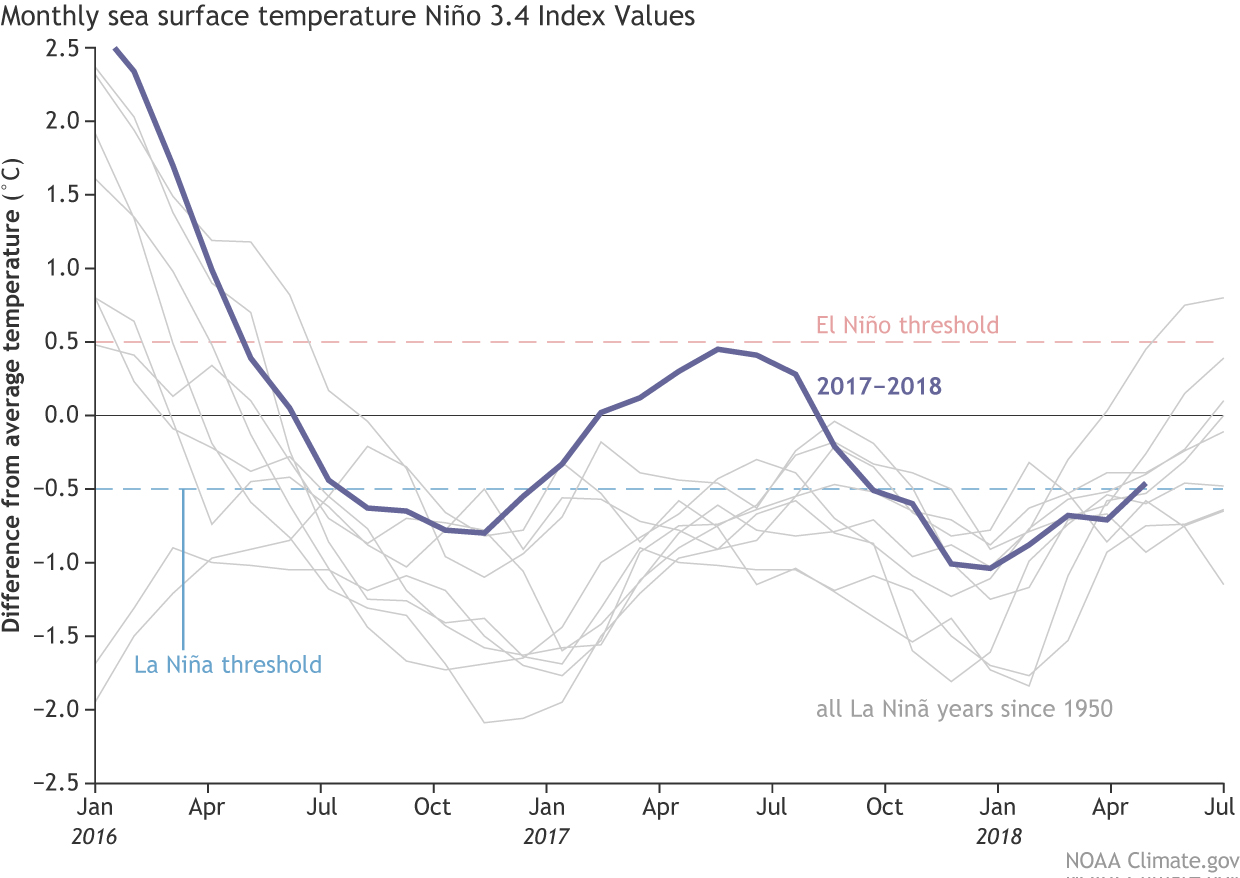 The CPC has officially announced that La Niña has ended. The Pacific Ocean has warmed near enough to normal that we moved back to neutral at the end of April. Neutral conditions are expected through the end of crop season. There is a possibility for a return to El Niño next winter, but it is still too early for forecasters to make that call yet.
As the fall and winter approaches, many models indicate an increasing chance for El Niño. Therefore, the forecaster consensus hedges in the direction of El Niño as the winter approaches, but given the considerable uncertainty in ENSO forecasts made at this time of year, the probabilities for El Niño are below 50%. In summary, ENSO-neutral is favored through September-November 2018, with the possibility of El Niño nearing 50% by Northern Hemisphere winter 2018-19. Climate Predication Center
To look back at weather summaries from previous years, use the following links:
-
2017 Jackson Weather Summary
-
2016 Jackson Weather Summary
-
2015 Jackson Weather Summary
-
2014 Jackson Weather Summary
-
2013 Jackson Weather Summary
-
2012 Jackson Weather Summary
-
2011 Jackson Weather Summary
-
2010 Jackson Weather Summary

demayo@ufl.edu - 850-482-9620
Follow me on Twitter
@UFCowman
- May 2025 Weather Summary and Summer Outlook - June 20, 2025
- Friday Feature:The History of Angus Cattle - June 20, 2025
- Friday Feature:High Quality Legume Hay Production – Virtual Tour of Conrad Farms - June 6, 2025