
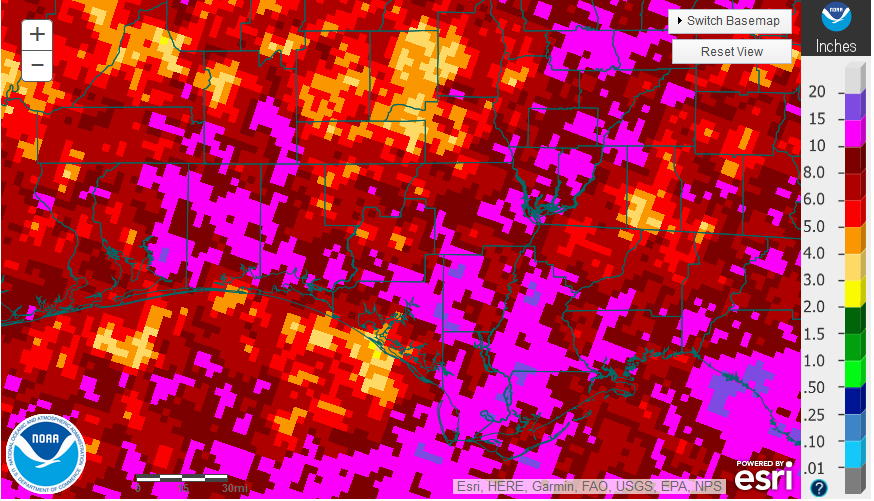
National Weather Service rainfall estimates for July 2018.
Rainfall
July rainfall was above average in many locations across the Panhandle, but this was widely variable. Large areas received more than 10″ (hot pink), while isolated location less than 5″ (light brown).
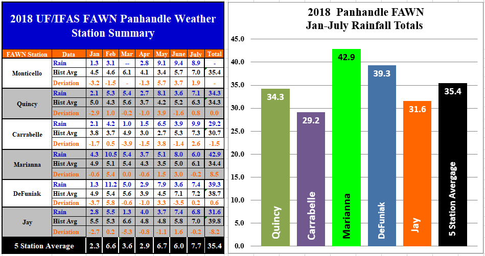 The Florida Automated Weather Network (FAWN) stations showed the variation across the Panhandle. The Carrabelle station recorded 9.9″ of rainfall in July, while only 6″ was recorded at the Marianna Station. Only the Jay and Marianna stations were slightly below historic average for July. For the year the variation is even greater. Jay is -8.2″ below normal, while Marianna is 8.5″ above average. Even with a wet July, the Carrabelle location was still the site with the lowest rainfall totals so far in 2018 at 29.2″. The wettest locations remains at Marianna with 42.9″.
Temperature
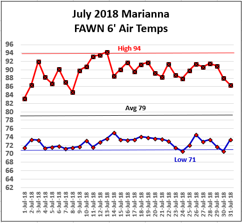 Temperatures in July were fairly similar to June. The high for the month was 94° on July 12 and 13. The low temperature in July never fell below 71° on July 1,4,7 and 24. With so much humidity in the air, it felt plenty hot, but we still have only had one day this year with a 6 foot air temperature above 95°.
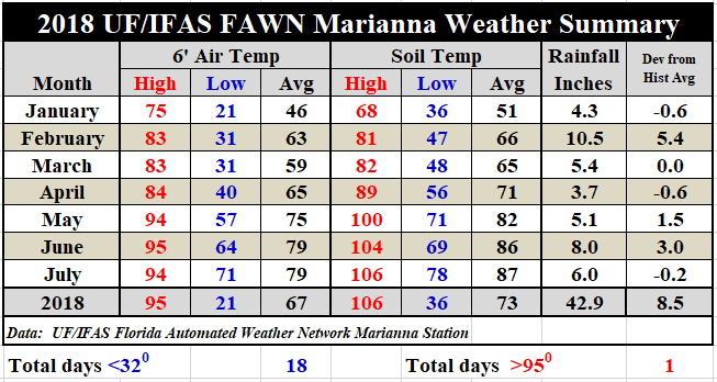
While air temperatures were similar to June with and average of 79°, the soil was slightly hotter, with an average of 87°, as compared to 86° in June. To see the complete record of daily temperatures and rainfall from the Marianna FAWN station, use the following link: 2018 Jan-July Marianna Weather Summary.
August Outlook
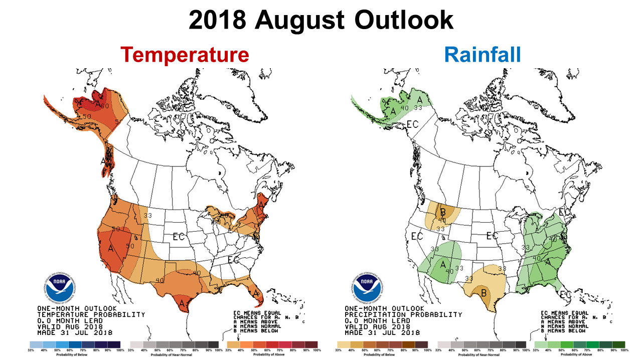 With harvest season just around the corner, many farmers may be getting nervous. The rain keeps coming, and soils are getting saturated. The Climate Prediction Center (CPC) expects the wet summer to continue, with above average chances of higher than average rainfall in August. Temperatures are also expected to remain above average. The CPC’s three month outlook (August-October) exppects average rainfall, so it is possible that the Panhandle may dry out some before harvest, but we all know how the tropics can wreak havoc during those months, so we just have to hope they are right.
El Niño Watch
The CPC has increased the likelihood of the onset of El Niño this fall and winter. The following is an excerpt from the latest ENSO phase forecast.
ENSO-neutral continued during July, as indicated by near-average sea surface temperature. The majority of models predict ENSO-neutral to continue during the remainder of the Northern Hemisphere summer 2018, with El Niño most likely thereafter. Forecasters still favor the onset of El Niño in the coming months, with a ~60% chance of El Niño in the Northern Hemisphere fall 2018 (September-November), increasing to ~70% during winter 2018-19.
What does this mean for farmers? It may well be the best year we have had for winter forages and grain crops since the last El Niño the winter of 2015-16. The past two season have been so dry in the fall, that many farms had difficulty either having enough moisture for a stand, or getting adequate growth for timely grazing. While El Niño years are good for winter forages, they are not as good for spring vegetable crops. It is still really early to know with certainty, but this is the time to order seed for winter forages and small grains. Some winter forage varieties are in short supply, so it is time to roll the dice and decide what to do. The best guess we have at this point, is that there will be better moisture to work with than the previous two seasons.

demayo@ufl.edu - 850-482-9620
Follow me on Twitter
@UFCowman
- May 2025 Weather Summary and Summer Outlook - June 20, 2025
- Friday Feature:The History of Angus Cattle - June 20, 2025
- Friday Feature:High Quality Legume Hay Production – Virtual Tour of Conrad Farms - June 6, 2025