
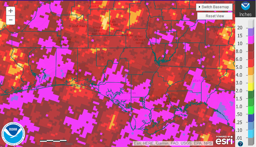
Estimated rainfall for August 2018 prepared by the national Weather Service.
Rainfall
August rainfall was highly variable, but in general above average for much of the Panhandle. Most of the region received 6″ to 10″ (red and dark red), but there were areas that received more than 10″ (hot pink or lavender).
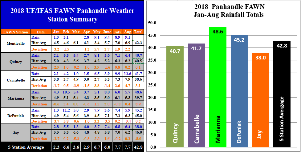 The Florida Automated Weather Network (FAWN) stations showed the variation in rainfall across the Panhandle. The station at Carrabelle recorded 12.6″, while only 5.7″ was recorded at the station in Marianna. Only the DeFuniak station recorded below average rainfall in August. It was not just the total rainfall, but the frequency that impacted farms in the region. There were only 10 days in August that the Marianna station did not record rainfall, which made field work and hay harvest very challenging.
For the year, the Mariana station had the highest eight month total of 48.6″, while the Jay station has only recorded 38″ thus far. All six stations averaged 42.8″ from January through August.
 Temperatures
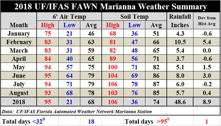
Air temperatures dropped slightly from an average 2′ air temperature of 79° in July to 78° in August. Soil temperatures dropped 2° from an average of 87° in July to 85° in August.
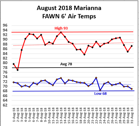 The high temperature of 93° was recorded on August 13, and the low was 68° on August 23. The average for the month was 78°. Believe it or not, the night-time lows are beginning to drop slightly, as the trend-line shows. For a complete report on the daily temperatures and rainfall recorded at the Marianna FAWN station, use the following link: 2018 Jan-Aug Weather Summary.
September Outlook
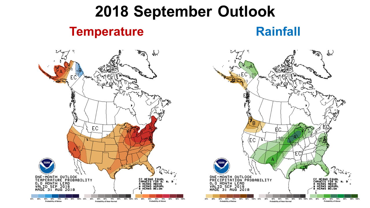 I can only imagine how nervous row crop farmers in the region are becoming, because the rain just keeps coming. Several farmers have mentioned to me that they still remember 2013, which was a challenging harvest year due to continuous rainfall. Unfortunately the Climate Prediction Center (CPC) is expecting the above average rainfall and warm temperatures to continue in September. Certainly Tropical Storm Gordon reminded us how quickly these storms can get organized and strengthen in the Gulf of Mexico. We may have to wait until October for dry harvest conditions.
El Niño Watch
The CPC has slightly increased the likelihood of an El Niño winter, but it is not much different than outlook reported last month.
ENSO-neutral conditions are present. Equatorial sea surface temperatures are near-to-above average across most of the Pacific Ocean. There is ~60% chance of El Niño in the Northern Hemisphere fall 2018 (September-November), increasing to ~70% during winter 2018-19. Climate Prediction Center

demayo@ufl.edu - 850-482-9620
Follow me on Twitter
@UFCowman
- Making the Most of High Cattle Prices – Grow More of Your Own Feed - July 18, 2025
- Friday Feature:1960 Corn Farmer - July 18, 2025
- June 2025 Weather Summary and Three-Month Outlook - July 11, 2025