
Rainfall
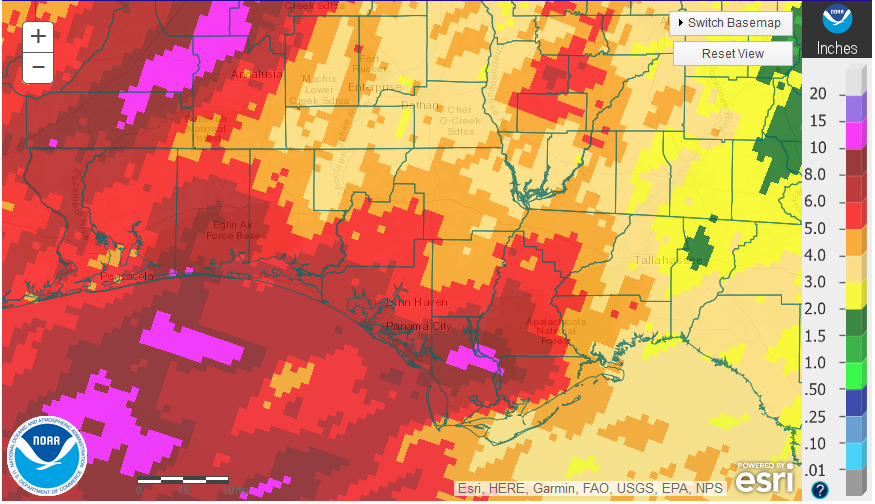
April was another dry month in the central and eastern portion of the Panhandle, with higher totals in the western counties. The areas in red received over 5″, while the tan, yellow and green less than 4″.
 –
–
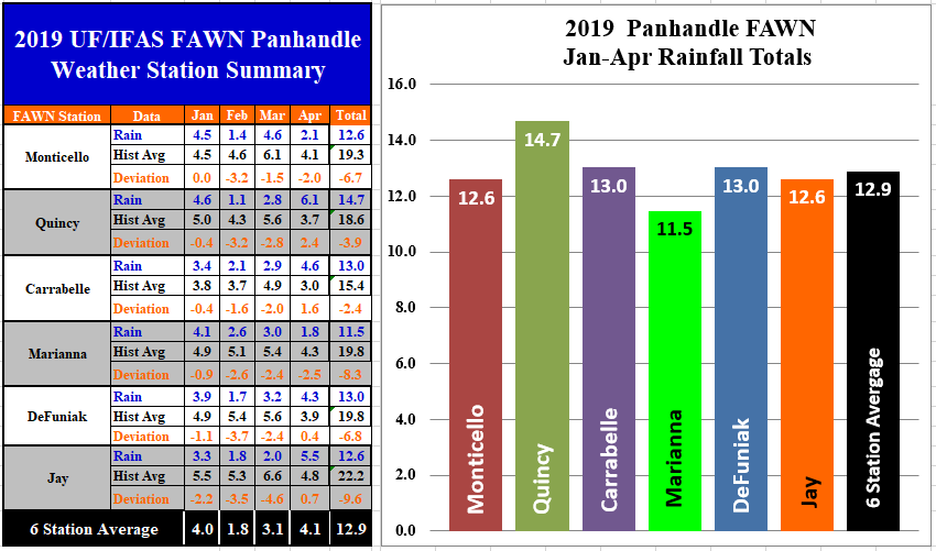
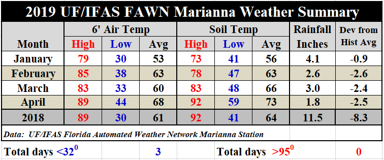
The Florida Automated Weather Network (FAWN) Stations also showed the variation in April rainfall across the Panhandle, ranging from only 1.8″ in Marianna to 6.1″ in Quincy. Only the Marianna (-2.5″) and Monticello (-2″) stations recorded below historic averages for the month. This data really shows how the recent cold fronts did not provide uniform rainfall across the Panhandle in April.
Through the first four months of 2019, all 6 locations have received less than historic average. The low total of 11.5″ was recorded in Marianna, and the highest total of 14.7″ was recorded in Quincy. The average of all six locations was 12.9 inches through the first third of the 2019, which is more than 6″ below normal for the region.
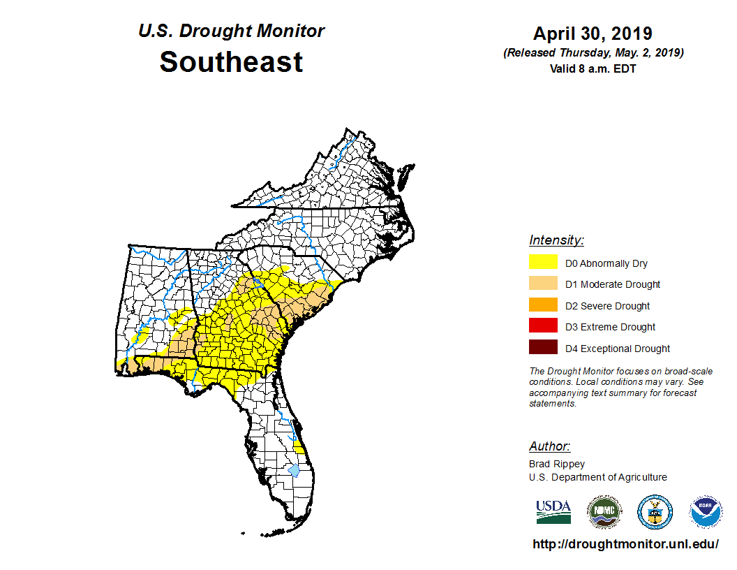
The Southeastern drought monitor still shows moderate drought, or abnormally dry conditions across much of the peanut belt. At the end of April, portions of Escambia, Santa Rosa, Okaloosa, and Holmes counties were included in the D1 Moderate Drought category. This is especially challenging at planting time for cotton, peanuts, and soybeans.
Temperature
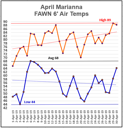
The air and soil temperatures warmed up rapidly through April 2019. The high for the month of April was 89° on April 29, with a low of 44° on April 3.
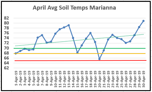
Soil temperatures have definitely warmed up enough for peanut and cotton planting, as the average soil temperature has been above 70° since April 22.
Through the first third of 2019, there has been a steady increase in temperatures. There were only five days this winter below freezing from November 2018 through April 2018, with a low of only 30°. Farmers can expect higher populations of insects and nematodes after such a mild winter. For a complete listing of daily temperature and rainfall statistics for the Marianna FAWN station, use the following link: January – April 2019 Weather Summary
May Outlook
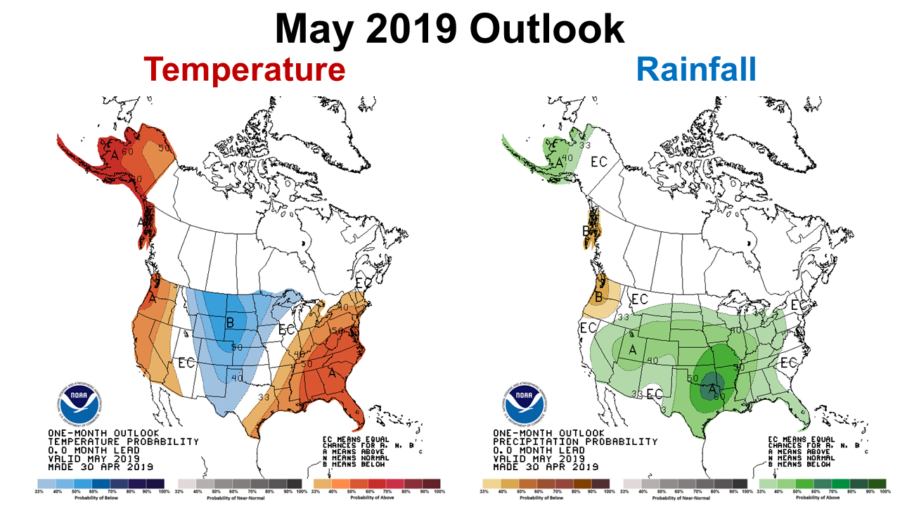
The Climate Prediction Center (CPC) is expecting May to be warmer than normal, but with above average rainfall. However, their predictions have not held true through the first four months, so let’s hope they are right this time. I am sure part of the influence for the continued expectation for above average temperatures and rainfall stems from the El Niño affect on the Southeast. The 2018-19 El Niño has provided a boost to rainfall in Texas, Oklahoma, Louisiana, and Mississippi, but has not carried as well across the Southeast. The precipitation outlook map does show a greater affect is expected in those states again in May.
El Niño Watch
The latest CPC report predicts that the current weak El Niño will carry through summer, and may even last into this fall.
El Niño is present. Equatorial sea surface temperatures (SSTs) are above average across most of the Pacific Ocean. The pattern of anomalous convection and winds are consistent with El Niño. A weak El Niño is likely to continue through the Northern Hemisphere summer 2019 (65% chance) and possibly fall (50-55% chance). NWS Climate Prediction Center
May is a significant month for farming and ranching in the Panhandle. The days are lengthening and it has certainly been warm enough for optimal seed germination for crops of all types. The only thing missing for a fast start to this farming season has been moisture for much of the region. Let’s hope the CPC’s predictions are right and that May rains will be more uniform than in the previous month. I would suggest paying close attention to short-term weather forecasts to plant with anticipated moisture, if possible. May is typically one of the driest months of the year, so a forecast for above average rainfall may not amount to a significant change from April.

demayo@ufl.edu - 850-482-9620
Follow me on Twitter
@UFCowman
- May 2025 Weather Summary and Summer Outlook - June 20, 2025
- Friday Feature:The History of Angus Cattle - June 20, 2025
- Friday Feature:High Quality Legume Hay Production – Virtual Tour of Conrad Farms - June 6, 2025