
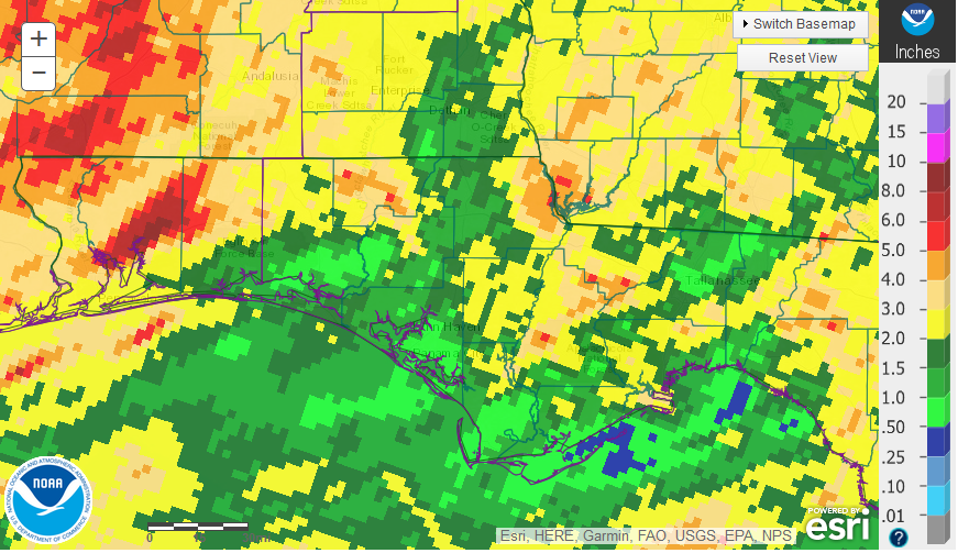
Rainfall
After abundant rainfall at the end of 2018, 2019 has gotten drier and drier for much of the Panhandle. Not only was it dry, but extremely hot as well. In the graphic above, generated through the National Weather Service data, there were isolated areas of the region that received more than 4″ in May (tan and red), but most of the Panhandle received less than 3″, (yellow and green) for the month.
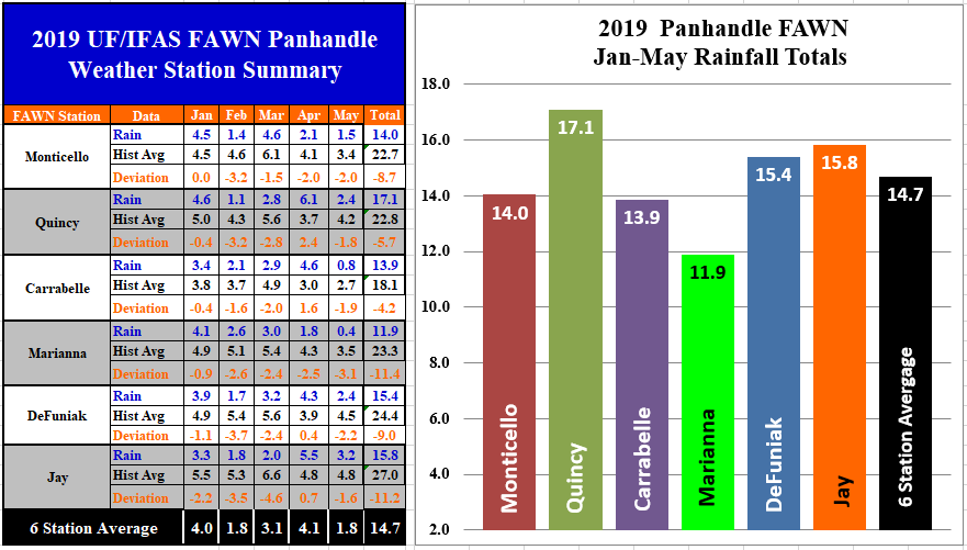
The Florida Automated Weather Network (FAWN) documented the variation in rainfall in May 2019. The direst location was at Marianna with only 0.4″, which was 3.1″ below average. In Jay, 3.2″ were collected, which was still 1.6″ below average at that location. All six stations were 2-3″ below historic average. The average for all six FAWN stations was 1.8″, which is 2.1″ below average for the group.
Through the first 5 months of 2019, The driest location was in Marianna. The 11.9 inches collected was 11.4″ below historic average, and set the record for the lowest January-May cumulative total in the 68 years of rainfall records at that location. The previous low was 11.98″ in 1954. The station in Quincy has recorded 17.1″ thus far in 2019, which was still 5.7″ below average for that location. The average for all 6 locations was 14.7″, which was 8.4″ below historic average for the group.
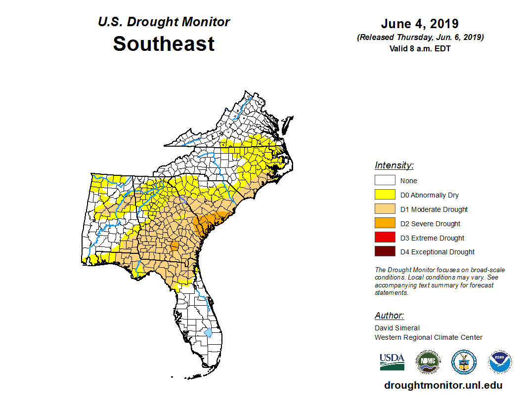
Not surprisingly almost the entire Panhandle is now in the abnormally Dry (D0) or Moderate Drought (D1) categories. You can see that the entire Peanut Belt in the Southeast is suffering from short term drought.
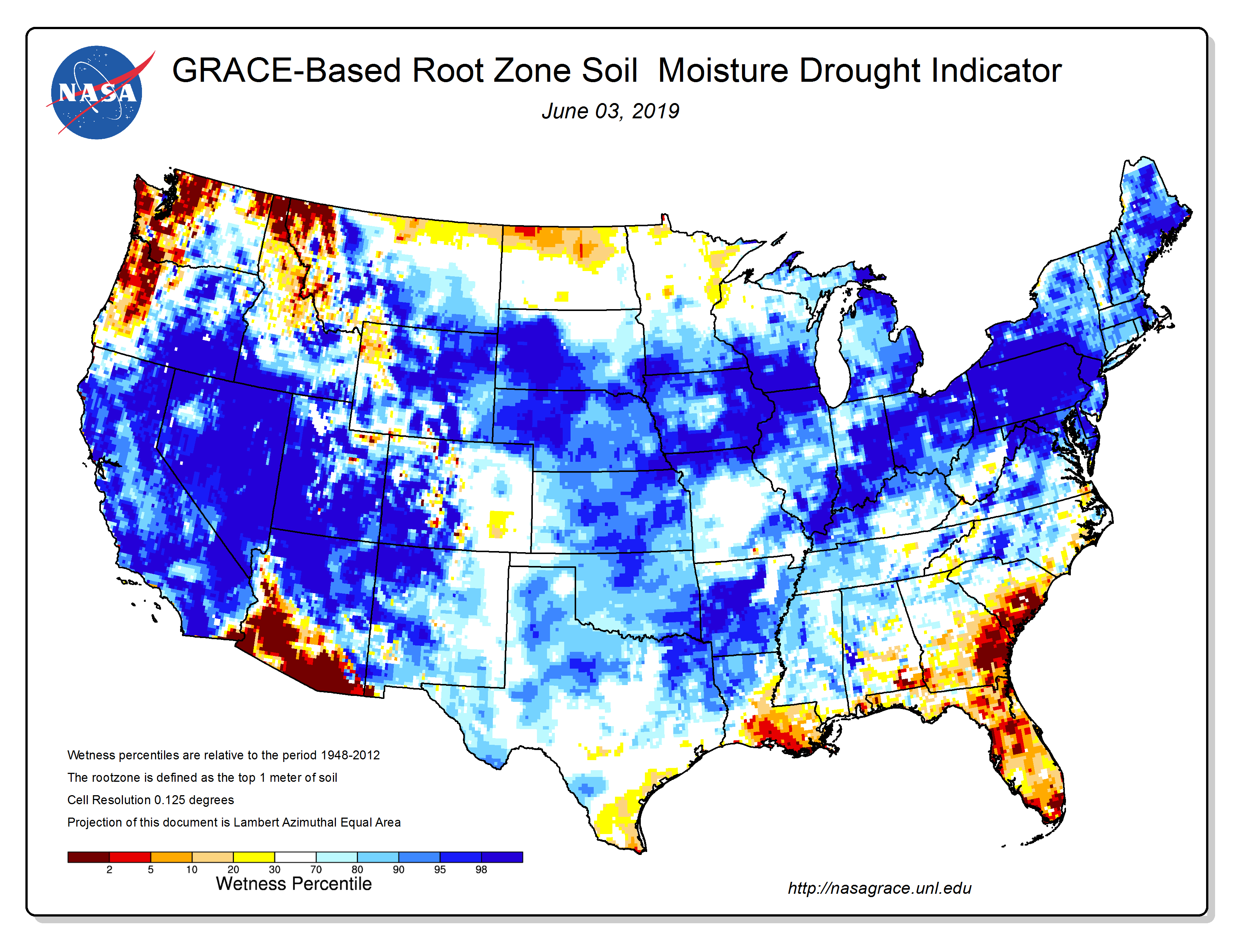 Another tool being utilized for drought monitoring is the NASA Root Zone Soil Moisture map. With this map the you can really see the variation in soil moisture between the Southeast, that has been so dry as compared to the Midwest, where fields are so wet farmers are struggling to plant corn and soybeans on time.
Temperatures
There was significant temperature variation of 42° in May, ranging from the low of 56° on May 15 to a high of 98° on May 25, 26, and 29. There were seven days in May with high temperatures above 95°, as compared to only six days with measurable rainfall. Soil temperatures were even hotter at the end of May, reaching a high of 103° on May 25.
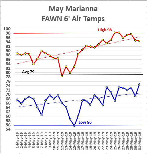
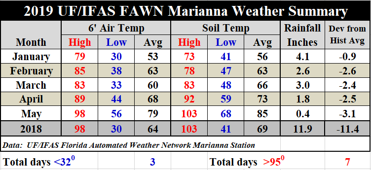
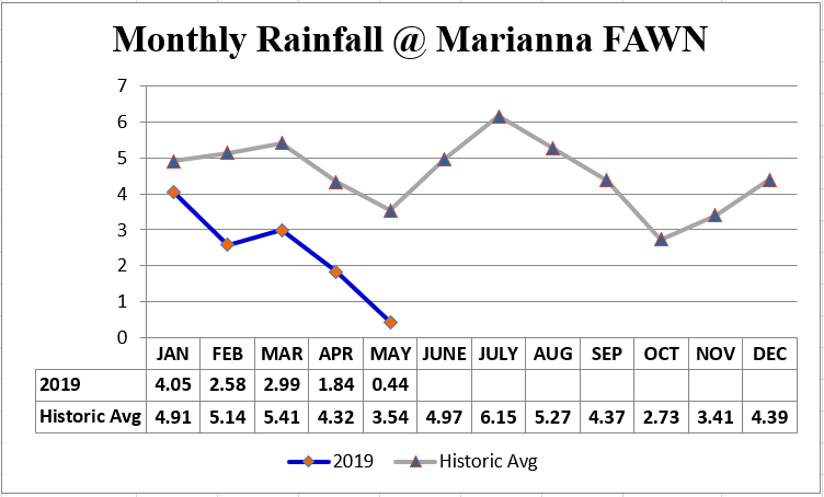
In comparison with April, the average air temperature rose 11°, from 68° to 79°. Average soil temperatures rose 12°, from73° in April to 85° in May. For a complete daily weather summary recorded at the Marianna FAWN station, use the following link: January – May 2019 Weather Summary
June Outlook
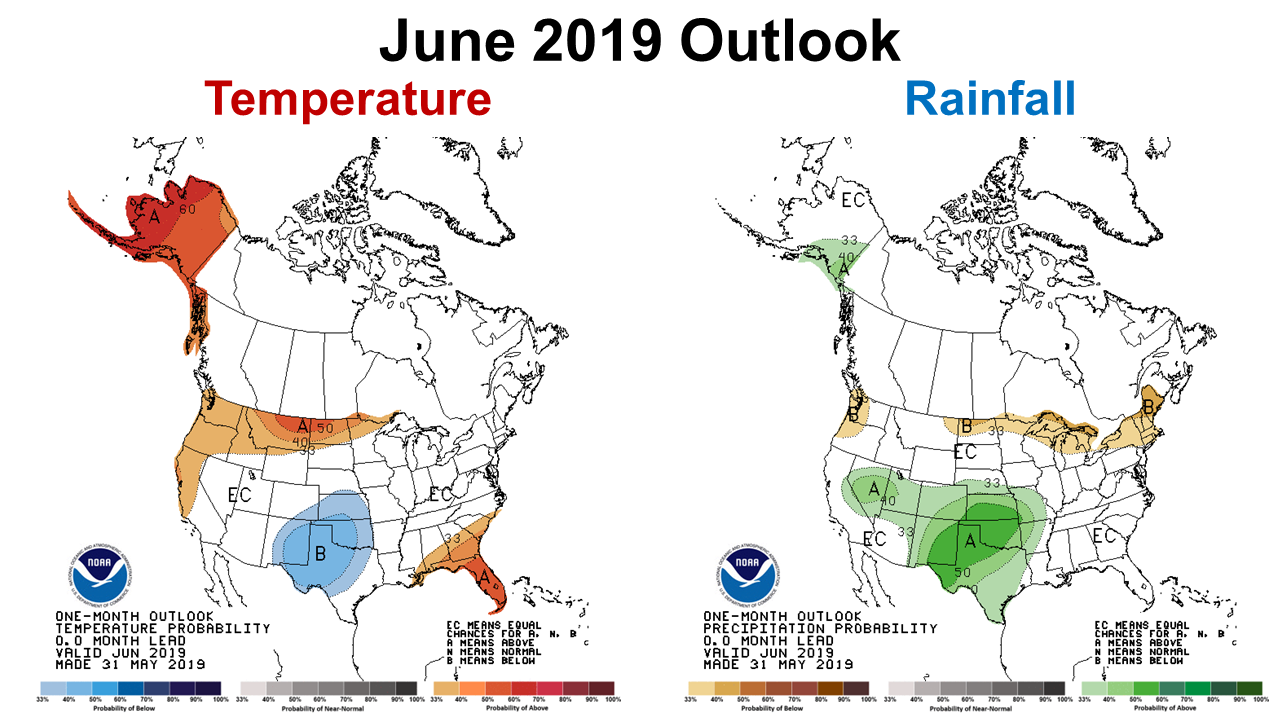
For the first time this year, the Climate Prediction Center (CPC) future outlook has not forecast above average rainfall across the Southeast. There were wrong the other 5 months, so it makes sense for them to issue the equal chances (EC) forecast for this region in June. They are still predicting above average temperatures to continue all across Florida.
El Niño Watch
The CPC is still reporting that El Niño conditions are expected to continue throughout the summer, and quite possibly through the fall.
El Niño is present. Equatorial sea surface temperatures (SSTs) are above average across most of the Pacific Ocean. The pattern of anomalous convection and winds are consistent with El Niño. El Niño is likely to continue through the Northern Hemisphere summer 2019 (70% chance) and fall (55-60% chance). Climate Prediction Center
After a really hot and dry start to the year, these forecasts don’t offer much assurance that things will improve for the Southeast in the near future. The El Niño That was expected to increase rainfall in the Southeast certainly has not. One thing I have learned from listing to climatologist discussions of past ENSO phases (El Niño/ La Niña) is that their associated affects vary for different portions of the country each time. Clearly this was a year when the Midwestern States received the most influence from the El Niño instead of the Southeast. At least with the recent breakup of the high-pressure dome over the Southeast, we should have the opportunity for more normal summer rainfall in the near future. Let’s hope the drought ends in June, so pastures and crops can get back to growing again. The rain at the end of the first week of June could certainly jump-start a more normal rainfall pattern.

demayo@ufl.edu - 850-482-9620
Follow me on Twitter
@UFCowman
- May 2025 Weather Summary and Summer Outlook - June 20, 2025
- Friday Feature:The History of Angus Cattle - June 20, 2025
- Friday Feature:High Quality Legume Hay Production – Virtual Tour of Conrad Farms - June 6, 2025