
 Rainfall

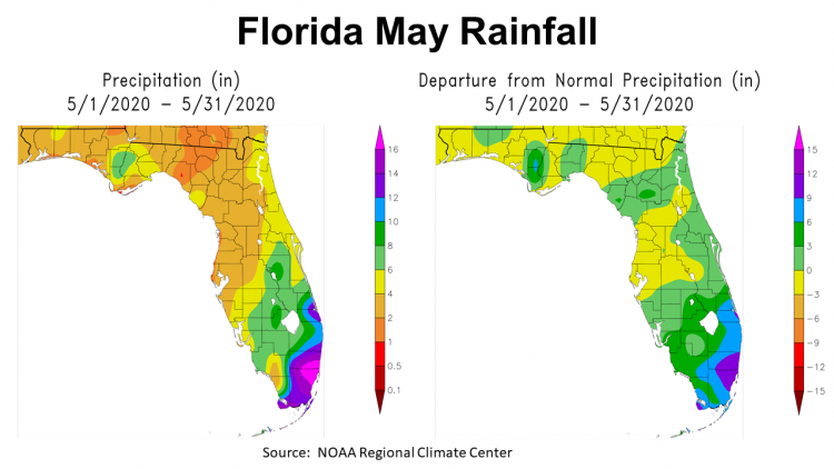
May was a more typical month than others have been lately, but that was not a good thing. It was not as hot as typical, but it was certainly dry. In the map to the left above, you can see that other than Calhoun, Gulf, and Liberty Counties, most of the Panhandle received 1-4″ of rain in May 2020. Along the Apalachicola river (area in green) 6-8″ of rain fell. The map to the right above shows the departure from normal rainfall. The pockets of green and blue were the only areas that were above average for the month.
–
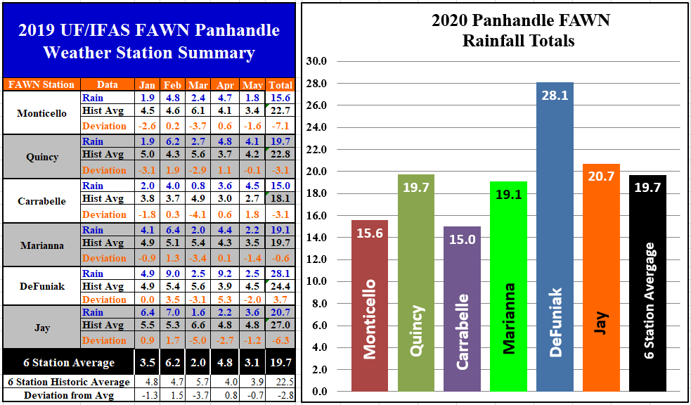
The University of Florida’s Florida Automated Weather Network (FAWN) stations did not capture the full range as depicted in the NOAA Regional Climate Center Maps above, because there are no FAWN stations located in the areas that had higher rainfall totals. Of the six stations, the Carrabelle station had the highest total in May, with 4.5″ recorded, and was the only location above historic average.. The driest location was in Monticello, with only 1.8″ for the month. The average of all six locations was 3.1″, which was -0.7″ below normal. Through the first 5 months of 2020, the DeFuniak station has recorded 28.1″. The DeFuniak Station was the only one that has recorded above historic average rainfall so far in 2020. Even with the higher total in May, the Carrabelle station had the lowest total of 15″ thus far this year. The six-station average through 5 months is 19.7″, which is -2.8″ below normal.
–
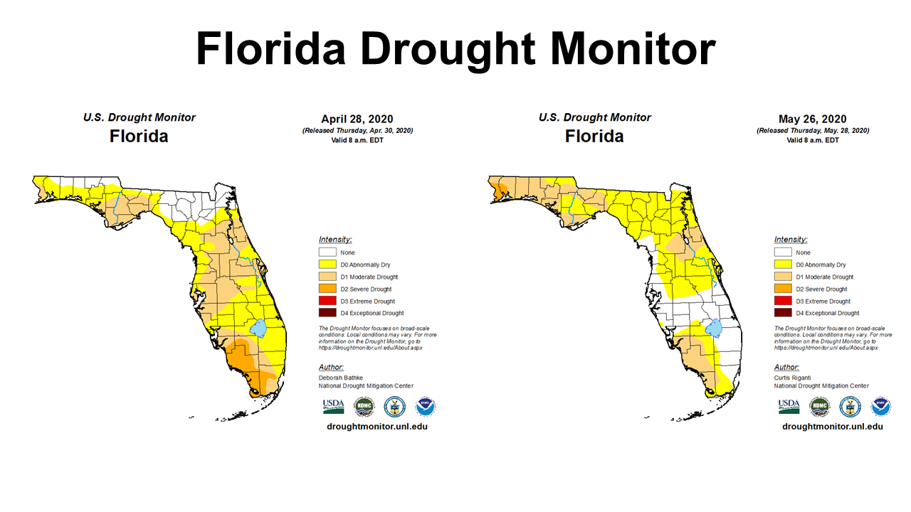
The Florida Drought Monitor comparison above shows the changes from the end of April through the end of May. While there were improvements in central and southern Florida, drought conditions continued to worsen across North Florida. Portions of Escambia and Santa Rosa Counties were in the Severe Drought category at the end of the month.
–
Temperatures
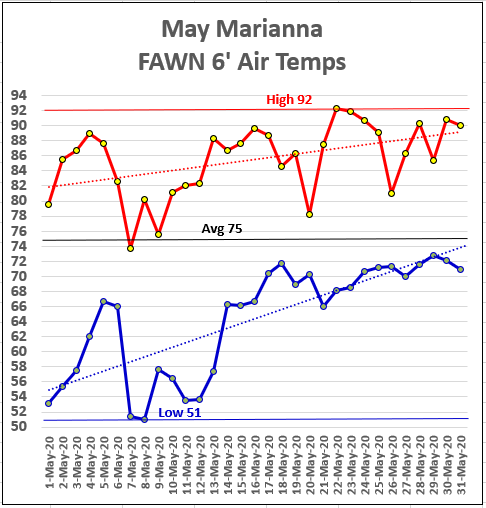
May 2020 was pretty strange, temperature wise, with a 41° spread in a single month. Most agreed it is was refreshing, but 51° on May 7 & 8 was definitely a surprise. No it was not a record low (47°), but it has been some time since we enjoyed low 50s in May. Of course, it did not last long as temperatures rose to 92 on May 22 and 23. The average for the month was 75°, which was slightly warmer than 73°, the historic average for May in Marianna.
–
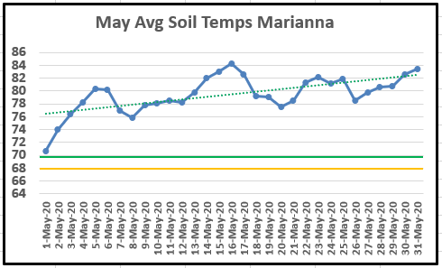 Even though there was a short term cool down in May, the soil temperatures really did not fluctuate too drastically. The green line at 70° is the recommended minimum temperature for immediate peanut seed germination. On May 1, the average soil temperature was 71°, but it warmed substantially through the month.
–
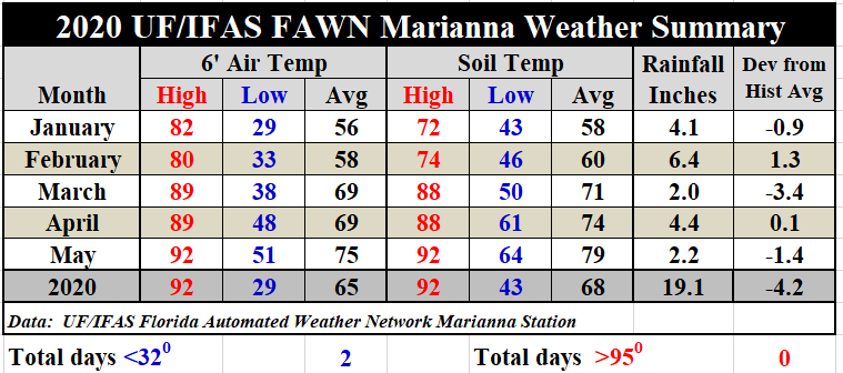
As compared to April, the average 6′ air temperature was 5° warmer in May, climbing from 69° to 75°. Average soil temperatures rose from 74° in April to 79° in May. A complete daily weather summary from the Marianna FAWN station, and monthly precipitation summaries from all six stations in the Panhandle are available in the following publication: January-May 2020 FAWN Weather Summary
–
 Summer Outlook
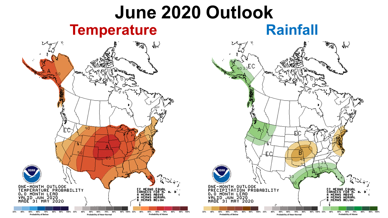
The Climate Prediction Center (CPC) is forecasting hot and rainy conditions to continue in June. No real surprise there, but it it is positive to see the green, above average rainfall forecast all across the Gulf Coast for a change.
–
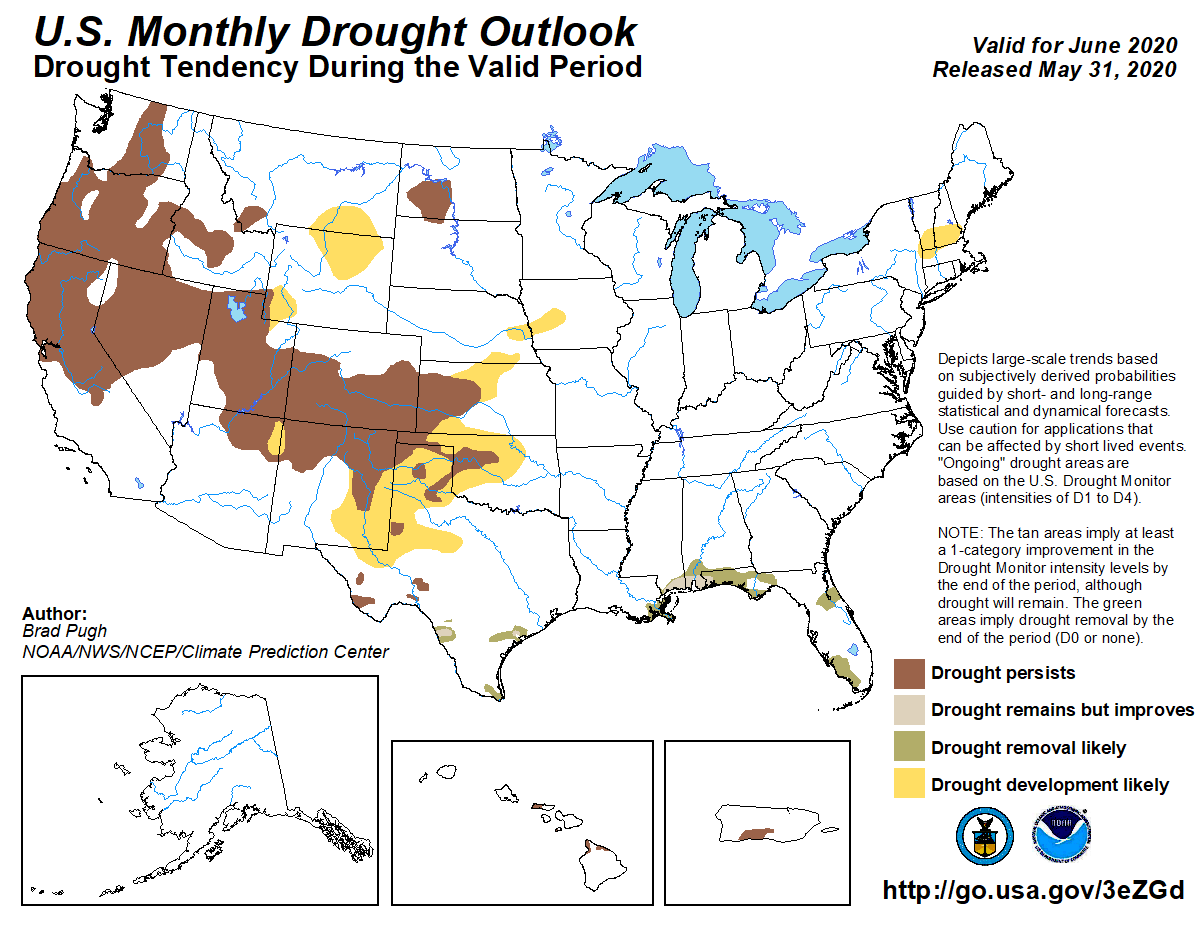 More good news follows this current outlook forecast. The CPC is expecting June rainfall to drastically improve drought conditions along the Gulf Coast.
–
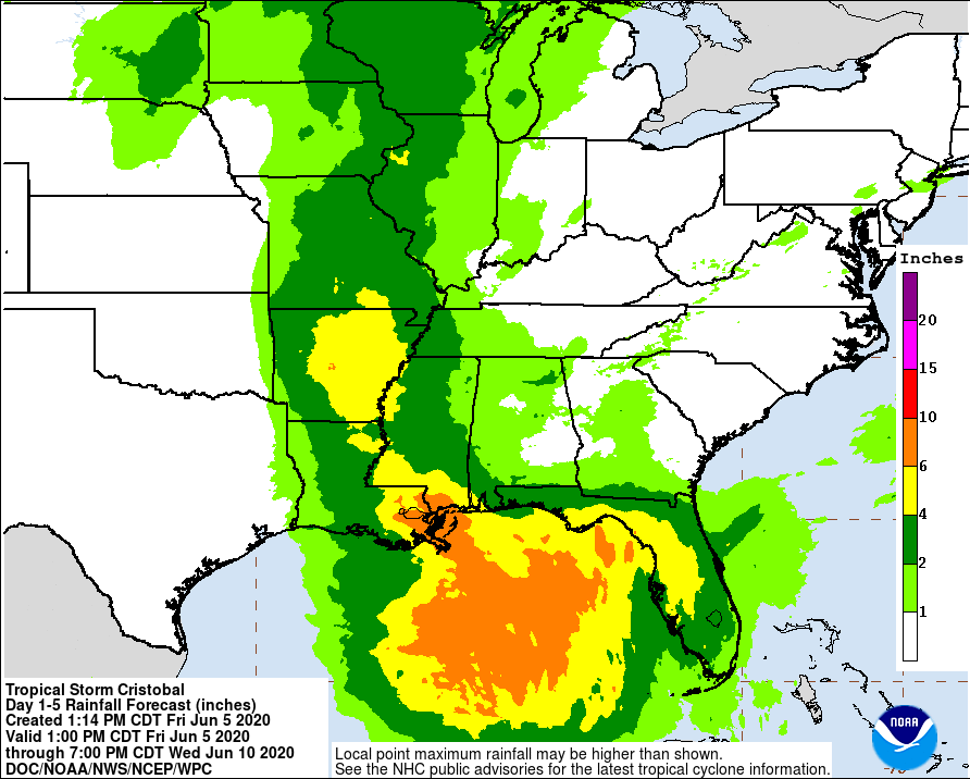 I can only imagine that Tropical Storm Cristobal will improve the drought situation for several areas that have been in extended drought. The map above shows the rainfall totals the National Hurricane center is forecasting from Cristobal. Most of Florida is expected to get 2-6″ this weekend. That could build some soil moisture in areas that have been slighted for the past several months. While no one along the Gulf coast likes to hear a tropical system is passing through, 2-3″ could be beneficial, especially in Escambia and Santa Rosa Counties.
–
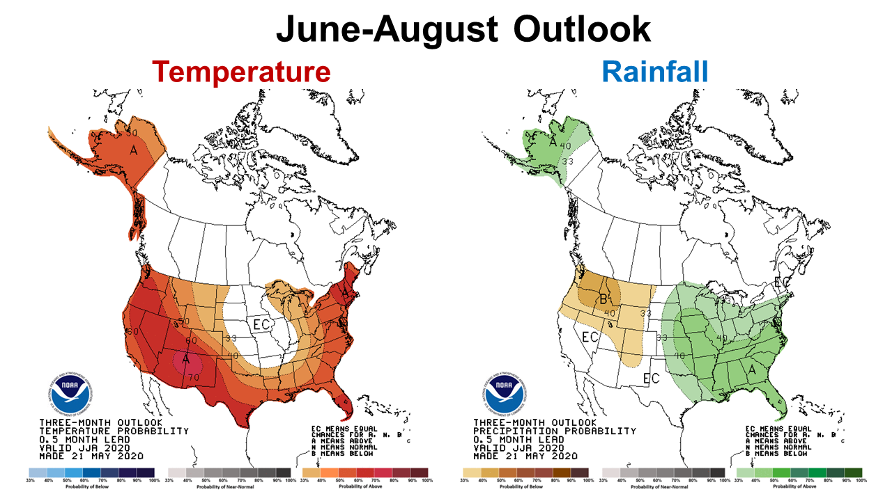 The longer ranged, 3-month CPC outlook is also very positive, as far as above average rainfall for the summer months. But, you can’t always get what you want, so it will likely be very hot too.
–
So what does this mean for farmers and ranchers in the Panhandle?
The current outlook and forecasts for the summer look pretty positive. It does appear that after a dry start to the growing season, the drought conditions should improve over the next three months. Experts at the CPC have increased the possibility of a La Niña this fall (45% chance), so it may get dry again this fall, but as of right now the highest probability is to remain neutral. Maybe we will have a better growing season than was originally anticipated? Certainly it has been a rough start for crops and forages, so above average rainfall sounds pretty good for a change. If there extra rainfall, don’t let weeds get off to a fast start before controlling them. This could also be a year that round bale silage is a wiser choice than hay, at least for the next few months. It is also not too late to plant summer annual forages or permanent pastures. In general, you want perennial forages in the ground before the end of July to store up energy for the winter ahead.
Check back next month, and I will share the final results of June weather, but it looks encouraging, as long as Cristobal moves through quickly, and does not have many siblings that follow after him. We know too well what fall storms bring. I will keep checking on a La Niña forecast. Hopefully, that will not come to pass, as it generally means a dry fall and winter in the Florida Panhandle.

demayo@ufl.edu - 850-482-9620
Follow me on Twitter
@UFCowman
- May 2025 Weather Summary and Summer Outlook - June 20, 2025
- Friday Feature:The History of Angus Cattle - June 20, 2025
- Friday Feature:High Quality Legume Hay Production – Virtual Tour of Conrad Farms - June 6, 2025