
 Rainfall
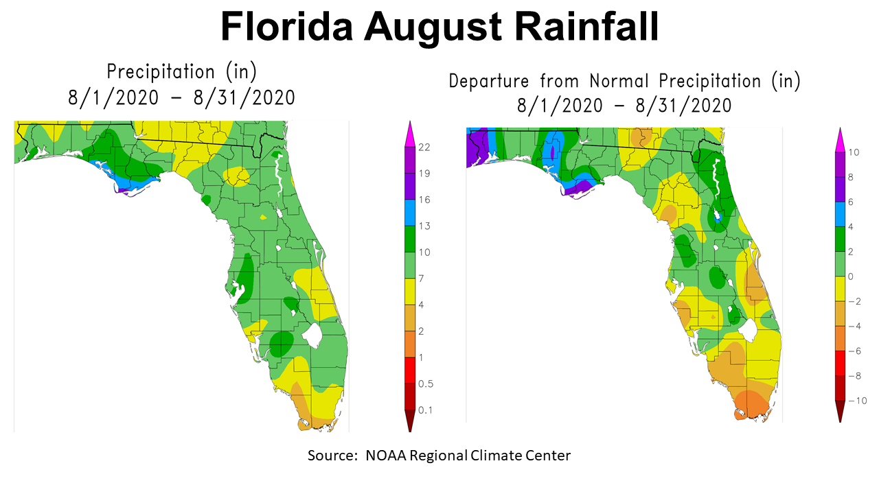
August 2020 was a wet month for much of the Panhandle Region, but not everywhere. In the map above to the left, you can see rainfall estimates for August 2020 across Florida. While there were areas that had more than 13″ (blue and purple) the areas in yellow received 4-7″ in the month of August. The map to the right shows departure from normal. Shaded sections in yellow and tan were below normal, while the areas in green, blue or purple where above historic average for the month.
–
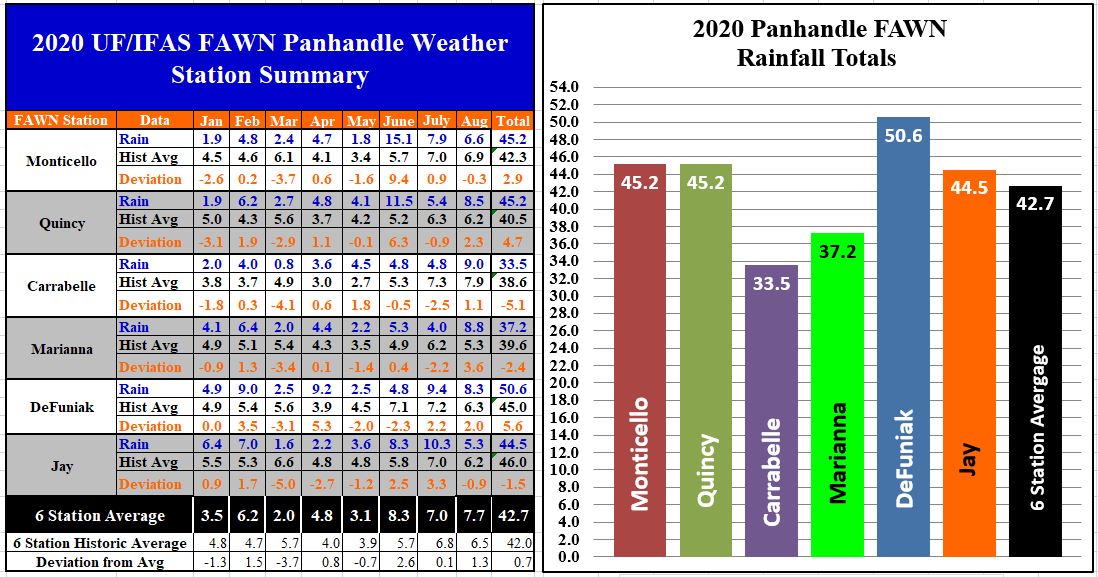
The data from the six Florida Automated Weather Network (FAWN) station in the Panhandle shows the wide variation recorded in the region. The highest total for the month of August was 9.0″ in Carrabelle, while only 5.3″ was recorded in Jay. The stations at Monticello (-0.3″) and Jay (-0.9″) were the only stations below historic average for the month of August. The average rainfall for all six stations was 7.7″, which was 1.3″ above normal .
Through the first eight months of 2020, the driest location was still Carrabelle, with only 33.5″, while a total of 50.6″ has been recorded at the station in DeFuniak Springs. Three stations, Carrabelle, Marianna, and Jay were below historic average through eight months. The average of all six stations was 42.7″, 0.7″ above normal.
–
 Temperatures
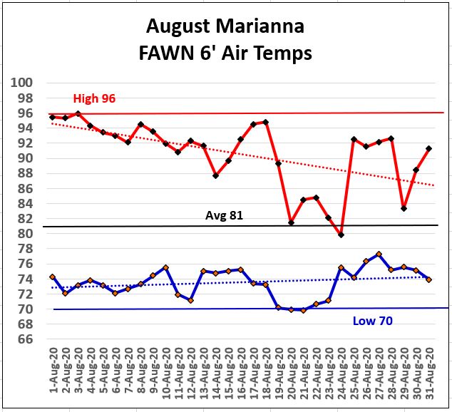
The six foot air temperatures recorded at the Marianna FAWN Station show that day time high temperatures cooled as we moved through the month with 17 days of measurable rainfall in the month. The high for the month of 96° was recorded on August 3rd, but there were only three days over 95°, which were the first three days of the month. The low for the month was 70° on the mornings of August 19-21. Not since June 19 (73 days), have we had morning temperatures in the 60s. Fall is coming, but it is not here yet.
–
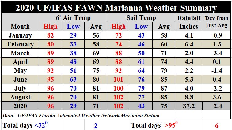
The average air temperature remained unchanged at 81°, compared to July. The average soil temperature did drop slightly, from 87° in July to 85° in August. Overall though there have only been six days with high temperatures over 95° thus far in 2020. Use the following link to download the daily precipitation and temperatures from the Marianna FAWN station, and monthly rainfall records from all six FAWN stations in the Panhandle: January-August 2020 Panhandle FAWN Weather Summary
–
Harvest Season Outlook
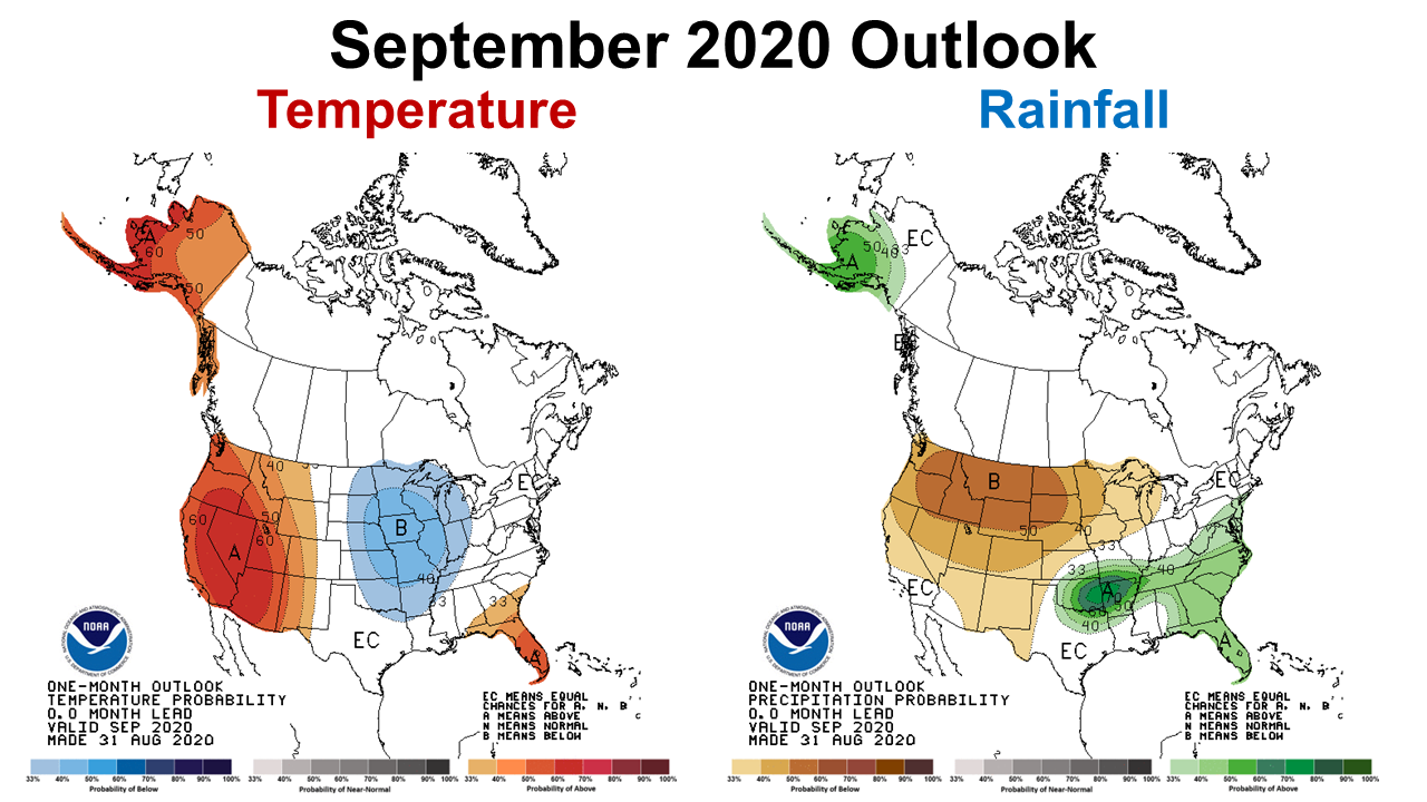 For the month ahead, the Climate Prediction Center (CPC) is expecting September to remain warm (66% chance) and wet 66-70% chance across the Panhandle, but is less confident of above average rainfall in the Western Counties (66% chance). Basically the current trend is predicted to continue in September, so it may still be a while before we have 60° low temperatures again.
–
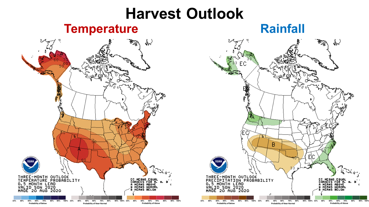 The harvest season CPC outlook (September – November) also predicts 73% chance of above average temperatures and a 66% chance of higher than normal rainfall through November.
–
La Niña Watch
The CPC is still expecting the sea surface temperatures to drop over the next three months and make the switch from ENSO Neutral to La Niña. But they are sitting on a 60% forecast, so they are still not convinced. If you read through the CPC’s monthly ENSO phase discussion, their prediction models are split between ENSO Neutral to La Niña.
ENSO-neutral conditions are present. Equatorial sea surface temperatures (SSTs) are near-to-below average across the central to eastern Pacific Ocean.The tropical atmospheric circulation is consistent with ENSO-neutral.There is a ~60% chance of La Niña development during Northern Hemisphere fall 2020 and continuing through winter 2020-21 (~55% chance).
–
What does this mean for farmers and ranchers?
For the most part, 2020 has been a growing season with more rainfall than in recent years, but there has been considerable variation. Some areas are so wet, farmers are nervous about the upcoming harvest of peanuts and cotton. Many corn producers have already experienced delayed harvests because of the frequent afternoon rains. The CPC expects above average rainfall over the next three months. However, average rainfall for Marianna is 2.8″ in October and 3.4″ in November, so above average might not mean too wet to harvest. In the areas that are already saturated, wet fields could be an issue. The warmer than normal prediction could mean delayed first frost, but not necessarily. The CPC outlooks just give general trends of what to expect, not weekly forecasts.
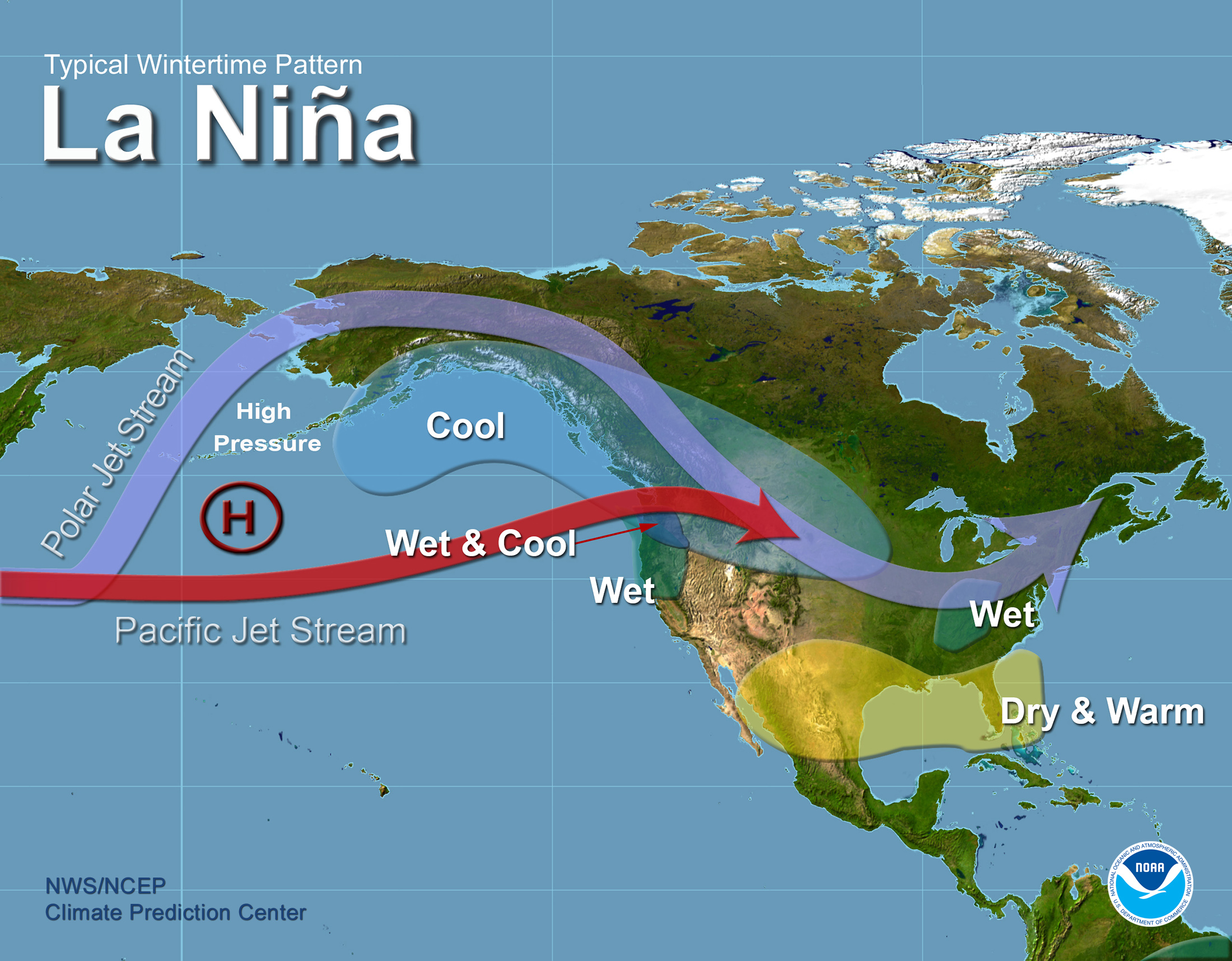
Typically ENSO climate affects are the greatest in the fall and winter. Looking a little further on decisions for small grains, winter forage, and cover crops, the graphic above shows the general trend in La Niña winters. Along the Gulf Coast La Niña indicates warmer and drier than normal winters. However, when you look back at past La Niña winters there has been variation, based on the degree of cooling that takes place in the Pacific, so each season may be weak, average, or strong. Since the CPC is still only saying a 60% chance of La Niña. I would call that more of a lean than a definite forecast, and tells me they are not ready to pull the trigger on declaring a La Niña.
It is hard to know at this point how much influence the ENSO phase will actually have on the climate of winter of 2020-21. This is why climate forecasters give general guidelines, but not specific forecasts. The best guess is to prepare for a drier than normal winter. That means the earlier that you can plant winter crops the better. It also means that ranchers should focus on planting fields with better moisture holding capacity, and invest in clean-tilled fields as compared to over-seeding existing pastures. We have good soil moisture now, which should continue at least through September, so October plantings may have an even greater advantage to November plantings than normal. With low cattle prices and tight margins, it will be even more important to make wise investments for winter grazing in your best, most productive fields this year. But there is still not clear evidence yet to make the deceleration. Stay tuned to see what they are thinking towards the end of September to see if the CPC gives more certain guidance.

demayo@ufl.edu - 850-482-9620
Follow me on Twitter
@UFCowman
- May 2025 Weather Summary and Summer Outlook - June 20, 2025
- Friday Feature:The History of Angus Cattle - June 20, 2025
- Friday Feature:High Quality Legume Hay Production – Virtual Tour of Conrad Farms - June 6, 2025