
 Rainfall
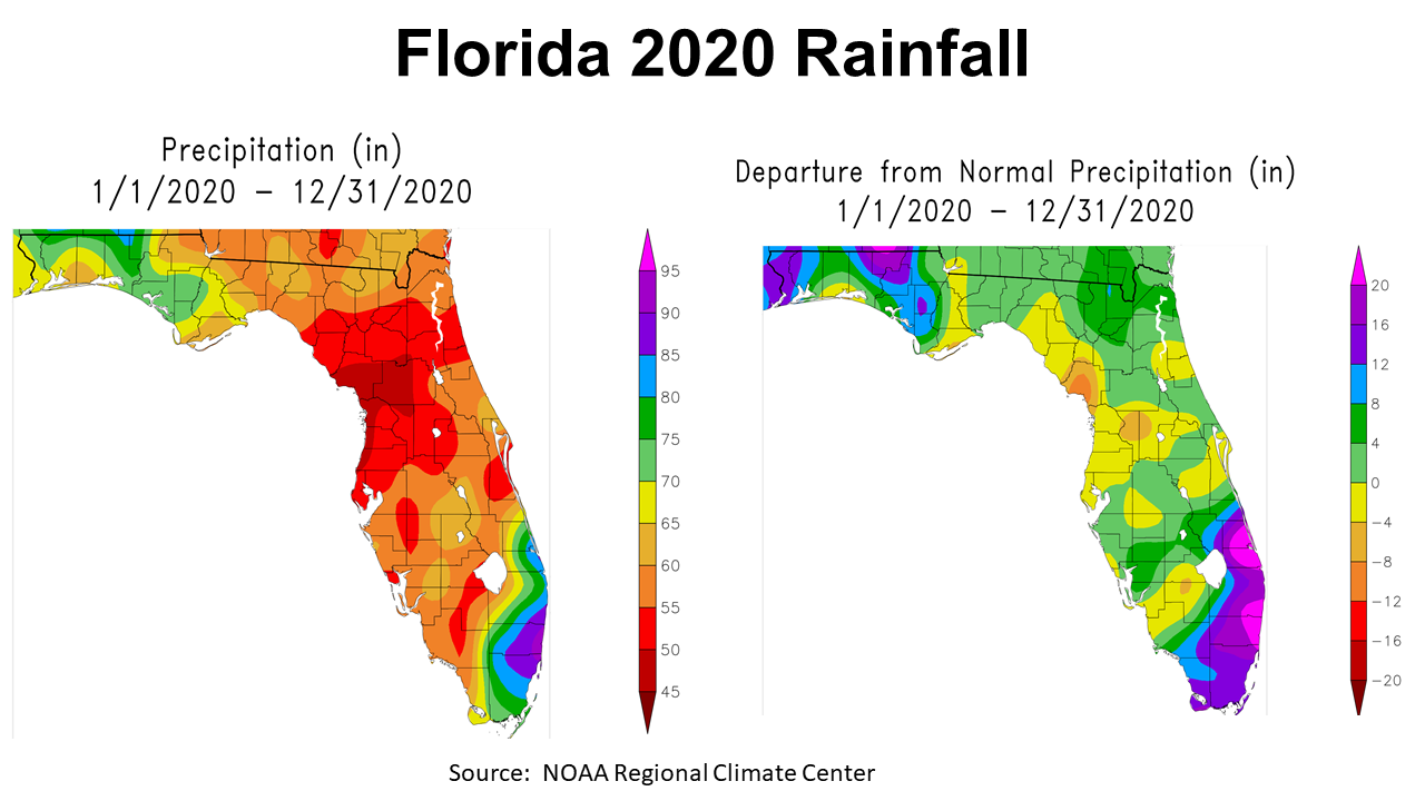
2020 was a year most people are happy to move on from for many reasons, but for much of the Panhandle weather was a major negative factor. The primary concern was heavy rainfall late in the growing season from Hurricanes and Tropical Storms, on top of an above average rainfall summer. The map to the left shows estimated total rainfall zones. You can see there were large areas of the Panhandle in green and blue that received more than 70″ in 2020. The map to the right shows how these totals compare to historic average. The shaded sections in purple and magenta received more than 12″ above average for the year. Only the areas shaded in yellow and tan were below average.
–
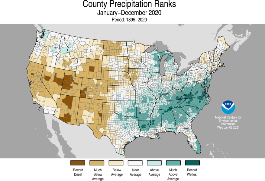
NOAA also provides ranking comparisons to average annual rainfall by county. Their map shows that the counties west of the Apalachicola River were above average, and Jackson and Holmes County were much above average for 2020.
–
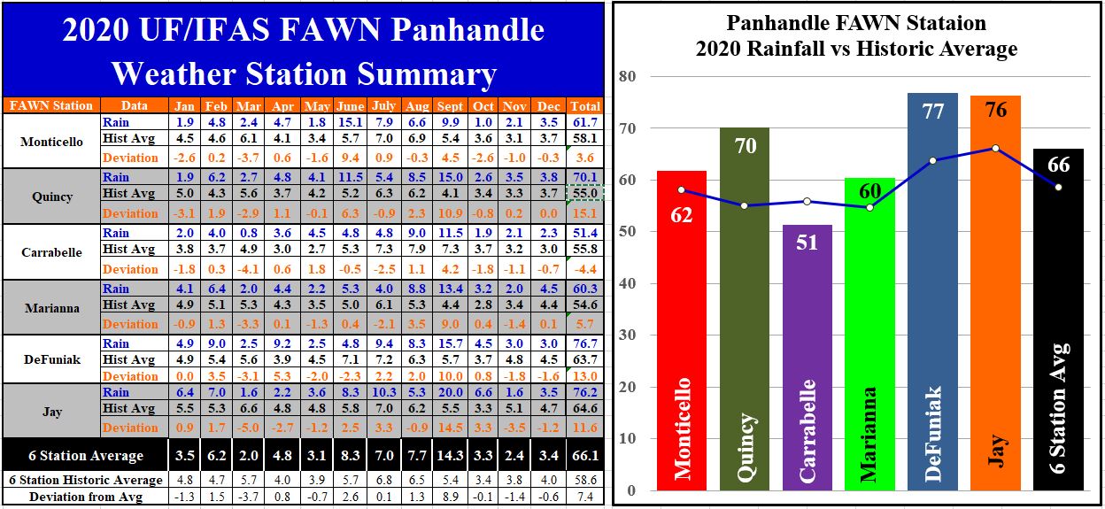
The six Florida Automated Weather Network (FAWN) stations located across the Panhandle showed the variation in rainfall in December and for the entire year in 2020. The highest rainfall total in December was 4.5″ at Marianna, 0.1″ above average, but was the only station of the six that was above average. The driest location was Carrabelle with only 2.3″, which was -0.7″ below normal. The average for all six stations was 4″, which was -0.6″ below average.
Through all 12 months of 2020, the direst location was Carrablle with only 51.4″, -4.4″ below historic average. The station in DeFuniak recorded a whopping 77″, which was 13″ above average. The Jay Station recorded 76″ (11.6″ above average), so you can really see the influence of the tropic systems last year. The Carrbelle station was the only location that was below average for the year. The average for all six locations was 66.1″, which was 7.4″ above the 58.6″ average.
–
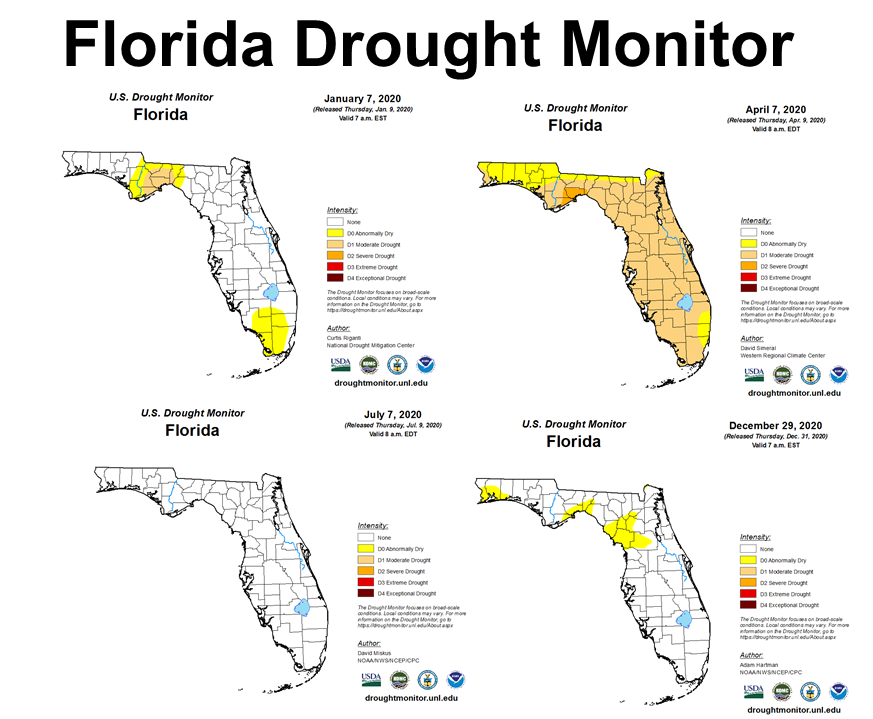 You can see in the maps above that there were areas of the state that started off 2020 in the drought monitor, and got even direr at the beginning of April. But in early July the whole state was normal or above. By year’s end, and even though 2020 was a year with above average rainfall, there were areas that got dry again.
–
 Temperatures
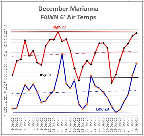
Air temperatures actually warmed up at the end of December, but over all was cooler than 2019. The high for the month was 77° on December 12, and the low 28° on December 26. The average for the month was 51°, which was 5° cooler than the 56° average in December 2019.
–
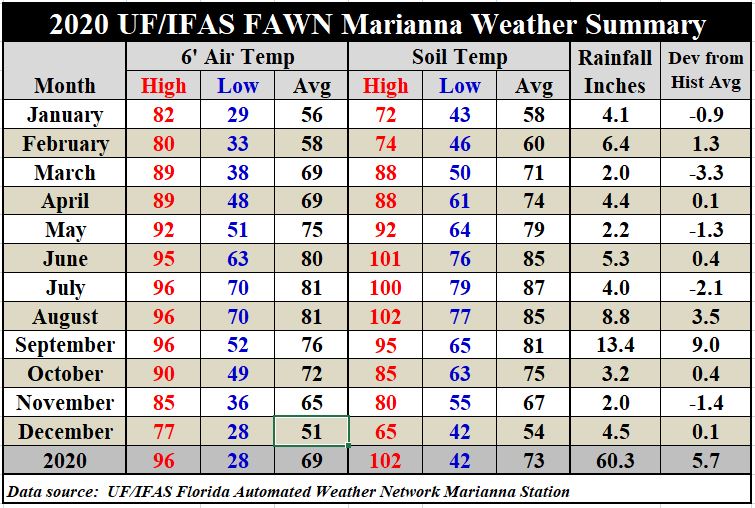
Temperatures cooled down significantly in December 2020, dropping from an average air temperature of 65° in November by 14° to an average of 51° in December. Soil temperatures dropped 13° from an average of 67° in November to 54° in December. It was the first cold Christmas we have enjoyed for some time. For the entire year, the simple average was 69°,
-\
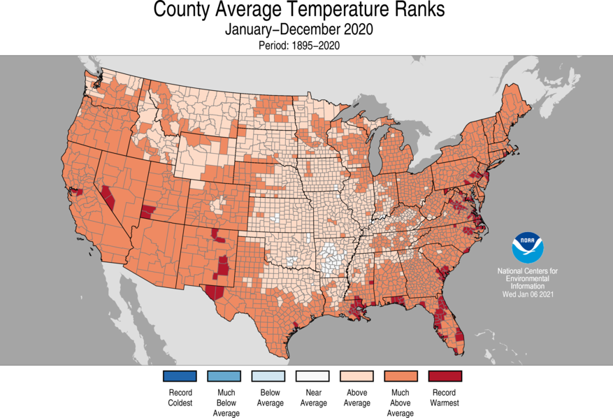 NOAA has weather data dating back to 1895 and tracks variation in climate as it changes by month and by year. In the map above you can see that all of the Southeast was much warmer than average in 2020 (orange), but Okaloosa, Walton, Holmes, Washington, and Bay Counties (red) set records for the warmest year in 125 years.
–
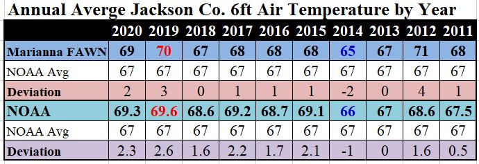 According to NOAA, the annual average air temperature from 1901-2000 in Jackson County was 67°. I have tracked temperatures at the Marianna FAWN station since 2011. In the chart above I compared the simple annual average temperature at that location to NOAA’s reported average. When you compare 2020 to 2019, the difference at the FAWN station was only 1° cooler, and based on NOAA’s data, it was only 0.3° cooler than 2019, which set the record for the highest annual average in the county. The general trend over the last decade was that Jackson County is getting slightly warmer with some variation from year to year.
Download the complete set of weather records from the Marianna FAWN station, and rainfall records from all six stations in the Panhandle by using the following link:
2020 Jackson Co Weather Summary
–
First Quarter 2021 Outlook
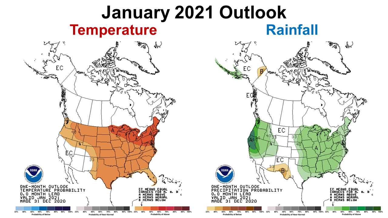
The Climate Prediction Center (CPC) provides a one month outlook that is updated at the end of the previous month. They are expecting January rainfall to be above average, which is a change from what had been predicted, based on the La Niña influence. However, there are other factors that influence local weather, especially in the winter months than simply the ENSO phase.
–
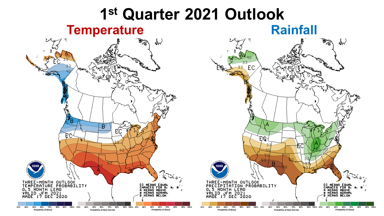
The most recent CPC three-month outlook still calls for warm dry weather, based primarily on La Niña. It will be interesting to see if this outlook changes later this month, but the best information we have at this time is that February and March will be drier than normal, particularly in the Big Bend and across Peninsular Florida.
–
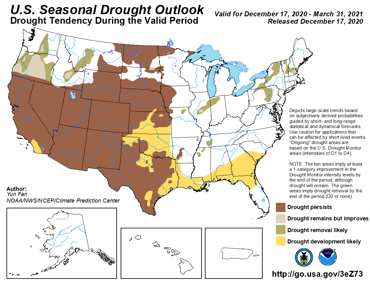
Based on the previous outlook, the CPC is expecting a large area of the Gulf Coastal Plains to be back in the drought monitor by the end of March. However, this too will be updated in at the end of next week, so we can hope for a more positive outlook.
–
La Niña Advisory
The CPC has adjusted their La Niña slightly since our last weather discussion. There is a good chance, 50% of going back to Neutral in late spring. However, this will be updated again next week as well.
La Niña conditions are present. Equatorial sea surface temperatures are below average from the west-central to eastern Pacific Ocean. The tropical atmospheric circulation is consistent with La Niña. La Niña is likely to continue through the Northern Hemisphere winter 2020-21 (~95% chance during January-March), with a potential transition during the spring 2021 (~50% chance of Neutral during April-June). Climate Prediction Center
–
What does this mean for farmers and ranchers?
2020 was a year of extremes for sure. From drought to flooding, and then back to dry again. It was the warmest year on record for five counties, and well above average all across the Southeast. Early indications are that 2021 is going to start warmer than normal dry. Hopefully we will all get vaccinated for COVID19 and it will start raining again before planting season begins for peanuts and cotton. It does appear that corn, pasture, melon and vegetable planting will start in a dry period. I know everyone is positive about the calendar changing from 2020 to 2021. Maybe this will be the year that we get perfect weather for crop and forage production, but those have been rare over the last decade. Every year is a new challenge in agriculture. All indications are that markets should improve as we move through 2021, let’s all hope the weather does too, and we don’t have major storms that ruin promising crops again.

demayo@ufl.edu - 850-482-9620
Follow me on Twitter
@UFCowman
- June 2025 Weather Summary and Three-Month Outlook - July 11, 2025
- Friday Feature:Pipeline Farming Accident - July 11, 2025
- May 2025 Weather Summary and Summer Outlook - June 20, 2025