Compared to December, January was pretty mild up until Sunday January 22, 2017, which was a scary, and really stormy day with high winds, tornado warnings and heavy rains as a cold front rumbled across the Panhandle. The unusually warm temperatures fueled a storm system that was more typical of late March or April than January.
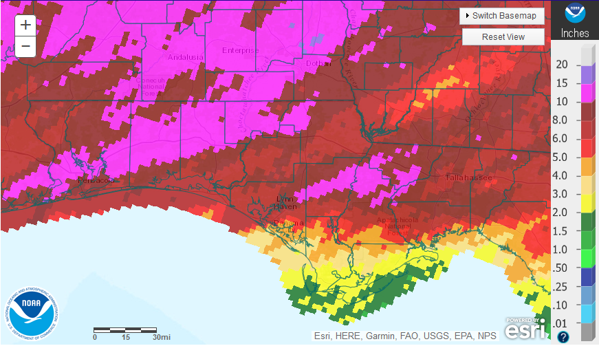
The graphic above, provided by the National Weather Service, shows where those strong cells passed through the Panhandle in January. The hot pink regions had more than 10″ of rain the dark red 8-10″, light red 6-8″, and the tan, yellow and green where less than 4″ fell last month. You can really see where the heavy bands of rain passed through on that stormy weekend.
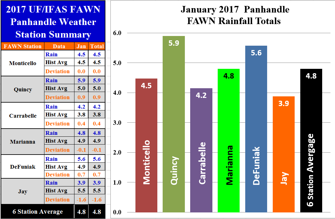
 The University of Florida’s Florida Automated Weather Network (FAWN) stations also showed some variation in rainfall for January 2017. The Quincy station recorded 5.9″, which was the highest total in January, while only 3.9″ fell at Jay. For the month, only the Jay and Marianna stations recorded less rainfall than the historic average for those locations.
 Temperatures were fairly mild across the Panhandle in January. There were 13 days with high temperatures above 60° recorded at the Marianna station.There were only seven days with lows below the freezing mark, and a low for the month of 27° in Marianna. The average air temperature was 48° and the average soil temperature was 52°.
Spring Outlook
Ground Hog Forecasts
Punxsutawney Phil, the famous ground hog from Punxsutawney, Pennsylvania, saw his shadow on Thursday, so according to him we can expect six more weeks of winter. However, General Beauregard Lee, the famous groundhog from Lilburn, Georgia, did not see his shadow. He also predicted that the Atlanta Falcons will win the Super Bowl, so we will find out very soon how accurate this ground hog is. Based on this silly annual ritual, I guess just the northern US will have an extended winter, but spring will come early for the south. I am sure these prognosticating rodents are accurate at least 50% of the time.
Climate Prediction Center Outlook
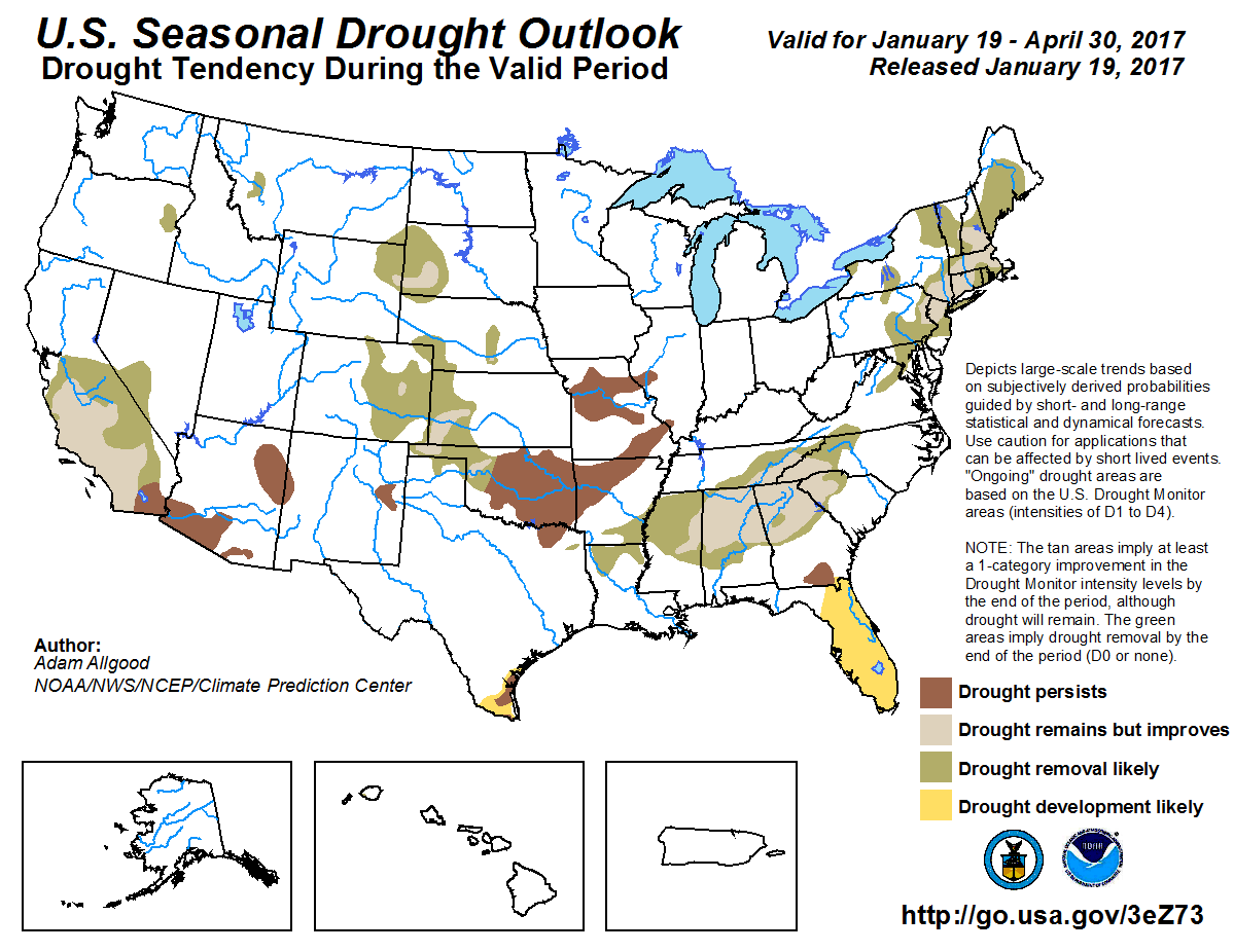
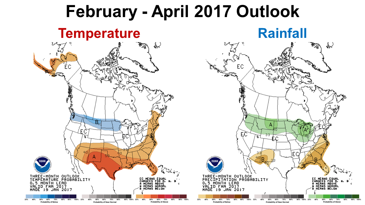
The Climate Prediction Center (CPC) provides two types of digital longer-term weather forecast tools: the Seasonal Drought Outlook, and the Temperature and Rainfall Outlook.
 The CPC is expecting drought conditions to improve across much of the Southeast over the next three months. This is good news for our neighboring states, who suffered through extended drought through much of the growing season last year.
 The CPC is, however, forecasting above average temperatures and below average rainfall In February, March and April. So they expect enough rain to improve the drought situation, but still below normal. After the past few years, it is getting harder to remember what normal weather was like.
Neutral is Coming as La Niña Fades
The latest report from the CPC on La Niña says that they expect transition to the neutral enso-phase in February.
La Niña Advisory: La Niña conditions are present. Equatorial sea surface temperatures (SSTs) are near-to-below average in the central and east-central Pacific Ocean. They are above-average in the far eastern Pacific Ocean. A transition to ENSO-neutral is expected to occur by February 2017, with ENSO-neutral then continuing through the first half of 2017.
- 2025 Weather Summary and 2026 1st Quarter Outlook - January 16, 2026
- 2025 Average Farmland Rental Rates, Lease Agreements, and Worker Wages Summary - January 16, 2026
- Friday Feature:1954 How to Dial Your Phone - January 16, 2026

