 Rainfall
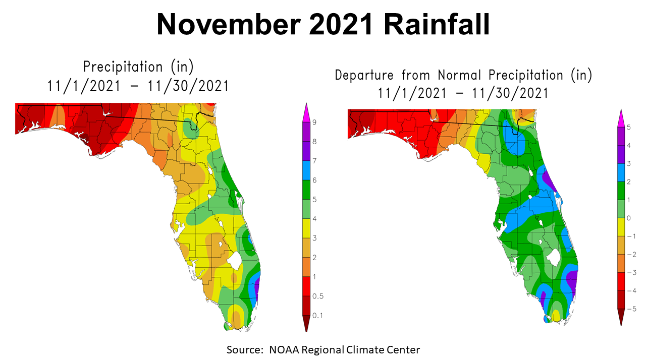
November was not a typical month across the Panhandle. After months of above average rainfall in 2021, La Niña kicked in with a vengeance. The map above to the left shows the actual estimated rainfall for November. The entire Panhandle received less than 2″(gold), while much of the region received less than an inch (red and dark red). The map to the right shows departure from normal rainfall for November. Escambia and Santa Rosa Counties were 4″ below normal, while Jefferson was only an inch below normal for the month.
–
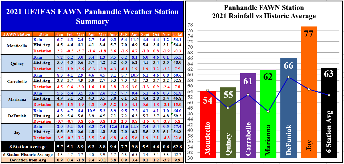
The data from the six Florida Automated Weather Network (FAWN) stations shows more specifically the variation in rainfall in November. The weather station in Quincy only recorded 0.1″, which was -3.2″ below historic average. The station in Monticello recorded 1.2″, but was still almost 2″ below normal. The average for all six stations was 0.6″, which was -3.2″ below average.
With one month still to go in 2021, the wettest location has clearly been Jay with a total of 77.4″, which is 22.6″ above average. The driest location has been Monticello with 54.1″ through 11 months, which was just 0.3″ below normal to this point.
–
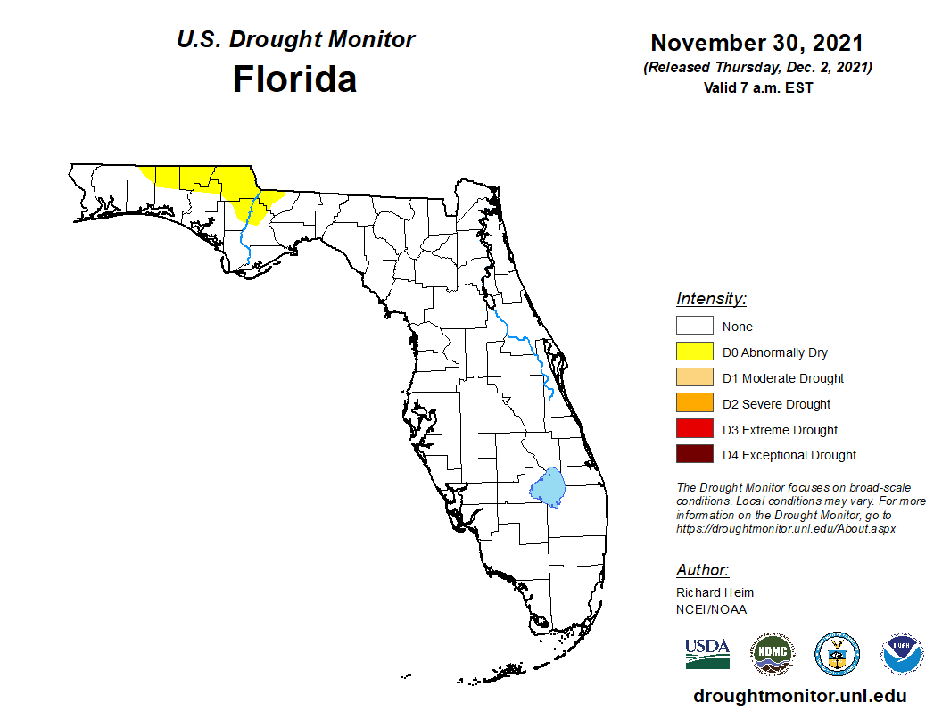 After such a wet growing season, it is hard to believe how quickly soils dried out over the last month. At the end of November, seven Panhandle Counties were added to the D0 or Abnormally Dry category of the US Drought monitor. This week the number has grown to 12 counties in North Florida.
–
Temperatures
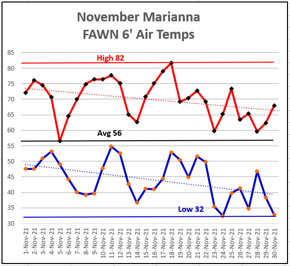
The interesting change in climate started over the last month as dry cold fronts swept through the region. The average air temperature in Marianna for November was only 56°. The high for the month was 82°, which occurred on November 18, while the low of the month was 32° on November 24.
–
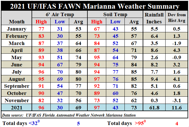
As mentioned earlier, the average 6′ air temperature was 56° in November, a 14° drop from 70° the previous month. The average soil temperature also dropped 14° to 62° in November. This drops the overall annual average down to 69° thus far. Download the full report of daily rainfall and temperatures by using the following link: Jan-Nov 2021 Jackson Co Weather Summary
–
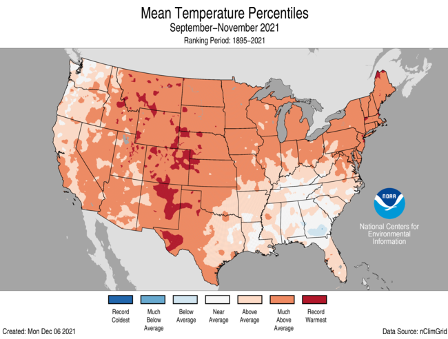
While much of the country was much warmer than normal this fall, the Panhandle has had mor3e normal temperatures. Portions of South Georgia were actually below average from September through November.
–
Climate Outlook
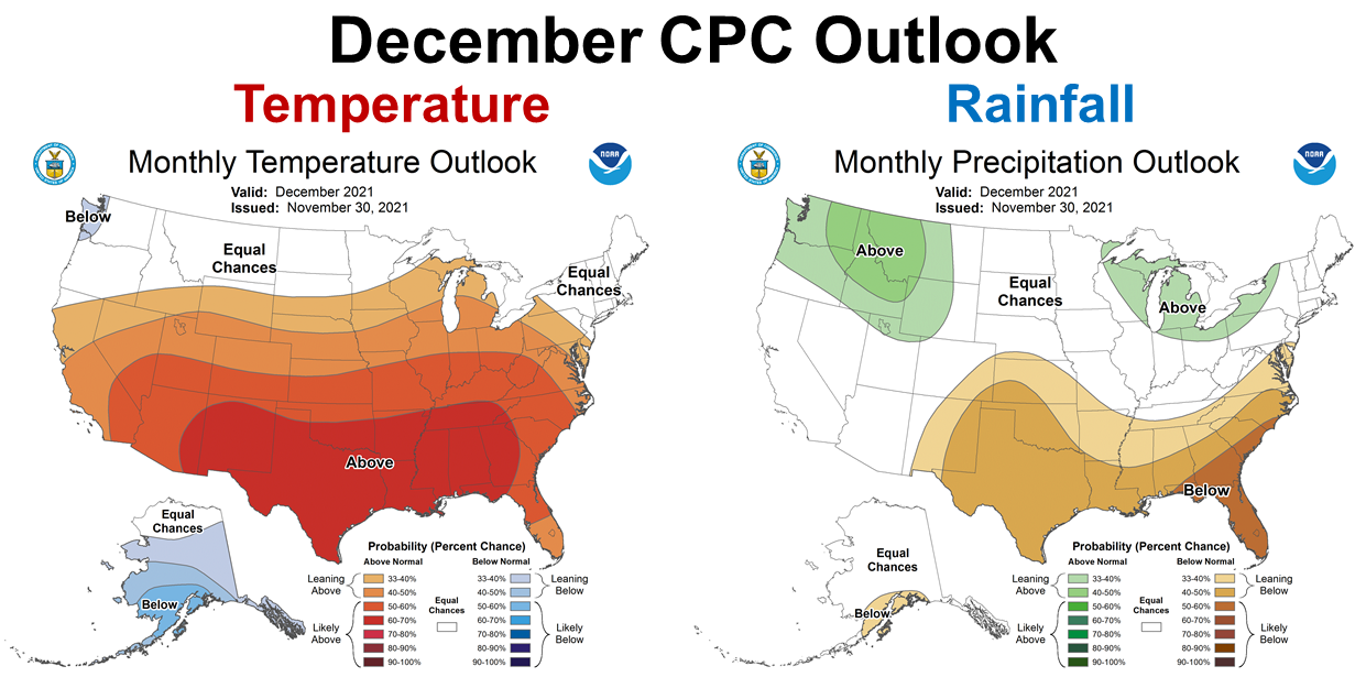
The La Niña affect is expected to continue in December. The Climate Prediction Center (CPC) is expecting well above average temperatures across the Panhandle in December. They are also expecting the short-term drought to continue as well.
–
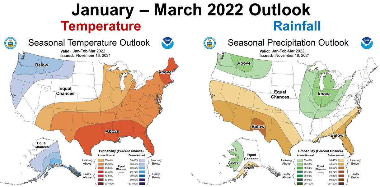
Through the first quarter of 2022, the CPC is also expecting this trend of warm and dry conditions to continue. ENSO Neutral should return in late spring, but could hold off until early summer.
–
La Niña Advisory
We are currently experiencing the ENSO La Niña phase. This climate change is caused by cooler Pacific Ocean temperatures that affect how fronts are formed and move across the US from west to east.
La Niña is present. Equatorial sea surface temperatures are below average across the central and east–central Pacific Ocean.The tropical Pacific atmosphere is consistent with La Niña conditions. La Niña is likely to continue through the Northern Hemisphere winter 2021–22 (~90% chance) and into spring 2022 (~50% chance during March–May). Climate Predication Center
–
What does this mean for farmers and ranchers in the Panhandle?
As I feared when they first started predicting a second round of La Niña this winter, the affects are clear. Even though we had well above average rainfall through much of 2021, it has come to screeching halt. November was pretty dry, and the best information we have available is that this trend will continue through at least March, and perhaps longer. This will not be a great year for dryland small grains and winter grazing. Irrigated fields, however, may have a real advantage as farmers can control when and how much moisture is present without as many issues with fungal diseases, as in wetter winters. La Niña could affect planting season next spring for corn, melons, and even early cotton and peanuts. 2022 may be a season with a slow start in dryland fields, but it is still way too early to tell. Remember last winter when the Polar Vortex boosted our moisture levels, so these climate outlooks define long-term trends not weekly forecasts. This forecast is yet another reminder of that famous saying in the Panhandle, “You may have farmed all of your life, but you have never farmed this year!” We will see how this develops, and hope the Pacific Ocean temperatures rise again to allow more frontal moisture for the southern states. If not, all of the center pivots that were on vacation much of 2021 may be working overtime come planting time in 2022.
- 2025 Weather Summary and 2026 1st Quarter Outlook - January 16, 2026
- 2025 Average Farmland Rental Rates, Lease Agreements, and Worker Wages Summary - January 16, 2026
- Friday Feature:1954 How to Dial Your Phone - January 16, 2026

