
Rainfall
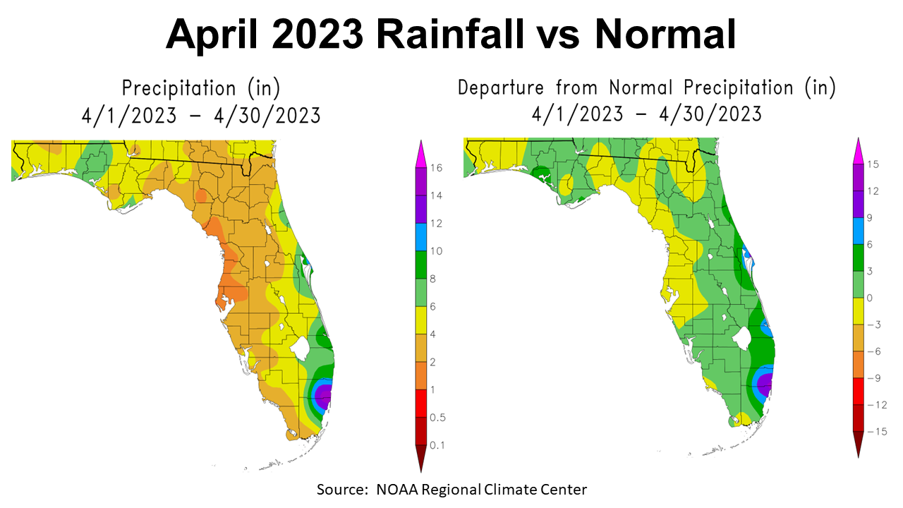
While April rains brought drought relief to the Central Panhandle, they were not at all uniform across North Florida. The map to the left above shows the estimated rainfall throughout the state in April. There were a few areas in the Panhandle with only 2-4″ (tan), but the majority of the region received 4-6″ (yellow), with parts of Bay, Washington, Holmes, Walton, and Jackson Counties receiving 6-8″ (green). The map to the right shows how April rainfall compared with historic average. Much of Bay County was 3-5″ above normal (dark green), with most of the Central Panhandle 0-3″ above average (green). However, all of the areas in yellow were slightly below average (0-3″) for the month.
–
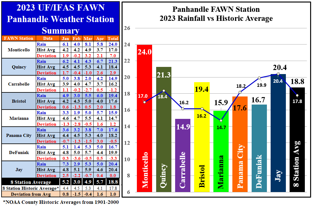
There are now eight Florida Automated Weather Network (FAWN) stations in the Panhandle, with the addition last summer of stations in both Bristol (Liberty County) and Panama City (Bay County). In April the station in Panama City recorded 7″, which was 3″ above historic average for Bay County. Compare that with only 4.2″ in Carrabelle, just 63 miles east, as the crow flies. Even so, Carrabelle was 0.5″ above normal for Franklin County. The average for all eight stations was 5.7″, which was 1.6″ above normal.
With the addition of April rainfall, only the stations in Carrabelle (14.9″) and DeFuniak (16.7″) were below average through the first third of 2023. The wettest location thus far in 2023 was in Monticello, where 24″ has been recorded, a full 7″ above normal for that location. The average for all eight FAWN stations in the Panhandle was 18.8″, which was 1′ above normal.
–
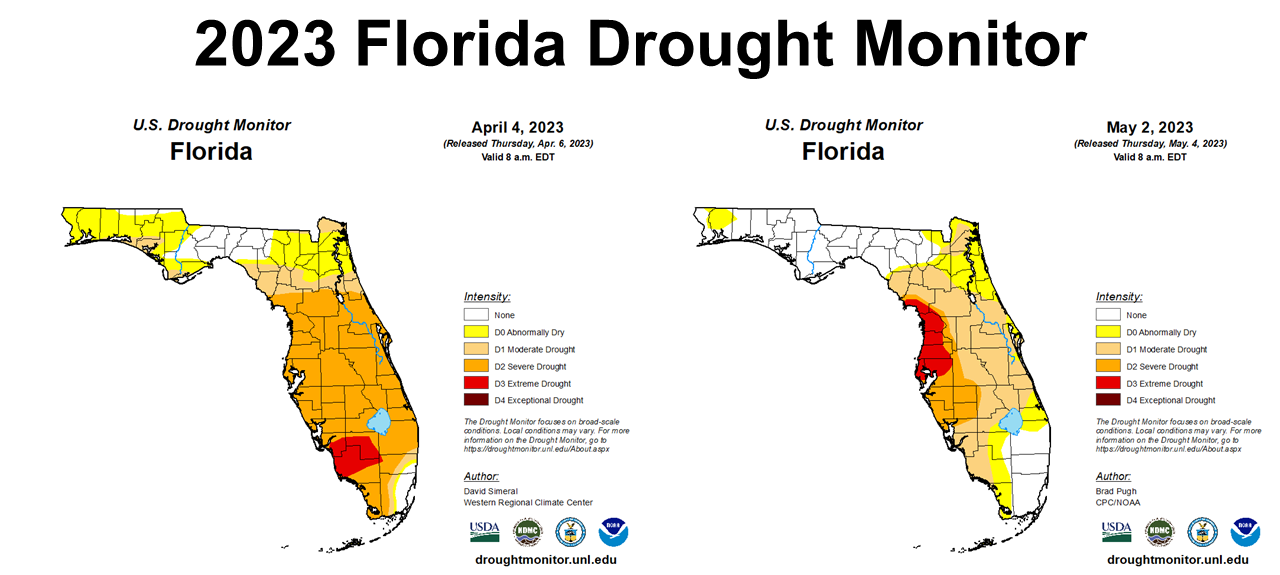
As you would expect, the Florida Drought Monitor also shows improvement across North Florida from the beginning of April through the beginning of May. In the Panhandle, only Santa Rosa County remained in the Abnormally Dry category. This was not the case for the Gulf Coast of the Florida Peninsula. That area was moved into the Extreme Drought category and has since expanded in May.
–
 Temperature
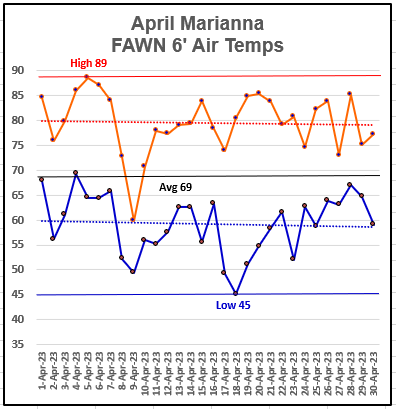
There were some dramatic temperature swings in April ranging 44°, from a high of 89° on the afternoon of April 5th, to a low of 45° on April 18th. All in all, April had some pretty mild temperatures with lows in the 50s and highs in the 80s. The average air temperatures was 69°.
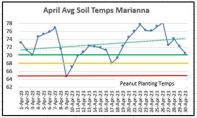
The average soil temperature gradually rose through the month, but remained above 70° from April 19th on. 70° and above is ideal for peanut seed germination, so barring two cool snaps, the soil was warm enough for planting later in the month.
–
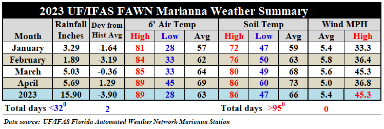 Overall, The average air temperature rose 5°, from 64° in March to 69° in April. Likewise the average soil temperature rose 5°, from 68° in March to 73° in March. There were some nasty spring thunderstorms that rolled through in April across the Panhandle, but the high wind speed at the Marianna station was just under 37 mph, while the station in Jay recorded a high wind gust of 51 mph for the month.
–
Summer Climate Outlook
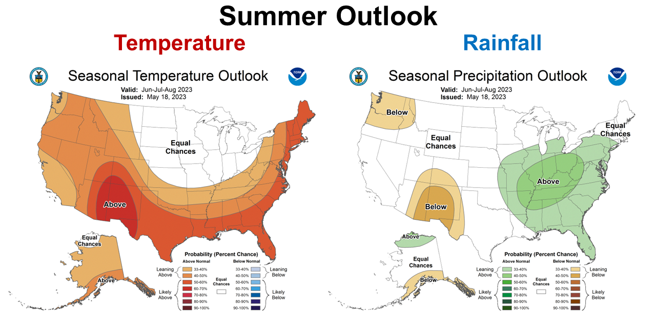
The Climate Predication Center (CPC) updated their Summer Climate Outlook this week. They are expected a warm and wet growing season this year. Certainly this forecast comes from the expectation of a coming El Niño. The CPC expects the largest impact the next three months to be in the Tennessee Valley, but all of Florida is expected to be wetter than normal.
–
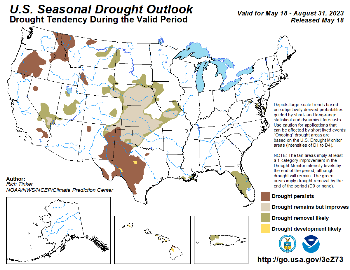 Good news for Florida, the CPC also expects the current drought in the Peninsula to end soon. Only parts of Texas and New Mexico and the Pacific Northwest are expected to remain in persistent drought by the end of this summer.–
–
El Niño Watch
The CPC is still forecasting a transition to El Niño this summer and through the winter. There is speculation this may be a moderate to strong El Niño. This transition is expected sooner than this fall.
ENSO–neutral conditions were observed May 15. Equatorial sea surface temperatures (SSTs) are near–to–above average across most of the Pacific Ocean. A transition from ENSO–neutral is expected in the next couple of months, with a greater than 90% chance of El Niño persisting into the Northern Hemisphere winter. NOAA Climate predication Center/NCEP
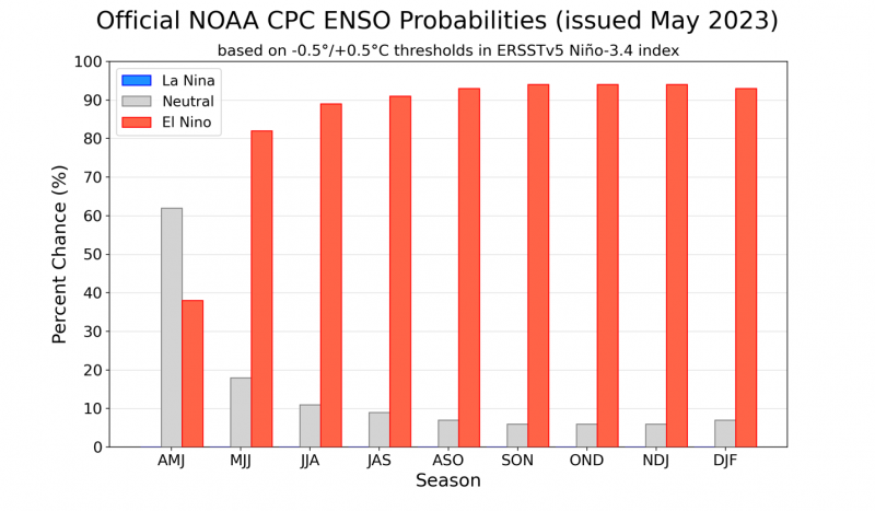
Official ENSO probabilities for the Niño 3.4 sea surface temperature index (5°N-5°S, 120°W-170°W). Figure updated 11 May 2023.
–
So what does this mean for Panhandle Farmers and Ranchers?
Goodbye drought and La Niña, but here comes El Niño. It looks like a wetter and warmer than normal growing season for 2023. Pam Knox addressed the most recent CPC Outlook graphics in in her, Climate and Agriculture in the Southeast blog site this week.
The latest climate outlook for the US was released May 18 by NOAA. The outlook showed that the outlook for June only showed slight leanings in temperature and precipitation in the area around Florida, but the 3-month outlook for June through August shows that for the entire Southeast, temperatures are expected to be warmer than normal, especially in the area around Florida, and nearly all of the region is expected to be wetter than normal. This is good news for farmers because it means that a prolonged drought is unlikely, although dry spells may occur and some limited drought is certainly possible. It also means that humidity levels are likely to be high and that will lead to more fungal diseases due to the generally moist conditions.
With lots of available moisture, there is a higher likelihood of scattered showers occurring frequently through the summer, which could cause some problems for hay producers and others who might need several days of dry weather to get field work done. Farmers will want to be watching the weather forecasts for windows of opportunity between rain spells if hay cutting or chemical applications need dry conditions. Due to the expected wet conditions, the drought in Florida is predicted to go away over the next couple of months.
The seasonal outlook for winter show the typical pattern for a strong El Nino, with wetter conditions than normal covering a lot of the southern half of our region. Warmer than normal conditions are predicted for the winter in spite of El Nino’s tendency to bring cooler temperatures. Not surprising, since winter is the season with the fastest warming due to climate change, so the prediction is likely showing the high likelihood of the trend continuing. Pam Knox, Director of the UGA Weather Network and Agricultural Climatologist – Warmer and wetter conditions expected this summer
Drought is never good for crop production, but neither is being too wet for field work or harvests. Dryland farmers and ranchers should benefit from more consistent rain this summer. The question is how much more rain than normal? That still remains a key question. Timeliness of pesticide applications and hay harvest could be more challenging this year. Drought years are generally lowest for crop and forage yields, but really wet years are significantly lower than normal as well due to weeds, diseases and prolonged harvest past maturity. Stay tuned as we watch this develop over the summer.

demayo@ufl.edu - 850-482-9620
Follow me on Twitter
@UFCowman
- May 2025 Weather Summary and Summer Outlook - June 20, 2025
- Friday Feature:The History of Angus Cattle - June 20, 2025
- Friday Feature:High Quality Legume Hay Production – Virtual Tour of Conrad Farms - June 6, 2025