
Rainfall
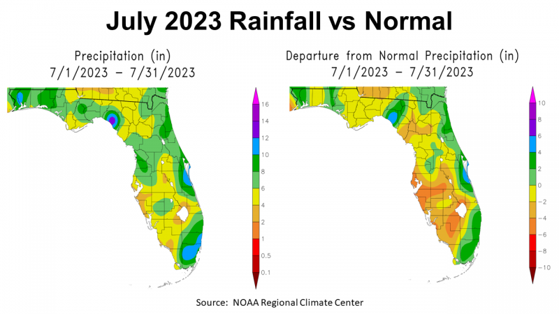
July was a hot month with near average rainfall for much of the Panhandle. In the map above to the left, you see the estimated rainfall throughout the state of Florida. Most of the Panhandle was in the 4-6″ range (gold) or the 6-8″ range (light green). There were pockets with higher rainfall totals however, 8-10″ (green), 10-12″ blue, or even 12-14″ (purple). July is typically one of the wettest months of the year in Florida but this year rainfall was not uniform across the state.
–
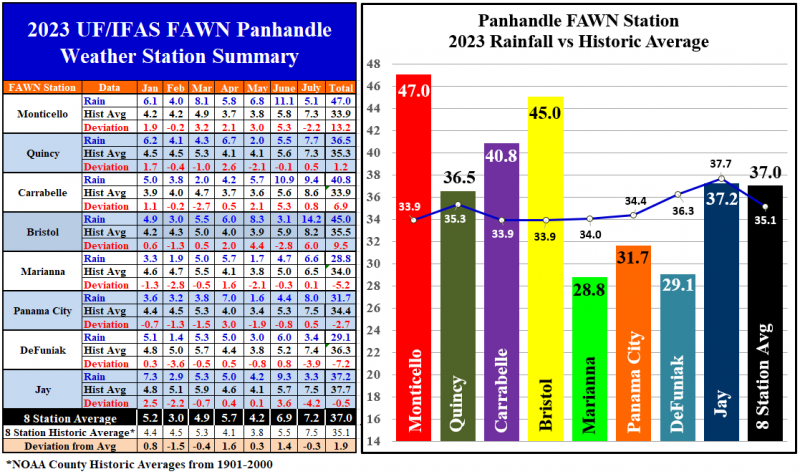
The eight Florida Automated Weather Network stations show more precisely the variation in rainfall across the Panhandle. Bristol was by far the wettest location with 14.2″, which was 6″ higher than normal for July. Compare that with the station at Jay that only received 3.3″, which was -4.2″ below average for the month. The average for all eight FAWN stations was 7.2″, just -0.3″ below normal.
The Panhandle is split so far in 2023, with the four eastern locations above average and the four western locations below normal. Through the first seven months of 2023, the average for all eight FAWN Stations was 37″, which was 1.9″ above average. Despite a drier than normal July, the Monticello station still has the highest total for the year thus far with 47″, which is still 13.2″ above average for the first seven months. The Marianna station had the lowest total of 28.8″, which was -5.2″ below normal.
–
Temperatures
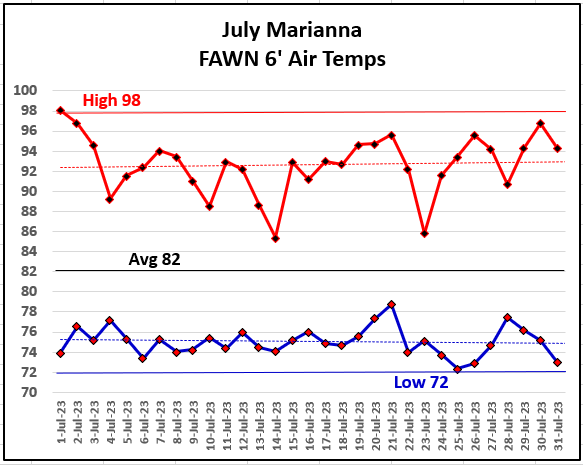
July overall was a hot month, but not with the extreme temperatures seen in the Southwestern U.S. The high temperature for the months was 98° on July 1st. The low for the month was 72° on July 25th. Early morning temperatures last month provided little relief for man or beast. The average air temperature for July 2023 was 82°. For comparison sake, the Marianna FAWN Station average air temperature in July 2022 was 81°, 80° in 2021, and 81° in 2020.
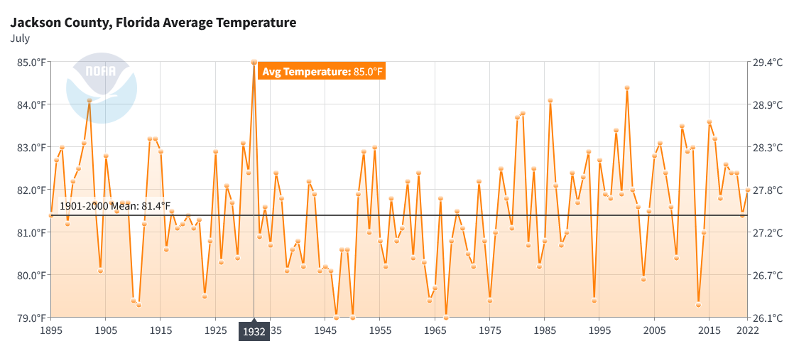
NOAA’s Climate at a Glance provides county average temperatures since 1895. The chart above provides historic temperature records for Jackson County and shows that the hottest average July temperature on record was 85° in 1932, the same time period as the Dust Bowl in Oklahoma and surrounding states. I am sure you have heard reports on the news about record global temperatures in July, but for Jackson County at least, July 2023 at 82° was not the hottest on record. This chart does show a gradual rise in July temperatures since 2014. It is interesting to look back at the historic records through the years, so you can see a general increase over time but there is significant variation year to year as well,
–
End of Growing Season Outlook
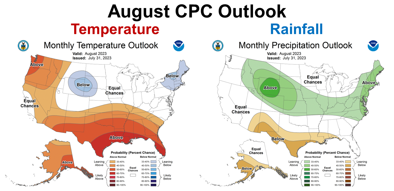
The Climate Prediction Center (CPC) provides climate outlooks for the coming months. The recently updated August Outlook shows that Florida can expect the heat to continue with warmer than average temperatures. The CPC is expecting the high-pressure heat dome to continue affecting the rainfall received in the Western Panhandle. The rest of Florida is expected to be near average in August.
–
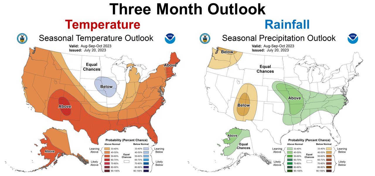
The CPC’s three-month outlook for August through October shows they expect the rest of the growing season to remain warmer than normal. They are expecting rainfall to be near average throughout Florida.
El Niño Advisory
El Niño is building in the Pacific Ocean. Right now it is still weak but is expected to get stronger through the fall and peak in the winter months.
El Niño conditions are observed. Equatorial sea surface temperatures (SSTs) are above average across the central and eastern Pacific Ocean. The tropical Pacific atmospheric anomalies are consistent with weak El Niño conditions. There is a greater than 90% chance that El Niño will continue through the Northern Hemisphere winter. Climate Prediction Center July 31, 2023
–
What does this mean for Panhandle Farmers and Ranchers?
El Niño is building in the Pacific ocean, as ocean temperatures are on the rise. The climate experts predict the greatest impact to be in the late fall and winter, so the wetter than average climate is expected to have greater impact November through February. El Niño years have fewer hurricanes, so there is hope the current trend will continue through the second half of the storm season. It does appear the the Western Counties will continue to remain hotter and drier through August. In general, it seems that farmers and ranchers can expect near average rainfall for the next three months. That means we should have a more predictable harvest season with direr conditions as we move into October. Near average would be good for crop and hay harvest in the coming months. Nothing has changed for the El Niño since my last report, but I expect more information as they watch for strengthening based on Pacific Ocean temperatures later in the year. In the Panhandle, this means November through February will be wetter than normal with stronger cold fronts passing lower across the Southern States this winter. Planting decisions for cool-season crops should be made based on the expectation of above average rainfall. Stay tuned as we monitor what the expert climate forecasters predict in the coming months. Based on what we know at this point, the weather to finish out the growing season should continue to be positive for most farms and ranches in the Panhandle.

demayo@ufl.edu - 850-482-9620
Follow me on Twitter
@UFCowman
- May 2025 Weather Summary and Summer Outlook - June 20, 2025
- Friday Feature:The History of Angus Cattle - June 20, 2025
- Friday Feature:High Quality Legume Hay Production – Virtual Tour of Conrad Farms - June 6, 2025