Rainfall
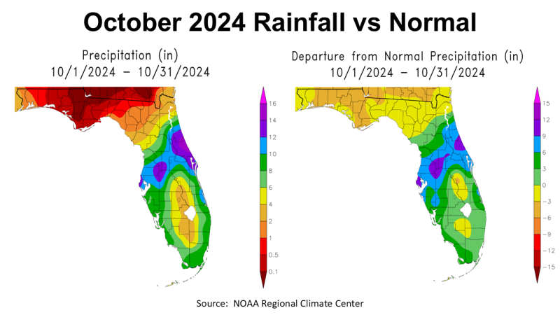
After such a wet September, October 2024 was really dry. The map on the left shows that much of the Panhandle had very limited, if any, rainfall. The areas in dark red had less than 0.1″ or none at all, the large area of crimson red had less than 0.5″, and the area in red, less than 1″ of rainfall in October 2024. There were sections of Santa Rosa County in orange that ranged from 1-2″, and the western tip of Escambia County ranged from 2-4″ in gold. The map to the right shows how October compared with historic average. All of North Florida was below average in yellow, with a large area in gold that was -3 to -6″ below average. You can also clearly see the path of Hurricane Milton across Central Florida that dumped 6-9″ in the blue shaded areas, and 9-12″ in the purple zones.
–
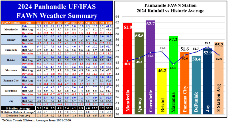
The eight Florida Automated Weather Network (FAWN) in the Panhandle showed more precise variation in October 2024. There were four FAWN stations: Quincy, Bristol, Marianna, and Panama City that had no recorded rainfall in October, ranging from -2.6″ to -3.1″ below historic average. The station in Jay had the highest recorded total of only 0.7″, which was still -2.9″ below normal. The average of all eight stations was 0.2″, which was 3″ below normal for the month.
Since January, the eight stations have averaged 55.2″, which is 4.6″ higher than average for the year thus far. The station at Carrabelle had the highest total with 62.7″ (20″ in September alone), 11.2″ above normal. That is quite a contrast with the station at Bristol that has only recorded 46.2″ through October, which was -5.6″ below historic average for Liberty County.
–
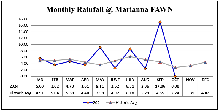
The totals and average comparisons don’t tell all of the story though. That chart above from the Marianna FAWN Station shows the crazy seesaw of rainfall in 2024, with three months (May, July, and September), with significantly higher than average rainfall and six months of drier than normal weather. After being so wet at the end of September, it is hard to imagine being so dry a month later, but the Drought Monitor below shows the results of minimal rainfall for the month.
–
The entire Panhandle is back in the Florida Drought Monitor at the end of October. The northern parts of Escambia, Santa Rosa, and Okaloosa moved into D1 Moderate Drought category at the close of the month.
–
Temperatures
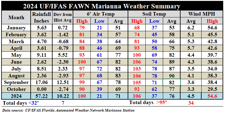
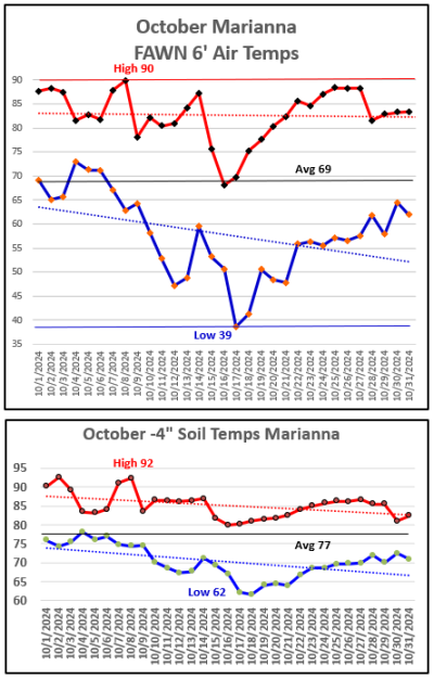 While there was very little rainfall in October, temperatures cooled off significantly in the middle of October, before warming back up above normal at month’s end. We went from a 6′ air high temperature of 90° on October 8 to a low of 39° on the morning of October 17. The average air temperature was 69°.
The soil temperature, at -4″ below the surface, ranged from a high of 92º on October 2nd and 8th, to a low of 39º on October 17th and 18th. The average soil temperature was 77º for the month.
–
The weather summary chart above shows the contrast from previous months with October 2024. The average air temperature dropped nine degrees from 78º in September to 69º in October. The average soil temperature dropped five degrees from 82º in September to 77º in October.
–
Climate Outlook
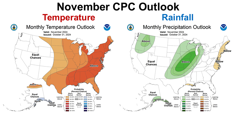
The Climate predication Center’s (CPC) November Outlook is a little more positive than what I shared with you for last month’s weathersummary. While it is still expected to be warmer than normal, the CPC made no designation for precipitation. Normal November precipitation is around three inches for most locations in the Panhandle, but after October, normal would be a big improvement.
–
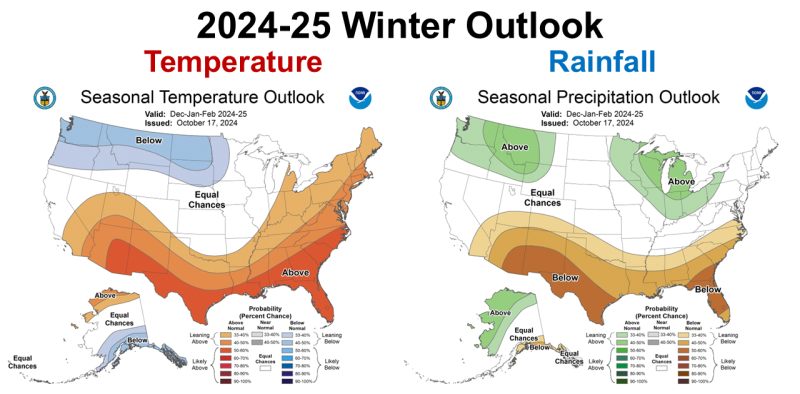
The winter CPC outlook has not changed since the last summary. The expectation is still for a warmer than normal and drier than normal winter. The CPC is still anticipating a La Niña winter, although they still have not announced the switch from ENSO Neutral. So, the La Niña Watch is still ongoing, but as of yet has not cooled enough for the transition to be official. That announcement could come out on November 14th.
–
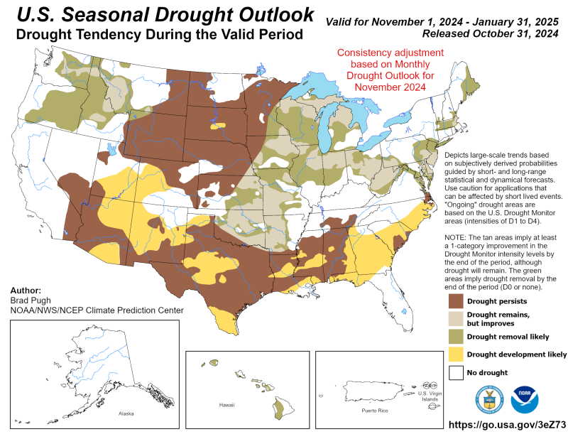
In the CPC’s Seasonal Drought Drought Outlook map above, you can see they are certainly expecting significant drought this winter throughout the Southern States. There is a whole lot of brown and yellow on that map, so that is not a great way to start the new year. Let’s all hope they are wrong.
–
What does this mean for Panhandle farmers and ranchers?
To be honest, not much has changed in the forecast since last month, but we have certainly felt the affects of a brutally dry October. While there were no interruptions in peanut, cotton, or hay harvest, pastures have stopped growing, and there is still not enough soil moisture for planting cool-season crops and forages. The window for productive cover and grazing crop planting is diminishing. If we don’t get solid frontal rainfall in the next week or two, it might not be a wise investment this year. We know from past experience that planting after Thanksgiving reduces yields, so if we truly are going to have a dry winter too, I don’t know that I would take a chance on planting without adequate moisture. One thing is for sure, if you are feeding livestock this winter you better have a good supply of hay ready. Hopefully, November will be more normal for rainfall and you will get a few inches soon to get a crop started. Just don’t expect fast growth or top yields. This does not like a promising forecast for small grain crops such as wheat and oats for grain harvest. I know we will get some rain this winter, it just won’t be abundant. If a La Niña winter does come as predicted, the experts feel it will be weak, so this may not have lasting affects for planting of crops next spring.
- 2025 Weather Summary and 2026 1st Quarter Outlook - January 16, 2026
- 2025 Average Farmland Rental Rates, Lease Agreements, and Worker Wages Summary - January 16, 2026
- Friday Feature:1954 How to Dial Your Phone - January 16, 2026

