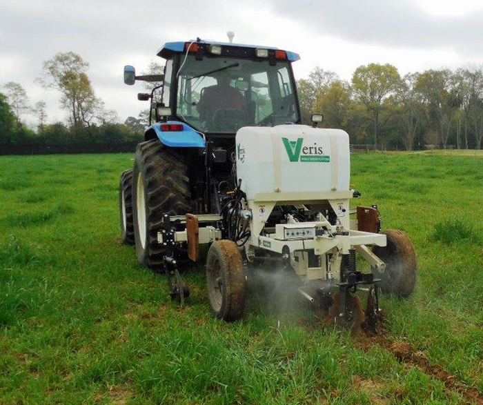
Fig. 1. Veris rig in operation with water jets engaged to clean the pH sensor Photo Credit: Cheryl Mackowiak.
The next generation of agriculture Best Management Practices (BMPs) will likely include new soil mapping technologies. Resulting maps are increasingly being used to guide variable applications of irrigation, fertilizer, herbicides, and pesticides in the field. On-the-go soil sensors have spatial dependence ranges less than the distances used by USDA soil surveys, or even most grid sampling techniques. It stands to reason that shorter sampling distances may enhance the effectiveness of variable rate technologies, thereby improving production efficiencies.
UF/IFAS, North Florida Research and Education Center (NFREC) recently acquired a Veris MSP3 (Veris Technologies Inc., Salina, KS) that uses dual wavelength (visible and near infrared) optical sensors for organic matter, pH sensors for soil pH, and pairs of coulter electrodes for direct electrical conductivity readings at two depths: 0 to 12 inches and 0 to 36 inches (Fig. 1). The onboard GPS unit provides the mapping coordinates for each sampling point (from hundreds to thousands per field), as the implement is pulled behind with a tractor across the field at speeds up to 6 mph. For this piece of equipment, the data can be post-processed and viewed online through the company site or downloaded in different formats for use with variable rate controllers.
Science comes into play with interpreting the data (mapping and calibrations), and determining how the results translate into improving farming input efficiencies. The majority of Florida surface soils are comprised of 85% or more sand, where water and nutrient leaching potential is great. Nitrogen from fertilization can quickly move into the subsoil, and often into shallow ground water. Characterizing the effect of long-term agricultural practices on soil composition, water and fertilizer leaching is therefore difficult, because the soil retention time is rapid. Among our goals is to assess the benefit of mapping technologies for these soils, and determining if on-the-go sensor technologies are viable tools for protecting water resources.

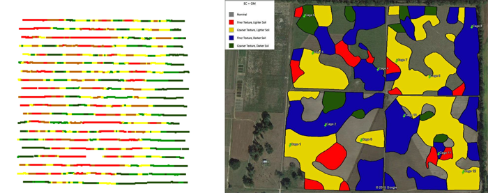
Fig 2. Example of real-time soil electrical conductivity (EC) mapping (left) and the post-process data converted into a zone map ready for variable rate applications (right), based on EC, pH and organic matter mapping. Photo credit: Cheryl Mackowiak
Researchers at the NFREC will be using soil mapping, along with soil coring, in several different Florida agricultural systems, including row cropping (conventional conservation tillage vs sod-based crop rotations), dairy silage cropping, and other forage-based agricultural systems. Currently, there are some fertilizer retailers and other groups that provide soil mapping services to producers. Mapping may seem expensive initially, but the resulting maps should save the producer money on input costs, wherever variable rate applicators are being used. Lime savings is often cited as an immediate cost savings for farmers. As these technologies mature and prices fall, even more cost savings should be realized by producers. We will provide updates on what we learn from time to time, so stay tuned!
- Grower Survey Insights on Cotton Nitrogen Management in Florida’s Panhandle - July 18, 2025
- Florida Soils are an Indispensable Natural Resource - January 10, 2025
- Regenerative Agriculture: What it Means to You - June 21, 2024
