
 –
–
Rainfall
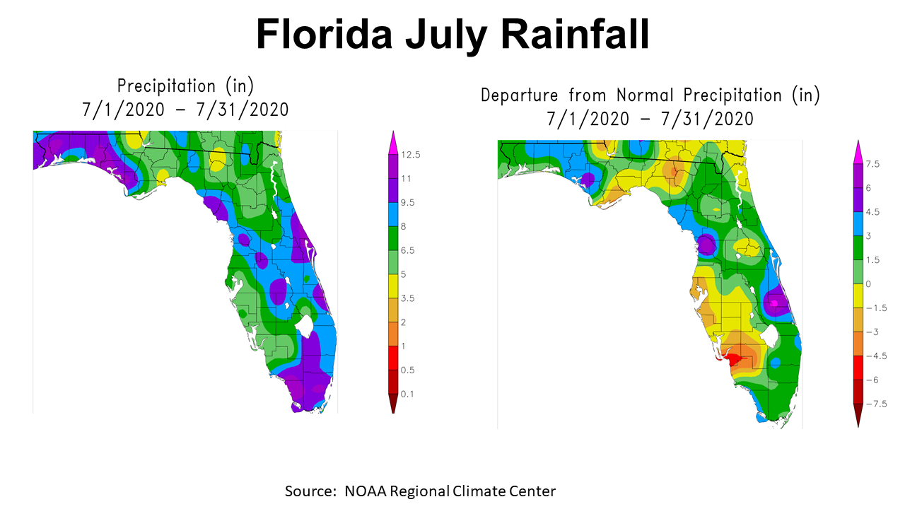
July rainfall was certainly not even across the Panhandle, but it did bring drought relief to the western counties. In the map on the left side is the estimated rainfall received in July 2020. The map on the right is the departure from normal. The entire Panhandle received more than 3.5″ in July, but the western counties had more than 8″ (blue and purple). Much of the Panhandle had above average rainfall, but the areas in yellow and tan, in the map to the right, were below average for the month.
–
 –
–
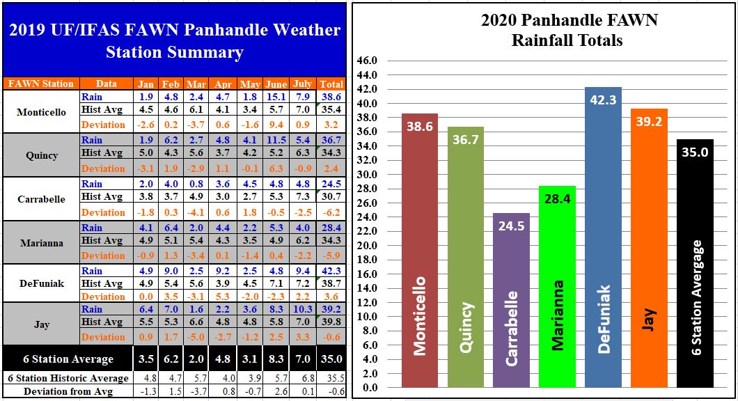
The Florida Automated Weather Network (FAWN) weather stations documented the variation in rainfall across the Panhandle. The FAWN station in Jay recorded 10.3″ in July, while only 4″ fell at Marianna. Three of the six stations were below average, ranging from -0.9-2.5″ below historic average. The average for all six stations was 7″, which was slightly above normal (6.8″). For the year, only 24.5″ of rain has been recorded at the Carrabelle station, while 42.3″ was the total rainfall in Jay. The average of all six stations from January through July was 35″, which is -0.6″ below historic average. As you can see from the bar chart above, there is large variation (18″) in rainfall totals at the six locations.
–
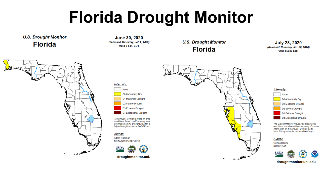 The higher rainfall totals in the western counties provided enough moisture that Escambia and western Santa Rosa Counties are no longer in the drought monitor. The west gulf coast of Peninsular Florida was added to the abnormally dry category, however.
–
 Temperatures
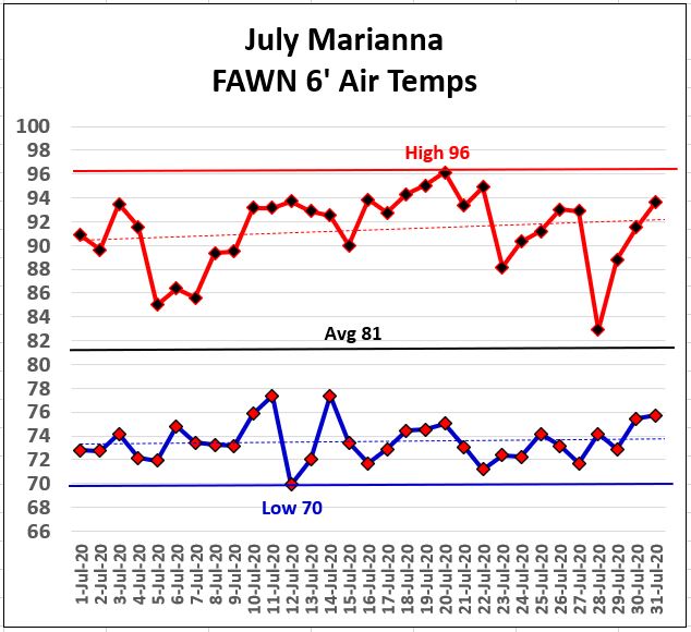
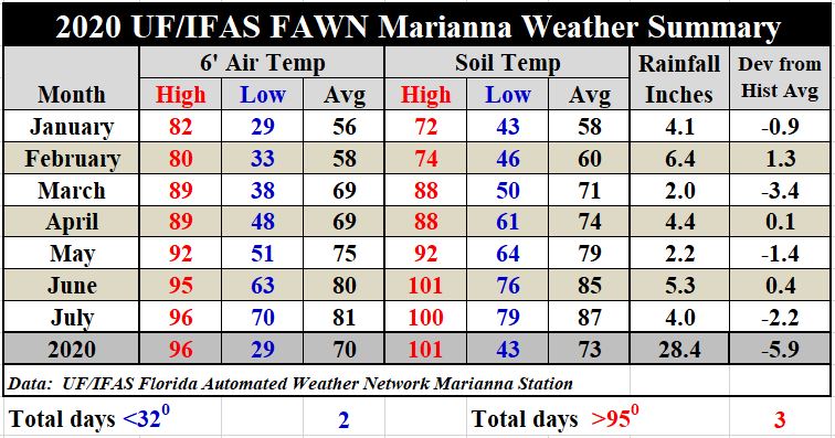
July was really hot, when it was not cloudy and raining. There were 14 of 31 days with some rainfall in Marianna, but the other days were pretty hot and sticky. 96º was the high for the month, on July 20, but there were only two days above 95° last month, so it was not extreme. The low of 70° was on July 12, so there were no nights in the 60s. The average 6′ air temperature for the month was 81º.
–
 -S
-S
As compared to June, July 2020 was slightly warmer. The average air temperature rose 1°, from 80° in June to 81°. The average soil temperature rose two degrees from 85° in June to 87° in July. But as mentioned previously, 2020 has not had extreme heat with only 3 days with air temperature highs above 95°.
To get the daily rainfall and temperatures from the Marianna station, and monthly rainfall comparisons of all six stations, use the following link: January-July 2020 FAWN Weather Summary
–
August and Fall Outlook
 –
–
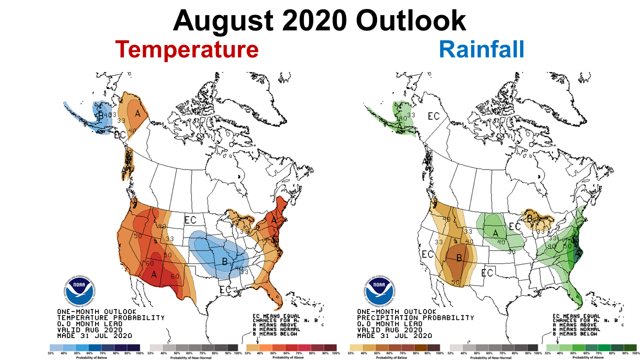
The Climate Predication Center (CPC) is expecting warmer than normal conditions in August in the Florida Panhandle, but makes no predictions for rainfall, with equal chances for below or above average.
–
 –
–
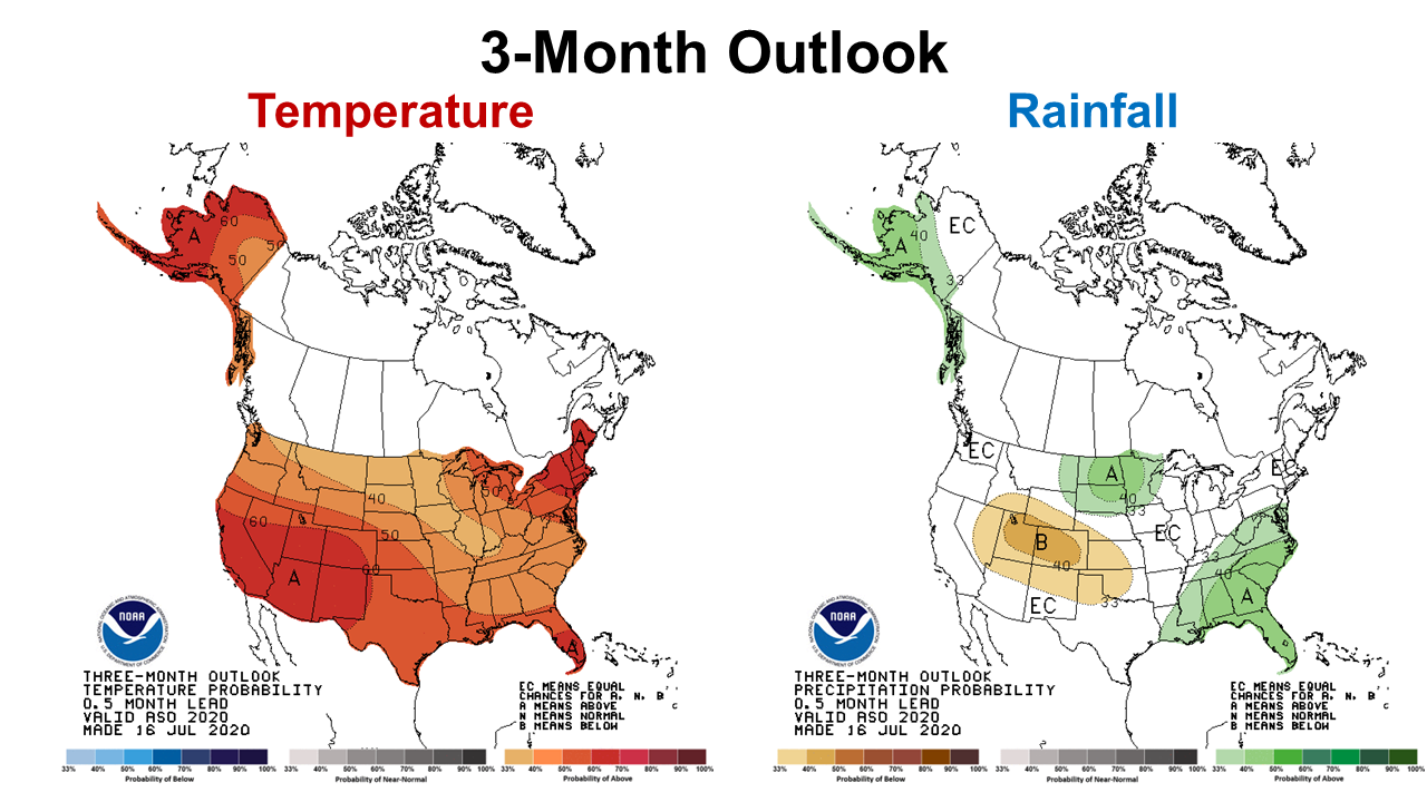
The three-month outlook for August through October is predicting hot and wet conditions for all of Florida and much of the Southeast. So, we can expect hotter than normal conditions for the remainder of the growing season, and above average rainfall to finish out the crops through harvest.
–
La Niña Watch
A La Niña fall looks more likely, but it is still too early to make a certain forecast. In general, La Niña ENSO phases are warmer and drier than normal in the Florida Panhandle.
By early August 2020, sea surface temperatures were below average in the equatorial Pacific from the Date Line to the west coast of South America. The prediction models are split between La Niña and ENSO-neutral during the fall and winter, but slightly favor La Niña from the August-October through the November-January seasons. Based largely on dynamical model guidance, the forecaster consensus favors La Niña development during the August-October season, lasting through winter 2020-21. In summary, there is a ~60% chance of La Niña development during Northern Hemisphere fall 2020 and ~55% chance of continuing through winter 2020-21. Climate Prediction Center
–
What does this mean for farmers and ranchers in the Panhandle?
Expect the hot temperatures to continue through October. The rainfall forecast in August is uncertain, but should be above average to finish up the growing season. Farmers can expect good yields where rainfall remains around average. Nothing in the CPC outlook forecasts creates great concerns, but a La Niña fall and winter is not a positive outlook for winter forage or cover crops. Hopefully there will be enough moisture to get these crops off to a good start, but may be more successful in heavier soils with higher clay content to hold onto the moisture. Sandy fields may not be the best choice for winter crop planting this year. We will need to keep an eye on this over the next month or two to get a stronger forecast, but in general, La Niña years have not been good for cool-season crop yields. The dry conditions can even affect spring planting moisture for 2021 crops. Next month’s ENSO forecast should give us a better idea of what to expect this fall and winter.

demayo@ufl.edu - 850-482-9620
Follow me on Twitter
@UFCowman
- November 2025 Weather Summary & Winter Outlook - December 5, 2025
- Friday Feature: The History of Beekeeping - December 5, 2025
- Friday Feature:Malone Pecan Festival Tractorcade - November 21, 2025