

Rainfall
September was a wild weather month in the Florida Panhandle. Hurricane Francine hit Louisiana but brought outer bands of heavy rain to the Western and Central Panhandle, and then later in the month Hurricane Helene hit the Big Bend Region with outer bands that brought heavy rains again to the Central Panhandle. The net result can be seen in the map to the left above, where portions of Gulf,& Franklin Counties got drenched with more than 21″ of rainfall (mauve and hot pink), and areas further inland blue had 15-18″ of rainfall, and in dark green 12-15″. Interestingly, the areas in North Florida that had greater wind impacts from the two storms had lower rainfall totals for the month. The map to the right shows how September 2024 rainfall compared to historic average. Only the sections in orange and yellow were below average for the month.
–
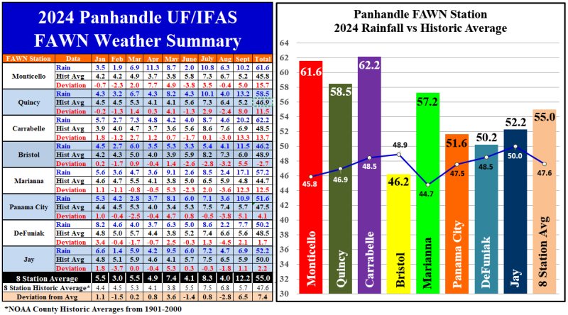
Hurricanes had a major impact on rainfall in September 2024. The eight Florida Automated Weather Network (FAWN) stations in the Panhandle show specific rainfall totals for September 2024. The Carrabelle FAWN station recorded 20.2″ in September, which was 13.3″ above average. The FAWN station at Marianna recorded 17.1″, which was 12.3″ above historic average. September 2024 set a new monthly rainfall record in Marianna, as rainfall records at this station have been kept there since 1952. That FAWN station at Jay was only affected by Hurricane Helene, but still recorded 6.9″, which was 1.1″ above normal. The average of all eight FAWN stations was 12.2″, and was 5.7″ above normal in September.
Through the first three quarters of 2024, the average of all eight FAWN stations was 55″, which was 7.4″ above average. The station at Carrabelle has had the highest total with 62.2″ thus far, 13.3″ above normal. Not far behind was Monticello with 61.6″, 15.7″ above historic average. By contrast, the station in Bristol has only received 46.2″, which was -2.7″ below normal.
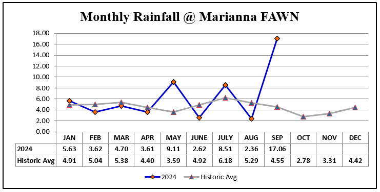 Rainfall totals only tell part of the story though, as in the example to the right you can see that at the station in Marianna was 12.5″ above average through nine months, but all of that additional rainfall fell in May, July and September. The total sounds like a wet year, but it was really wet for short periods and has been drier than normal for the six out of nine months. Not shown in this graph is that the station in Marianna has yet to record any rainfall in the month of October. So while the Central Panhandle was very wet in September, it has been dry more than wet this growing season.
–
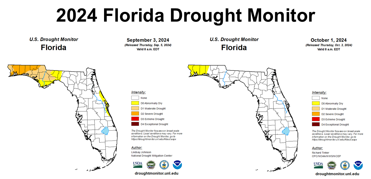
Not surprisingly, September rainfall had a positive impact on the drought situation, as show in the Florida Drought Monitor from September 3 as compared to October 1, 2024. The Western Panhandle Counties are still abnormally dry, but even that was a significant improvement from Severe Drought at the start of the month.
–
 Temperatures
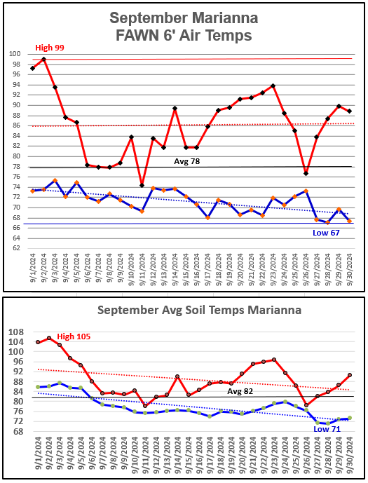
Morning low temperatures cooled off somewhat in September, but the daily highs were still pretty warm. The high 6′ air temperature in September was 99° in Marianna, on September 2, with lows that fell to 67° on the 28th and 30th. The average air temperature was 78°.
The -4″ soil temperature cooled significantly as well, going from a high of 105° on September 2 to a low temperature of 71° on the 27th and 28th. The average soil temperature was 82° in September. The trend line on the bottom graph shows the gradual drop in soil temperatures through the month.
–
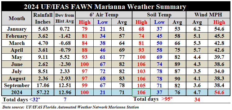
The Marianna FAWN Summary Table above shows how September temperatures compared to previous months. At this location, there were 14 of 30 days with recorded rainfall in September, so it is not too surprising that average temperatures were lower. The average 6′ air temperature dropped five degrees from 83° in August to 78° in September. However, he average -4″ soil temperature cooled eight degrees from 90° in August to 82° in September. Even with substantial rainfall from the outer bands from two hurricanes, the top September wind speed was only 38 mph, in Marianna.
–
3-Month Outlook
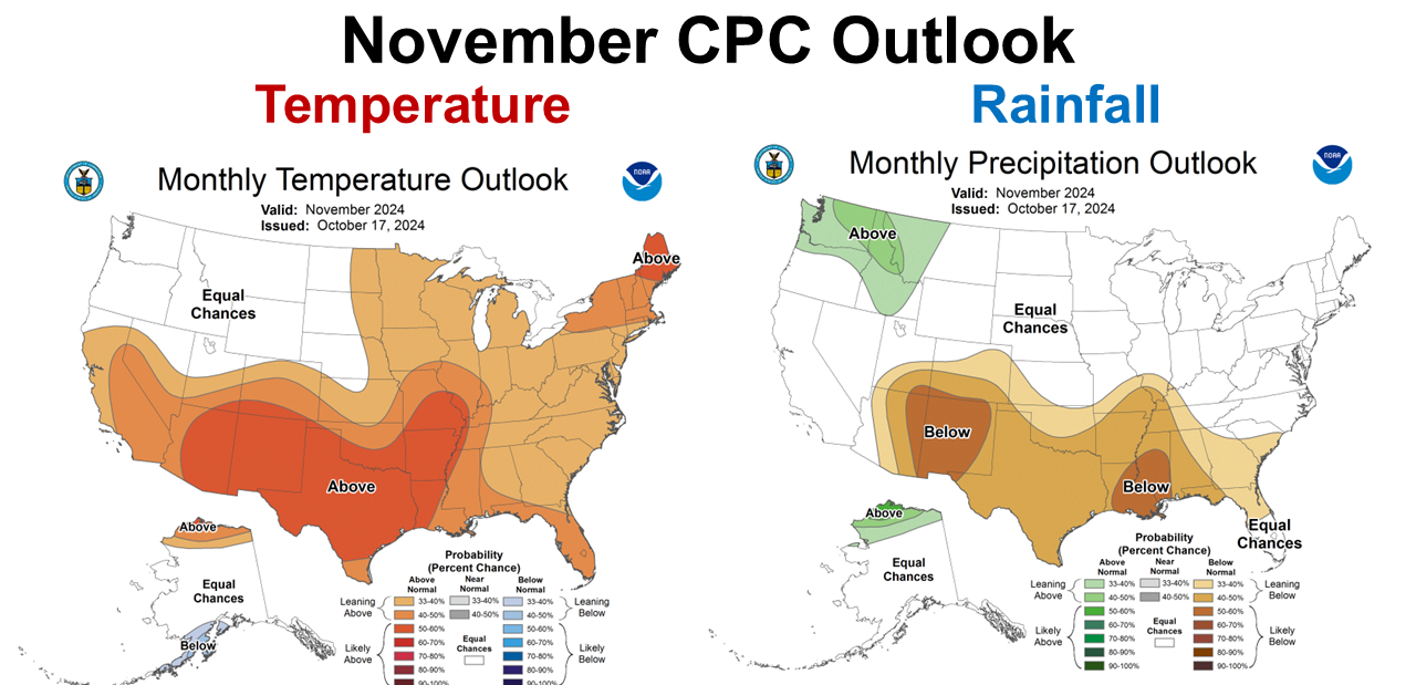
The November Outlook was released this week form the Climate Predication Center (CPC). The CPC is anticipating a warmer and drier than normal November. After a wet September, it appears both October and November will be dryer than average months.
–
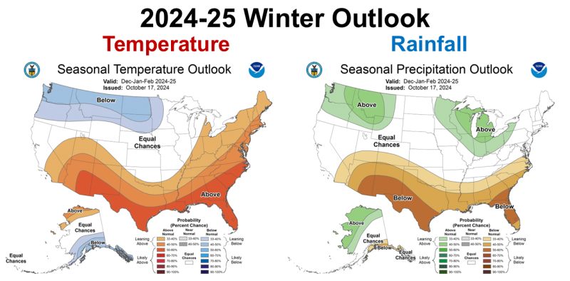
Same song, second verse for the entire winter outlook. The CPC is expecting warmer and dryer than normal conditions to persist through the entire winter. October has been extremely dry, so this forecast does not bode well for strong winter forage or cover crop production.
–
La Niña Watch
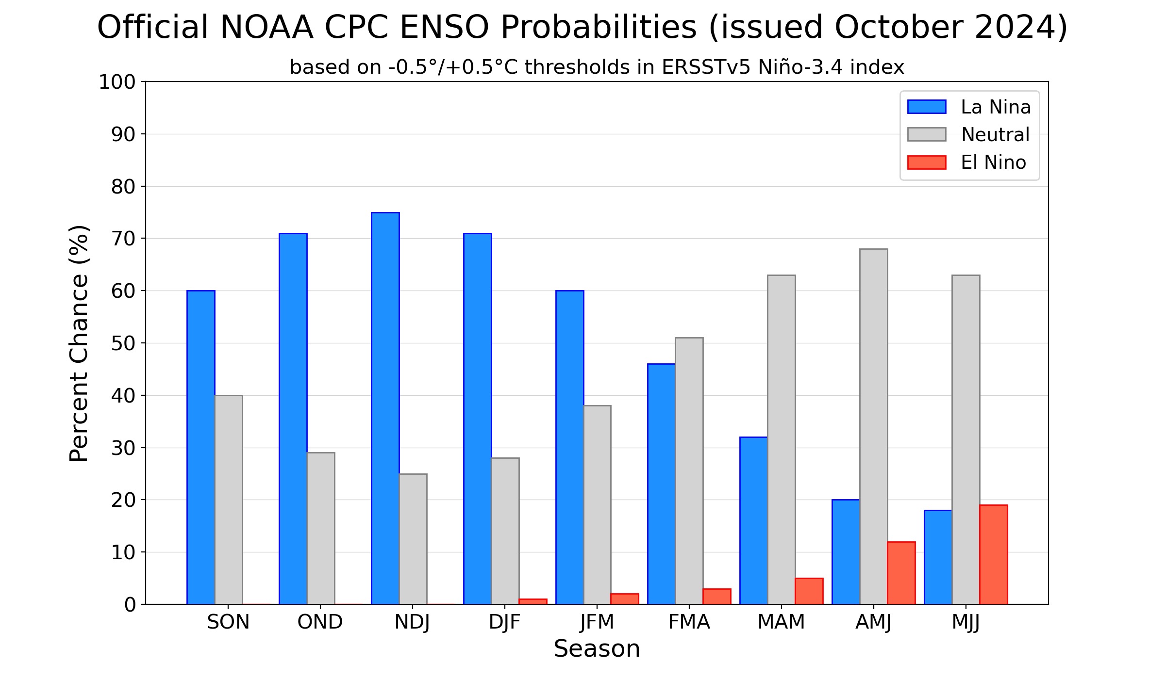
Even though the CPC has not officially announced that La Niña has begun, based on their outlook maps above, they are clearly banking on the effects over the next four months across Florida, and the rest of the southern states. The highest probability (over 70% chance) for La Niña is expected from October through February.
During September 2024, ENSO-neutral continued with near-average sea surface temperatures (SSTs) observed across most of the central and eastern equatorial Pacific Ocean. Similar to this time last month, the latest weekly Niño indices ranged from +0.2°C (Niño-4) to -0.4°C (Niño-1+2; Fig. 2). Below-average subsurface temperatures persisted across the east-central and eastern equatorial Pacific Ocean. Low-level wind anomalies were easterly over the east-central equatorial Pacific, and upper-level wind anomalies were westerly over the eastern Pacific. Convection was near average over Indonesia and was slightly suppressed over the Date Line. Collectively, the coupled ocean-atmosphere system reflected ENSO-neutral.
The IRI plume predicts a weak and a short duration La Niña, as indicated by the Niño-3.4 index values less than -0.5°C. The latest North American Multi-Model Ensemble forecasts were warmer this month, but still predict a weak La Niña. As a result of the warmer predictions and the recent weakening of equatorial trade winds, the team still favors a weak event, but has lowered the chances of La Niña. A weaker La Niña implies that it would be less likely to result in conventional winter impacts, though predictable signals could still influence the forecast guidance. In summary, La Niña is favored to emerge in October-November (60% chance) and is expected to persist through January-March 2025. October 2024 ENSO Outlook
 –
–
What does this mean for Panhandle Farmers and Ranchers?
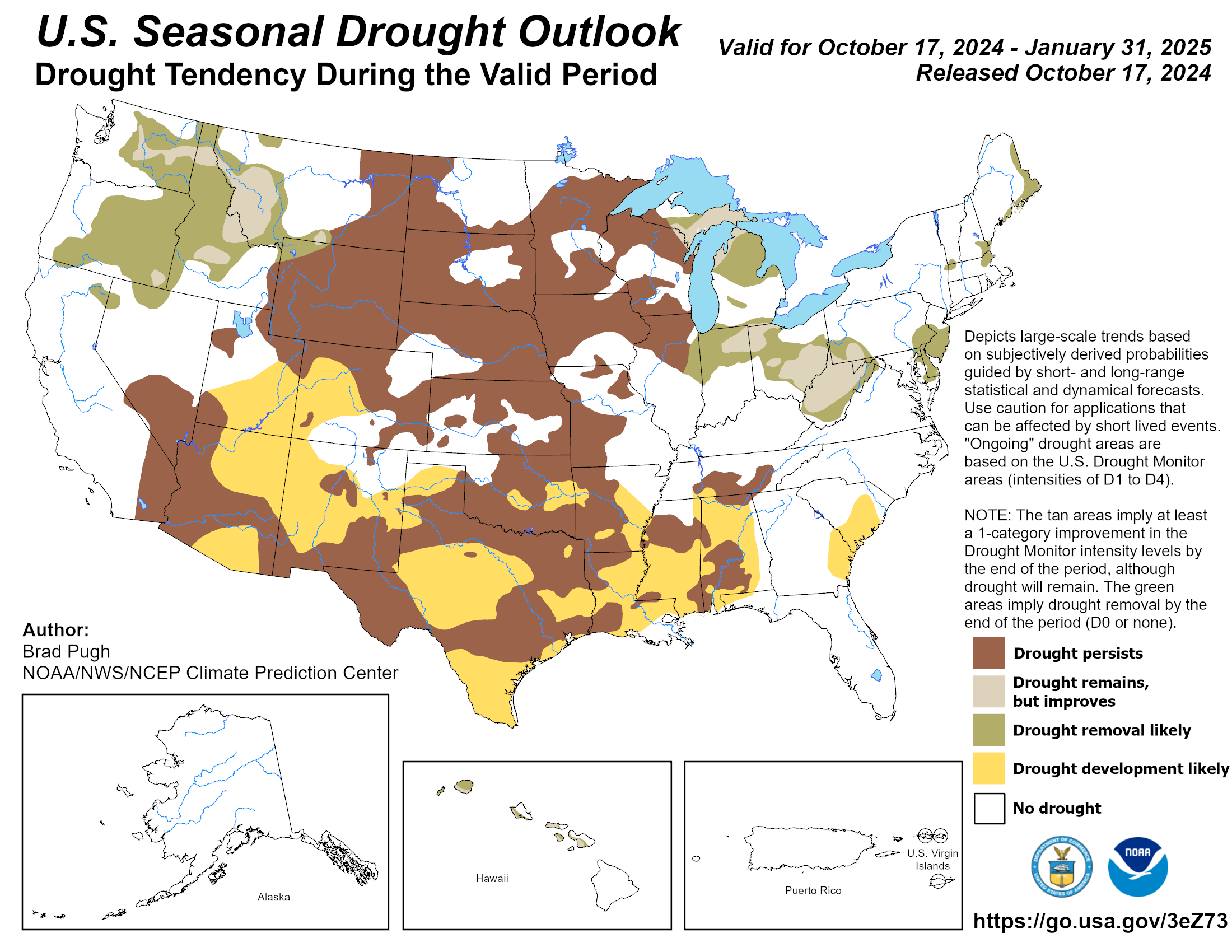
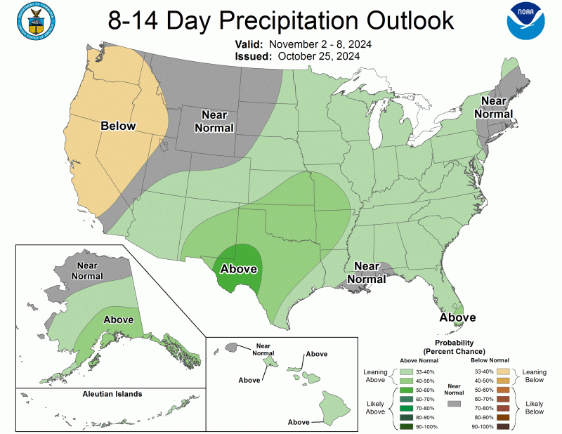 All of the available long-term forecast information does point to closing out 2024 pretty dry. This should prevent major harvest delays, but is not helpful for cover crops and forages grown without irrigation. September brought drought ending rainfall for much of North Florida from Hurricanes, but since then the spigot has shut off. The long-term forecasts don’t look good for strong winter forage and crop production. The Seasonal Drought Outlook below shows that much of the South will be experiencing drought through the end of January. There is an expectation of moisture in early November (right), so this may be an opportunity to get winter grazing or cover crop seeds some moisture to germinate. The long-term outlook does not mean that no rain will fall this winter, but there is an expectation that La Niña will the reduce the normal flow of frontal rains moving southward. This is probably not the year to overseed pastures with winter annuals, as even dormant grasses compete for moisture. I would also suggest being selective about planting fields that tend to hold moisture well. A warm fall could also mean that armyworms stay active longer, so keep a close eye on the annual grasses and small grains you decide to plant. The CPC is predicting a weak La Niña, so hopefully the affects will be less severe than the ones we endured in recent years.

demayo@ufl.edu - 850-482-9620
Follow me on Twitter
@UFCowman
- 2025 Weather Summary and 2026 1st Quarter Outlook - January 16, 2026
- 2025 Average Farmland Rental Rates, Lease Agreements, and Worker Wages Summary - January 16, 2026
- Friday Feature:1954 How to Dial Your Phone - January 16, 2026