
 Rainfall
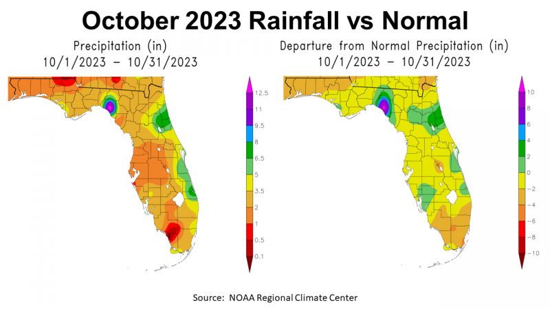
October was another dry month for much of Florida. NOAA provides maps with estimates of rainfall for the month as well as a comparison to average precipitation. The map to the left above shows the range of rainfall for the state. In the Panhandle, October’s estimated rainfall ranged from 0.5-1″ red, 1-2″ orange, 2-3.5″ gold, and a small area that received 3.5-5″ in yellow. The map to the right shows how this year’s rainfall totals compare to historic average in October. The Panhandle ranged from -2 to -4″ below average in orange, 0-2″ below average in yellow, with just a small area in green that was 0 to 2″ above average for the month.
–
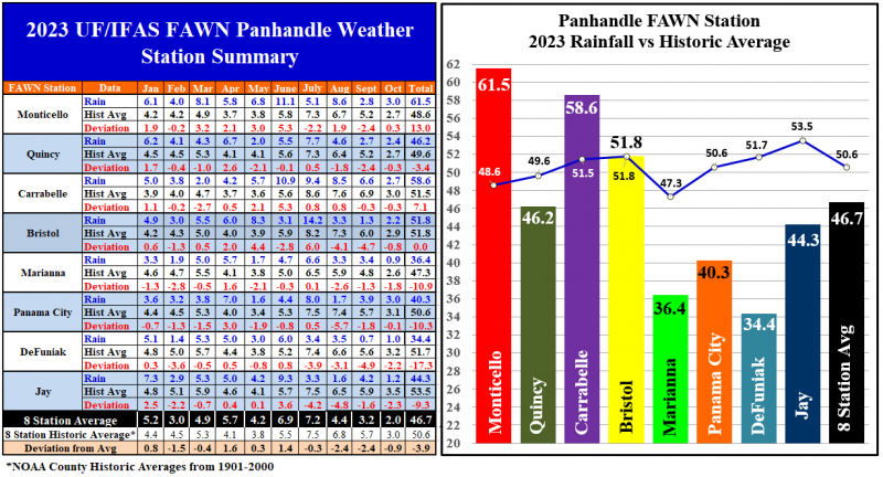
The Florida Automated Weather Network (FAWN) stations provide a more precise rainfall history for October. The wettest location was in Monticello with 3″, which was 0.3″ above historic average for that location. Contrast that with the 0.9″ that was recorded at Marianna, -1.8″ below average. The average for all eight FAWN stations was 2″, which was -0.9″ below normal for October.
Through 10 months of 2023, The DeFuniak Springs location was the driest at 34.4″, -17.3″ below average for Walton County. Contrast that total with the 61.5″ collected thus far at Monticello, which was 13″ above average for Jefferson County. The 10-month average for all eight stations was 46.7″, which was -3.9″ below normal in the region.
–
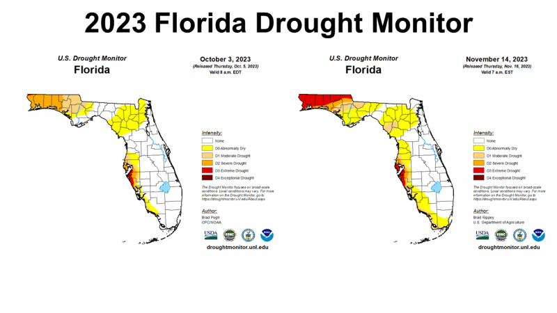 No real surprise, based on the data above, the drought got much worse in October. In the map above to the left, you can see that the Western Panhandle ranged from Abnormally Dry (yellow), Moderate Drought (tan), to Severe Drought (orange) at the start of October. This week’s Drought monitor shows a much more widespread Extreme Drought (red) in the region. At this point, every county from Jefferson west is included in the drought categories. Slow, soaking rain pushed through the region this week, so we may see a positive change in next week’s map.
–
Temperatures
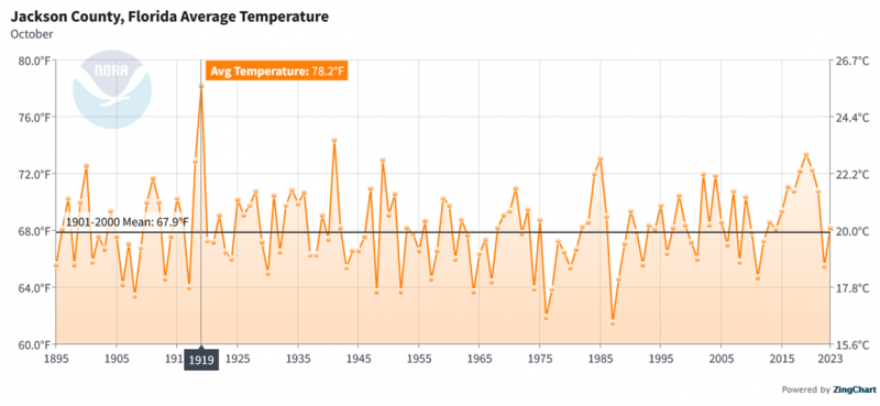
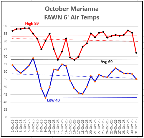 October 2023 did provide welcomed relief from the heat of the Dog Days that proceeded it. The High for the month of 89° came on October 4th and 5th. The low of 43° came just a few mornings later on October 9th. The average for the Marianna FAWN station was 69°. While October 2023 was warmer than average in many areas, you can see from the chart below this average temperature was no where near as warm as October 1919, when the average was 78°. The trend the past few years was higher than average, but this chart shows the historical fluctuation from year to year.
 –
–
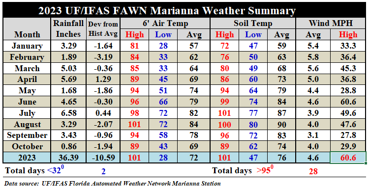
Compared to September, the average air temperature dropped nine degrees from 78° to 69° in October, and 15 degrees from the 84°average in August. The average soil temperature also dropped nine degrees from 83° to 74°. The soil cooled 16° compared to the 90° average in August.
–
 Winter Climate Outlook

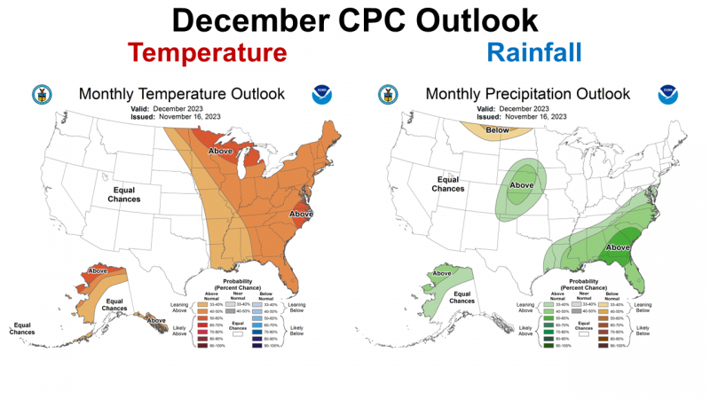
Looking ahead to December, it is clear the Climate Prediction Center (CPC) is expecting El Niño to kick in fully, with a high chance of above average rainfall in December. For December, the CPC is still expecting warmer than average temperatures for the Eastern U.S.
–
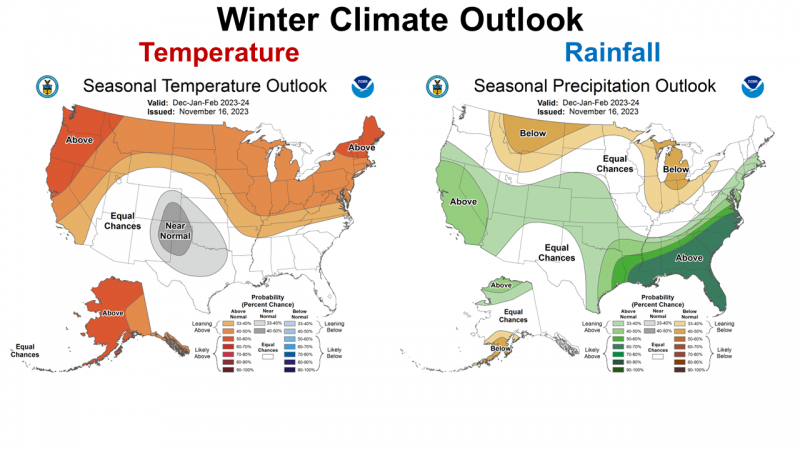 The December 2023 through February 2024 CPC outlook shows the classic El Niño forecast with a high probability of above average rainfall across the Southeastern states. Typically El Niño winters are cooler than average, but at least for the upcoming season, the CPC makes no prediction for temperatures with equal chances of above or below average.
–
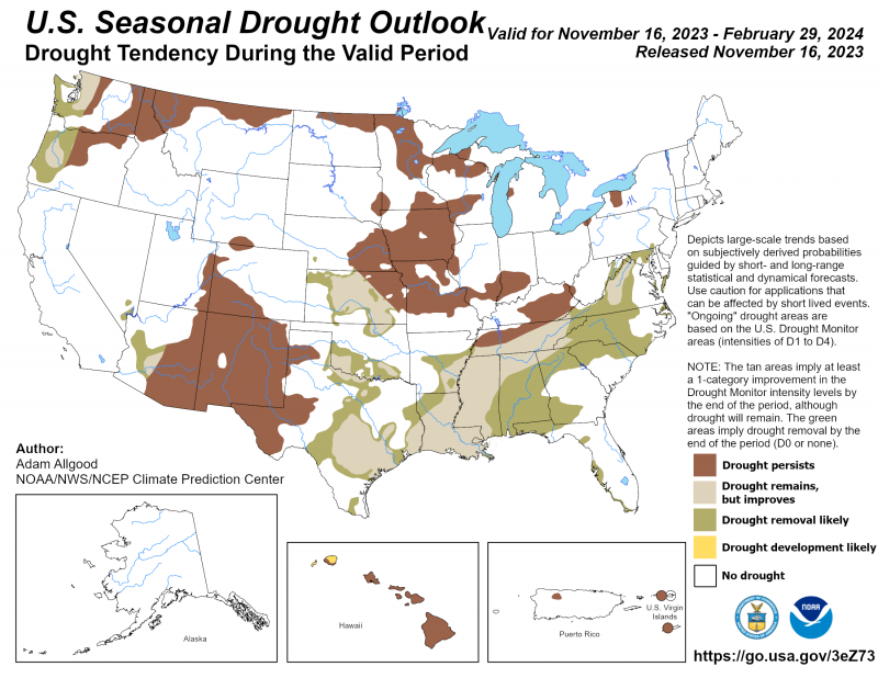
The good news is that the CPC is expecting El Niño to greatly improve the drought conditions across the Southeastern U.S. this coming winter. As bad as conditions have been in the Panhandle, there is hope in the coming months. This won’t help the crop yield and grazing losses of 2023, but it should restore soil moisture before planting next spring.
–
El Niño Advisory
A strong El Niño is expected with the possibility of a historically strong El Niño this winter. It is a strong possibility this could carry well into the 2024 growing season.
El Niño is anticipated to continue through the Northern Hemisphere spring (with a 62% chance during April-June 2024).
Above-average sea surface temperatures (SST) across the equatorial Pacific Ocean were indicative of a strong El Niño, with anomalies increasing in the central and east-central Pacific in the past month. Area-averaged subsurface temperatures anomalies increased slightly…which strengthened above-average subsurface temperatures in the central equatorial Pacific. Low-level wind anomalies were westerly in the east-central Pacific, while upper-level wind anomalies were easterly in the western and central Pacific. Convection/rainfall was enhanced around the International Date Line, extending into the eastern Pacific. Suppressed convection/rainfall strengthened around Indonesia. The equatorial Southern Oscillation Index (SOI) and the station-based SOI remained negative. Collectively, the coupled ocean-atmosphere system reflected a growing El Niño.
The most recent IRI plume favors El Niño to continue through the Northern Hemisphere spring 2024. Based on latest forecasts, there is a greater than 55% chance of at least a “strong” El Niño” (≥ 1.5°C in Niño-3.4 for a seasonal average) persisting through January-March 2024. There is a 35% chance of this event becoming “historically strong” (≥ 2.0°C) for the November-January season. Stronger El Niño events increase the likelihood of El Niño-related climate anomalies, but do not necessarily equate to strong impacts. In summary, El Niño is anticipated to continue through the Northern Hemisphere spring (with a 62% chance during April-June 2024). Climate Prediction Center
–
What does this mean for farmers and ranchers in the Florida Panhandle?
It does appear that the current drought will end this winter. The slow, gentle rain this past week with more promised for the week ahead should be enough for planting cover crops and cool-season forages. Growing conditions should improve in the coming months, so the best information available says that we can expect a wetter than normal winter that may well carry through the spring. After months of bad news, this forecast is encouraging. The damage to the 2023 pastures and crops is done, so this won’t help, but it does look more favorable for the start of 2024. I do think it is wise to plant cover crops and winter grazing. Better late than not at all. If we do have high rainfall periods, cover crops to prevent soil erosion could prove to be very valuable. With livestock producers forced to feed hay much earlier this year, growing your own forage for for spring grazing should be a good investment. It is possible hay will be in short supply later in the spring. If you don’t know if you have enough hay for winter feeding, I would encourage shopping around now to see what is available, rather than waiting to see and coming up short.

demayo@ufl.edu - 850-482-9620
Follow me on Twitter
@UFCowman
- May 2025 Weather Summary and Summer Outlook - June 20, 2025
- Friday Feature:The History of Angus Cattle - June 20, 2025
- Friday Feature:High Quality Legume Hay Production – Virtual Tour of Conrad Farms - June 6, 2025