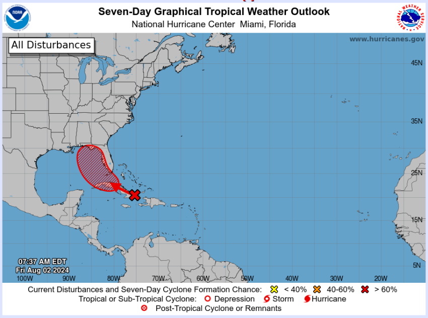
Source: National Hurricane Center
Pam Knox, Director of the UGA Weather Network and Agricultural Climatologist
As expected, the disorganized mass of thunderstorms that recently developed in the Atlantic is becoming more organized and has been designated as Investigation 97L (likely to be called Debby once it forms). It has a 40% chance of becoming a named storm in the next two days and a 70% chance in the next week. The latest tropical outlook shows that it is likely to form somewhere in the eastern Gulf of Mexico and then is expected to move north. The highest likelihood of impacts is to the right of the storm path, which means Florida, especially the west coast, and the northeastern Gulf coast, including southern Alabama and the Florida Panhandle as well as southern Georgia. Since the storm is so disorganized, the models cannot do a very good job of predicting where it will go, so it is important for any of you that might be in the area of potential impacts to be monitoring the storm development and tracking the predictions frequently over the next week to see if you will be affected. Do not just check it once but look at predictions at least a couple of times a day since many aspects of the storm are likely to change over time.
Here are some things to keep in mind. Florida could start to feel impacts, especially heavy rain, in the next two days as the storm pulls together. If it moves north towards the NE Gulf Coast, it is likely to bring impacts like high waves, rainy conditions, gusty winds, and possibly some small tornadoes. Right now the models are showing it could be over Georgia by Wednesday but the impacts will start occurring before then so preparations should be made by Tuesday morning. The timing is likely to change so getting ready earlier rather than later is a wise choice. The timing will be easier to determine once a named storm forms. Even if it does not organize into a named storm, it is likely to bring a mass of rain to the region. The regions that need to pay the most attention are western and northwestern Florida, southern Alabama and southern Georgia, especially the southeast parts, but this could change so keep watching. Some of the paths bring it northeast into South and possibly North Carolina later in the life of the storm, so if you are there, you also need to be watching.
While the models are not very believable before the storm has formed, there are some interesting model tracks that could affect the impacts of the storm longer-term. Some models have the storm slowing near the northern Gulf Coast and even doing loops due to a lack of steering currents. If that happens, rainfall amounts could be incredibly high. Other have it following a more conventional path towards the northeast after it make landfall. Most of the models are holding it at Tropical Storm or potentially Category 1 hurricane, but I worry about rapid intensification due to warm water in the Gulf, as happened with Hurricanes Michael, Ian, and Idalia, so be prepared for something stronger than we might initially expect.
If you have not already done your early season hurricane preparation (inventories, evacuation plans, etc.) then you should try to get those done soon. Other preparations include moving equipment, livestock, and vehicles out of low-lying areas where they could flood, getting fuel for generators if power is an issue for homes and dairies, removing things like lawn furniture that could become wind-borne missiles, and inspecting buildings and trees for dangerous limbs or loose shingles or boards. Take “before” pictures of crops to show what state they are in before the rain and winds hit to help with potential insurance claims, too, if you have the chance. You can find state specific guides for hurricane preparedness and recovery for agriculture, by using the following link:
–
Hurricane Preparation and Recovery Commodity Guides
–
I will try to provide an update at least once a day but I encourage you to follow the National Hurricane Center storm forecasts as well as your local National Weather Service office forecasts for more specific local forecast conditions as the storm gets closer. Most cell phone apps will not provide the detailed and timely information you need to make management decisions for your farms, businesses, and families.
