

Satellite image showing snow accumulation across the Southeast from Winter Storm Enzo, in January 2025. Credit: NOAA Historic January 2025 snowstorm in the Southern U.S.
Snow
Nobody in Florida has ever experienced anything like “Winter Storm Enzo,” (aka FLizzard or Snowmageddon) that brought record breaking snow to the Florida Panhandle in January 2025. For years we have heard weather forecasters talking about “Lake Effect Snow” that impacts places like Buffalo, New York, Chicago, Illinois, and other locations near the Great Lakes in the Upper Midwest of the U.S. In January 2025, the Panhandle had a generational snow storm from “Gulf Effect Snow.” People from a large area of the Coastal Southeast, that almost never see snow, got to enjoy or be frustrated by a phenomenon that has not happened in modern history. Many people, me included, wanted to know how much snow fell in different counties in the Panhandle, and how that compared to previous records.
–
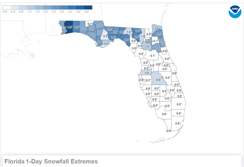
Florida record snowfall by county through 2024. Source: NOAA Snowfall Extremes by State
–
The map above shows the previous record snowfall from each Florida County through August 2024, but is scheduled to be updated on February 10th. I can assure you the numbers will be changing significantly soon, as this map is updated for the Florida Panhandle. The previous Florida state record was 4″ of snow on March 6, 1954, at the Milton Experiment Station, in Santa Rosa County, Florida. You can also see on the map that Okaloosa, Wakulla, Jefferson, Taylor, Suwannee, and Hamilton Counties had previous records with 3″ of snow, from February 1958.
–

January 21-22, 2025, Snowfall Estimate Map. Credit: Jordan McLeod, UAB Instructor of Meteorology
–
The very first snowfall estimates I saw on social media was the graphic above, created by Jordan McLeod, who is an Instructor of Meteorology, and the University of South Alabama, in Mobile, Alabama. If you click on the photo above, it will expand to full screen. This map does provide some good perspective on which areas received the highest totals.
The spatial footprint of heavy snowfall extends all the way from Houston, Texas to the Outer Banks of North Carolina! In fact, at least 5 inches of snowfall was observed in portions of each of the following states: Texas, Louisiana, Mississippi, Alabama, Florida, Georgia, South Carolina, and North Carolina. Jordan McLeod, USA Instructor of Meteorology
–
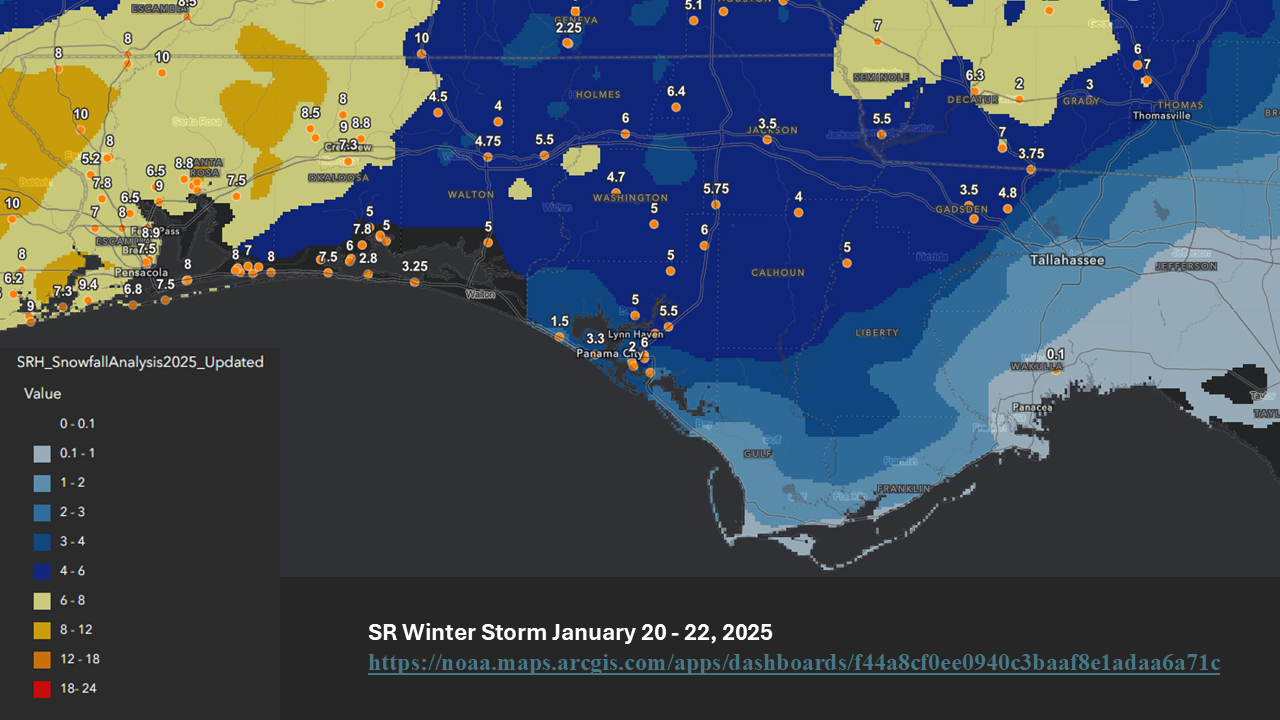
The National Oceanic and Atmospheric Administration (NOAA) also generated a map that included official reports from weather stations across the Southeast, along with zone estimates. Use the link in the caption to see the full scope of snowfall map, as the photo above was cropped down to only include the Florida Panhandle counties.
–

A few days after the big snowstorm, the National Weather Service Offices in Tallahassee, Florida and Mobile, Alabama published Public Information Statements with snowfall totals from each county in their coverage areas. The map above shows the high and low totals reported from each county in the Florida Panhandle, but the reports linked previously also shared totals from neighboring Georgia and Alabama Counties. Except for Jefferson County, all of these top snowfall reports will break the old county records.
–
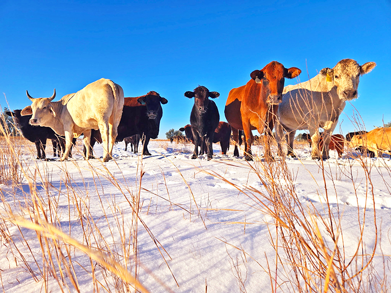
Hardin Land & Cattle cows experienced snow and 14° for the first time in their lives, on January 22, 2025. Credit: Terri Hardin, Jackson County Extension
–
Cold
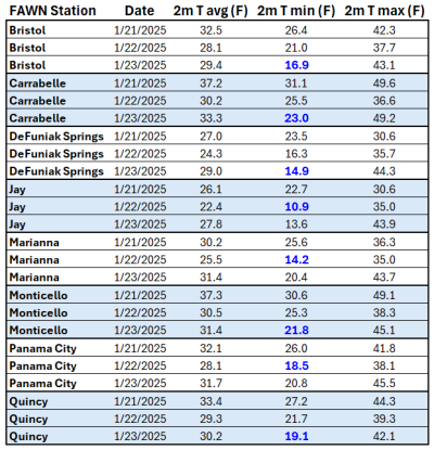 While it was fun to experience the snow (except for driving in it), you can’t have snow without the bitter cold. The snow and ice closed roads and caused some accidents, but the real impact to agriculture was not so much the snowfall, but the consecutive cold nights. The table to the right came from the eight Florida Automated Weather Network Stations in the Panhandle January 21-23. The coldest location, in addition to the high snowfall, was in Jay (formerly Milton Experiment Station), where the minimum temperature dropped to 10.9° on January 22. DeFuniak Springs and Marianna also fell below 15°. Even Carrabelle, that is close to the Gulf, dropped down to 23°.
For sure the cold and wet conditions were not favorable to livestock that were not well prepared for the cold stress from sleeping in damp snow and such a rapid drop in temperatures. Most herds in the area have finished calving, but newborn calves are most susceptible to cold stress. Oats is the forage or grain crop that is most susceptible to cold stress. For sure, these cold temperatures will have some impact. At the very least, the leaf blades above the snowline were frozen. It may take a few weeks to get back to full growth and production. You can read more about forage cold stress in Dr. Dubuex’s article, How are My Cool-season Forages Recovering from the Snowfall and Low Temperatures? Satsuma trees that were protected with cold protection irrigation, should be ok in the mid-teens, but expect major leaf and small limb loss away from the protective ice. But for sure there will be some damage to citrus trees in the region, especially in the western counties that got abnormally cold. Time will tell. Unlike windstorm damage, cold damage takes time to show the full effects. Those small stems are where fruit is set, so there could be significant yield losses in November.
–
Loss or Damage Assessment
If you had losses or damages from January 20-23, 2025, be sure to write down issues you see and take photos to document the damages. You should report losses to your local Farm Service Agency (FSA), so they can develop a county damage report. This data is necessary for any potential disaster declaration.
The University of Florida’s Institute of Food and Agricultural Sciences (UF/IFAS) has a team of researchers and staff that manage the Economic Impact Analysis Program (EIAP) to provide damage assessments from severe weather events in Florida . This effort, lead by Christa Court, UF/IFAS Food and Resource Economics Department, surveys farms post-event for damage to develop total loss estimates for the Florida Department of Agriculture. This team has been primarily focused on hurricanes in the past, but is also seeking input from damages or losses from Winter Storm Enzo. The current Enzo survey is part of ongoing UF/IFAS research tracking the effects of severe weather and other hazards on the state’s agricultural industry. Survey participation is voluntary and should only require 10 and 20 minutes to complete. Your answers will be kept confidential. If you need help developing a damage assessment report from your farm, contact your local County Extension Agriculture Agent.
Winter Storm Enzo Agricultural Losses/Damage Survey: go.ufl.edu/EnzoAgImpacts

demayo@ufl.edu - 850-482-9620
Follow me on Twitter
@UFCowman
- Ranch Record Keeping for Annual Analysis & Innovation - January 23, 2026
- Friday Feature: 2026 Farm Dog of the Year - January 23, 2026
- 2025 Weather Summary and 2026 1st Quarter Outlook - January 16, 2026