
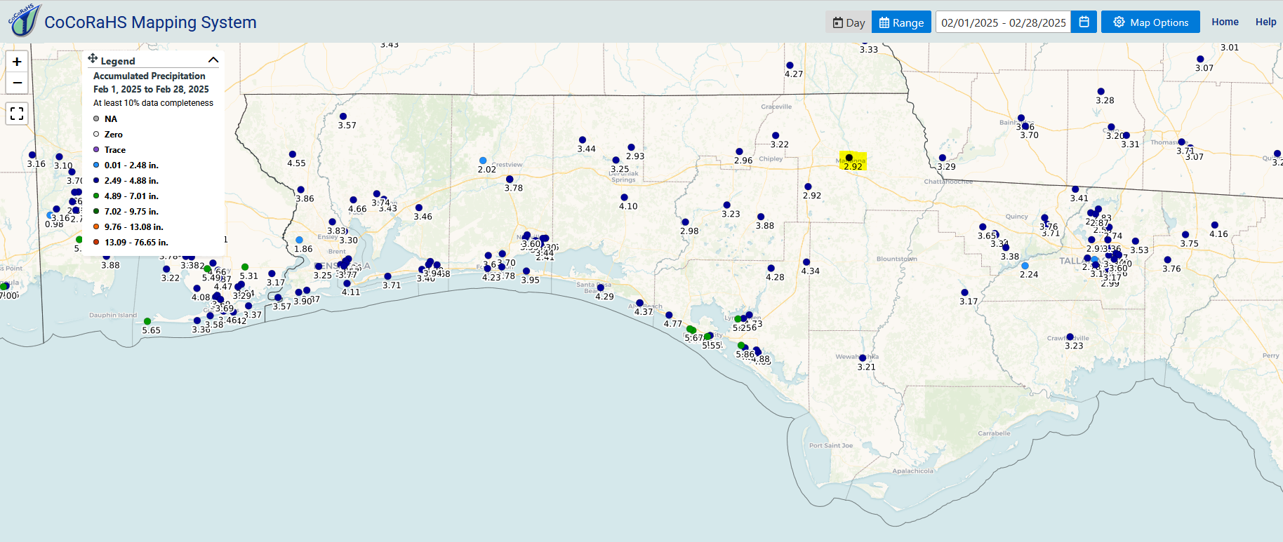
Figure 1. February 2025 rainfall from participating volunteers in the Florida Panhandle. Click on image to enlarge for full screen viewing.
I have been a Volunteer Precipitation Reporter for the Community Collaborative Rain, Hail and Snow Network (CoCoRahs) since November 2018, with the station ID of FL-JK-6 (Florida – Jackson County – station #6 highlighted in the map above). Every day the CoCoRahs network shares a map similar to this for the rainfall reported that day, but through the website, you can also generate a map like Figure 1. above for a whole month, or up to the past 90 days. Notice how few reports are currently coming in from rural farming areas in the Panhandle. Only the program managers know who shares the data from each site, so your personal information is not available to the public.
This is a great program, because it provides a database to store your rainfall records and even allows you to go back and compare to NOAA average rainfall for your county. Through this program, you have your own online dashboard of the data collected at your location that is easily accessible through the CoCoRahs website. Figure 2. below is an example of the type of information that can be generated that shows the rainfall and snowfall (I had never reported that before) information measured at the single site this winter.
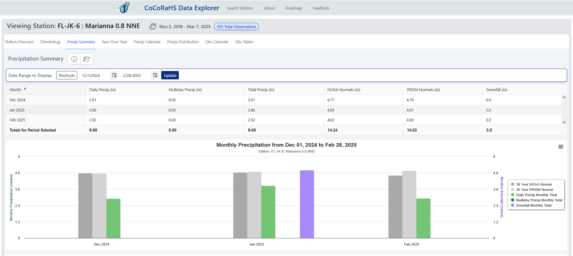
Figure 2. December 2024 through February 2025 rain and snow reported from a single station compared to NOAA and PRISM reported normal precipitation for the past 30 years. Click on image to enlarge for full screen viewing.
–
Why should you become a volunteer reporter?
The Community Collaborative Rain, Hail and Snow Network (I agree, CoCoRaHS may well be the longest acronym in the history of mankind) is a network of people all over America that voluntarily report daily precipitation (rainfall, snowfall, or hail). Instead of maintaining a written record, or trying to keep up with a spreadsheet, the CoCoRahs app makes recording and tracking your daily rainfall very easy. In return, the National Weather Service and other Meteorologists have more data to verify impacts of storms, or drought than just their standard weather stations at airports and larger cities. Plus, each day you can see the data from other volunteers reporting from your area. We all know the frustration of receiving much different rainfall amounts than what is reported from larger cities or automated weather stations in the area. With the CoCoRaHS system, you can track your site-specific rainfall just by entering the data from your gauge into an app on your smart phone, (or through the website using a computer for you flip phone lovers) in a matter of seconds.
There is no fee for participating in this program. The only requirements for participating are that you register your site and location, report rainfall at a consistent period every day (7:00 AM is what is recommended), and that you purchase a high capacity ,4″ diameter gauge that can hold up to 11″ of rainfall – CoCoRaHS Gauge. These CoCoRaHS manual gauges are very accurate. Tests conducted in Colorado over three decades indicate that the CoCoRaHS gauge has a collection efficiency of 101-105% compared to the standard National Weather Service (NWS) gauges in side-by-side measurements. There is also an option to report multiple days, if you are away on trip, but these reports are kept separate from the daily precipitation reports. You can also report later than 7:00 AM on days that you are not able to check the gauge around that time, but your data may not be included in the online maps generated for that day. It is also possible to report from more than one gauge, if you wanted to have more records from different points on your farm, but this will require a special request when you set up your account.
–
So what does this have to do with farming?
There are several reasons that participating in this program could be of great benefit to farmers and ranchers. Using the CoCoRaHS phone app greatly simplifies keeping rainfall records, and the only expense are the high-capacity rain gauges, which won’t overflow. I would suggest ordering one of these even if you don’t participate in the CoCoRaHS program, just because it will not overflow if you get more than 5 or 6″ of rainfall at a time. There is real value in having a database of multiple years of rainfall records kept at no charge on the Internet with relatively easy access.
1. Automated Record Keeping
Perhaps the greatest benefit for becoming a voluntary CoCoRaHS member is that rainfall data is entered each day in a matter of seconds but can be accessed for each location or by county. The software keeps track of your rainfall for you and can be accessed for specific periods of time. You can access the data using the Total Precipitation Summary, and setting the time frame, state, and county you want to look at data from.
–
2. Documentation of Rainfall
Throughout my career, there have been multiple occasions when farmers have needed rainfall data for reports or issues they dealt with. Whether you need to justify irrigation use for the Water Management District, to settle a dispute with crop insurance, or to share with a seed company for a refund on seed with poor germination, it is good to have documentation to prove the amount of rainfall received at your farm. This system makes it automated and does the math for you. The CoCoRaHS website gives you access to your data fairly easily through the Station Precipitation Summary Report.
–
3. Rainfall is Critical for Farming
With or without irrigation, the amount of rainfall received plays a huge role in successful crop and forage production. While the amount of rain you receive is totally out of your control, it is helpful to compare production with a rainfall history from year to year. While we can certainly get data from the FAWN system, these stations may be located some distance away from your individual operation. With the data summary from your own gauge, you can easily compare rainfall history at your own location.
–
How to Get Started
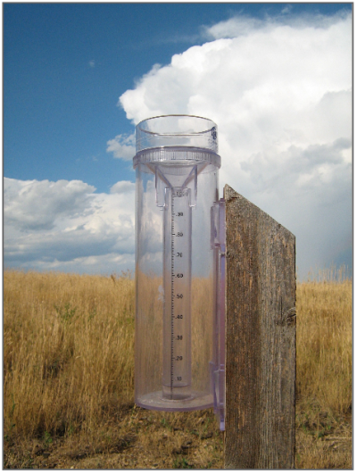
The 4″ diameter rain gauge has an 11″ capacity, and is almost as accurate as the high-end automated gauges the National Weather Service uses. Credit: CoCoRahs
You can become a volunteer too, so we have more information available with more varied rainfall data collected in the Panhandle. To be involved it only requires four simple steps:
- You need to order a 4” diameter rain gauge that can handle up to 11” of rainfall. – These gauges are currently on sale for $42 each from Weather Your Way
– - You will need to identify a location where you want to install your gauge. Then you need to use a tool such as Location Coordinates: in decimal degrees: Latitude (40.5993) : Longitude (-105.1152) : I used the compass app on my phone for these.
– - Complete the volunteer application: https://www.cocorahs.org/application.aspx
– - Download the app from the Google Store or Apple Store, depending on the type of phone you have, that you will be reporting rainfall or 0.00” on a daily basis. The app also provides an option for multiple day reporting, so you can still upload rainfall data when you return from trips or vacations.
– - Once you have purchased a gauge and mounted it to a post and completed the application, CoCoRahs will send you the username and password to start reporting the rainfall data you collect each day.

demayo@ufl.edu - 850-482-9620
Follow me on Twitter
@UFCowman
- 2025 Weather Summary and 2026 1st Quarter Outlook - January 16, 2026
- 2025 Average Farmland Rental Rates, Lease Agreements, and Worker Wages Summary - January 16, 2026
- Friday Feature:1954 How to Dial Your Phone - January 16, 2026