
Rainfall
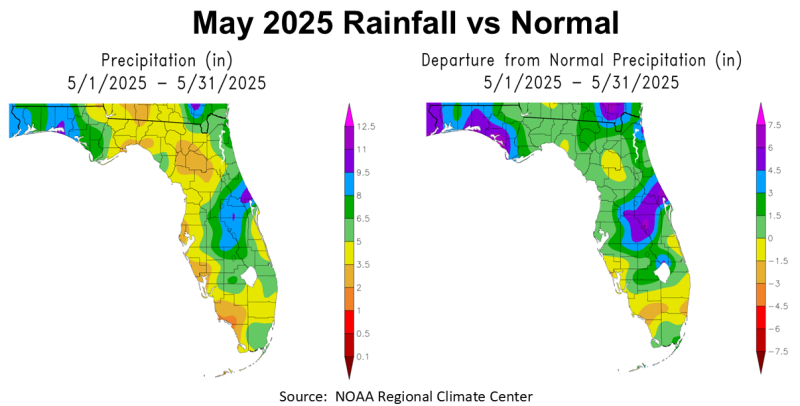
May was a pleasant surprise for much of the Panhandle, except for the western counties that had much higher than normal rainfall. The map to the left provides an approximate total for the month, ranging in the Panhandle from 2-3.5″ (tan), 3.5-5″ (yellow), 5-6.5″ (light green), 6.5-8″ green, to 9-9.5″ blue, with a small pocket in Walton County that had 9.5-11″ (purple). The map to the right shows how May 2025 rainfall compared with historic average. The entire Panhandle was above average, ranging from 0-1.5″ above average (light green) to more than 4.5″ above average (purple). This map also shows that South Florida (south of Lake Okeechobee) remained drier than normal in May.
–
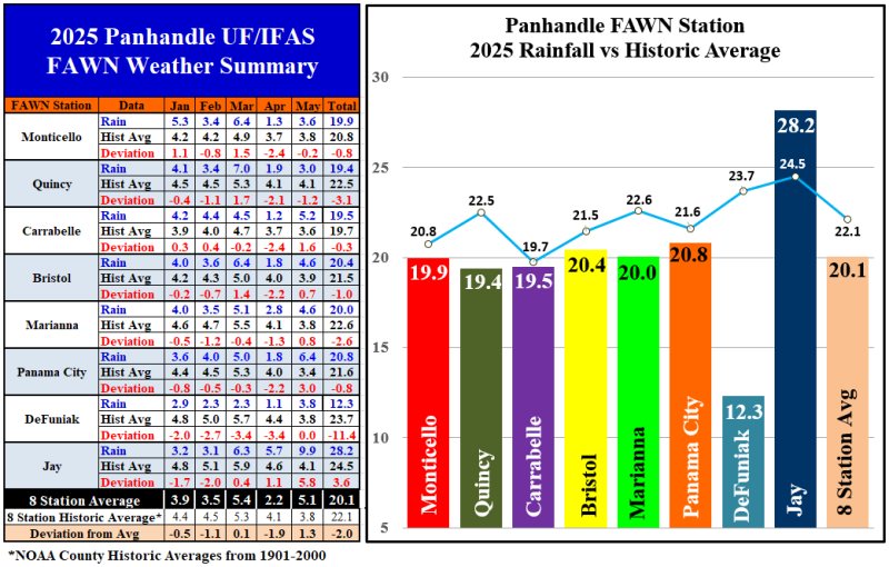
The data from the eight Florida Automated Weather Network (FAWN) stations show more precise variation across the Panhandle. The wettest location was Jay with 9.9″, that was 5.8″ higher than normal in May. The driest location was at Quincy where only 3″ were recorded, and was -1.2″ below average. There was a 7″ variance for a single month. The average of all eight FAWN Stations was 5.1″, which was 1.3″ above average.
From January through May, the eight FAWN Stations averaged 20.1″, which was -2″ below normal. The wettest location was in Jay with 28.2″, that was 3.6″ higher than average. Compare that with only 12.3″, that was recorded two counties over in DeFuniak Springs, -11.4″ below normal. The bar chart above shows the average rainfall line in comparison with the actual recorded rainfall. It shows that the Jay station was the only location the Panhandle that was above average thus far in 2025.
–
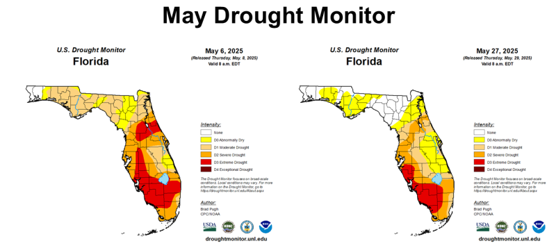
As would be expected, May rainfall did bring drought relief to North Florida. The map to the left shows how dry Florida was near the beginning of May, while the map to the right shows soil moisture conditions near the end of the month. June rainfall has continued this trend through the first two weeks, but even so, most of the Florida Peninsula is still experiencing drought.
–
 Temperatures
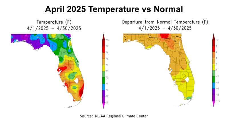
Temperatures heated up rapidly in May. You can see in the map above that the areas that had higher rainfall totals were also cooler overall for the month. Compared to historic average, however, the map to the right shows that most of Florida was 2-4° warmer than normal.
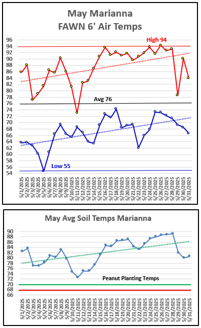
We started the month with highs in the 80s, but reached the 90s on May 15. The chart to the right from the Marianna FAWN Station shows the high for the month was 94° on May 16, 24, and 26. The low was 55° on May 5th. The average for the month was 76°.
The chart on the bottom right shows average soil temperatures. The entire month of May was well above 70°, which is the optimum temperature for peanut seed germination. The peak average soil temperature was 89° on May 26-28, however, soil temperatures highs were over 100° on May 24 and 28.
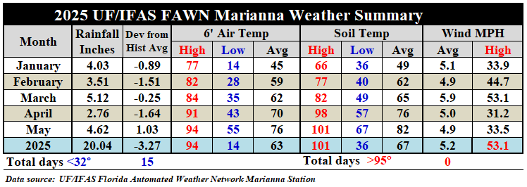
When compared to April, you can see in the table below that the average air temperature rose 6°, from 70° in April to 76° in May. The average soil temperature also rose 6°, from 76° in April to 82° in May. Even though there were a number of rain storms that rolled through, the top wind speed recorded was 33.5 mph at that location.
 –
–
Climate Outlook
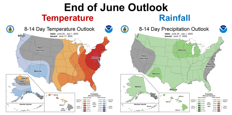
On June 17th, the Climate Prediction Center (CPC) shared a short-term climate outlook for the remainder of June. The hotter and wetter than normal weather trend is expected to continue. There is no doubt that summer is here to stay.
 –
–
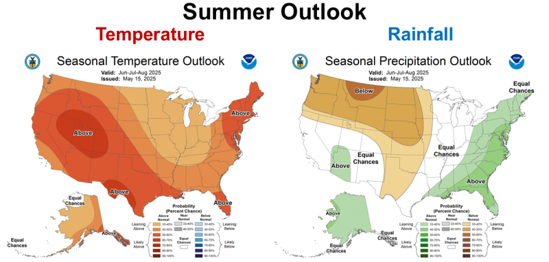
The CPC’s Summer Outlook shares a similar expectation for Florida with an even greater expectation for above average precipitation and temperatures. So, it does not appear that we are facing a third straight year of a dry growing season. Too wet is not great for crops either, so we can hope for that sweet spot of more than last season, but not too much all at once.
 –
–
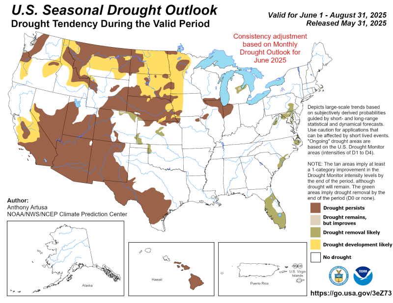
Based on this long-range forecast, the CPC is expecting drought removal for the entire state of Florida by the end of August. Basically the entire eastern U.S. other than a small pocket in Indiana and Illinois is expected to be drought free by summer’s end.
 –
–
 ENSO Watch
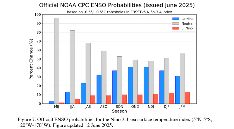
The CPC issued their most current ENSO Diagnostic Discussion on June 12. ENSO Neutral is expected through the end of the year, but with an increasing chance of La Niña later this fall and winter.
In the past month, ENSO-neutral conditions persisted, with sea surface temperatures (SSTs) near average over most of the equatorial Pacific Ocean. The latest weekly Niño index values ranged from -0.1°C to +0.4°C. Subsurface ocean temperatures were near-to-above average, with above-average subsurface ocean temperatures at depth in the central and western Pacific. For the month, low-level winds were easterly over the east-central Pacific, while upper-level winds were mostly near average across the equatorial Pacific Ocean. Convection was enhanced over Indonesia. Collectively, the coupled ocean-atmosphere system in the tropical Pacific reflected ENSO-neutral.
The IRI and North American Multi-Model Ensemble predictions indicate ENSO-neutral is most likely through the Northern Hemisphere winter 2025-26. The forecast team also continuously favors ENSO-neutral through early 2026, with smaller chances that La Niña could form during winter 2025-26. In summary, ENSO-Neutral is likely in the Northern Hemisphere summer 2025 (82% chance in June-August) and may continue into winter 2025-26, though confidence is lower (48% chance of Neutral and 41% chance of La Niña in November-January). CPC ENSO DIAGNOSTIC DISCUSSION – June 12, 2025
–
What does this mean for Panhandle farmers and ranchers?
This is shaping up to be a wetter growing season after a hot and dry start. The CPC is fairly certain that the majority of Florida will have a wetter than average summer, with less certainty south of Lake Okeechobee. Drought is not expected to be an issue this summer with ENSO Neutral. Neutral hurricane seasons are typically more active, so tropical storms could be an issue in Florida again this year. It is too early in the season to strongly predict the ENSO affect on fall and winter climate, but at least at this point, Neutral is still the highest expectation. In wetter growing seasons fungal diseases are typically more of an issue with frequent rainfall preventing timely preventive fungicide applications. Weeds are also typically more challenging to control in wet years as well, so it will be important to take advantage of spray windows when available. Hay harvest may be more challenging this year as well, so baleage may be a more viable option, especially over the summer months. At this point, all of the forecasts seem positive for good crop yields even in dryland fields, unless we have tropical systems that dump excessive rainfall. Crop prices this year are low, so hopefully above average rainfall will translate into above average yields. Check back in next month to get a better idea on climate expectations later in the year.

demayo@ufl.edu - 850-482-9620
Follow me on Twitter
@UFCowman
- 2025 Weather Summary and 2026 1st Quarter Outlook - January 16, 2026
- 2025 Average Farmland Rental Rates, Lease Agreements, and Worker Wages Summary - January 16, 2026
- Friday Feature:1954 How to Dial Your Phone - January 16, 2026