
Rainfall
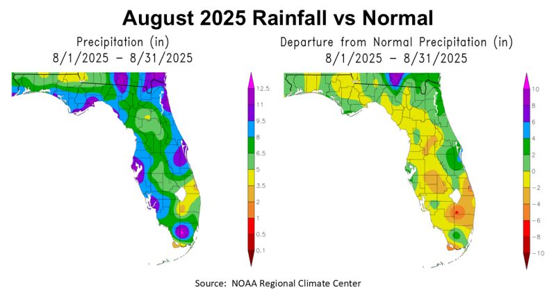
August 2025 was an interesting month with above average rainfall in the first half of the month, particularly near the Gulf Coast. But, in the second half of the month some areas dried back out fairly rapidly. The map above to the left shows total estimated rainfall in August ranging from 3.5-5″ in yellow, to 9.5-11″ in purple along the coast. The map to the right above shows how August 2025 compared with historic average. All of the areas shaded in yellow, tan, or orange were below average, and in light or dark green above average.
–
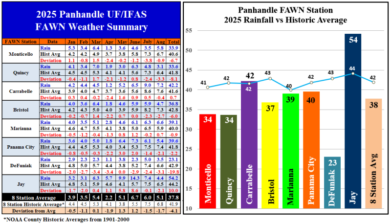
The eight Florida Automated Weather Network (FAWN) stations show more precise variation in rainfall across the Panhandle. Only the station at Marianna was above historic average in August. The highest total recorded was the 7.2″ at Carrabelle, that was still -0.4″ below normal. Quincy was the driest location, with only 3.1″, -3.3″ below average. The average for all eight stations was 5.1″, which was -1.7″ below normal for the month.
From January through August, the station in Jay was 10″ higher than normal, with a total of 54.2″. Contrast that with only 23.1″ total in DeFuniak Springs, which was -19.8″ below average. The average of all eight stations through eight months was 37.8″, 4.1″ below normal. Those two stations are ~70 miles apart, so that is very strange.
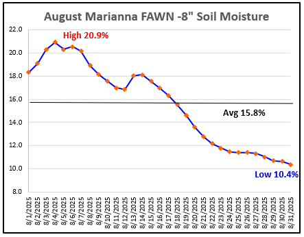 The 8″ Soil moisture chart to the right, from the Marianna FAWN Station, shows the range in soil moisture from the beginning of the month to the second half of the month. Soil moisture at Marianna ranged from a high of 20.9% on August 4th down to 10.4% on August 31. The average soil moisture in August was 15.8% in Marianna, up 5% from July. This new data on soil moisture has been interesting to watch so far in 2025. So, while it did cool off considerably towards the end of August, the dry air behind the cold front prevented rainfall and really dried the soil out significantly at the -8″ level. It also clearly shows that while August was above average rainfall at this location, it was not distributed well, so irrigation was clearly needed at the end of the month.
–
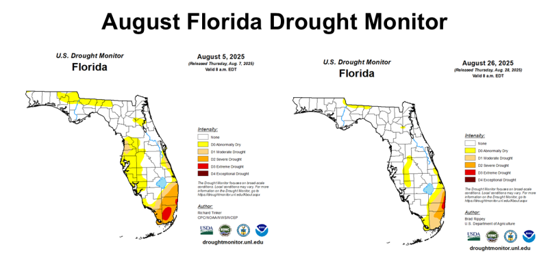
While the rainfall was slightly below average across Florida, much of the state saw drought improvement from the beginning to the end of August. In the Panhandle, only the area along the Georgia border was in the Abnormally Dry category at the end of August. But with soil moisture dropping at month’s in, and limited rainfall so far in September, don’t be surprised if several Panhandle counties are moved back to Abnormally Dry category in the coming weeks.
–
Temperatures
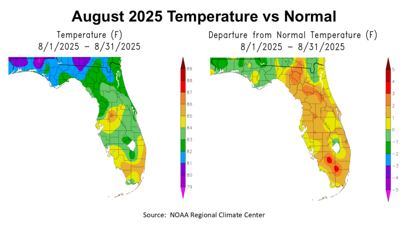
When you look at NOAA estimated average temperatures, it was a relatively mild August in the Panhandle. The map to the right shows that the areas of the Panhandle that received higher rainfall totals were also slightly cooler than normal. Almost all of the Florida Peninsula was somewhat above average in August.
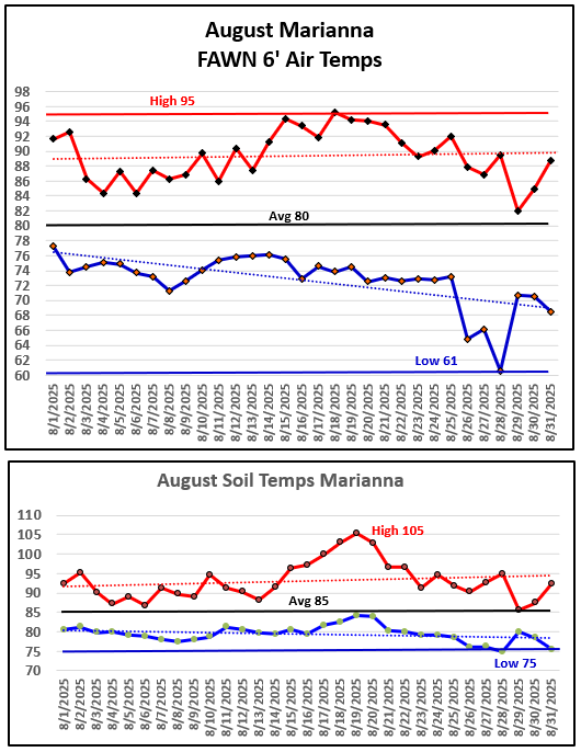 When you look at the range of daily temperatures from the Marianna FAWN Station in the chart to the right, you can see that overall August was a hot month, but it did cool down considerably the last week of the month. There was a big drop in the early morning temperatures, with a low of 61° on August 28. The High for the month was 95° on August 18, but that was the only day above 95°. The average for August at Marianna was 80°.
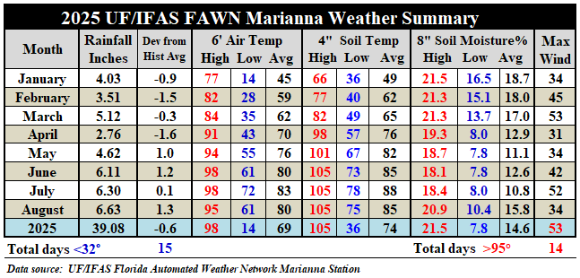
The soil temperature at the -4″ depth averaged 85°. The high for the month was 105°, on August 19, and the low of 75°, on August 28.
The chart below shows the average air temperature in Marianna dropped 3°, from 83° in July to 80° in August. Soil temperatures also dropped 3°, from 88° in July to 85° in August. Notice the difference in soil moisture in August vs July as well, as it improved from an average of 10.8% in July to 15.8% in August.
 –
–
 Climate Outlook
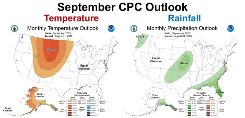
The Climate Prediction Center (CPC) made some changes in their outlook for September verses previous months. With a cooler than average August over much of the Southeast, they are not expecting higher than normal temperatures in September for the majority of the U.S. The CPC is still predicting higher than average rainfall in September. Through much of the growing season, the CPC has been wrong in their predictions for much of the Panhandle, but we know with tropical storms, September can be much wetter than normal.
–
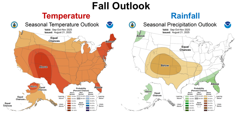
Interestingly, the CPC is forecasting a warmer than average fall. They also are predicting higher than average rainfall across Florida. October and November have historically been drier months across Florida, so above average may still not mean a wet fall that slows crop and hay harvest.
–
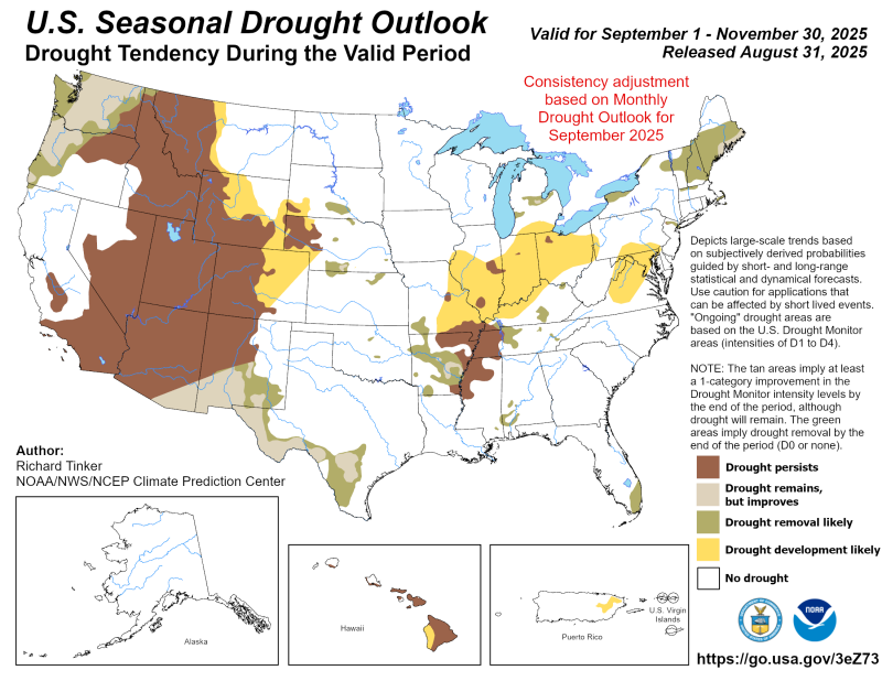
The CPC is expecting all of Florida to be drought free at the end of fall. The southern tip of Florida has been really dry all year, so we will wait and see if this holds true. As we saw earlier, six out of eight FAWN Stations are below average through eight months. So, for much of the Panhandle, it has not been an above average rainfall year so far.
–
 La Niña Watch
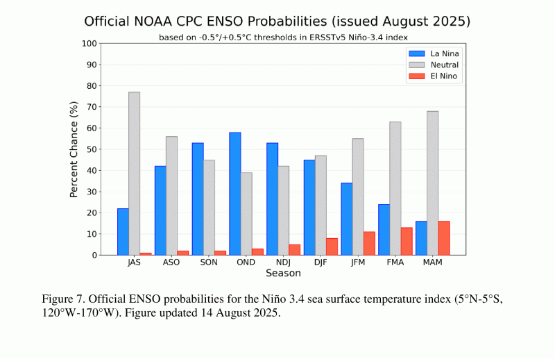
The CPC is still expecting a short-duration La Niña this fall, with the highest probability from October through December. La Niña typically means fronts push further north as the cold fronts move from west to east across the U.S. and miss the Gulf Coastal areas. So, we have mixed signals between this ENSO forecast and the information in the Climate Outlook maps.
During the past month, ENSO-neutral continued. Equatorial sea surface temperatures (SSTs) are near-to-below average across most of the Pacific Ocean. ENSO-neutral is most likely through the late Northern Hemisphere summer 2025 (56% chance in August-October). Thereafter, a brief period of La Niña conditions is favored in the fall and early winter 2025-26 before reverting to ENSO-neutral. Climate Prediction Center – September 2, 2025
–
What does this mean for Panhandle Farmers and Ranchers?
The CPC is expecting higher than average rainfall in September, but if the switch is made from ENSO Neutral to La Niña in the next few months, we can expect a drier than normal harvest season. While dry weather during harvest season is not necessarily bad news, it could mean that planting winter cover crops and cool-season forages could be delayed because of low soil moisture. It really depends on how much moisture we get in September and early October. When you look at all of the different reports, we get mixed signals about what lays ahead. The La Niña forecast could change somewhat next week, when the new monthly outlook is released, but I am not expecting that. The CPC has been consistent all summer predicting a weak La Niña to close out 2025. For much of the Panhandle, the 2025 growing season has been better than the previous two years, but has still not reached historic average for rainfall. Based on all of the information I have read, I am not expecting a big change. Unless tropical moisture pushes through the region, I am expecting rainfall to stay below normal. Even the Jay area, that had so much rainfall in May and June, has been drying out the past two months. If La Niña takes over later this fall, we can expect direr soils for planting cool-season crops. Check back next month to see if the CPC changes their predictions for the months ahead.

demayo@ufl.edu - 850-482-9620
Follow me on Twitter
@UFCowman
- 2025 Weather Summary and 2026 1st Quarter Outlook - January 16, 2026
- 2025 Average Farmland Rental Rates, Lease Agreements, and Worker Wages Summary - January 16, 2026
- Friday Feature:1954 How to Dial Your Phone - January 16, 2026