
 Rainfall
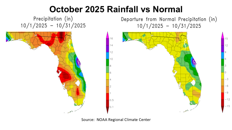
October is generally one of the direst months of the year, but this year it just added to an already dry fall. The two maps above compare 2025 October rainfall to normal. The map to the left shows the estimated rainfall for the state ranging from 6-8″ green, 4-6″ yellow, gold 2-4″, orange 1-2″ and red 0.5-1″. The map to the right shows that almost all of North Florida was below historic average in October.
–
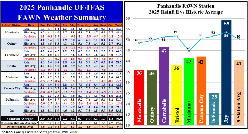
The eight Florida Automated Weather Network (FAWN) stations provided more precise rainfall data for the Panhandle. The wettest location was in Jay where 3″ fell, which was just -0.5″ below normal. Bristol was the driest location with only 1″ in October, -1.9″ below historic average. The average for all eight stations was 1.8″, -1.2″ below normal.
The average of all eight FAWN stations from January through October was 40.6″, which was -9.7″ below normal. The FAWN station at Jay was the only one that was above average through 10 months with 59.3″, 5.8″ above average. Contrast that total to only 25.1″ recorded at the DeFuniak Springs FAWN station, that was -26.6″ below average thus far. Interestingly, those two stations are only 74 miles apart.
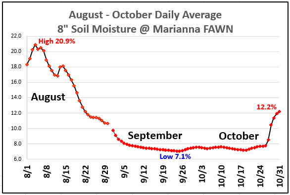
You can see in the chart above how the -8″ soil moisturechanged at the Marianna station from early August through the end of October 2025. Certainly the 2″ of rain at the end of October were welcome in Marianna, but it was too little & too late for peanuts, pastures, and hay fields, but maybe it will provide a little boost to the cotton crop or at least knock the dust down as they pick the crop.
–
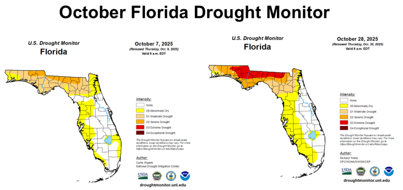
As you might expect, the lack of rainfall in October only made the drought situation worse across much of the Panhandle. The map to the left shows that at the start of the month North Florida was primarily in Moderate (Tan D1) or Severe Drought (Gold D2) categories. By month’s end, the counties on the Northern Border of Florida were in the Extreme Drought (Red D3) or Severe Drought (Gold D2) categories.
This transition from Severe to Extreme Drought (D3) did trigger disaster payments for livestock producers through the FSA Livestock Forage Disaster Program (LFP), so ranchers in the Extreme Drought (D3) counties as of the October 14th Drought Monitor (Holmes, Washington, Jackson, Gadsden, Leon, Jefferson, and Madison) should visit their local Farm Service Agency (FSA) offices to sign up for this program. In 2025, producers that qualify for the LFP will receive $41.40 per adult cow or bull, $31.50/head for cattle over 500 lbs., or $20.70/head for grazing cattle under 500 lbs. (nursing calves are not eligible) to help cover the added feed costs in this drought period.
–
 Temperatures
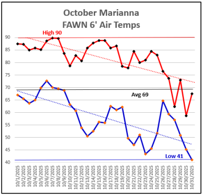
The month of October started pretty warm with a high of 90° on October 7th and 8th. The trend lines for both the high and low temperatures in the chart to the right shows the sharp decline down to the cool Halloween low of 41°. The average temperature in October was 69°, at the Marianna FAWN Station.
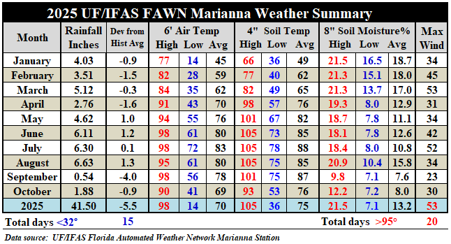
The chart below shows the summary for the monthly weather data from the Marianna FAWN Station from January through October 2025. In this chart you can see that, compared to September, the average air temperature dropped nine degrees in October, from 78° to 69°. The average soil temperature decline was similar, dropping from 87° in September to 76° in October. For the year thus far, there have been 20 days with a 6′ air temperature over 95°, but none of those occurred in October.
 –
–
 Winter Climate Outlook
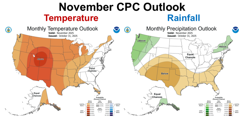
The Climate Predication Center (CPC) is expecting La Niña to impact the Southeast in November. While they made no prediction for the temperatures, the CPC is expecting below average rainfall this month.
–
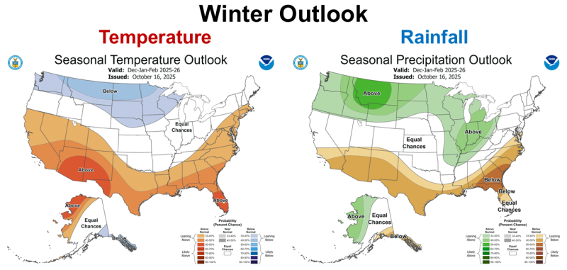
The CPC is also expecting the winter months to be drier than normal but also predict warmer than average temperatures. This does not mean there won’t be cold snaps, but overall the CPC is expecting a La Niña type winter that is warmer and drier than normal.
–
La Niña Advisory
The Climate Predication Center is expecting a weak La Niña to affect weather patterns through the winter months into early 2026. ENSO neutral is expected to return in the spring of 2026.
La Niña continued over the past month, as indicated by the strengthening of below-average sea surface temperatures (SSTs) across the central and eastern equatorial Pacific Ocean. …The atmosphere continued to reflect La Niña, with low-level easterly wind anomalies and upper-level westerly wind anomalies observed across most of the equatorial Pacific Ocean…Collectively, the coupled ocean-atmosphere system reflected La Niña. The IRI multi-model predictions favor La Niña to continue through December-February (DJF) 2025-26. While also considering predictions from the North American Multi-Model Ensemble, the ENSO team believes uncertainty for the DJF season is high with La Niña (51% chance) slightly favored over ENSO-neutral (48% chance). La Niña is expected to remain weak …A weak La Niña would be less likely to result in conventional winter impacts, though predictable signals could still influence the forecast guidance. In summary, La Niña is favored to continue into the Northern Hemisphere winter, with a transition to ENSO-neutral most likely in January-March 2026 (61% chance). Climate Prediction Center, November 13, 2025
–
What does this mean for Panhandle farmers and ranchers?
La Niña winters are something farmers in the Panhandle have a lot of recent experience with unfortunately. The current predication is that this year’s version of La Niña will be weak, so maybe we will get enough rain to break the current drought cycle. This spring, the ENSO cycle is expected to transition back to Neutral. Hopefully that will allow more typical frontal rainfall to replenish our dry soils before the next growing season begins. Winter grazing and cover crops may continue their slow growth for the next four months. I am concerned also about the current wither hay supply. Most farms had to start feeding hay at least a month earlier than normal, and our hay fields had greatly reduced yields from fall cuttings. The current forecast is not encouraging for cool-season crop growth over the next few months. If you are not sure if you have enough hay to make it through the winter, you may want to see what you can find available to purchase now, as inventories of hay for sale may get really low in February and March. Dr. Nico Di Lorenzo shared an article recently worth reading if you have not already called, Stretching Hay Reserves. The cold fronts will get stronger in the month’s ahead, so hopefully our cool-season crops will get more rain and start developing a little faster as we move into the winter months.

demayo@ufl.edu - 850-482-9620
Follow me on Twitter
@UFCowman
- 2025 Weather Summary and 2026 1st Quarter Outlook - January 16, 2026
- 2025 Average Farmland Rental Rates, Lease Agreements, and Worker Wages Summary - January 16, 2026
- Friday Feature:1954 How to Dial Your Phone - January 16, 2026