
Rainfall
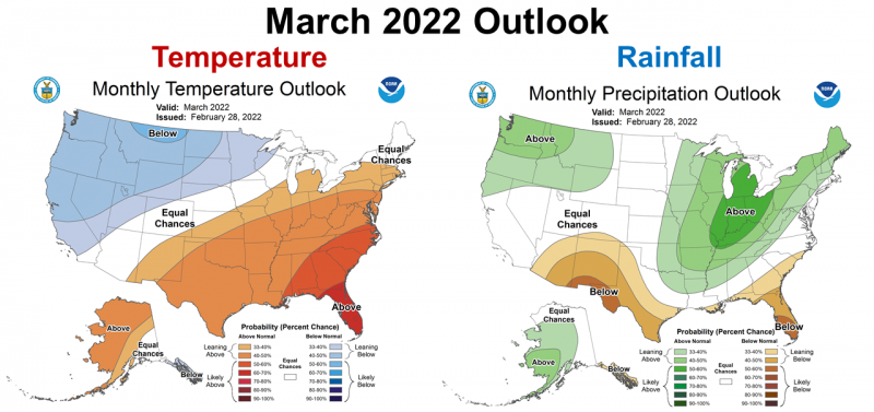 If you read Winter 2021-22 Weather Summary and Spring 2022 Drought Outlook, you know that the Climate Prediction Center (CPC) was expecting warm and dry conditions in March. Looking at the March CPC outlook (right) you can see their prediction. They were expecting a repeat of February. This forecast was primarily based on a strengthened La Niña in February. Thankfully their predictions were not correct for much of the Panhandle, but not all of it.
–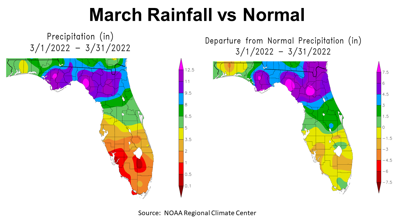
In the map to the left above you can see that the four western counties (Escambia, Santa Rosa, Okaloosa, and Walton) had lower rainfall totals in March as depicted by the yellow 3.5-5″ zone, and the light green 5-6.5″ zones. By contrast, there were areas of Calhoun, Gulf, Bay, and Liberty counties that received over 11″ in March (purple, fuchsia, & hot pink). Clearly the rainfall in March was not uniform across the Panhandle. The map to the right compares these totals to historic average for March. Areas of this map shaded tan or yellow were below average, while areas in green and blue were above average. The areas in purple, fuchsia and hot pink were well above average. So there were counties that were drier than normal, but others east of Choctawhatchee River saw trains of frontal rainfall roll through. This was good news for Forest Service Firefighters that welcomed heavy rains to get wildfires under control.
–
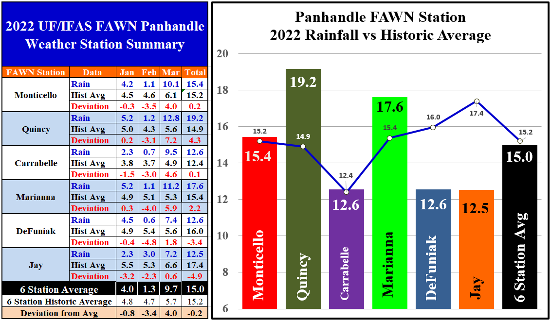
The six UF/IFAS Florida Automated Weather Network (FAWN) stations in the Panhandle document the disparity of March Rainfall. The Quincy station recorded 12.8″ in March, which was 5.6″ above normal. The Marianna station recorded 11.2″, 5.3″ above average. The FAWN Stations in Jay and DeFuniak recorded 7.2″ and 7.4″. All six stations were above normal for March, with an average of 9.7″, a total 4″ above normal. The Marianna FAWN station recorded rainfall on 10 of the 31 days in the month.
Through the first quarter of 2022, the six station average was 15″, -0.2″ below normal. So, March rainfall really helped bolster subsoil moisture. The driest location was in Jay with only 12.5″ from January through March. The FAWN stations at DeFuniak and Carrabelle have recorded 12.6″ thus far. Through three months, both the Jay and DeFuniak stations were -4.9″ and -3.4″ below average respectively. Because of the abundant March rainfall in Quincy, that station has now recorded 4.3″ more than normal through the first quarter of the year.
–
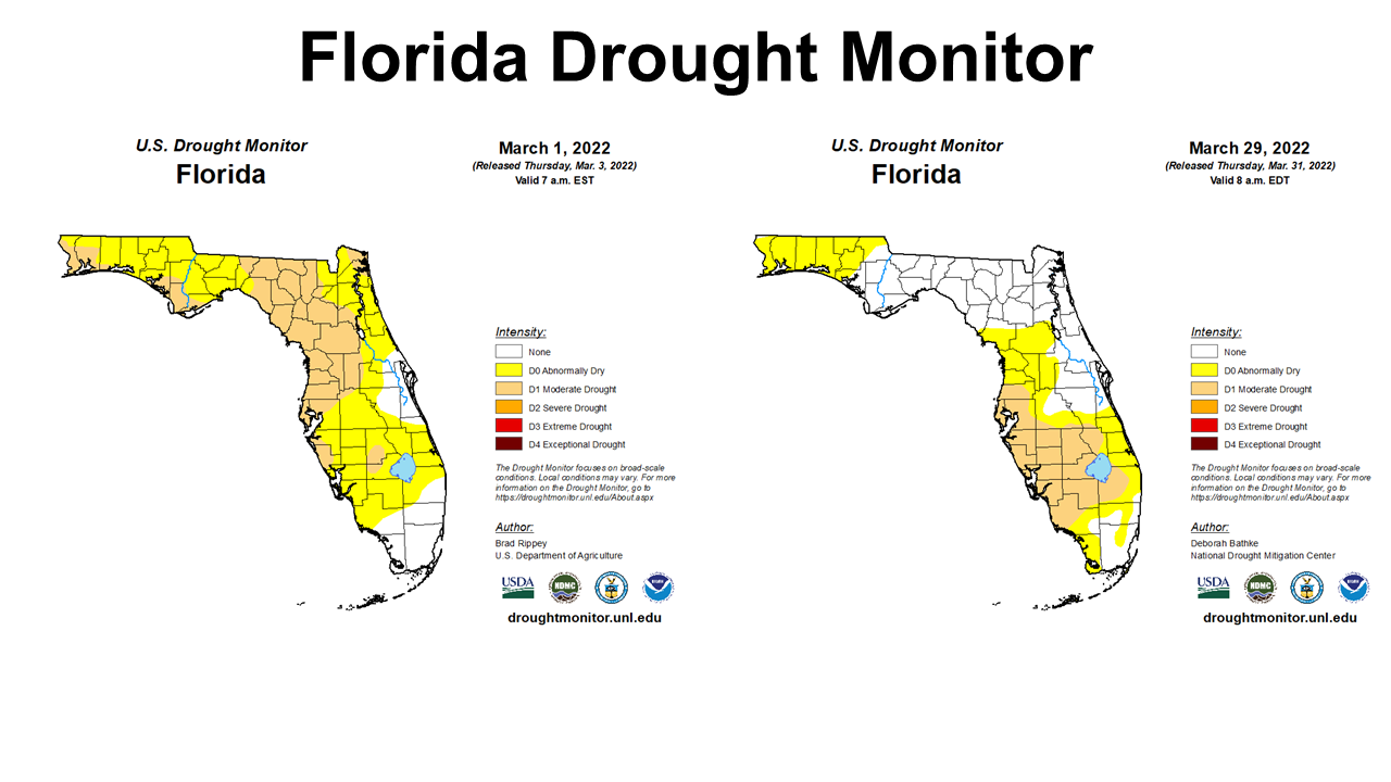
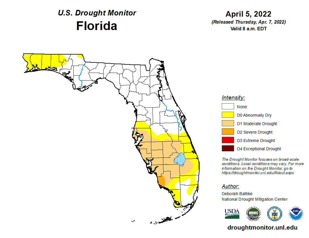 As you would expect, we also saw significant improvement in the Drought Monitor as we moved through March, but the Western portion of the Panhandle was still abnormally dry at month’s end. The rains this past weekend also helped reduce the drought zones in the Panhandle (Right).
–
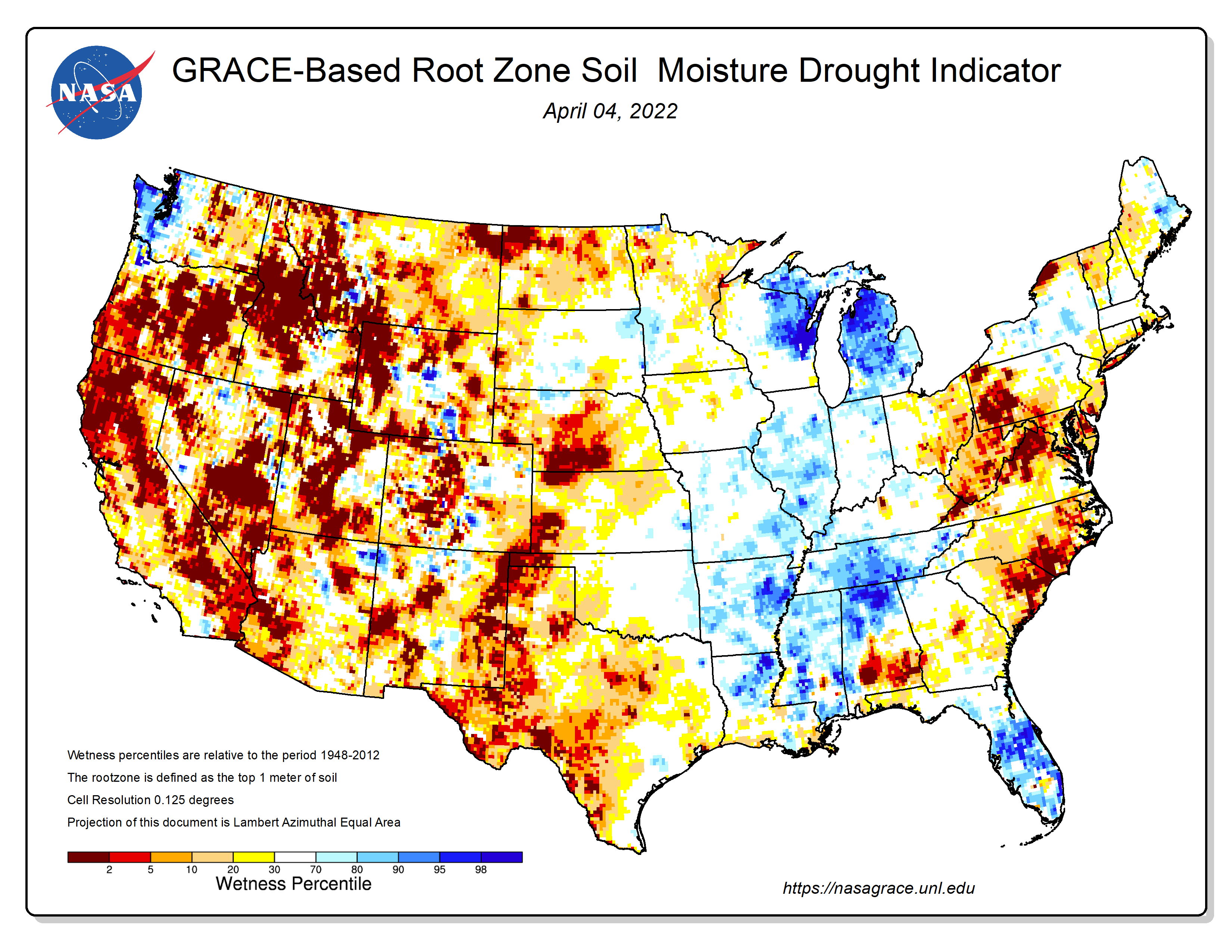
The NASA Soil Moisture Map from April 4, shows the disparity in moisture across the Southeast. Even though the same fronts have passed through the whole Panhandle, there has been much less rainfall received west of the Choctawhatchee River.
–
Temperatures
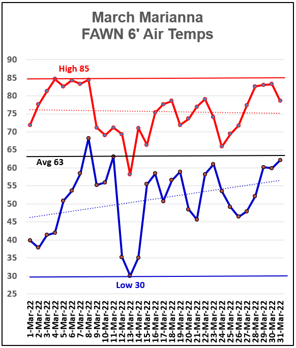
March air temperatures in Marianna made some dramatic swings through the month of March. The high of 85° was on the afternoon of March 4. The low of 30° was the morning of March 13. The average 6′ air temperature was 63°.
–
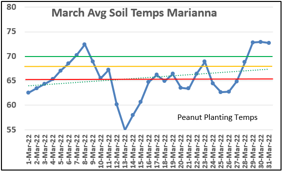
Soils warmed up at the end of March enough for good peanut germination above 70°. The average soil temperatures fluctuate this time of year, so it is real important to follow this trend in April to get plants off to a fast start. Soil temperature of 70° F for four days is recommended for planting peanut with 68° F the minimum. The weather will cool soils off this coming weekend, but the trend shown in March was that average soil temperatures rose into the optima range.
–
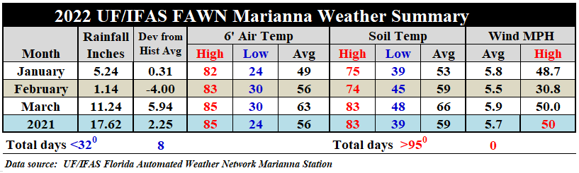
Looking at the summary of weather data from the Marianna FAWN Station through the first quarter of 2022, you can see that the average air temperature rose 7°, from 56° in February to 63° in March. The average soil temperature rose 5°, from 59° in February to 66° in March. According to NOAA, Jackson County’s average for March 2022 was 62.6°, which was 2.7° warmer than the 1900-2000 historic average. Through the first quarter the average air temperature was 55.9°, which was 1.1° warmer than the previous century average.
–
Planting Season Outlook
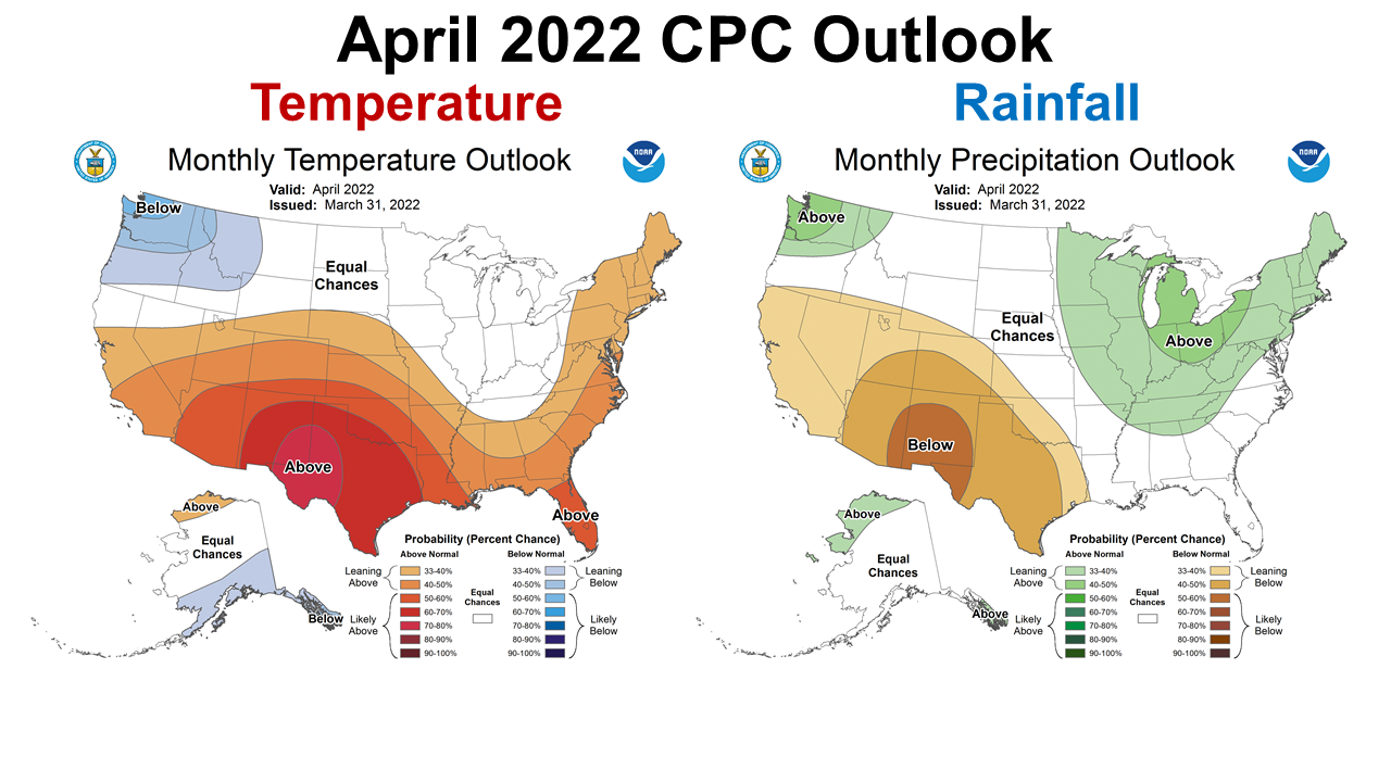
After such a depressing long range forecast in last month’s weather review, I am happy to share that while the Climate Prediction Center (CPC) is predicting the warmer than average trend to continue, the precipitation outlook for April is neutral. For the entire Southeast we have equal chances of above average, normal, or below average rainfall. This is the first time in months that the CPC has not been expecting drier than normal conditions for the region. Normal April rainfall would be alright.
–
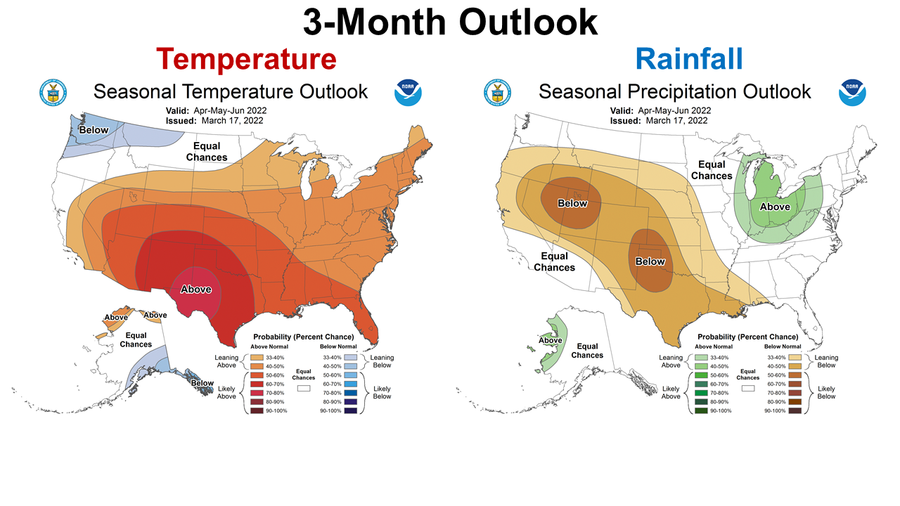
In the three-month outlook for April through June, our typical peanut and cotton planting season, the CPC expects warmer than normal temperatures. They do expect the Western Panhandle to remain dryer than the rest of Florida, but are much less confident of this forecast. Once again, more normal would be OK.
–
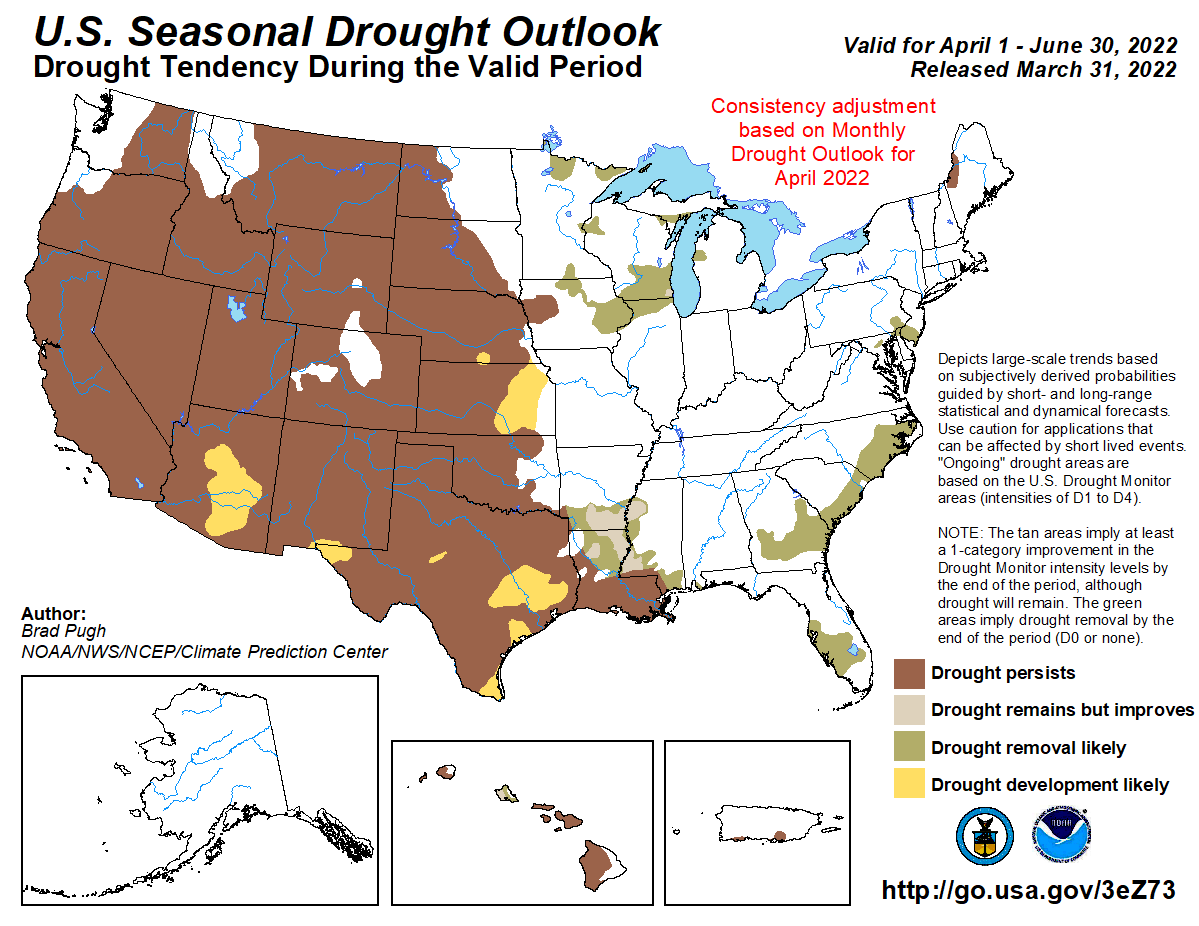
The April through June Seasonal Drought Outlook shows that the CPC expects all of Florida to see significant drought improvement through the next quarter of 2022. Unfortunately their drought forecast for the western half of the U.S. is pretty gloomy. Clearly this continued drought will affect both crop and livestock production in the Western and Midwestern States.
–
La Niña Advisory
The CPC is still thinking that the La Niña will carry through the spring. It is still uncertain if we will return to normal in the summer or just continue with La Niña all the way through next winter. This time of year the ENSO forecasts are always more unpredictable.
La Niña is present. Equatorial sea surface temperatures are below average across the east–central and eastern Pacific Ocean. The tropical Pacific atmosphere is consistent with La Niña.
For the summer and beyond, there is large uncertainty in the state of ENSO; however forecasters lean toward negative values even if the index does not reach La Niña thresholds. La Niña is favored to continue into the Northern Hemisphere summer (53% chance during June–August 2022), with a 40–50% chance of La Niña or ENSO–neutral thereafter. Climate Prediction Center
–
What does this mean for Panhandle Farmers and Ranchers?
The rainfall in March was a blessing for much of the Panhandle, but it was not at all uniform. There were areas that dealt with flooding from too much all at once, and others that got glanced over The Western Panhandle counties are still in the drought monitor, while areas east of the Apalachicola have been removed. After last month’s depressing review of February shortfalls and drier than normal forecasts, this months report is more positive for Florida. The threat of the La Niña influence with warmer and drier than normal conditions has not gone away, but March and early April rainfall have eased the mild drought in the eastern half of the Panhandle. The western counties have not been so fortunate. I still think planting with moisture will be essential for whatever crop you plan to plant. The soil moisture has improved, but we know it can quickly disappear in May. Soils are gradually warming up, so I expect once fields are dry enough, planting will be begin in full force over the coming weeks. I am more hopeful there will be a better start to the growing season. Pastures have greened up and have responded well to rainfall. I am happy the forecasters were wrong about March and possibly April, but I don’t think we are out of the danger of drought conditions yet. We will see what April showers bring, as well as the updated La Niña advisory next week. May is normally one of driest months, so there could challenges lurking. But for now, we have a more positive outlook, so lets hold onto that as we move through April.

demayo@ufl.edu - 850-482-9620
Follow me on Twitter
@UFCowman
- Northwest Florida Beef Cattle Conference & Trade Show – February 11 - December 19, 2025
- Friday Feature:The Sears Catalog –How Rural America Shopped before the Internet - December 19, 2025
- November 2025 Weather Summary & Winter Outlook - December 5, 2025