
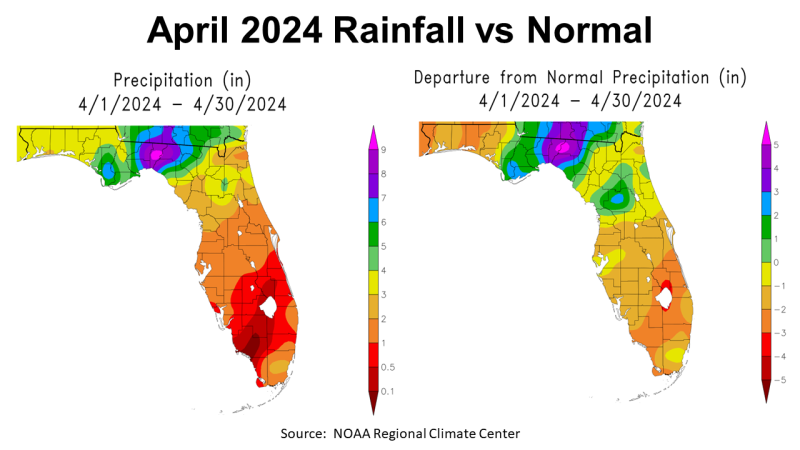
Rainfall
April was another drier than average month for the Western Panhandle Counties, but was really wet east of the Apalachicola River. This has been an ongoing trend from last year, where rainfall is very uneven in the Panhandle The map to the left above, shows the estimated rainfall based on NOAA data. The areas in yellow received 3-4″, in light green 4-5″, dark green, 5-6″, blue 6-7″, and in purple and pink over 7″. The map to the right above shows how April 2024 compared to historic average. The Central Time Zone counties were all below average, while those in he Eastern Time Zone ranged from 1-5″ or more above average.
–
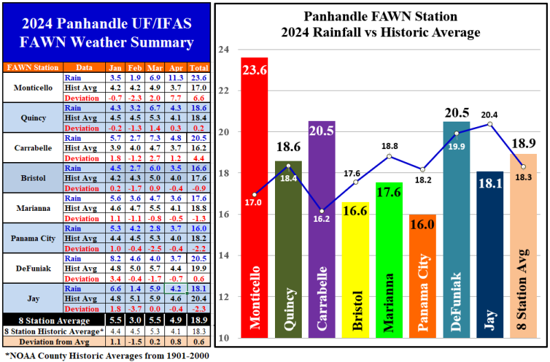
The Florida Automated Weather Network (FAWN) stations provide more precise data for the eight locations in the Panhandle. The station at Monticello recorded 11.3″ in April, which was 7.7″ above normal for Jefferson County. Contrast that with the 3.5″ that was recorded in Bristol, which was -0.4″ below average. The average for all eight stations in April was 4.9″, which was 0.8″ above normal.
From January through April, the eight station average was 18.9″, which was 0.6″ higher than normal. The wettest location by far was Monticello with a whopping 23.6″, which is already 6.6″ above historic average. Panama City was the driest location through the first third of 2024, with only 16″, -2.2″ below average.
–
 Temperatures
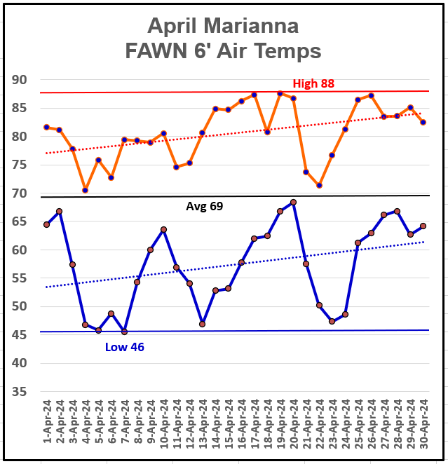
A general warm up occurred in April 2024, but looking at the trend lines above you can see the morning lows warmed faster than daytime highs. The April high temperature was 88°, on April 19th, with a low of 46° on April 5th and 7th. The average air temperature in April was 69°.
–
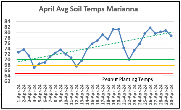
The average soil temperature rose steadily in April 2024. The three colored lines represent the minimum (red), adequate (yellow), and optimum (green) temperatures for peanut seed germination. The goal is to have at least three days above 70° (green) after planting for fast seed germination. You can see in April the average soil temperature remained 70° or above after April 13th.
–
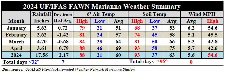 The weather summary from the Marianna FAWN Station shows the weather trends over the past four months. The average April air temperature rose 5°, from 64° in March to 69° in April. The average soil temperature rose 9°, from 66° in March to 75° in April. For the fourth month in a row, there were thunderstorms with maximum winds over 40 mph recorded.
–
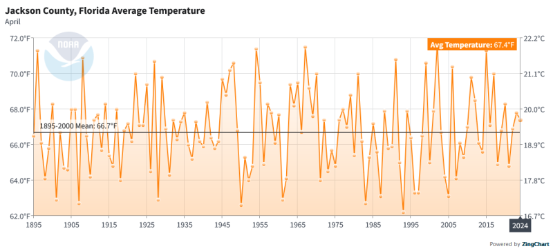 The NOAA April 2024 average air temperature was 67.4°, as compared to the previous century of weather data, shows that Jackson County was only slightly warmer than the historic average of 66.7°.
–
 Summer Climate Outlook
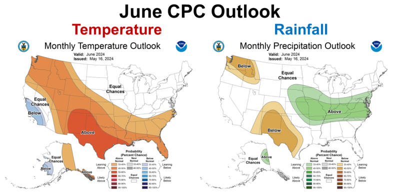
According to the Climate Prediction Center (CPC) June is expected to be warmer than average, but there is no prediction for precipitation, so near average is expected. June is typically one of the wetter months of the year in the Panhandle, so normal rainfall would be positive for crop and pasture growth.
–
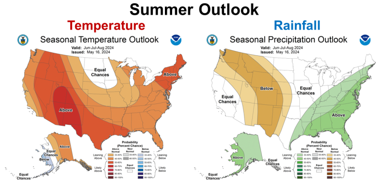
The longer-term three month outlook shows that the CPC is expecting a hot but wet summer. So while June is not expected to be wetter than normal, July and August are expected to be above average. This too seems positive for crop and pasture growth as long as we don’t get too wet. In the last few years our rainfall seems to be feast or famine, so let’s hope this forecast means regular but not excessive rainfall.
–
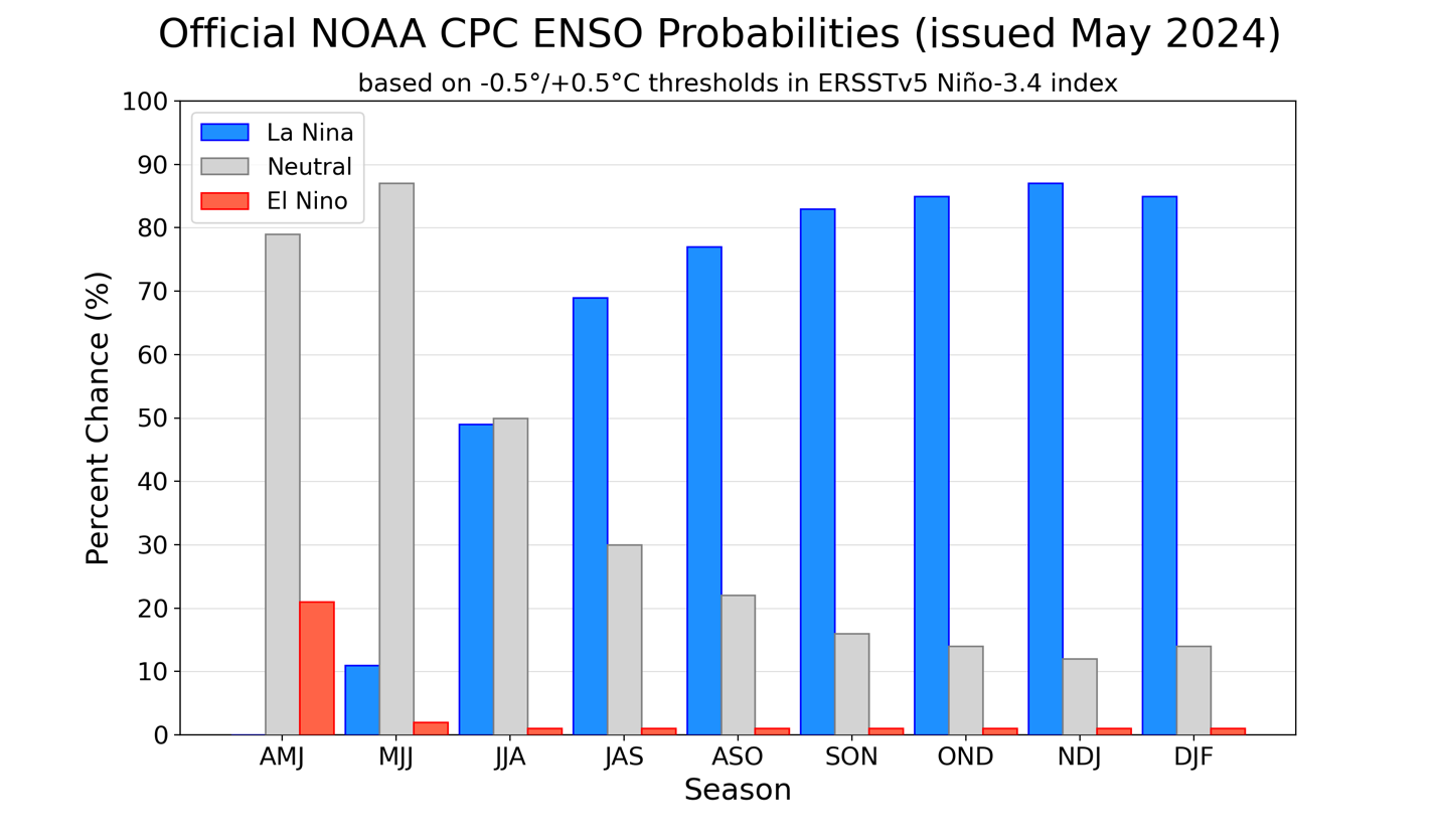
Official ENSO probabilities for the Niño 3.4 sea surface temperature index (5°N-5°S, 120°W-170°W). Figure updated 9 May 2024.
El Niño Advisory / La Niña Watch
El Niño is not dead but is fading fast. The transition to Neutral is not far off. The real concern is the return of La Niña not too long after the transition to Neutral.
During April 2024, below-average equatorial sea surface temperatures (SSTs) emerged in small regions of the eastern Pacific Ocean. However, above-average SSTs prevailed across the rest of the equatorial Pacific. The latest weekly Niño index values remained between +0.5°C and +0.8°C in all regions, except for Niño-3 which was +0.3°C. Below-average subsurface temperatures held steady during the month (area-averaged index), with negative anomalies extending from the Date Line to the eastern Pacific Ocean. Low-level wind anomalies were easterly over the western equatorial Pacific, while upper-level winds were near average. Convection was near average overall across the equatorial Pacific Ocean and Indonesia. Collectively, the coupled ocean-atmosphere system reflected the continued weakening of El Niño and transition toward ENSO-neutral.
The most recent IRI plume favors an imminent transition to ENSO-neutral, with La Niña developing during July-September 2024 and then persisting through the Northern Hemisphere winter. The forecast team continues to favor the dynamical model guidance, which suggests La Niña could form as early as June-August 2024, with higher confidence of La Niña during the following seasons. La Niña generally tends to follow strong El Niño events, which also provides added confidence in the model guidance favoring La Niña. In summary, a transition from El Niño to ENSO-neutral is likely in the next month. La Niña may develop in June-August (49% chance) or July-September (69% chance). Climate Prediction Center
–
What does this mean for Florida Panhandle farmers and ranchers?
The high pressure system blocking rainfall across the Southeast has been pushed out of the area. A drier than normal April for the Western Panhandle should improve in the coming months. Although none of the region fell into the Drought Monitor categories in April, soils were drying out quickly. The current forecast of a transition to ENSO Neutral should mean normal summer rains in the region, but what is normal of late? Crops and pastures should progress well with warm temperatures and average to above average rainfall. Based on the La Niña forecast, we can expect drier than normal conditions late in the growing season. Dry weather at harvest time can be positive for final warm-season crop yields, but may hurt cool-season crop planting and seed germination. After last year, average or above average yields would be a blessing. While 2024 has not been ideal yet, it may be more normal in the coming months, if the CPC’s outlook forecasts are accurate. Hurricane Season starts next month, and we all know that tropical storms can create serious challenges, but as of today, the climate outlook is positive for agriculture in the Florida Panhandle for the summer. We will see how this changes over the months ahead.

demayo@ufl.edu - 850-482-9620
Follow me on Twitter
@UFCowman
- 2025 Weather Summary and 2026 1st Quarter Outlook - January 16, 2026
- 2025 Average Farmland Rental Rates, Lease Agreements, and Worker Wages Summary - January 16, 2026
- Friday Feature:1954 How to Dial Your Phone - January 16, 2026