
 Rainfall
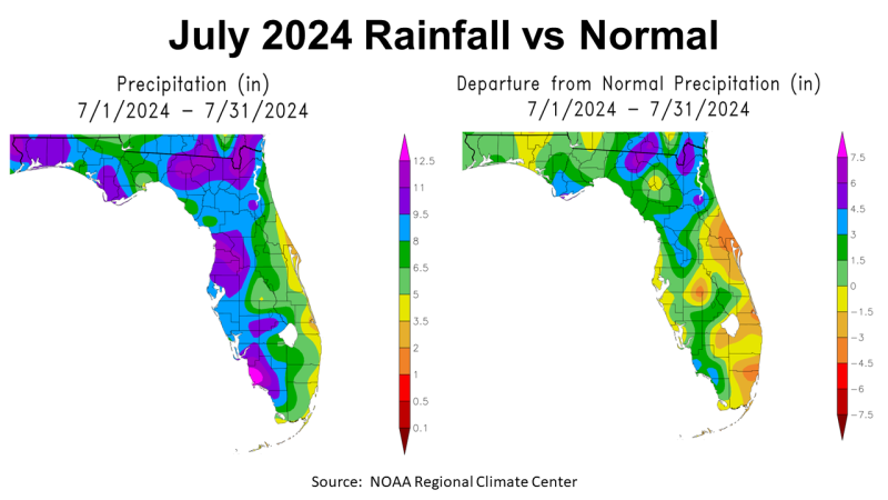
July 2024 was a mix of drought ending rainfall with high temperatures in between thunderstorms in the Florida Panhandle. The map above to the left showed that estimated July rainfall in the Panhandle ranged from 5-6.5″ (light green), 6.5-8″(green), 8-9.5″ (blue), 9.5-11″ (purple), to over 11″+ in western Escambia County. The map to the right shows how the rain in July 24 compared to historic average. There was an area in Holmes, and Walton Counties, and the western edges of Jackson, Washington, and Bay Counties that were slightly below average. Most of the Panhandle was 0-1.5″ above average (light green), or 1.5-3″ above average (green) in July.
–
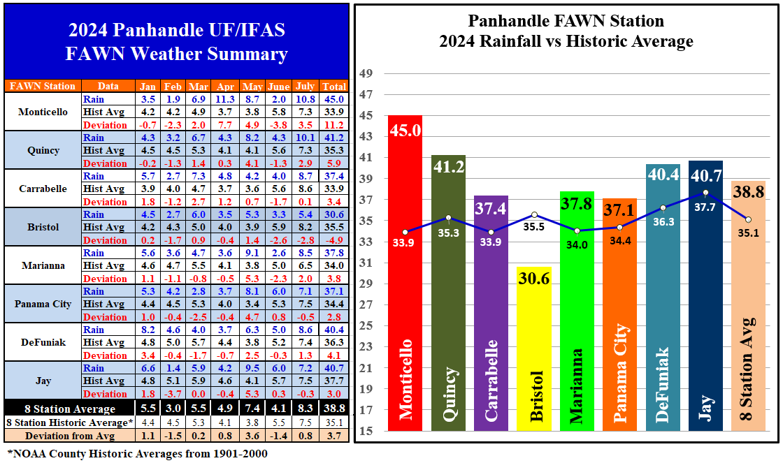
The eight Florida Automated Weather Network (FAWN) stations data shows more specific rainfall summaries from July 2024. After receiving only 2″ in June, the Monticello FAWN Station recorded 10.8″ in July, which was 3.5″ above historic average for Jefferson County. Contrast that with the 5.4″ collected in Liberty County at the Bristol FAWN station, which was -2,8″ below the county average. The average of all eight stations in July was 8.3″, just 0.8″ above normal.
Through the first seven months of 2024, only the FAWN Station at Bristol was well below historic average, with only 30.6″ recorded (-4.9″ below average) as compared to the 35.5″ historic county average. Compare that with the 45″ that has been recorded so far in Monticello, as these two counties are not that far apart. The station in Monticello has received 11.2″ more than historic average in Jefferson County. This shows that summer thunderstorms are not at all uniform. The average for all eight FAWN Stations in the Panhandle was 38.8″ thus far in 2024, which was 3.7″ higher than normal.
–
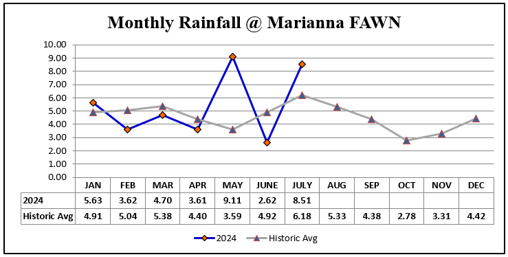
Averages don’t tell the whole story though, as can be seen in the chart above that shows month by month rainfall data recorded at the Marianna FAWN Station in comparison with historic average. This station has recorded 37.8″, which was 3.8″ above average for the year thus far. That sounds like a good year, but all of that extra rainfall fell in May and July. While the extra rainfall has certainly benefited crops and pastures, these plants suffered through a hot and dry June. The lost plant growth and reduced livestock weight gains will impact final yields and income from the June flash-drought (dry and really hot).
–
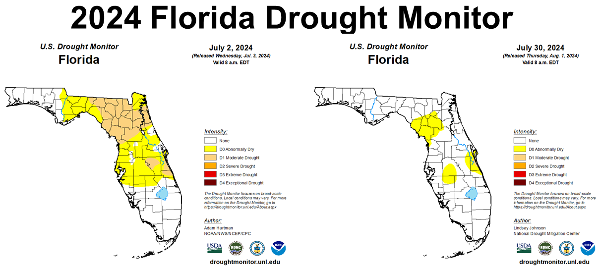
Thankfully, the extra rainfall in July did end the drought conditions across much of North Florida, which started the month in the Abnormally Dry D0 (yellow), or Moderate Drought D1 (tan) categories. Florida only had a few counties that remained abnormally dry at month’s end. I am pretty sure Hurricane Debby has resolved those issues in early August.
–
Temperatures
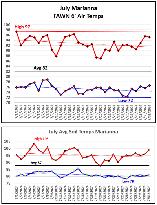
The afternoon storms did offer some temporary cooling relief in July, but it was still a hot and steamy month. The air temperature chart above shows that the high of 97° came on July 1st, with a low of 72° on the morning of July 26th. There were 10 days in July with afternoon high temperatures over 95°, but no triple digit highs this month. The low temperature has remained in the 70s every morning since June 22nd. The average six-foot air temperature was 82° in July. The trend lines show that both the daily highs and lows were trending somewhat cooler from the beginning to the end of July.
The lower chart above shows the soil temperatures. I found it very interesting that the high of 103° was on July 5th (not July 1st), which was a day with an air temperature high of 95°. The low of 78° was on July 26th, which was the same day that the air temperature dropped to 72°. The average soil temperature was 87° in July.
–
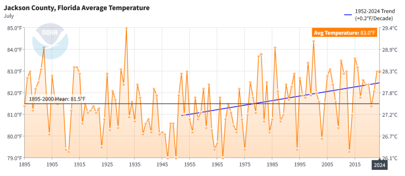 According to NOAA, the average air temperature in Jackson County was 83° in July 2024, which was 1.5° warmer than the historic mean. The blue trendline shows how the July average air temperature has changed since 1952 (When weather started being collected at the Marianna Research Station). While the general trend is warming, the highest July average air temperature was 85° in 1932, followed by 84.4° in the year 2000.
–
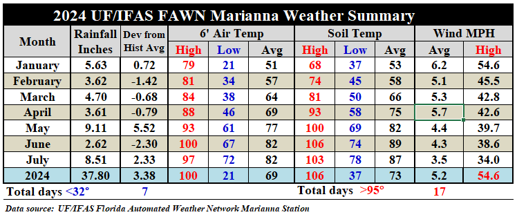
As compared to June, the average July air temperature stayed at 82°, so even though there were no triple digit highs, July was still a very hot month. The average soil temperature did drop two degrees from 89° in June to 87° in July. Not only was it hot and muggy, but there was also not a lot of air movement with an average wind speed of only 3.5 mph in July.
–
 Climate Outlook
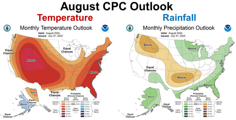
The Climate Predication Center (CPC) is expecting the hotter than normal temperatures and the above average rainfall to continue across the whole state of Florida in August. The “Dog Days of Summer” are predicted to keep going for another month.
–
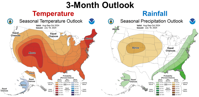
When you look at the CPC Outlook for August through October, the general trend is very similar to what is expected in August. This outlook forecast was created back on July 18th, so at this point the CDC is not expecting La Niña to affect the currnet climate. Just remember that October is typically one of the driest months of the year, so above average does not mean the same in October as it does in August. It does appear from this forecast that the CPC is not expecting drought to return to Florida for the rest of the growing season.
–
 La Niña Watch
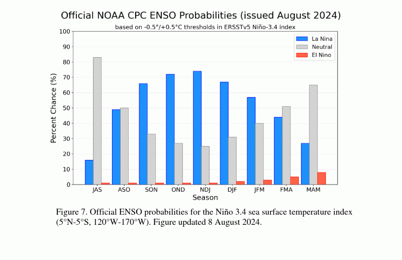
According to the CPC, we are still in the ENSO-Nuetral phase, as the Pacific waters are cooling slower than first predicted, but they are still pretty certain that La Niña is coming this fall. In thee chart above you can see that the CPC anticipates that the greatest probability for La Niña is from October through February.
ENSO-neutral continued during July 2024, with near-average sea surface temperatures (SSTs) observed across most of the equatorial Pacific Ocean…Below-average subsurface temperatures strengthened during the past month associated with the expansion of negative anomalies. Low-level wind anomalies were easterly over the east-central and eastern Pacific, and upper-level winds were westerly over the eastern Pacific. Convection was near average around Indonesia and the Date Line. Collectively, the coupled ocean-atmosphere system reflected ENSO-neutral.
The IRI plume indicates that Niño-3.4 is most likely to be below La Niña thresholds for four overlapping seasons, from September-November 2024 through December 2024 – February 2025. Based on updated guidance and recent observations, the forecast team predicts nearly equal chances for ENSO-neutral and La Niña in August-October 2024, with higher odds for La Niña in September-November. Although the rate of SST cooling has been slower than previously anticipated, below-average subsurface temperatures and low-level easterly wind anomalies remain conducive to La Niña development in the coming months. In summary, ENSO-neutral is expected to continue for the next several months, with La Niña favored to emerge during September-November (66% chance) and persist through the Northern Hemisphere winter 2024-25 (74% chance during November-January). August 8, 2024 – Climate Prediction Center
–
What does this mean for farmers and ranchers in the Florida Panhandle?
The CPC’s current one-month and three-month outlooks predict above average rainfall for all of Florida. Crops and pastures have recovered, for the most part, from the heat and rainfall deficit in June. While you can never get back lost growth and production, the outlook for the remainder of the growing season looks positive. It does appear that we can expect a warmer and drier than average fall and winter from La Niña. This could be positive for crop and hay harvest in October, but not as favorable for cool-season crops, cover crops. and forage planting. The other negative is that La Niña ENSO phases often result in increased hurricane activity. Things are looking good right now, so let’s look on the positive side. You can wait and see on fall planting decisions, but if you want the top varieties, you need to place your order within the next month with the seed companies.
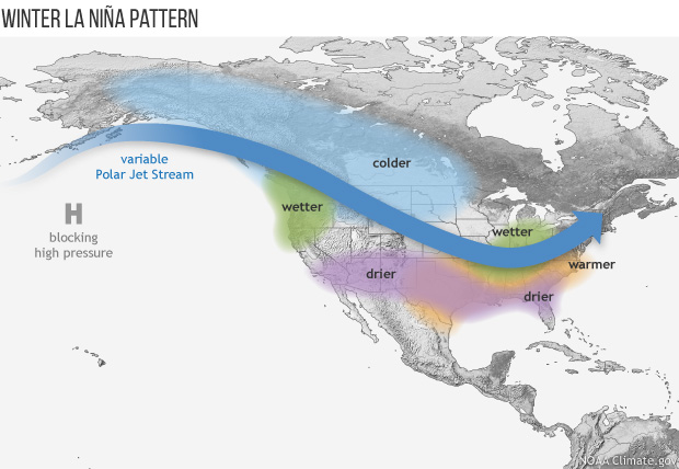
La Niña Weather Pattern Photo Credit: NOAA

demayo@ufl.edu - 850-482-9620
Follow me on Twitter
@UFCowman
- Northwest Florida Beef Cattle Conference & Trade Show – February 11 - December 19, 2025
- Friday Feature:The Sears Catalog –How Rural America Shopped before the Internet - December 19, 2025
- November 2025 Weather Summary & Winter Outlook - December 5, 2025