
Rainfall (or lack thereof)
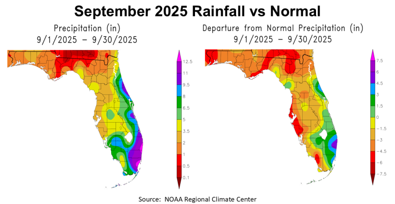
September 2025 was a harsh month in the Florida Panhandle. The maps above show the estimated rainfall in September compared with historic average for the month. While the area that had been so dry in South Florida finally got considerable rainfall, most of the Panhandle ranged from -1.5″ to -6″ below normal in September.
–
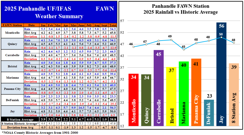
The data from the eight Florida Automated Weather Network (FAWN) stations shows more precise variation of rainfall across the Panhandle. All eight stations were below historic average in September. The wettest location was near Jay with 2.1″, -3.7″ below average. Two counties over, the driest location was DeFuniak Springs where only 0.2″ was recorded, which was -5.4″ below average. The average of all eight stations was 1″, -4.7″ below normal.
Through the first 3/4 of 2025, the average for all eight stations was 38.8″, which was -8.8″ off from the historic average. DeFuniak was by far the driest location with only 23.3″, -25.2″ below normal. The FAWN Station in Jay has recorded 56.3″, which was actually 6.3″ higher than normal. The Jay location was the only one above average through September.
–
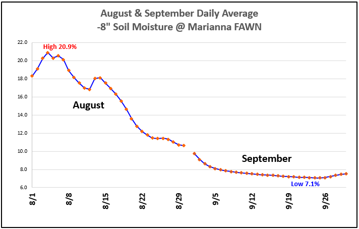
The chart above shows the change in daily average soil moisture at Marianna over the last two months. This data clearly shows why Jackson County moved into the Severe Drought Category at the end of September. Since I have just started monitoring soil moisture this year, I don’t have a historic average or normal to compare to, but the 7.1% moisture September 21-26 was the lowest yet this year, at the -8″ depth. A growing season that looked very promising in early August, fell apart after 32 days (or more in many locations) without significant rainfall.
–
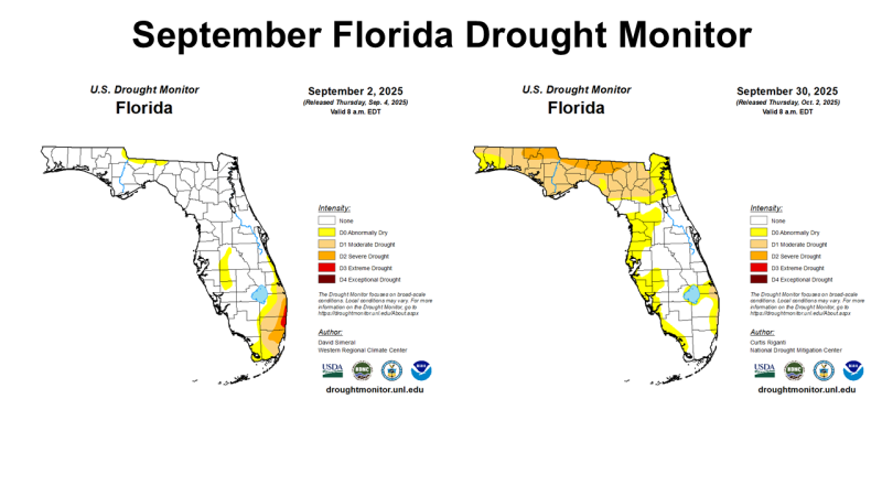
At the start of September, it was the Southeast tip of Florida that was still in Severe or Extreme Drought. By month’s end, all of North Florida was suffering from drought conditions, but South Florida was in much better shape. Florida is a long slender state, so weather patterns are distinctly different from north to south. The September 30 map (right) shows that most of North Florida was in either Moderate or Severe Drought at month’s end.
–
 Temperatures
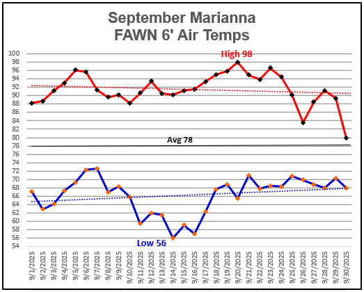
September temperatures had a huge range from a low of 56° on the morning of September 14 to a high of 98° the afternoon of September 20, less than a week apart. The average 6′ air temperature was 78°, which was 2° cooler than the 80° in August. Mainly because of some cooler weather in the middle of the month, because there were 6 days with high temperatures of >95° in September compared to just 1 in August.
For specific daily temperatures and rainfall data from the Marianna FAWN station, and monthly rainfall totals from all eight FAWN stations in the Panhandle, use the following link: January-September 2025 Jackson Co Weather Summary
–
Climate Outlook
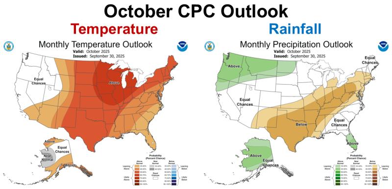
The Climate Prediction Center’s (CPC) October Outlook is expecting the warmer than average trend to continue for almost the entire U.S except for the Pacific Northwest. They provide no rainfall prediction for much of the Southeast with equal chances of above or below average in North Florida but expect South Florida to remain wetter than average like last month. October is normally the driest month of the year in North Florida, so even average rainfall likely would not erase the drought from more than a month of limited rainfall from mid-August through September.
–
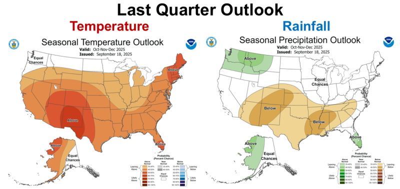
The CPC’s outlook for the final quarter of 2025 is very similar to the Outlook for October. La Niña is expected to keep most of the Southeast warmer than normal. The CPC makes no predication for rainfall in the Panhandle, but with the announcement of change to La Niña this week, I would not be surprised if below average rainfall expands to include the entire Southeast.
–
La Niña Advisory
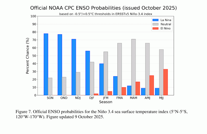
On October 9, 2025, the National Weather Service and the Climate Predication Center announced we are officially in another La Niña for the next several months. This subtle change in ocean temperatures has a significant influence on cold fronts that sweep from west to eat across the U.S. Although they are predicting this year’s La Niña to be weak, it still is not good news for overcoming current drought conditions.
La Niña conditions emerged in September 2025, as indicated by the expansion of below-average sea surface temperatures (SSTs) across the central and eastern equatorial Pacific Ocean. The latest weekly Niño-3.4 index value was -0.5°C, with other regions remaining at or between -0.1°C and -0.4°C. Negative subsurface temperature anomalies persisted, with below-average temperatures prevailing from the surface to 200m depth in the eastern half of the equatorial Pacific. Over the western and east-central equatorial Pacific, low-level wind anomalies were easterly and upper-level wind anomalies were westerly. Convection continued to be enhanced over Indonesia and was suppressed near the Date Line. The equatorial Southern Oscillation index was positive. Collectively, the coupled ocean-atmosphere system reflected La Niña conditions.
The IRI multi-model predictions favor La Niña through the Northern Hemisphere winter 2025-26. The North American Multi-Model Ensemble is also in agreement, and based on recently observed anomalies, the team favors La Niña to continue through winter. At this time, La Niña is expected to remain weak (3-month average Niño-3.4 index value at or between -0.5°C and -0.9°C). A weak La Niña would be less likely to result in conventional winter impacts, though predictable signals could still influence the forecast guidance. In summary, La Niña conditions are present and favored to persist through December 2025 – February 2026, with a transition to ENSO-neutral likely in January-March 2026 (55% chance). Climate Prediction Center, October 9, 2025
 –
–
What does this mean for Panhandle farmers and ranchers?
In early August, crops fields and pastures looked great. It was looking like we would finally have above yields this season. That was before the flash drought (high temperatures with very limited rainfall) took hold of the Panhandle. When we have highs in the mid to upper 90s without rainfall, soil moisture disappears. Over a 60-day stretch everything declined. Now we have the news that we can expect this trend to continue through February because of a weak La Niña. This does not mean there won’t be any rain, just less than normal. However, we have had so many drier than normal winters lately it is hard to remember what a normal was like. In the Florida Panhandle, winter is normally a time of water recharge for soil, ponds, lakes, and rivers. Should you plant winter grazing or cover crops this year? Yes, but you may want to be more conservative as in recent years. Make sure you plant with good soil moisture and select fields that hold moisture well. Overseeding existing dormant pastures looks even more risky than normal this year. Even so, hay will likely be in short supply come spring, because the October hay cuttings we count on annually were made in September with lower yields. If you buy your hay, you probably need to lock-in an order for the entire winter very soon. Peanut hay is certainly an option that has bailed producers out for many years, but this year vine quality may be poor once the peanuts are harvested. I would certainly advise having whatever kind of hay you have tested for quality, as the quality may not be typical this season. I wished I was sharing better news but check back next month to see if there are any changes to current predications.

demayo@ufl.edu - 850-482-9620
Follow me on Twitter
@UFCowman
- November 2025 Weather Summary & Winter Outlook - December 5, 2025
- Friday Feature: The History of Beekeeping - December 5, 2025
- Friday Feature:Malone Pecan Festival Tractorcade - November 21, 2025