
Rainfall
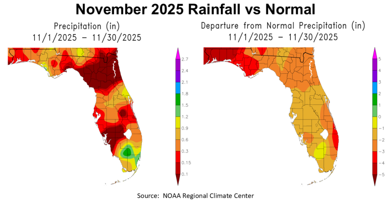
November was yet another very dry month in the Panhandle. You can see in the map to the left above that almost the entire state of Florida received less than 1.2″ (except area in green) in November. There was also a large area of Northeast Florida that had less than 0.1″ (brown). The map to the right above shows how November 2025 rainfall compared to historic average (normal). The entire Panhandle was at least -2′ below average (orange), with the western counties -4″ below average (dark red).
–
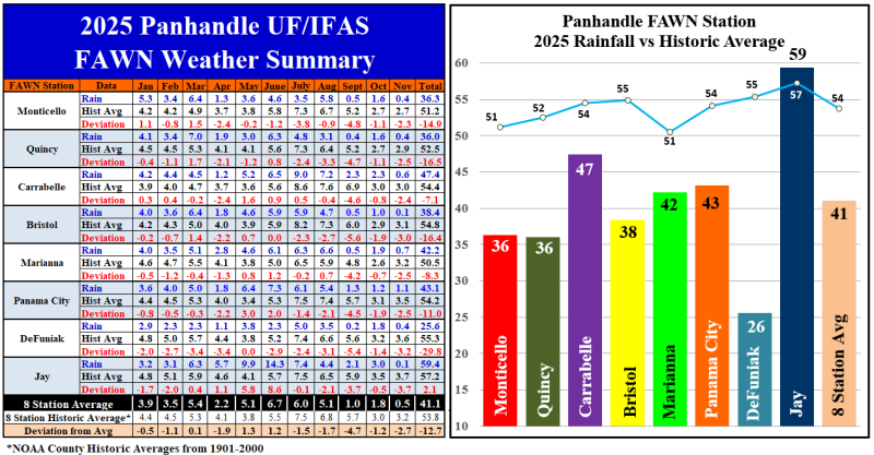
The eight Florida Automated Weather Network (FAWN) weather station data shows a more precise variation in rainfall across the Panhandle. All eight stations were below historic average for November. The driest location was Jay, with only 0.06″ (rounded to 0.1″ in chart above), which was -3.7″ below normal. The highest total was in Panama City with 1.1″, that was still -2.5″ below normal. The average for all eight stations was 0.5″, -2.7″ below normal.
Through 11 months of 2025, the average for all eight stations was 41.1″, which was -12.7″ below average. The highest total thus far was in Jay with 59.4″, which was 2.1″ above normal. The driest location was DeFuniak Springs totaling only 25.6″, -29.8″ below normal.
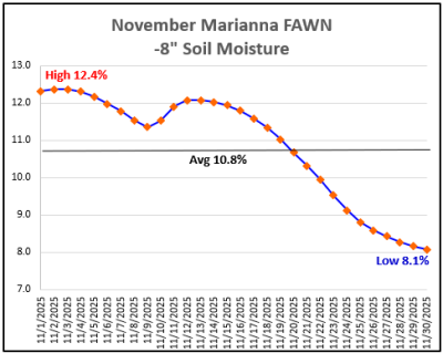 Looking at the -8″ soil moisture chart to the right from the Marianna FAWN Station, you can see that soil moisture continually dropped through November, from a high of 12.4% on November 2 and 3, to the low of 8.1% on November 30. There was a moisture boost at the end of October, but as you can see in the chart, it quickly diminished again. November makes the 7th month in 2025 with soil moisture dropping below 10% at the eight inch soil depth in Marianna.
–
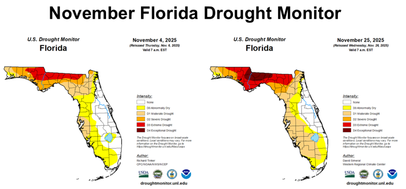
The two Drought Monitor maps above show the drought situation changes from November 4 and November 25. A bad situation got worse in November, as the zone of D3 Extreme Drought (red) expanded, and a portion of the Panhandle declined into the D4 Exceptional Drought (brown) category. Except for the East Coast, much of Florida continued to dry out in the month of November. Fortunately, rainfall the first week of December is expected to provide significant improvement to the Panhandle.
–
 Temperatures
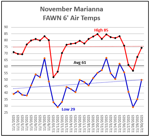
The 6′ air temperatures at Marianna remained relatively cool with a monthly average of 61° in November. The high for the month was 85 ° on November 20 and 22. There was an early freeze in 2025 with a low morning temperature of 29° on November 11 (Veteran’s Day) and again on November 28. The significance of a Veteran’s Day freeze was that pastures, already significantly depressed from extended drought, went dormant one to two weeks earlier than normal. However, most farms had already been feeding hay for several weeks due to the lack of growth in September and October.
–
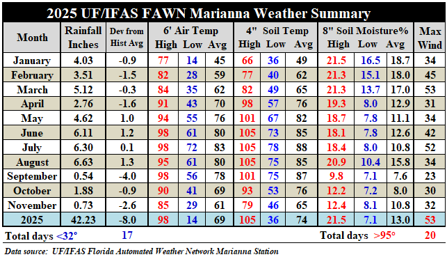
The weather summary chart above from the Marianna FAWN station shows that average air temperature dropped 8°, as compared to October, from 69° to 61° in November. The average soil temperature dropped 11° in November, from 76° in October down to 65° in November. This summary chart also shows the breakdown of high, low, and average 8″ soil moisture percentages from each month. Notice the change started in April, when soil moisture dropped below 10% in every month except for August. September was the driest never breaking above 10% soil moisture.
–
Winter Climate Outlook
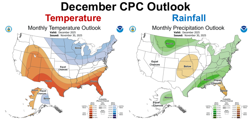
In the two U.S. Maps above, you can see the Climate Predication Center’s (CPC) expectations for temperature and rainfall in December 2025. The CPC is expecting warmer than average temperatures with equal chances for below or above average rainfall over much of the Panhandle in December. However, the CPC is expecting the majority of Florida to see below average rainfall in December.
–
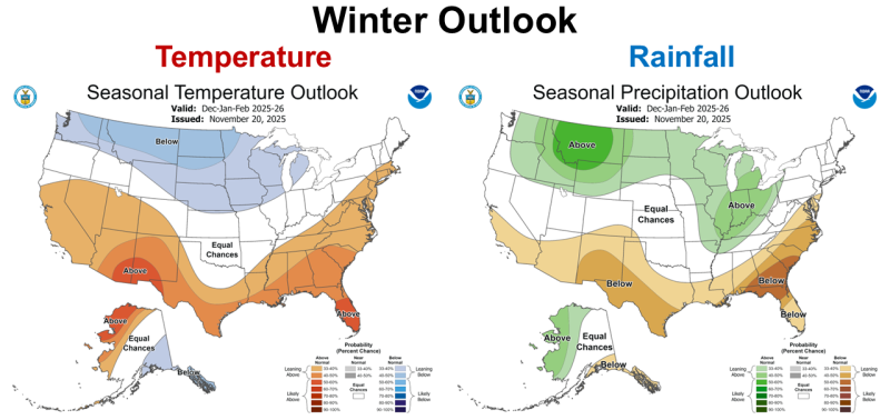
The CPC’s three-month or Winter Climate Outlook maps show a more typical forecast for a La Niña winter, strong confidence of above average temperatures and below average rainfall. These maps were created 10 days before the single month outlook, so that may explain some of the differences in the two outlook maps. While December is starting with significant rainfall in the short-term forecast, the CPC is expecting direr than normal winter through February.
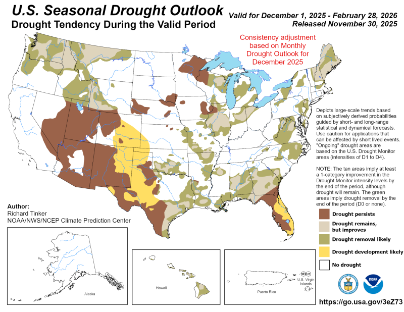
Based on the winter precipitation expectations, the map above shows how the next three months should affect the current drought situation. For much of Florida, their expectation is that the current drought conditions will persist, but in the Panhandle some improvement is expected,
–
La Niña Advisory
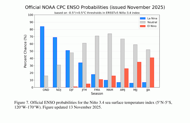
The November 13 ENSO Update included the probability chart above. The CPC continues to expect a shift back to ENSO Neutral in the first quarter of 2026. The interesting part of this chart is the increasing probability of El Niño as we move later in 2026.
La Niña continued over the past month, as indicated by the strengthening of below-average sea surface temperatures (SSTs) across the central and eastern equatorial Pacific Ocean. The latest weekly Niño indices were between -0.5°C and -0.7°C, with the exception of the easternmost Niño-1+2 index at -0.2°C…The atmosphere continued to reflect La Niña, with low-level easterly wind anomalies and upper-level westerly wind anomalies observed across most of the equatorial Pacific Ocean. Enhanced convection persisted over Indonesia and was weakly suppressed near the Date Line. Both the traditional and equatorial Southern Oscillation indices were positive. Collectively, the coupled ocean-atmosphere system reflected La Niña.
The IRI multi-model predictions favor La Niña to continue through December-February (DJF) 2025-26. While also considering predictions from the North American Multi-Model Ensemble, the ENSO team believes uncertainty for the DJF season is high with La Niña (51% chance) slightly favored over ENSO-neutral (48% chance). La Niña is expected to remain weak (3-month average Niño-3.4 index value at or between -0.5°C and -0.9°C). A weak La Niña would be less likely to result in conventional winter impacts, though predictable signals could still influence the forecast guidance. In summary, La Niña is favored to continue into the Northern Hemisphere winter, with a transition to ENSO-neutral most likely in January-March 2026 (61% chance).
–
What does this mean for Panhandle farmers and ranchers?
Not much new information with the CPC’s updated climate outlook maps or their La Niña Advisory. The climate experts remain confident that we will have a warmer and drier than average winter in the Panhandle. December rainfall may provide some level of water recharge, but drought removal is not expected this winter, except in the western most counties. In fact, a significant portion of Peninsular Florida is expected to stay in drought or move into drought in the coming months. There is hope for the 2026 growing season, however, as the weak La Niña is expected to end early in the year. With a growing possibility of El Niño later in the year, the Panhandle may be in a better situation next winter, but it is still way too early to know that yet. December rainfall in the Panhandle is historically in the 4″ range, so it is pretty likely that 2025 will end well short of normal rainfall for most of the Panhandle.
I expect the winter forages and cover crops that have been planted to continue to have reduced growth but am hopeful of a positive response to early December rainfall. Because of reduced hay yields this fall, and the need to start feeding hay much earlier this year, I also expect hay supplies to dwindle earlier than normal in the first quarter of 2026. Ranchers should carefully monitor their hay supplies. I recently created a simple record sheet to help monitor hay inventory called the Hay Inventory Tracker. Use this tool to help track your current supply and to help estimate the future hay consumption rate. If you think you might run short on hay this winter, I would encourage you to contact local suppliers soon to secure more hay before their inventories start running low in 2026. Early spring planted crops such as corn, vegetables, and melons will likely require irrigation to progress well after planting. For years I have heard farmers joke that this drought will end as soon as it starts raining regularly again. Based on our current climate expert outlooks that may not happen in the next three months. However, a new year brings new optimism, especially when we move back to ENSO Neutral.

demayo@ufl.edu - 850-482-9620
Follow me on Twitter
@UFCowman
- 2025 Weather Summary and 2026 1st Quarter Outlook - January 16, 2026
- 2025 Average Farmland Rental Rates, Lease Agreements, and Worker Wages Summary - January 16, 2026
- Friday Feature:1954 How to Dial Your Phone - January 16, 2026