
Rainfall
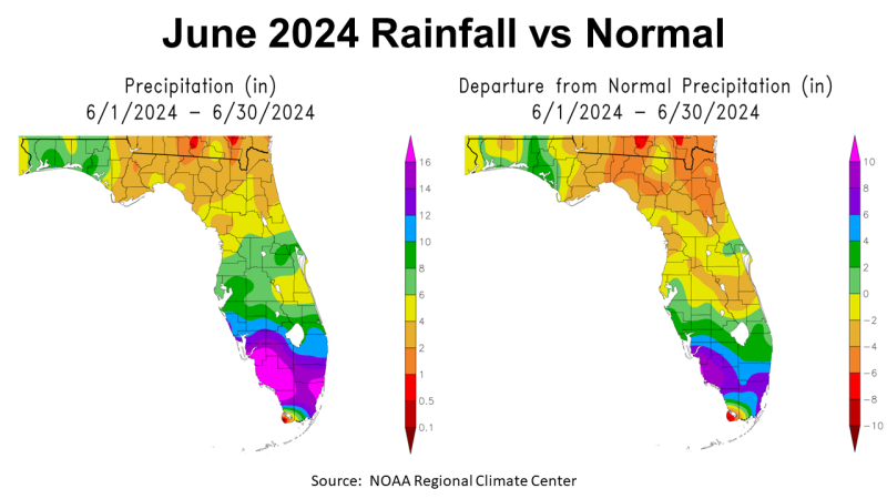
June 2024 was a mixed month for Panhandle rainfall, with high summer temperatures across the region. The map above to the left shows an estimate of total rainfall across Florida in June 2024. Areas in tan had 2-4″, yellow 4-6″. light green 6-8″, and dark green 8-10″. In South Florida, the tropical depression and summer thunderstorms dumped from 10″ to over 16″ on an area that had been very dry. The map above to the right shows the departure from normal June Rainfall. Areas shaded orange were 4 to 6″ below average, in tan 2-4″ below average, in yellow were average to 2″ below average, and green, blue, and purple were above average. Much of the Panhandle in the Eastern Time Zone was below average, while much of Southern Florida was well above average.
–
 –
–
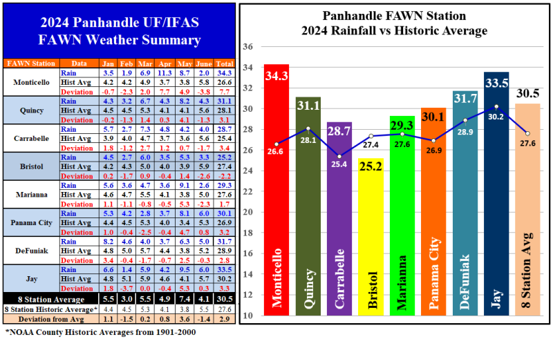
The eight Florida Automated Weather Network (FAWN) weather stations showed more precise variation in rainfall in June. The station at Monticello only recorded 2″, which was -3.8″ below average. Compare that with the 6″ that fell in Jay and Panama City, which were 0.8″ and 0.3″ above historic average respectively. The average of all eight stations was 4.1″, which was -1.4″ below average.
Through the first half of 2024, the average of all eight stations was 30.5″, that was 2.9″ above average. Despite the low total in June, the Monticello station in had the highest six-month total of 34.3″, which was 7.7″ above normal for Jefferson County. By contrast, only 25.2″ was recorded in Bristol, 2.2″ below average.
–
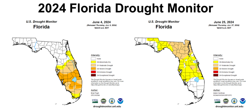
The lower than average rainfall and high temperatures made many of the of the Panhandle counties move into the abnormally dry (yellow) or moderate drought (tan) categories at the end of June. By contrast, Central and South Florida saw significant improvement from the start to the end of June.–
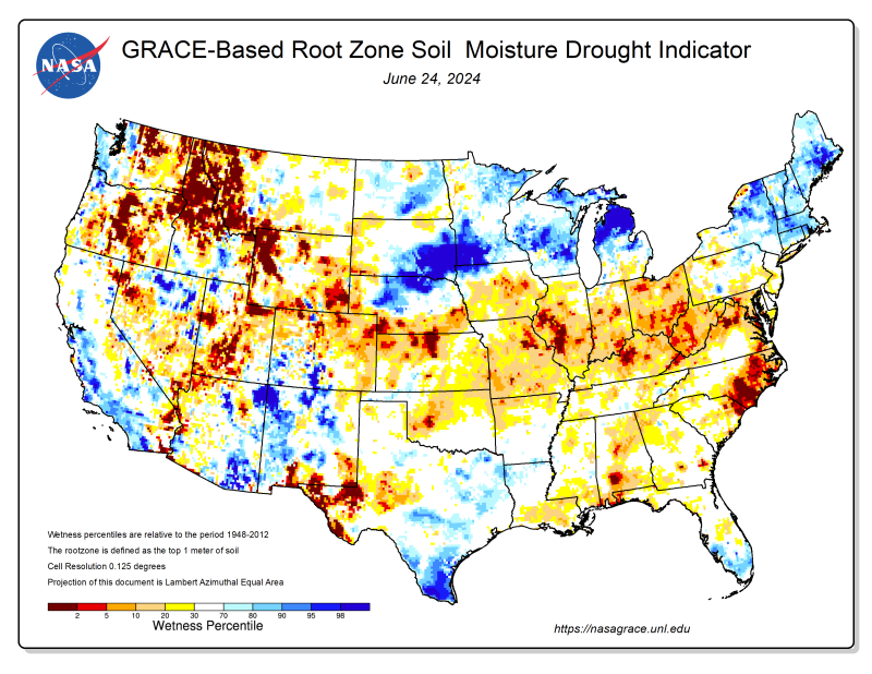 The NASA Root Zone Moisture map from June 24 shows the dry soils developing in several areas of Florida, but especially in the western tip of the state.
 Temperatures
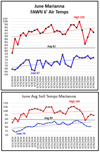
June had the first triple digit temperature of the year, with a total of 7 days over 95°. The month started fairly normal with a low of 67° on June 2nd, 8th, and 9th. Temperatures rose quickly, however, with a high of 100° on June 25th. The average six-foot air temperature was 82°.
The – 4″ soil temperature really heated up from a low of 74° on June 2, to a high of 106° on June 23rd. The average soil temperature was 89°in June.
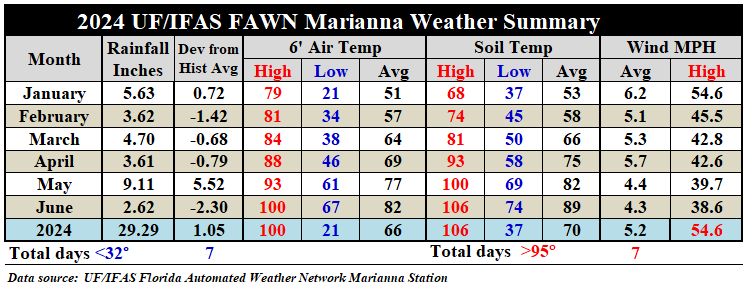
In the table below, you can see that at the Marianna FAWN Station the average air temperature rose 5°, from 77° in May to 82° in June. The average soil temperature rose 7°, from 82° in May to 89° in June.
For more specific details, download the full daily summary from Marianna, and the monthly summary from across the Panhandle:
2024 January-June Jackson Co Weather Summary
–
 –
–
 –
–
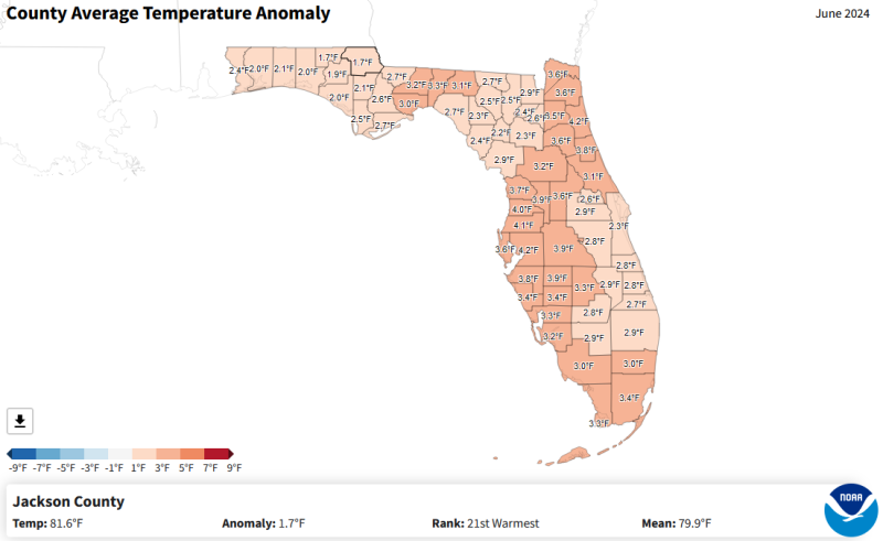
In the map above you can see that every county in Florida was warmer than average in June, ranging from 1.7° to 4.2° above normal. As a whole state, however, Florida’s average air temperature in June was 82.5°, which was the 2nd warmest June on record.
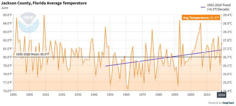 Comparing the June 2024 average air temperature in Jackson County to historic records, you can see that while it was hot this year, it did not surpass the record of 84.9° in 1914, the 84.3° in 1998, or 84.0° in 2011, but was instead the 21st warmest June since 1895. In the county map above, however, you can see that Jackson County was not as warm as other counties in Florida.
3-Month Outlook
 –
–
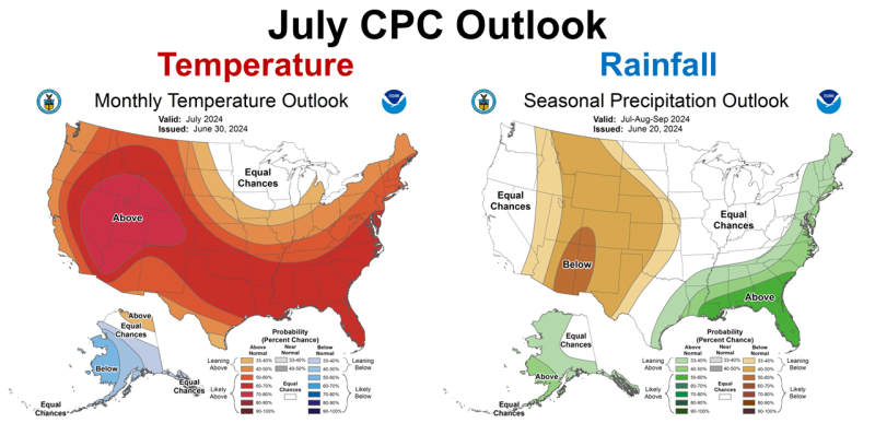
The Climate Prediction Center (CPC) outlook for July calls for continued higher than normal temperatures and rainfall. So, it does appear that short-termed drought relief is expected this month.
–
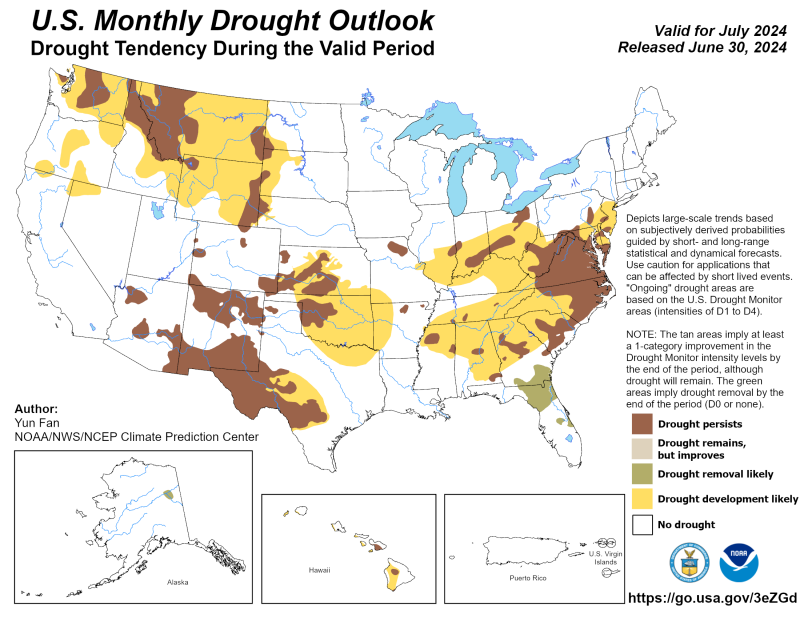
The July CPC Drought Outlook indicates that drought removal is likely for all of Florida in July.
–
 –
–
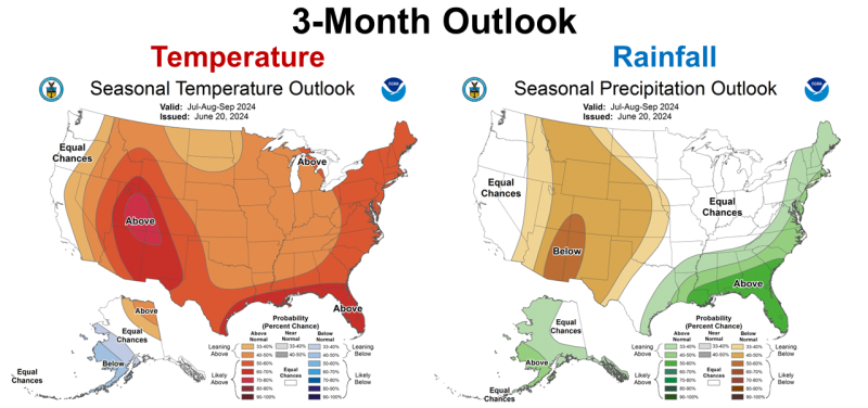
The 3-month CPC outlook for July through September is similar to the July outlook, in that hot and rainy climate is forecast through September. So, at least through September, above normal rainfall is expected to continue.
–
La Niña Watch
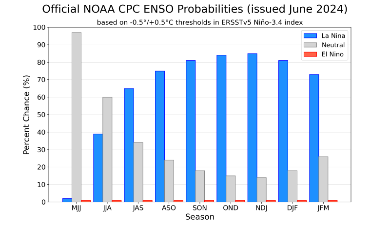
Change is coming, however. The CPC says El Niño is finished and that we are currently in the Neutral ENSO phase, but expects transition to La Niña in the comingh months, with the highest probabilities in the October through January time frame.
 –
–
In the Chart above, you can see that the transition to La Niña is most likely going to affect our climate as we move into the fall and early winter The following, is a quote from the most recent ENSO phase discussion by the CPC.
ENSO-neutral conditions returned during the past month. Near-to-below average sea surface temperatures (SSTs) expanded across the eastern equatorial Pacific Ocean…Below-average subsurface temperatures were mostly unchanged during the past month, with negative anomalies persisting in the eastern half of the Pacific…Collectively, the coupled ocean-atmosphere system reflected ENSO-neutral conditions.
The most recent IRI plume indicates La Niña may develop during July-September 2024 and then persist through the Northern Hemisphere winter. The forecast team is also favoring the development of La Niña during July-September because the rate of cooling has slowed since last month. The team still favors La Niña to emerge sometime during the summer months, given the persistent below-average subsurface ocean temperatures and changes in the tropical atmospheric circulation. In summary, ENSO-neutral conditions are present. La Niña is favored to develop during July-September (65% chance) and persist into the Northern Hemisphere winter 2024-25 (85% chance during November-January). Climate Prediction Center (CPC)
–
What does this mean for Panhandle farmers and ranchers?
The best long-range climate forecast we have says that the short-term flash drought (extreme temperatures with limited rainfall) is likely over. Not to say that there won’t still be some dry periods, but the months ahead should provide adequate rainfall for normal crop and forage production. This won’t make up for your lost yield in June, but it does appear conditions will continue to improve in the months ahead. We do know from recent history though, that La Niña falls can get really dry. We may have good harvest weather for peanuts, cotton, and hay, but pastures and cool-season crop planting might be negatively affected later in the year. Dryland crops may also be negatively affected by limited rainfall to close out 2024. Stay tuned as we know forecasts can change rapidly, but it does look positive for the next three months.

demayo@ufl.edu - 850-482-9620
Follow me on Twitter
@UFCowman
- November 2025 Weather Summary & Winter Outlook - December 5, 2025
- Friday Feature: The History of Beekeeping - December 5, 2025
- Friday Feature:Malone Pecan Festival Tractorcade - November 21, 2025