
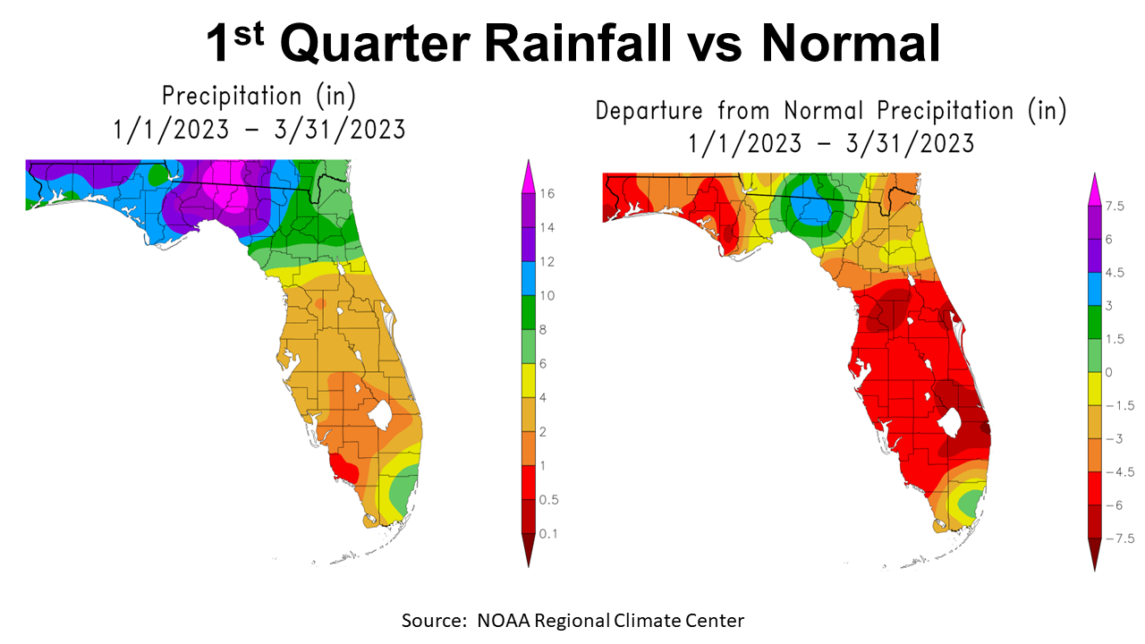
The third straight La Niña winter played out much like it was forecast to be, warm and dry. In the Panhandle, winter rainfall was not at all uniform, as can be seen in the map on the left above. The sections in purple, mauve, and hot pink received more than 12′ in the first three months of 2023. The area shaded in blue received 10-12″, and the dark green 8-10″. That sounds like decent three-month totals, but the map to the right above shows how 2023 compared with historic average. The above average rainfall brought drought relief to the Big Bend Region, but much of the Panhandle was 1-6″ below normal through the 1st quarter of 2023.
–
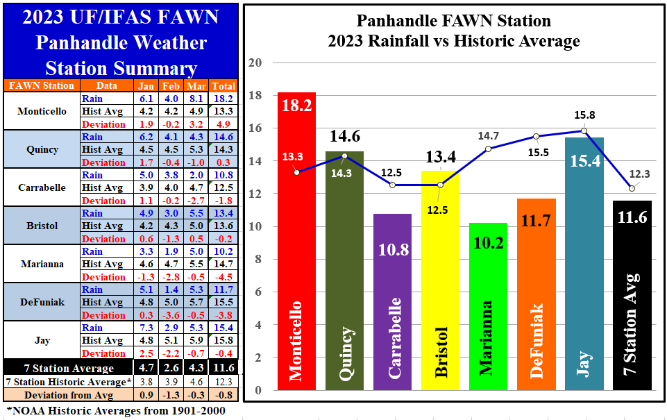
More precise comparisons can be made by using the actual rainfall measured at the seven Florida Automated Weather Network (FAWN) stations in the Panhandle. You may have noticed that I have added the station in Bristol (Liberty County) that was added to the FAWN System last year. I have also adjusted the historic average for each county based on the NOAA Climate at a Glance County Rankings from the 20th Century. The chart to the left shows actual monthly data compared with the 20th century historic average. The bar chart to the right shows the three month total compared with the average line for each location. The bar chart also shows the range of variation from a period of the year that is normally much more uniform following winter cold fronts.
The wettest location in the Panhandle from January-March was Monticello where 18.4″ were recorded, which was almost 5″ above historic average for Jefferson County. Contrast that to the 10.2″ recorded in Marianna, which was -4.5″ below the Jackson County average. When you combine the data from all seven stations, 11.6″ was the average through March, which was -0.8″ below normal.
–
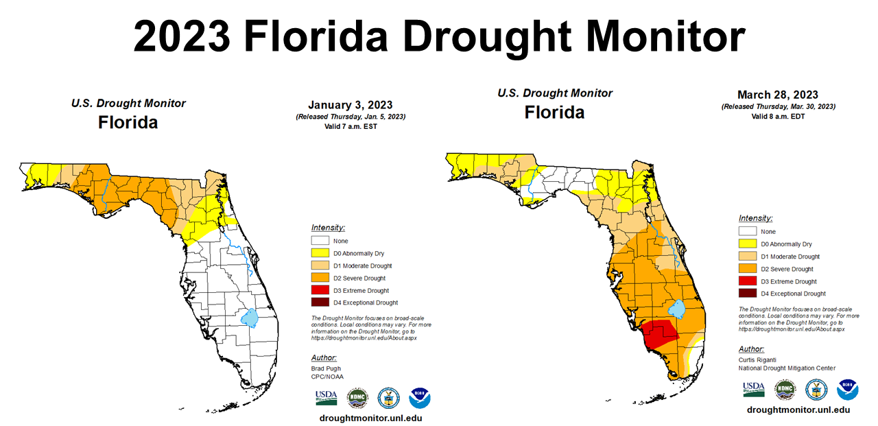
Not surprisingly, the Florida Drought Monitor showed some improvement through the 1st Quarter, but primarily in the Big Bend region. The map to the left shows how dry the Panhandle was at the start of the year. The Peninsula started the year in pretty good shape but got very dry by the end of March. While there was improvement, the counties in the Central Time Zone were abnormally dry (yellow) or in moderate drought (tan) at the end of March.
–
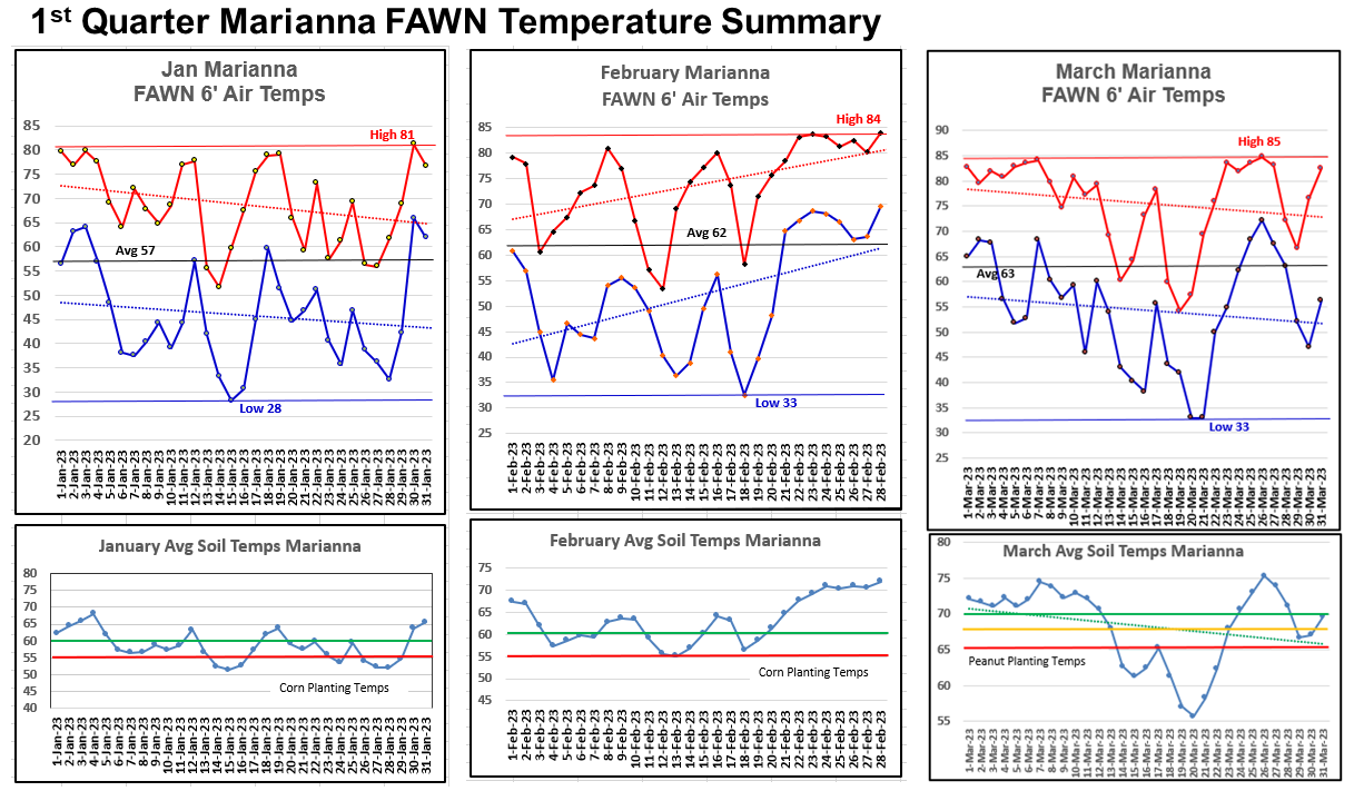
Not only was it dry, it was warm too, except for a few cold snaps. While we got pretty cold at the end of 2022, the low through the first quarter was 28° on January 15, which was one of only two days below freezing from January through March, in Marianna. High temperatures reached over 80° in each of the three months, with a a high of 85° on March 26. The average temperatures for each of the three months were 57° in January, 62° in February, and 63° in March.
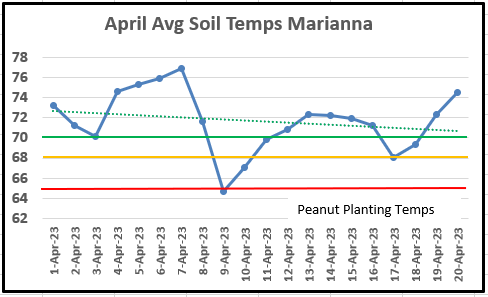
Soil temperatures have also been steadily warming up, with an average of 59° in January, 63° in February, to 68° in March. In the lower graphs above, the red and green lines identify the minimum and recommended soil temperature for corn seed germination in January and February, and peanut seed germination in March. Soils were warm enough to plant corn after February 20 and for peanut planting towards the end of March with some fluctuation. There is an expectation that the end of April will be cooler than average, so keep an eye on average soil temperatures. In the chart below, you can see that average soil temperatures at the Marianna FAWN Station have been jumping around in April but has been above 68° the last three days.
–
Growing Season Outlook
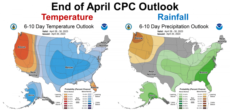
The Climate Prediction Center (CPC) is expecting cooler than average temperatures and above average rainfall in the Southeast to close out the month of April. It does appear that soil moisture will continue to improve as we prepare for warm-season crop planting.
–
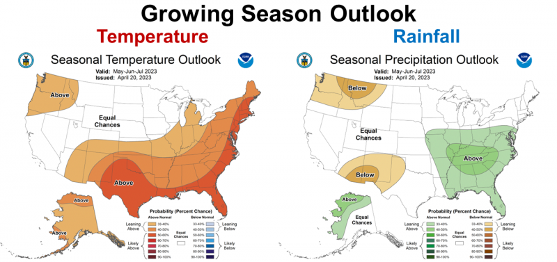
CPC Forecasters are expecting the warmer than average trend to continue over the next three months in Florida. La Niña has officially ended (more on that later), so the outlook for precipitation calls for above average rainfall over the next three months. Welcome news for crop farmers as they begin planting peanuts, cotton, and soybeans. The slight cool down at the end of April should be short-termed as we move into the traditionally warmer months ahead.
–
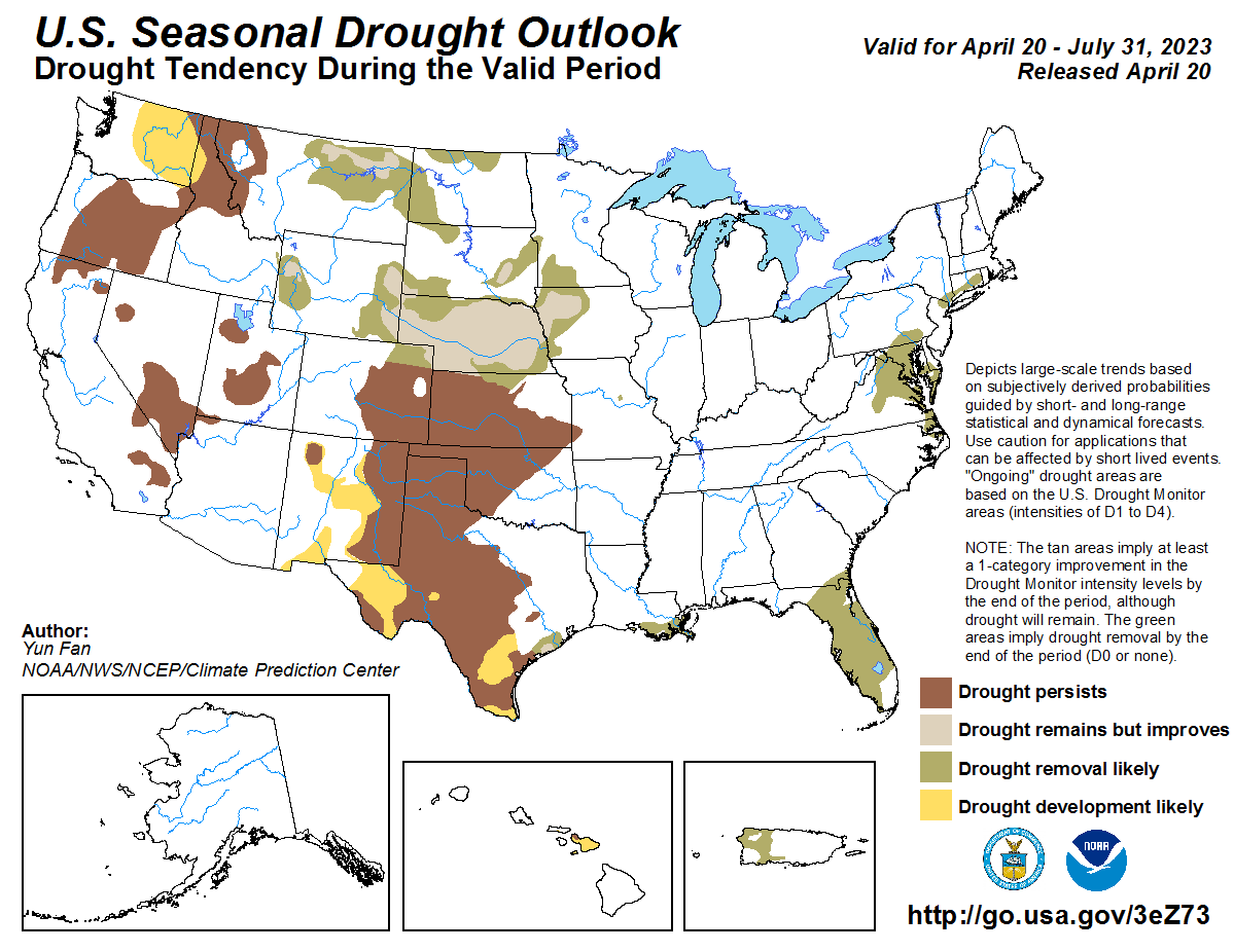
As would be expected from the precipitation outlook, Florida is expected to move out of the Drought Monitor over the next three months. Above average rainfall is expected, so this is good news for Florida. The outlook map above was updated on April 20, and covers through the end of July, however, so it may take some time for the drought removal process to complete. It does appear that climate is changing as we depart from the La Niña ENSO phase.
–
El Niño Watch
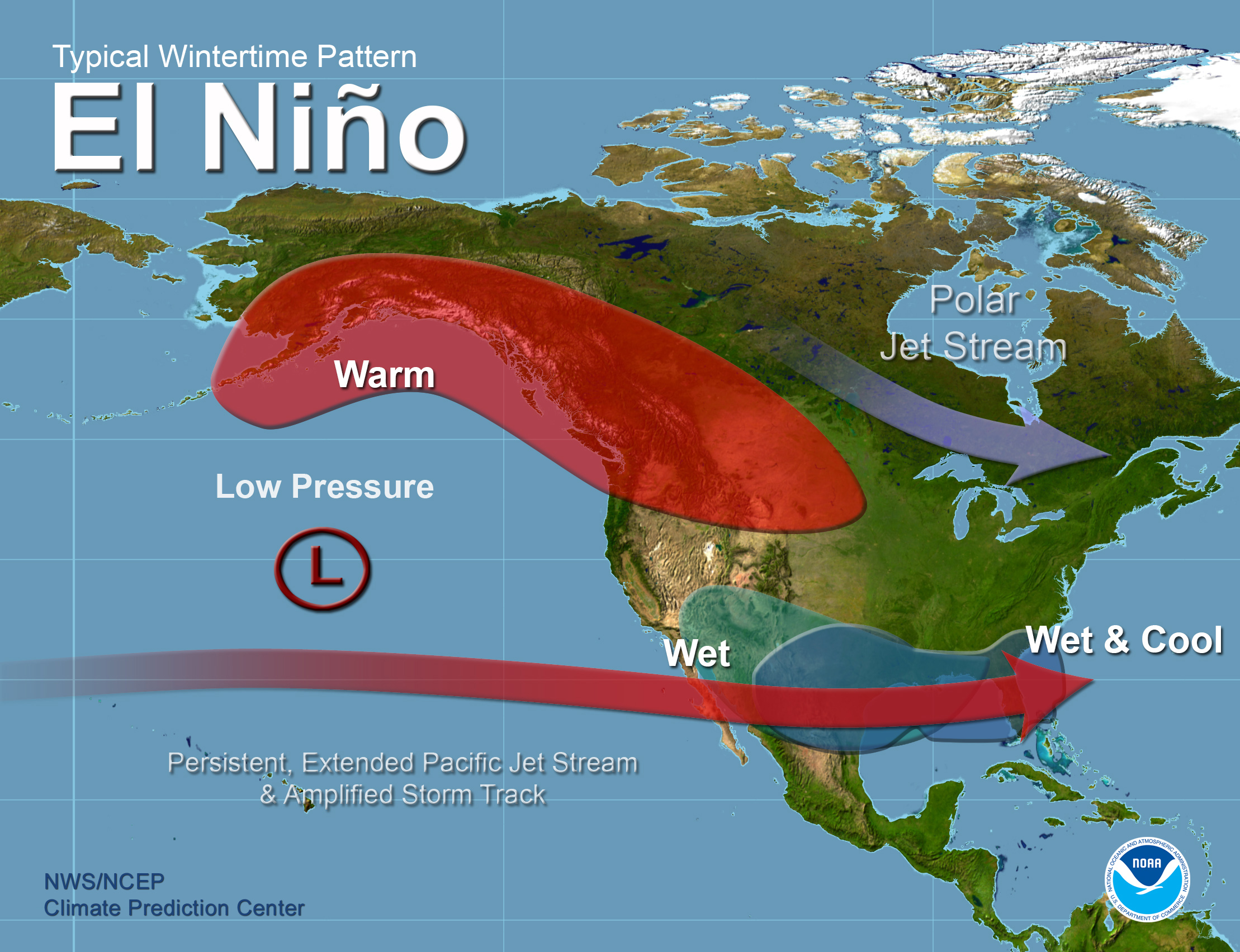
After waiting for three years, La Niña has finally ended, but it is not expected to remain neutral very long, with a good chance of a transition to El Niño in the coming months. The ENSO phases have their greatest impacts on weather in the cool-season (late fall – winter – early spring months). For Florida this would be a real contrast to the past three winters, with wetter than normal and cooler than average temperatures expected.
ENSO–neutral conditions have been observed. Equatorial sea surface temperatures (SSTs) are near–to–above average across most of the Pacific Ocean.
ENSO–neutral conditions are expected to continue through the Northern Hemisphere spring, followed by a 62% chance of El Niño developing during May–
July 2023. Climate Predication Center April 17, 2023
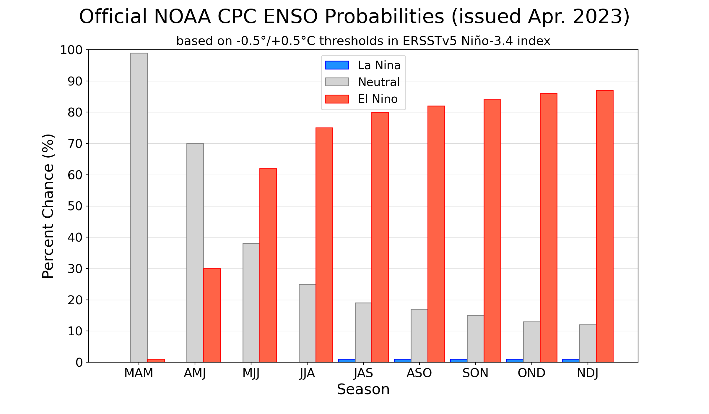
Official ENSO probabilities for the Niño 3.4 sea surface temperature index (5°N-5°S, 120°W-170°W). Figure updated 13 April 2023
–
As you can see from the chart above the current forecast for an upcoming El Niño becomes more certain later in the year. ENSO forecasts are less reliable this early in the year, but the best estimate we have at this point would be an El Niño fall and winter in 2023-24.
–
What does this mean for farmers and ranchers in the Panhandle?
After three years of suffering through La Niña, ENSO neutral is welcomed news. We can expect above rainfall to start the growing season. However, El Niño coming soon is not all good news either. Wet years are not normally top yielding years for crops, so it really depends on how much above average the rainfall is. There are some positives from this forecast, because with changes to the jet stream direction and strength, hurricanes are less likely in El Niño years. This does not mean there won’t be tropical storms and hurricanes, just fewer of them. Typically with El Niño there is an increase in the frequency and intensity of storms from November through March, resulting in a cooler than average temperatures and wetter than average rainfall. Since CPC forecasters are predicting El Niño starting as early as June-August, the impacts will likely be felt this fall. A dry harvest season may not be as likely this year. Utilizing earlier plantings or earlier maturing varieties in some fields might reduce risk this year, if we do have a wetter than normal growing season. Hay quality may be an issue as well, if frequent rains prevent timely harvest. Just remember that spring ENSO forecasts are not as reliable as later in the year, so this is something to keep watching as it develops over the coming months. The main point here is that management of crops and forages in the cool-season should be different than the previous three years. It does appear we are headed for wetter than average year at some point. Early indications are that this may be a moderate to strong El Niño, so we need to pay attention to the predictions over the coming months.
demayo@ufl.edu - 850-482-9620
Follow me on Twitter
@UFCowman
- Friday Feature:Capitalizing on Good Cow-Calf Management - May 3, 2024
- 1st Quarter 2024 Weather Summary & Planting Season Outlook - April 26, 2024
- Friday Feature:Peanut Season Kicks Off at McArthur Farms - April 26, 2024