
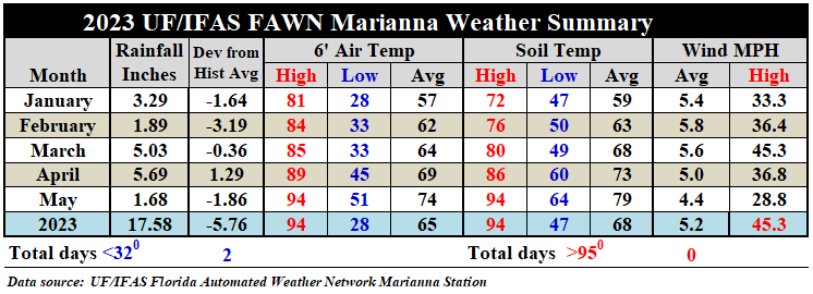
Rainfall
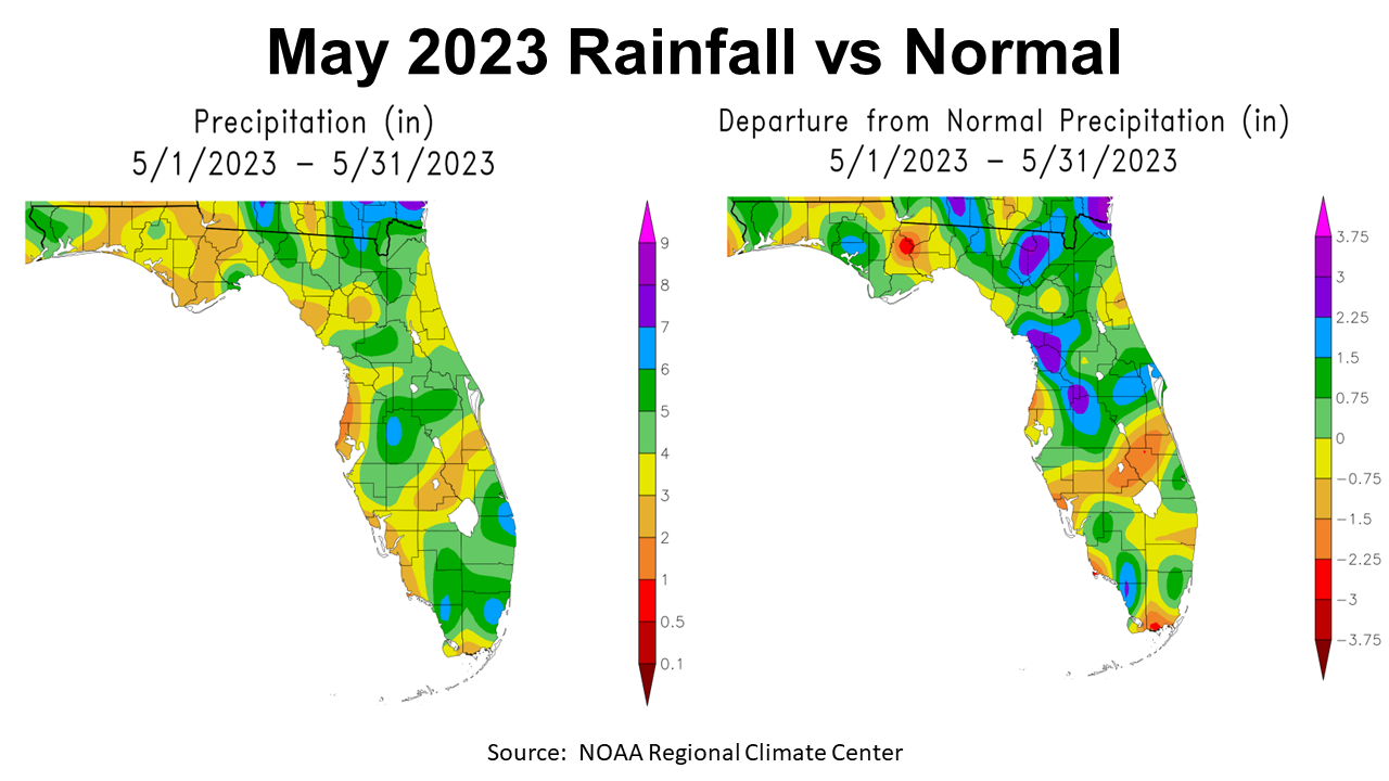
May rainfall was highly variable across the Panhandle with a big temperature swing. The map to the left above shows the estimated rainfall from May 2023. Only the portions shaded in green received 4-6″ for the month, the areas in yellow 3-4″, and in tan 2-3″. May is traditionally one of the driest months in the Panhandle, but the map to the right above compares actual rainfall to historic average. The areas shaded in blue were 1.5-2.25″ above average, in dark green were 0.27″-1.5″ above average, and the light green 0-.75″ above average. The areas in yellow were slightly below average, and those shaded tan, orange, and red were well below average in May 2023.
–
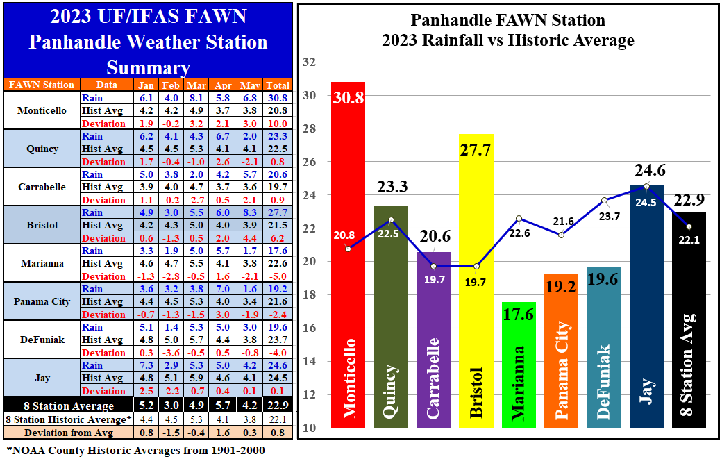
The eight Panhandle FAWN Stations show more precise rainfall variation for the region. The wettest location was 8.3″ of rain in Bristol, which was 4.4″ above historic average. Not far behind was the 6.8″ that fell in Monticello, 3″ above normal. Compare that with the 1.6″ in Panama City and 1.7″ in Marianna that were -1.9″ and -2.1″ below average respectively. The average for all eight FAWN Stations was 4.2″ in May, 0.3″ above normal.
Through the first five months of 2023, the location with the highest rainfall total was Monticello with 30.8″, a full 10″ above average for this period. The lowest total of 17.6″ was recorded at the station near Marianna, -5″ blow normal. The average of all eight locations was 22.9″, 0.8″ above average.
–
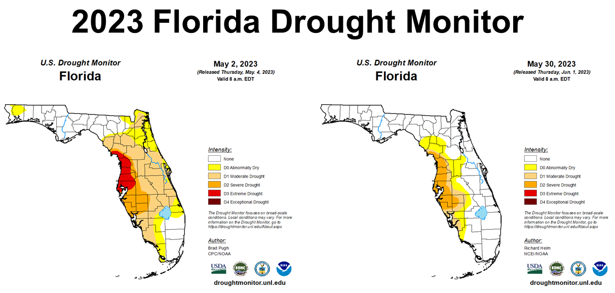
Fortunately, May Rains have made some improvement in the drought situation in Florida. All of North Florida was out of the drought monitor at the end of May. The West Coast of Florida is still in Drought, but at least moved out of the Extreme category.
–
Temperatures
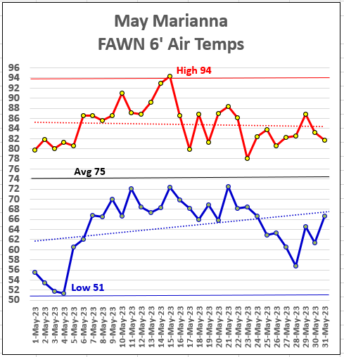 May 2023 had a wide range of temperatures. Temperatures ranged 43°, from a low of 51° on the morning of May 4, to a high of 94° on May 15. It looked like things were really going to start heating up and then it got much cooler, with temperatures holding in the 60s to 80s through the end of the month. That was the mildest Memorial Day Weekend I can remember in my lifetime. The average air temperature for the month was 75°.
–
As compared to April, the average air temperate rose 5° in May from 69° to 74°. Average soil temperatures warmed from 73° in April to 79° in May.
–
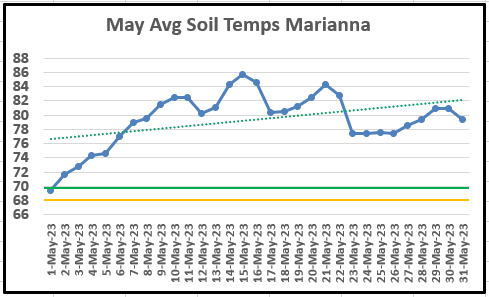
As you can see from the graph above, soil temperatures were ideal (70°+) for peanut seed germination from May 2 through the end of the month.
–
Summer Outlook
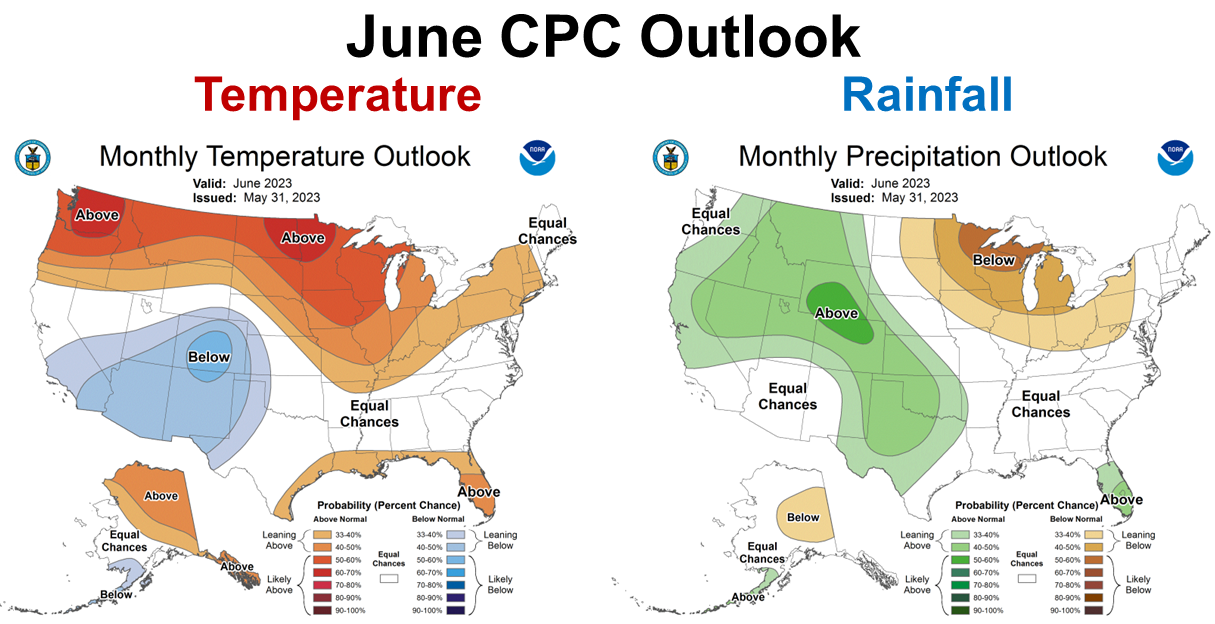
The Climate Prediction Center (CPC) is expecting above average temperatures across Florida in June, and above average rainfall in the Florida Peninsula, but made no prediction for rainfall across North Florida.
–
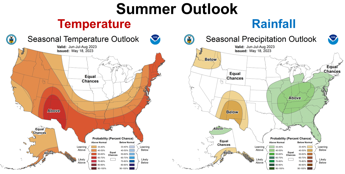
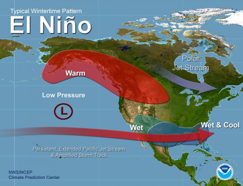
The longer ranged, Summer 3-Month Outlook from June through August, 2023 shows that the CPC is expecting a hot and wet summer ahead. Much of this forecast was based on the transition to El Niño.
–
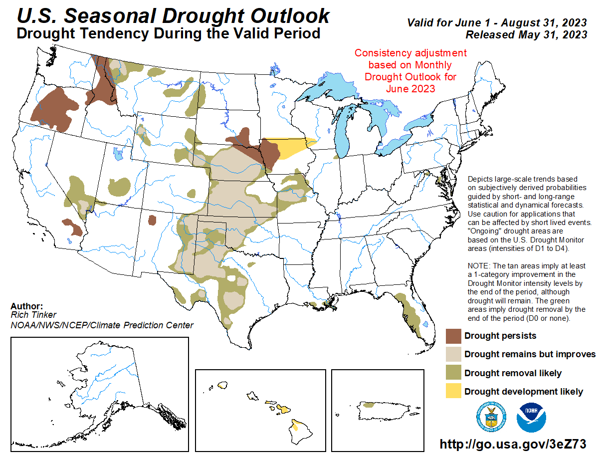
There is good news in this forecast. The CPC is expecting drought improvement for all of Florida, and most of the rest of the country as we progress through the summer. There are still pockets that are expected to remain dry, but most of the US will likely benefit from summer rains this year.
–
 El Niño Advisory
It is official now. The CPC announced this week that El Niño is here and will get stronger later in the year, as the ENSO phases have the greatest impact in the cool-season months.
El Niño conditions are present and are expected to gradually strengthen. In May, weak El Niño conditions emerged as above-average sea surface temperatures (SSTs) strengthened across the equatorial Pacific Ocean. For the May average, low-level wind anomalies were westerly over the western equatorial Pacific Ocean, while upper-level wind anomalies were westerly over the eastern Pacific Ocean. Collectively, the coupled ocean-atmosphere system reflected the emergence of El Niño conditions. Confidence in the occurrence of El Niño increases into the fall, reflecting the expectation that seasonally averaged Niño-3.4 index values will continue to increase. Another downwelling Kelvin wave is emerging in the western Pacific Ocean, and westerly wind anomalies are forecasted to recur over the western Pacific. At its peak, the chance of a strong El Niño is nearly the same as it was last month, with an 84% chance of exceeding moderate strength (Niño-3.4 ≥ 1.0°C). In summary, El Niño conditions are present and are expected to gradually strengthen into the Northern Hemisphere winter 2023-24. Climate predication Center
–
Pam Knox, UGA Agricultural Climatologist shared the following in her Climate and Agriculture in the Southeast blog article:
On June 8, NOAA’s Climate Prediction Center announced that El Niño is here and is expected to get stronger over the next few months. It is expected to last into at least spring 2024, which is as far ahead as the predictions show in their graphics. The ocean temperatures have been in place for a while already, but NOAA was waiting to see the atmosphere respond to those conditions before the official determination was made.
We are unlikely to see a drought this summer and fall, although fall could be drier than normal due to fewer tropical storms in the Atlantic. But if winter El Niño conditions come on early this year as some climatologists expect, we could see a wet late fall as well. The climate next winter is likely to be cooler and wetter than normal, with cloudy conditions associated with the storm track keeping daytime temperatures cooler than expected, although overnight lows may not be extremely cold since cloud cover will keep temperatures from dropping as much as clear skies.
–
What does this mean for farmers and ranchers in the Panhandle?
All indications are that this will be a wetter than average growing season this year. There should also be fewer tropical storms this year, but that does not mean there won’t be serious storms. Remember Hurricane Michael hit the Panhandle in 2018, which was a weak El Niño year. Fewer storms reduces the odds though, so that is good. Last season we had an extended period with limited rainfall to interfere with hay, peanut and cotton harvest. That looks less likely this season. It may be a year when the investment in baleage equipment pays off. Just because it is expected to wetter than average also does not mean there will not be some dry spells, so I wouldn’t turn off the power to your irrigation pump. The greatest impact of a moderate to strong El Niño will come later in the year and through the winter, so plan your cool-season plantings for a wetter climate than the last three years. Stay tuned as this year’s climate forecast become more certain as we move later in the year.
demayo@ufl.edu - 850-482-9620
Follow me on Twitter
@UFCowman
- 1st Quarter 2024 Weather Summary & Planting Season Outlook - April 26, 2024
- Friday Feature:Peanut Season Kicks Off at McArthur Farms - April 26, 2024
- Friday Feature:Artificial Intelligence in a Weed Control Machine - April 19, 2024