
Rainfall
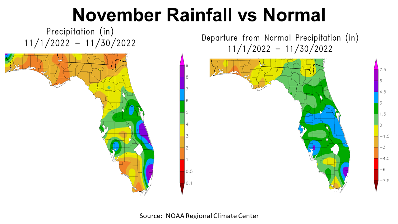
November was yet another dry month for much of the Panhandle. Tropical Storm Nicole and a few cold fronts brought some drought relief to Northwest Florida, but not enough to end the current drought. In the map above to the left you can see that only a small section of Escambia County received between 4-6″ (green & blue) in November, while much of the Panhandle received 2-3″ (gold), but there were areas that received less than 2″ (orange). The map above to the right shows how November rainfall totals compared to historic average for each region. Only the southern tip of Jefferson County was above average (green), but the rest of the Panhandle was below average (gold, tan, orange) for the month of November.
–
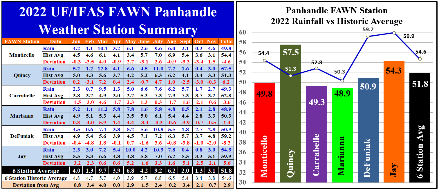
The data from the six Florida Automated Weather Network (FAWN) stations show more precise rainfall totals in November and through 11 months of 2022. Thanks in part to Tropical Storm Nicole, the station in Monticello recorded 4.6″, which was 1.5″ above normal for the month. In contrast, the driest location was Carrabelle, with 2.7″ and was -0.6″ below average. The six station average was 3.1″, -0.7″ below normal.
From January through November of 2022 the direst station was Marianna, with only 48.9″, -1.4″ below average. The station in Quincy has recorded the highest rainfall total of 57.5″, 6.2″ above historic average. The FAWN station in Quincy was the only one above historic average for the year thus far. The average for all six stations was 51.8″, -2.9″ below normal.
–
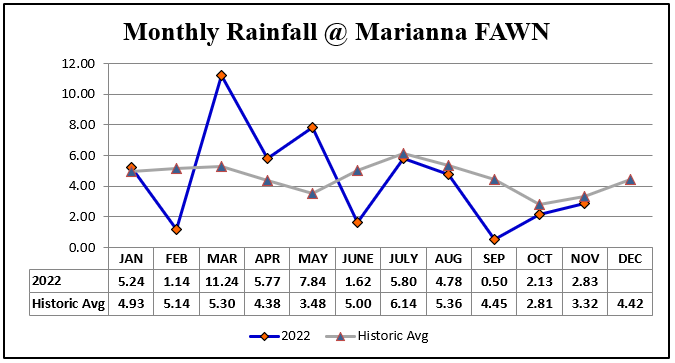
When you look at the rainfall at the Marianna FAWN station in 2022 compared with the 70 year historic average for this location, you can see that the last six months have been below normal, with the biggest deficits in June and September.
–
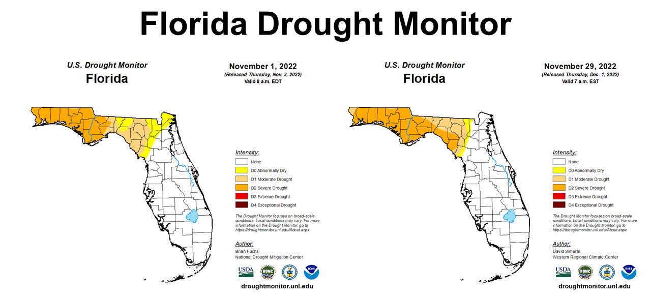
The Florida Drought Monitor maps above show that moderate and severe drought expanded across the Panhandle, from November 1 (left) through November 29 (right). These maps indicate that Tropical Storm Nicole’s rainfall did not remove the region from the drought categories.
–
 Temperatures
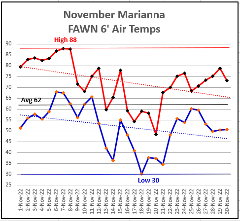
The graph above was created from temperature readings from the Marianna FAWN station in November. We started the month really warm, with a high of 88° on November 7 & 8. Not long after, however, we had a significant cool down to the low of 30° on November 18th. There was 58° spread in the temperature range recorded in November 2022.
–
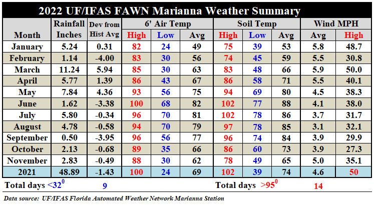
When compared to the previous month, the average air temperature dropped 4°, from an average of 66° in October to 62° in November. The average soil temperature dropped 8°, from 73° in October to 65° in November. In this chart you can also see that Tropical Storm Nicole peak wind speed was 35.1 mph, at the Marianna Station in November.
Download the complete daily weather summary from the Marianna FAWN station, and the monthly totals from all six FAWN stations in the Panhandle by using the following link: 2022 Jan-Nov Jackson Co Weather Summary
–
Winter Climate Outlook
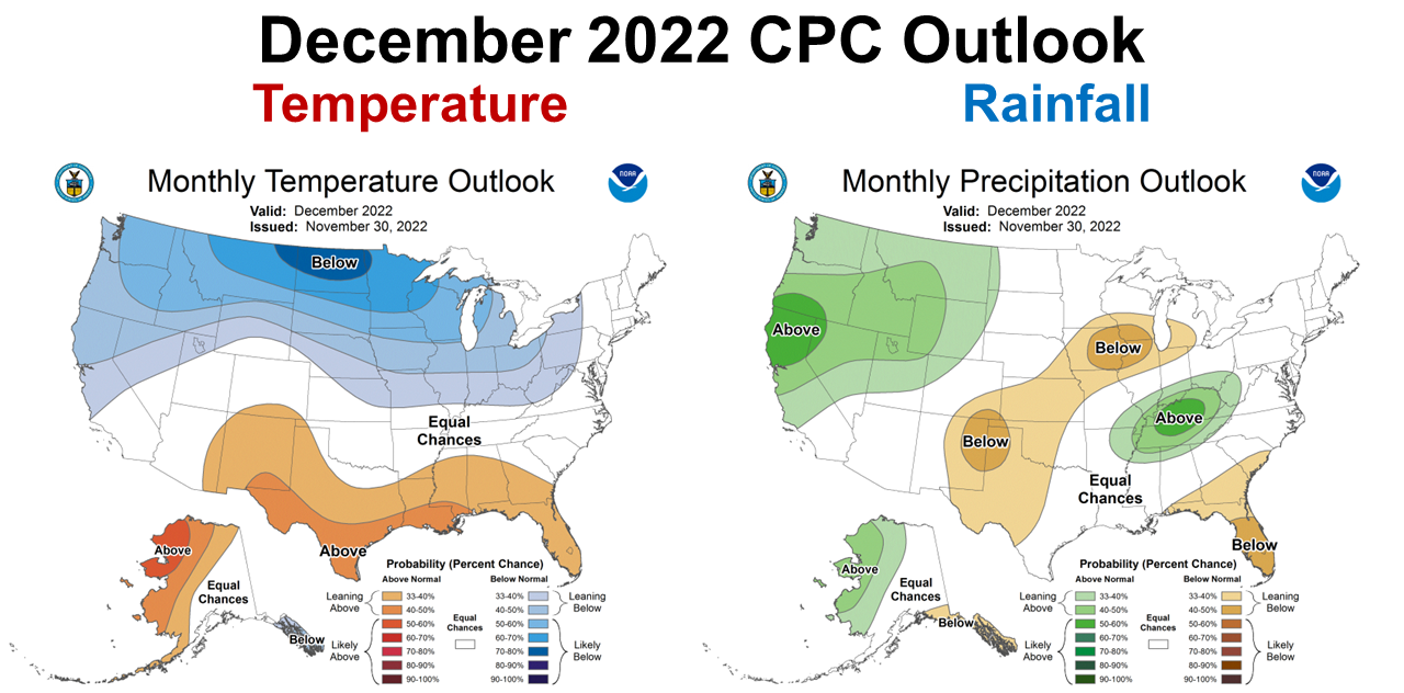
The Climate Prediction Center’s (CPC) climate outlook for December is the same sad story that we have seen for previous months. Warmer and drier than normal conditions are again forecast, based on La Niña wind currents pushing cold fronts north of all of Florida and parts of Southern Alabama and Georgia.
–
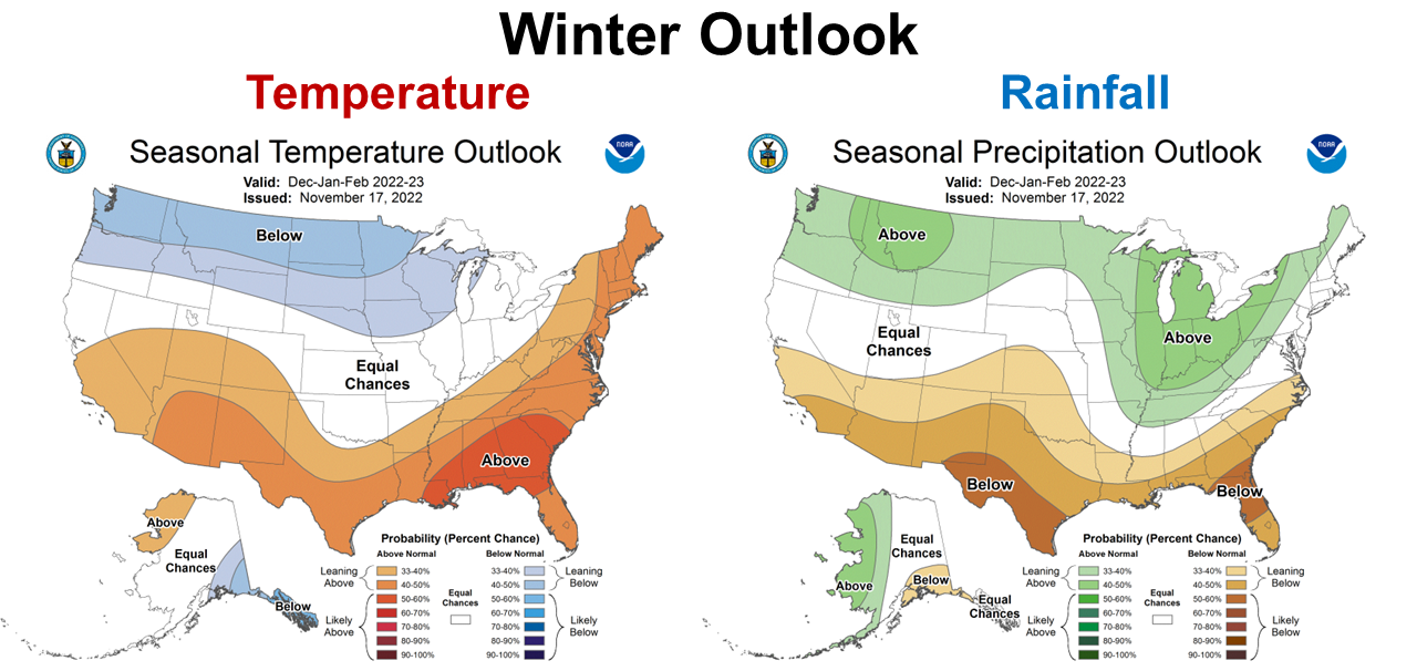
The CPC Winter Outlook (December-February) is similar to the December Outlook, only worse. The CPC is even more certain of warmer and drier than normal forecast for the winter months. Just understand that these climate forecasts are general trends, so this does not mean that it won’t rain or that it won’t get cold through the coming winter. The CPC Outlook estimates how this winter will compare to an average winter. By the way, I checked and the CPC outlooks for precipitation remain dry until you go out to the March-May Outlook that was created in mid-November. It is still too soon to tell when ENSO Neutral will return, but at this point, the CPC is thinking it won’t happen before spring.
–
La Niña Advisory
Round three of La Niña is locked in for this winter. There can be other factors that also affect winter climate, as we have experienced in the previous two winters.
Below-average sea surface temperatures persisted in the central and eastern Pacific Ocean during the past month. In November 2022, negative subsurface temperature anomalies weakened. The most recent IRI plume indicates that La Niña will persist into the Northern Hemisphere winter 2022-23. For the dynamical model averages, ENSO-neutral is favored in January-March 2023, while the statistical model average shows the transition to ENSO-neutral occurs in February-April 2023. The forecaster consensus, which also considers the North American Multi-Model Ensemble (NMME), is split on whether La Niña or ENSO-neutral will prevail during January-March 2023. Regardless, there is higher confidence that ENSO-neutral will emerge by the Northern Hemisphere spring. In summary, La Niña is expected to continue into the winter, with equal chances of La Niña and ENSO-neutral during January-March 2023. In February-April 2023, there is a 71% chance of ENSO-neutral. Climate Prediction Center
Pam Knox, Director of the UGA Weather Network and Agricultural Climatologist, shared the following information in her blog article about exceptions of this year’s La Niña affect on climate in the South.
La Niña conditions are associated with warmer and drier conditions in parts of the Southeast during the winter months, as the jet stream that controls where precipitation-producing storms is shifted to the north towards the Ohio River Valley. This has the highest likelihood of occurrence in North Florida and South Georgia, with lower likelihood in other parts of the region.
However, even if the average conditions are warmer and drier than normal, we can still expect to see some outbreaks of cold air push through the region during the winter, so wet spells and even some snow or ice storms are possible, depending on location. Since the La Niña is also weakening, forecasts for what kinds of climate conditions we might experience are also less reliable than if it were a strong event, and that means other climate events like a Sudden Stratospheric Warming, strong North Atlantic Oscillation, or other factors may provide greater influence on the weather and climate this year. There are some hints now that some of these other factors may bring unusually cold air to the eastern US, especially the northern parts of our region, by mid- to late December, but that is far enough in the future that it is not clear exactly how cold it will get or if any precipitation will be associated with that cold outbreak. Winter and Spring Outlook for 2022-2023 – Climate and Agriculture in the Southeast
–
What does this mean for farmers and ranchers in the Panhandle?
The primary concern is that the current drought conditions will continue until spring. Winter cover and forage crops grown on dryland fields or pastures will likely have reduced production this winter. Small grains grown for grain will likely require irrigation to reach traditional yield goals. Rainfall may return to normal in the spring but it may take some time to replenish soil moisture for spring planted crops to flourish. There is hope for the coming spring. This too shall pass, but how soon? It does appear we can expect a mild but dry winter but when will we see a transition to more normal conditions? Sometime in March or April is the current forecast. Since most of the early spring crops and vegetables are generally planted in irrigated fields, the main challenge will likely be for dryland crop and forage planting in April and May.
demayo@ufl.edu - 850-482-9620
Follow me on Twitter
@UFCowman
- 1st Quarter 2024 Weather Summary & Planting Season Outlook - April 26, 2024
- Friday Feature:Peanut Season Kicks Off at McArthur Farms - April 26, 2024
- Friday Feature:Artificial Intelligence in a Weed Control Machine - April 19, 2024