Rainfall
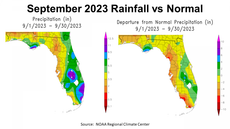
September was another dry month in the Florida Panhandle. Looking at the map to the left above you see the rainfall ranges estimated by NOAA. There were isolated areas that got ample rainfall in September, ranging from 9.5-11″ (purple) to 6.5-8″ (green) along the coast of Gulf and Franklin Counties, but much of the region ranged from 2-3.5″ (tan) or 3.5-5″ (yellow). The map to the right compares this year’s September rainfall to historic average. All of the areas in gold, tan, or orange were below average, with the lone bright spot near the coast in Gulf, Franklin, Liberty, and Wakulla Counties in green or blue.
–
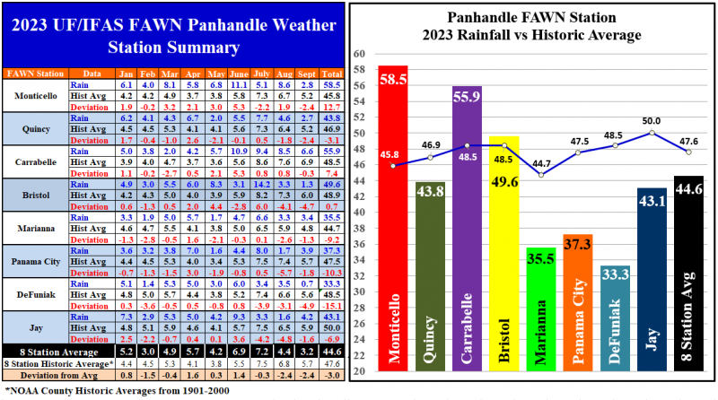
The eight Florida Automated Weather Network (FAWN) Stations in the Panhandle showed more specific variation of rainfall in September. All eight FAWN stations recorded below average rainfall in September. The wettest location was 6.6″ in Carrabelle, which was still -0.3″ below average in September. The direst location was in Bristol, where only 1.3″ was collected, -4.7″ below normal. The average for all eight stations was 3.2″, -2.4″ below average for the month.
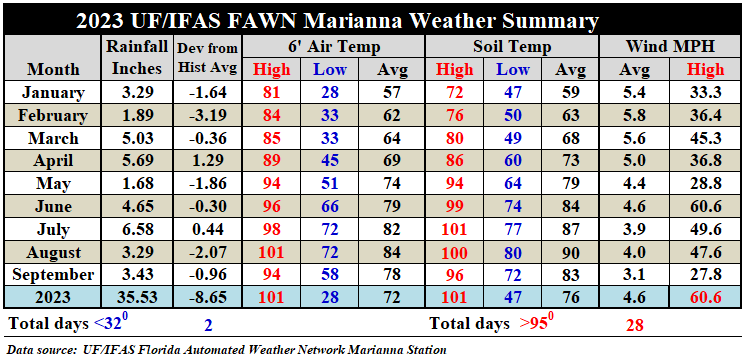
Through the first nine months of September, the average rainfall collected from all eight stations was 44.6″, which was -3″ below normal. The station with the highest rainfall total in 2023 thus far was 58.5″ in Monticello, that was 12.7″ above average. Contrast that with only 33.3″ in DeFuniak (-15.1″) and 35.5″ in Marianna (-9.2″). The bar chart to the right above shows the actual rainfall compared to the county average historical line. Only the Monticello, Carrabelle, and Bristol stations were above normal rainfall through nine months of 2023.
–
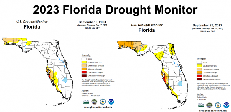
The Florida Drought Monitor from September 5 and 26 shows how the drought conditions expanded through the month of September. The five western-most counties were downgraded into the Severe Drought category at months end. The entire Panhandle was drier than normal in September, but the counties west of the Apalachicola river have been dry for the past two months.
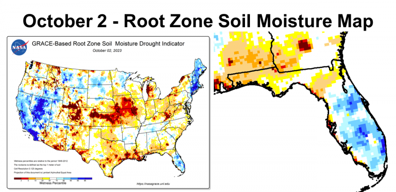
Looking at the NASA Root Zone Soil Moisture Map you can really see how dry the Tri-State area of Southern Alabama, Northwest Florida, and Southwest Georgia have gotten. This area will require significant rainfall to get back to normal.
–
 Temperatures
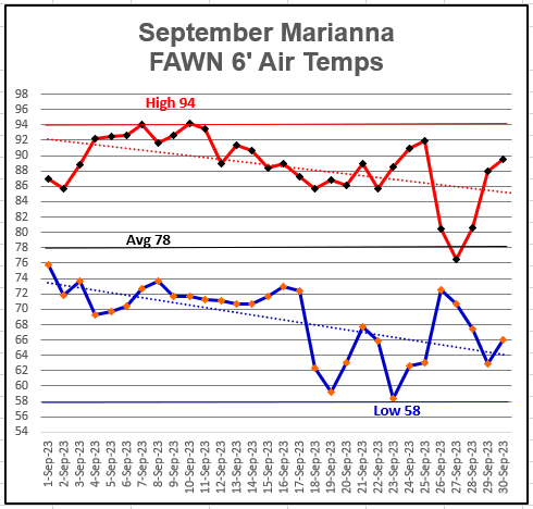
While we did not get a great deal of rainfall in September, there was finally relief from extreme heat at the end of the month. The high for the month was 94° on September 7, 10, & 11, but looking at the trend lines you can see that the morning lows dropped down significantly in the second half of the month, with a low of 58° on September 23. The average 6′ air temperature was 78° in September.
–
Contrasting to August, the average air temperature dropped 6° from 84°to 78° in September. Average soil temperatures dropped 7° from 90° in August to 83° in September. The dog days of summer were brutal this year with 28 days over 95°, but thankfully that came to an end in September.
–
Climate Outlook
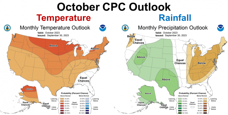
The Climate Prediction Center’s outlook for October is not favorable with a prediction of below average rainfall expected for the Eastern US, but most of Florida was left out of the forecast except for the northern tip of the Panhandle. October is typically one of the driest months of the year, so even average rainfall would not provide significant drought reduction. They are expecting temperatures to be more normal in the Southeast including the entire state of Florida.
–
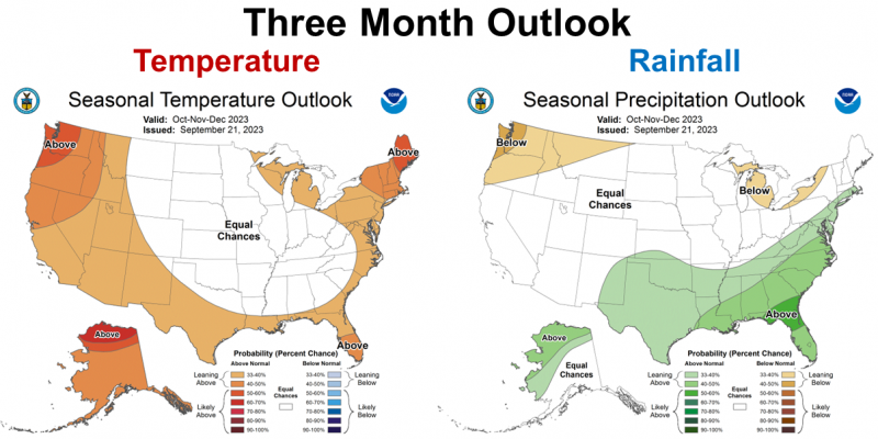
The long-ranged 3-month outlook is more favorable. While the entire state of Florida is predicted to be warmer than average, there is an expectation of El Niño influence increasing rainfall as we move to the end of 2023. Since this was not indicated for October, drought conditions should improve in November or December.
–
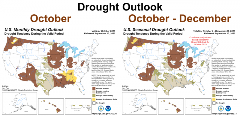
The map above to the left shows the Drought Outlook for October, which is not good for the Panhandle. The map to the right, however shows the expectation of the El Niño influence to provide relief in the coming months. Even so the CPC is not ready to say the drought will end for areas in grey or brown. This makes sense because the Western Panhandle Counties have gotten really dry, so it may take several months of above average rainfall this winter to improve the drought conditions.
–
El Niño Advisory
The experts are still anticipating El Niño to affect the climate this winter. As dry as it has been the last few months, it is hard to see a big change coming, but that is still what they are forecasting. The warmer Pacific Ocean waters affect the jet stream that stears frontal rains further south in the late fall and winter months in El Niño years.
El Niño conditions are observed. Equatorial sea surface temperatures (SSTs) are above average across the central and eastern Pacific Ocean. The tropical Pacific atmospheric anomalies are consistent with El Niño. El Niño is anticipated to continue through the Northern Hemisphere winter (with greater than a 95% chance through January-March 2024). Climate Prediction Center
–
What does this mean for farmers and ranchers in the Panhandle?
For months the Climate Prediction Center (CPC) has been preparing us for a climate change late in the year. The official switch from ENSO neutral to El Niño was made back in mid-June. The key areas of the Pacific Ocean have continued to warm up signaling a strengthening El Niño. But, it has not really kicked in at all yet. El Niño has the greatest impact on cold fronts that move across the country. This weekend will be the first true cold front to pass through the Southeast. Local weather forecasters are not expecting much rainfall in the Panhandle but cooler weather is coming. Hopefully this will be the start of a positive change in our local climate but every year is different, so it is really hard to predict exactly what is coming.
Pam Knox, UGA Agricultural Climatologist, had this to say about the 2023 start of El Niño, in her weekly Ag Climate Blog article: How is the current El Niño expected to affect our winter weather?
On Friday, October 6, the first big cold front of fall will push through a lot of the Southeast, bringing much cooler and drier conditions to the region. It will be a fairly dry front, though, so not much relief from the dry conditions we have been experiencing the past few weeks. Since we are currently in an El Niño, people have been asking me how the El Niño will affect our winter weather. Here are a few thoughts, but keep in mind that each El Niño is unique and so there will likely be a surprise or two in what the winter looks like compared to what we predict using analogs of previous events and statistics. A further complication is the presence of unusually warm ocean waters in the Atlantic and Gulf, due at least in part to the world’s trend towards warmer conditions over time from warming due to greenhouse gases. That means to some extent we are in uncharted territory, since the unusually warm water will heat the atmosphere above it, and that will affect the position of high- and low-pressure centers that help drive the winds across the globe. And there are sometimes wild cards like sudden stratospheric warmings that can alter patterns, too.
Drought relief is expected in the coming months but not immediately. Temperatures have moderated significantly from the extreme heat of the Dog Days, but we all know in Florida that warm weather is likely to return again before winter. It is really dry in the Western Florida Panhandle. It is going to take multiple cold fronts to restore soil moisture. While the clear dry weather is great for peanut and cotton harvest, it makes planting small grains, cover crops, and winter grazing challenging. I heard some good advice from a Forage Specialist several years ago about situations like this. His advice was, “Wait for the second cold front of October to plant.” The main idea was to get a decent rain and then plant right before or soon after the second one comes through. Seedlings can’t live long without topsoil moisture. If you plant into dry soil the seed will sit there waiting for moisture to germinate. However, in October and early November the cold fronts tend to be spread out more than later in the winter. My best advice, “If it is dry as as a Bone, Postpone!” Most of our cool-season forage and cover crops have a recommended planting window of October 1 – November 15. The later you wait to plant the longer you wait to graze as day-length continues to grow shorter at year’s end. This is always the dilemma, should you plant early and hope for moisture or hold out for moisture for good seed germination and steady, fast growth. This year, based on the guidance I have already shared about climate expectations, I would hold off planting for now, unless you have access to irrigation. We also know from experience that planting after Thanksgiving provides lower seasonal yields, as these cool-season crops play out about the same time every year, now matter how late you plant them. There is a possibility of tropical moisture moving through the Gulf next week from Mexico, so there may be a nice planting window in October yet. Have your seed ready so you can plant as soon as you have adequate moisture for success. If El Niño does have a stronger effect at the end of the year, this may be a good winter to grow these crops and forages. When will it get here? That is the big question, but the experts believe it will start in November or December. But these climate experts are not the ones gambling high-priced seed and fertilizer. Be patient, as this drought should end in the near future, but know there are a lot of variables at play between climate and short-term weather.
- 1st Quarter 2024 Weather Summary & Planting Season Outlook - April 26, 2024
- Friday Feature:Peanut Season Kicks Off at McArthur Farms - April 26, 2024
- Friday Feature:Artificial Intelligence in a Weed Control Machine - April 19, 2024

