
Rainfall
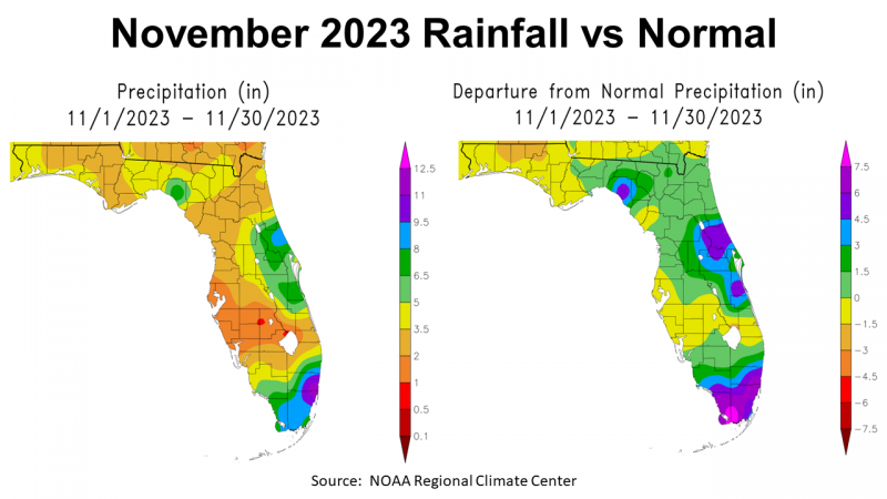
November was another dry month for the Central Time Zone counties in the Panhandle, but the Big Bend counties had more normal rainfall for the month. The map to the left above shows NOAA’s estimated rainfall totals for November. Taylor County was the wet spot with 5-8″ (green), areas in yellow received 3.5-5″, and tan 2-3.5″. The map to the right above contrasts November 2023 rainfall with historic average. Areas shaded in green were 0 to 1.5″ above average, with areas shaded in yellow 0 to -1.5″ below normal, and in tan -1.5 to -3″ below average.
–
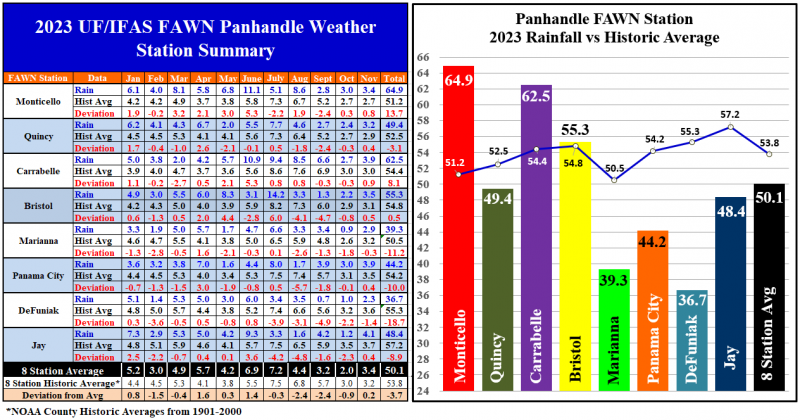
The data from the Florida Automated Weather Network (FAWN) stations provided more precise measurement of the rainfall variation across the eight stations in the Panhandle. For the first time since June, the station in Jay was above average and was the wettest location in November with 4.1″, which was just 0.4″ above normal. Contrast that with only 2.3″ recorded at the DeFuniak Station, which was -1.4″ below normal for the month. The November 2023 average for all eight FAWN stations in the Panhandle was 3.4″, which was 0.2″ above average.
Through 11 months, the driest location overall was at DeFuniak, with only 36.7″, which was -18.7″ below the 55″ historic average for Walton County. Contrast that total with the 64.9″ that was collected in Monticello, which was 13.7″ above average. The average for all eight FAWN stations was 50.1″, -3.7″ below normal. Looking at the bar chart above, the stations are listed east to west, so you clearly see the divide in rainfall in 2023.
–
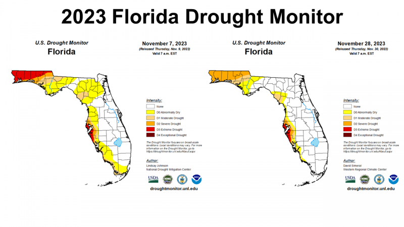
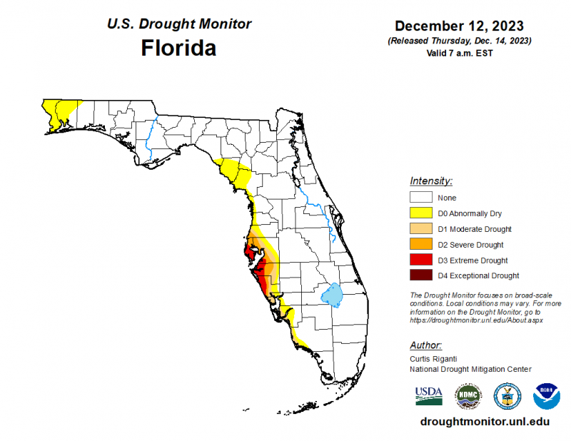 The month of November started with seven Panhandle counties in the red, or Extreme Drought category of the Florida Drought Monitor. At month’s end, there were improvements, but a high percentage of the Panhandle remained in the Severe or Moderate Drought categories. The map to the right shows the most recent drought monitor map for Florida, so December rainfall has made significant improvement to drought in Florida.
–
Temperatures
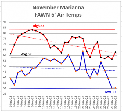
The Panhandle cooled off significantly in November. The 6′ air temperature high of 83° was reached on November 6 and 7. The 30° low temperature came on the morning of November 29. The average air temperature at the FAWN station in Marianna was 59°. The trend lines showed the the daytime high temperatures dropped further than the morning lows.
–
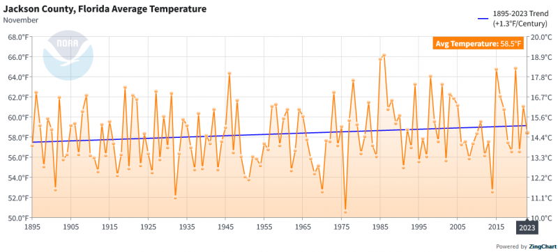
The Chart below shows that November 2023 was actually cooler than the the trend line. Overall you can see how the trend is getting warmer by 1.3° since 1895, but the November 2023 average was 58.5° for Jackson County.
 –
–
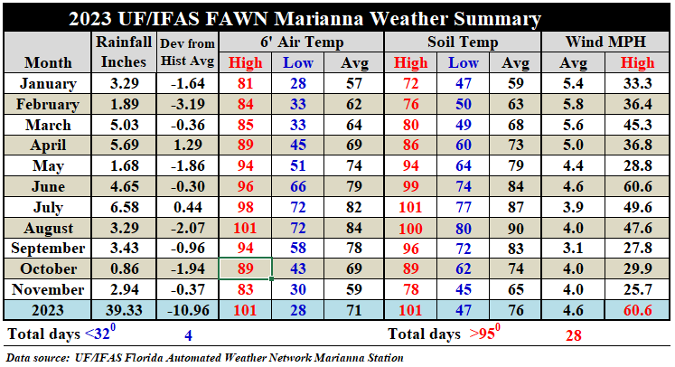
In the 2023 Marianna FAWN weather summary table above, you can see that the 6′ air temperature cooled 10 degrees from 69° in October to 59° in November. Average soil temperatures dropped 11 degrees, from 74° in October to 65° in November.
–
 Winter Climate Outlook
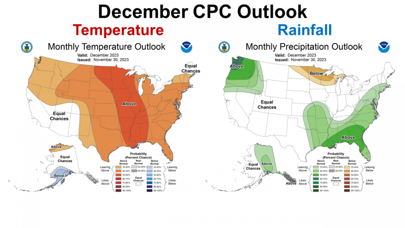
The Climate Prediction Center (CPC) updated their December Climate Outlook at the end of November. The CPC is expecting warmer than average temperatures with high chances of above average rainfall across the Gulf Coastal states in December.
–
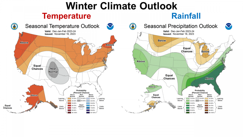 The CPC is expecting a 60-70% chance of above average rainfall across the Southeast this winter, but makes no prediction for temperature variation. El Niño typically brings cooler than average temperatures and wetter than average precipitation, but we have been in a general warming trend for a number of years.
–
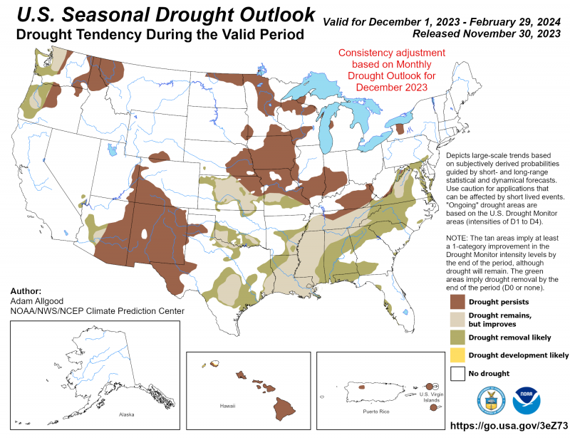
The good news is that above average rainfall this winter is expected to bring drought relief for the Southeastern U.S. Florida in particular is expected to be removed from the Drought Monitor by the end of February. The areas in brown in the Cornbelt, Southwest, and Northwest are the only ones expected to remain in drought this winter.
–
El Niño Advisory
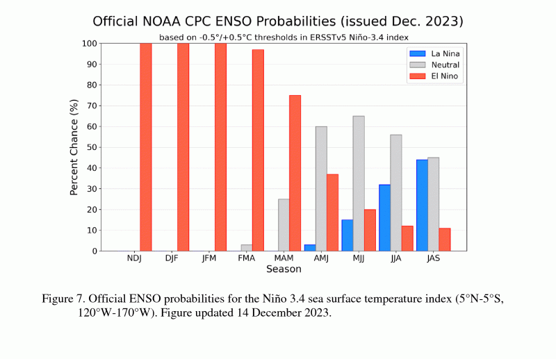
Not much has changed with the latest El Niño Advisory except forecasters are more certain this will be a strong El Niño year. In fact it could one of the strongest events since 1950. Their current forecast is for it to switch back to ENSO Neutral in late spring or early summer. The bar chart below shows the probabilities of each ENSO phase for each three month period.
Sea surface temperatures (SST) were above average across the equatorial Pacific Ocean , increasing in the central and east-central Pacific during November. The growth in SST anomalies, however, abated in early December, with the latest weekly Niño index values at +1.4°C in Niño-4, +1.9°C in Niño-3.4, +2.0°C in Niño-3, and +1.3°C in Niño-1+2…Collectively, the coupled ocean-atmosphere system reflected a strong El Niño.
The most recent IRI plume favors El Niño to continue through the Northern Hemisphere winter 2023-24. Based on the latest forecasts, there is now a 54% chance of a “historically strong” El Niño during the November-January season (≥ 2.0°C in Niño-3.4). An event of this strength would potentially be in the top 5 of El Niño events since 1950. While stronger El Niño events increase the likelihood of El Niño-related climate anomalies, it does not imply expected impacts will emerge in all locations or be of strong intensity. In summary, El Niño is expected to continue through the Northern Hemisphere winter, with a transition to ENSO-neutral favored during April-June 2024 (60% chance). Climate Predication Center – December 14, 2023
 –
–
What does this mean for farmers and ranchers in the Panhandle?
El Niño looks like it is going to provide a wetter than normal winter. They don’t really give us an idea of how wet, but the ENSO influence is expected to be pretty strong. The good news is that it looks like the 2023 drought is coming to an end. While this comes too late to influence warm-season crops and pastures, it should provide ample moisture for cool-season small grains, cover crops, and winter grazing. Soil erosion may be more of an issue this year for fields that do not have a cover crop of some type. It is possible that spring crop planting could be delayed if fields remain wet. At this point, the CPC expects the change to ENSO Neutral in April through June which matches cotton and peanut planting season. After a rough growing season in 2023, the current outlook looks positive for the start of the 2024 crop season, unless of course it gets too wet and delays planting.
demayo@ufl.edu - 850-482-9620
Follow me on Twitter
@UFCowman
- Friday Feature:Capitalizing on Good Cow-Calf Management - May 3, 2024
- 1st Quarter 2024 Weather Summary & Planting Season Outlook - April 26, 2024
- Friday Feature:Peanut Season Kicks Off at McArthur Farms - April 26, 2024