by Andrea Albertin | Jun 6, 2025

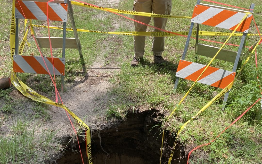
This sinkhole opened up after Hurricane Debby made landfall in Florida’s Big Bend region on August 5, 2024. Image source: Suwannee River Water Management District.
Sinkholes are a natural part of Florida’s landscape, especially in areas where limestone lies close to the surface. If a sinkhole appears on your property, knowing how to respond is key. This article outlines important first steps, available resources, and expert contacts to help you assess the situation and determine what to do.
How do sinkholes form?
Sinkholes form when surface sediments collapse into empty spaces, or cavities, within the limestone bedrock beneath the ground. These cavities develop over time as slightly acidic groundwater slowly dissolves the limestone. When a cavity becomes too large to support the weight of the ground above it, a sudden collapse can occur, creating a noticeable hole at the surface. In some cases, sinkholes can form gradually as sediments slowly settle into cavities over long periods of time, resulting in shallow, bowl-shaped depressions without a sudden collapse.
Limestone underlies our entire state but there are regions where the risk of sinkholes is higher, such as where the limestone is closer to the surface. Although cavities and voids are a feature of carbonate rocks like limestone, few collapse and directly impact roads or buildings.
Where can you find help if you have a sinkhole on your property?
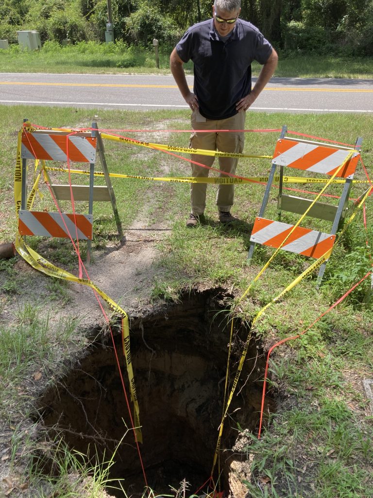
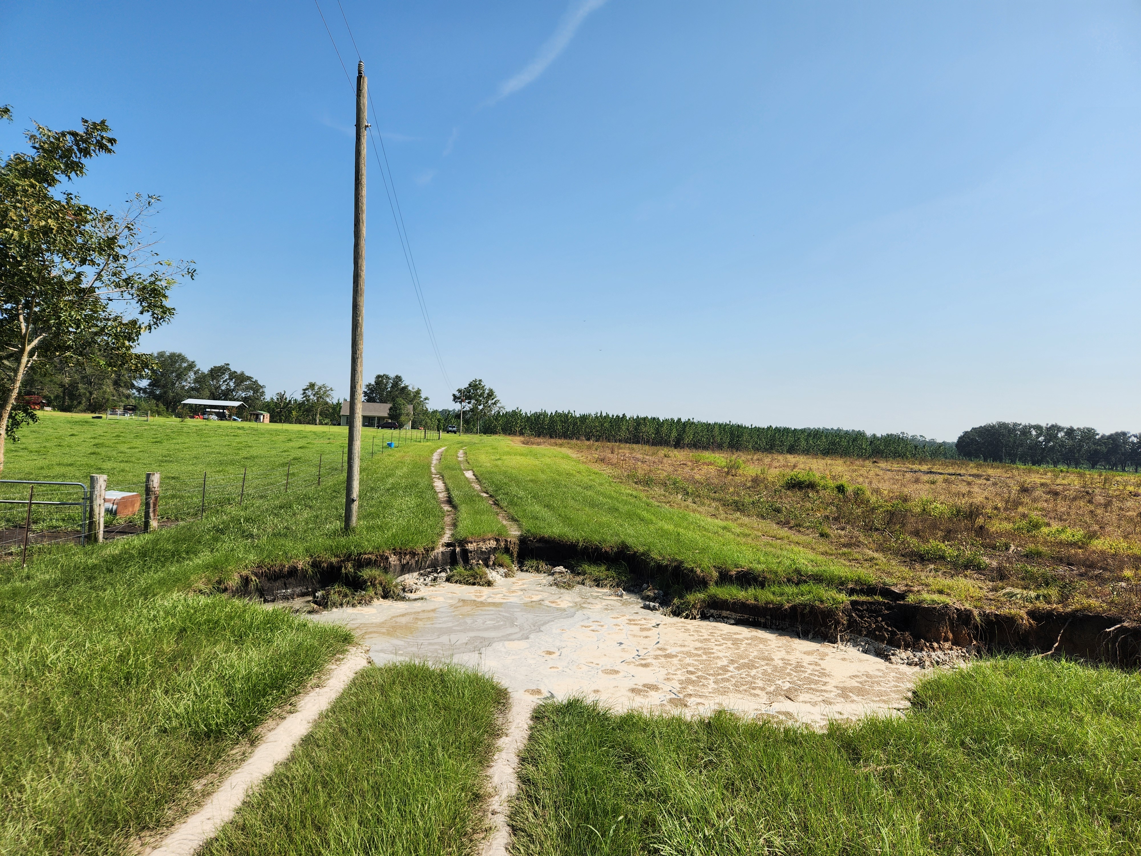
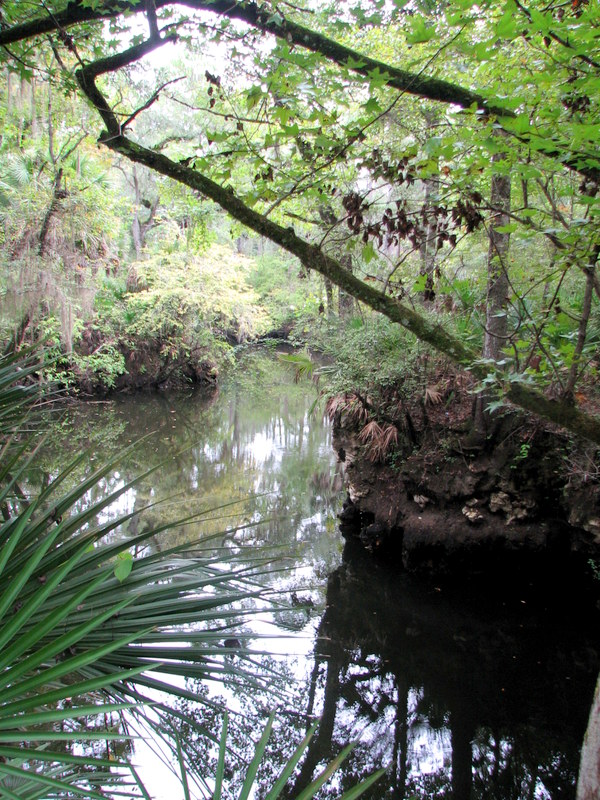
Sinkhole in Union County, FL. Image source: Suwannee River Water Management District
The Florida Geological Survey (FGS), has a Sinkhole Helpline (850 245-2118) as well as a sinkhole website and extensive Sinkhole FAQ to answer residents’ questions. You can speak with someone on the helpline for guidance about what to do (you may not need to do anything) and they can help clarify information found in the FAQ. The FGS also has a leaflet available, A Homeowner’s Guide to Sinkholes in Florida.
You can also contact your Water Management District for guidance. In our region, that would either be the Northwest Florida Water Management District (850 539-5999) if you live in Escambia County to western Jefferson County, or the Suwannee River Water Management District (386 362-1001) if you live in North Central FL, including eastern Jefferson County (Suwannee River WM District Boundary Map).
Here are a few important tips to keep in mind, summarized from the Florida Geological Survey Sinkhole FAQ. Much more detailed information is found on the website. Call the sinkhole helpline or your Water Management District for further clarification on steps to take.
- Call your local law enforcement agency if there is any risk of physical harm.
- For sinkholes under or near structures: Stay out of your house if you suspect the hole is causing or could cause any impact to the structure. In some counties, local government agencies, the sheriff’s office or emergency management office may offer help when a home is endangered.
- Contact your property insurance to see if they cover assessment and repair of damage caused to structures. It’s recommended to mark the hole’s approximate boundaries and document its size by taking photographs and monitoring changes. Do this from a safe distance. Keep children and pets away.
- For sinkholes in your yard, small holes can often be filled with clean sand or soil.
- On large properties, sinkholes that are not actively developing and are not affecting a structure can usually be left alone. If there’s a risk of people or animals falling in, fence or cordon off the sinkhole or you can usually fill the hole with clayey sand (which is preferred) although clean fill material can also be used. Don’t throw anything into a sinkhole or use any fill material that can decompose or leach toxins into groundwater. Call the Sinkhole Helpline for further clarification (850 245-2118).
- Although no permit is usually needed to fill a new sinkhole, sinkholes in wetland areas or those that may change water flow or add to groundwater pollution if filled may need an environmental resources permit (ERP) before filling. Contact your Water Management District or FL Department of Environmental Protection (FDEP) District Office for guidance.
- Keep in mind that other factors besides sinkholes can cause settling on the land surface. These include decomposing stumps, compressed or decomposing garbage and other debris, collapsed or broken sewer pipes and septic systems, soil that wasn’t compacted properly after excavation was completed, among others.
Additional information:
For insurance questions: Dept. of Financial Services – Division of Consumer Services
For information about your rights as a tenant or landlord review the Dept of Agriculture & Consumer Services’ Landlord and Tenet Law
by Sheila Dunning | Jul 23, 2018
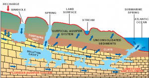
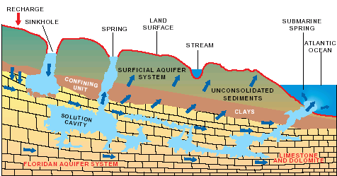
Hydrologic cycle and geologic cross-section image courtesy of Florida Geological Survey Bulletin 31, updated 1984.
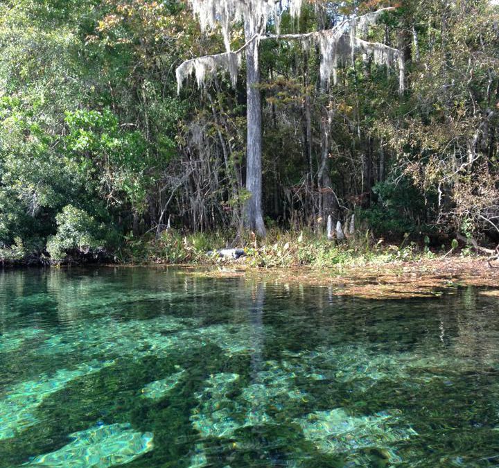
With more than 250 crystal clear springs in Northwest Florida it is just a short road trip to a pristine swimming hole! Springs and their associated flowing water bodies provide important habitat for wildlife and plants. Just as importantly, springs provide people with recreational activities and the opportunity to connect with the natural environment. While paddling your kayak, floating in your tube, or just wading in the cool water, think about the majesty of the springs. They are the visible part of the Florida Aquifer, the below ground source of most Florida’s drinking water.
A spring is a natural opening in the Earth where water emerges from the aquifer to the soil surface. The groundwater is under pressure and flows upward to an opening referred to as a spring vent. Once on the surface, the water contributes to the flow of rivers or other waterbodies. Springs range in size from small seeps to massive pools. Each can be measured by their daily gallon output which is classified as a magnitude. First magnitude springs discharge more than 64.6 million gallons of water each day. Florida has over 30 first magnitude springs. Four of them can be found in the Panhandle – Wakulla Springs and the Gainer Springs Group of 3.
Wakulla Springs is located within Edward Ball Wakulla Springs State Park. The spring vent is located beneath a limestone ledge nearly 180 feet below the land surface. Archaeological evidence suggests that humans have utilized the area for nearly 15,000 years. Native Americans referred to the area as “wakulla” meaning “river of the crying bird”. Wakulla was the home of the Limpkin, a rare wading bird with an odd call.
Over 1,000 years ago, Native Americans used another first magnitude spring, the Gainer Springs group that flow into the Econfina River. “Econfina”, or “natural bridge” in the local native language, got its name from a limestone arch that crossed the creek at the mouth of the spring. General Andrew Jackson and his Army reportedly used the natural bridge on their way west exploring North America. In 1821, one of Jackson’s surveyors, William Gainer, returned to the area and established a homestead. Hence, the naming of the waters as Gainer Springs.
Three major springs flow at 124.6 million gallons of water per day from Gainer Springs Group, some of which is bottled by Culligan Water today. Most of the springs along the Econfina maintain a temperature of 70-71°F year-round. If you are in search of something cooler, you may want to try Ponce de Leon Springs or Morrison Springs which flows between 6.46 and 64.6 million gallons a day. They both stay around 67.8°F. Springs are very cool, clear water with such an importance to all living thing; needing appreciation and protection.
by Rick O'Connor | Nov 6, 2015
Hernando de Soto and his party crossed the Aucilla River sometime in October of 1539 and celebrated Christmas in what is now Tallahassee. Many things in Florida have changed since de Soto passed this way, but when the 2015 Panhandle Outdoors LIVE! tour hiked the Aucilla Sinks portion of the Florida Trail this September, many things had not.
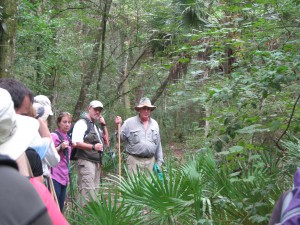
Panhandle residents explore the area of Aucilla Sinks with local guide David Ward.
Photo: Jed Dillard
Yes, the trail is maintained and marked by the Apalachee chapter of the Florida Trail Associations and there are bridges in spots, but the blood sucking bugs that bedeviled deSoto haven’t dissipated. More importantly, the spectacular and distinctive area provides a relatively easy hike that reveals the connections between geology and hydrology in an area with little disturbance by the settlers who followed the first Europeans into North Florida.
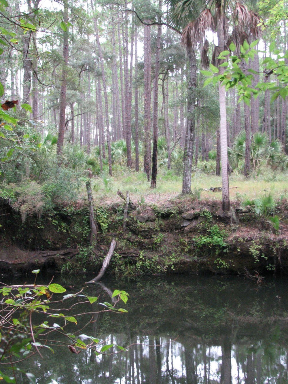
Hikers got up close and personal views of the Karst topography found in North Florida. This topography occurs as the tannic rivers and runoff dissolve the underlying limestone on their way to the aquifer. These connections and voids in the bedrock allow the Aucilla River to “come and go” above and below ground as it moves to the Gulf of Mexico as do all rivers in the Suwannee River Water Management District other than the Suwannee.
Native Jefferson county guide, David Ward pointed out the contrast between tannic water in the river channel and the clear water in caves near the river. “In those caves the water is crystal clear. You are looking at the water of the aquifer itself.”
Leon County agent Will Sheftall seized the opportunity to drive home how vulnerable Floridians are to ground water pollution and its effects on our water supply. “Here there’s little distance between the surface and the ground water. In these sandy soils, water moves quickly from the surface to the aquifer. Whatever is in that water can easily get into our ground water. Our personal activities and our public policies need to reflect that to ensure the future of Florida’s water quality.”
As we reached a slightly elevated area, Ward pointed out a longleaf pine/wiregrass community restored by reinstituting controlled burning. The open vegetation contrasts with the non-fire resistant species such as parsley hawthorn in wetter areas usually untouched by fire. “These pine savannahs were widespread when the Europeans arrived,” Ward noted. “Over my lifetime in these woods, I’ve seen appropriate management bring back these conditions closer to what we know it was like when the Europeans arrived.”

One of the many locations where the Aucilla River “rises from the limestone caverns beneath the earth.
Photo: Jed Dillard
Information on this section of the Florida Trail is available from the Apalachee Chapter of the Florida Trail Association, the Suwannee River Water Management District and Florida Fish and Wildlife Conservation Commission. Humidity never went below 80 percent during our late morning, early afternoon trip. November will likely provide less buggy and surely less muggy conditions. If you’d like to learn about this area from the comfort of your recliner or need some extra encouragement to strike out on the walk, check out this program previously broadcast by WFSU TV. http://wfsu.org/dimensions/viewvideo.php?num=184 Either way, you’ll know more about Florida’s spectacular natural world.
AUTHOR: Jed Dillard; Livestock and Forges Extension Agent; Jefferson County
by Rick O'Connor | Sep 21, 2015
A portion of the Aucilla River flows through a landscape of dramatic and unusual geologic formations. Join us for this tour to see an amazing sequence of sinks and river rises, created as the river alternately disappears into the underlying karst and resurfaces. Fringed with moss-draped trees and native palms, the sinks are pools of black water easily viewed by walking the surrounding embankments along a 4.5 mile-segment of the Florida National Scenic Trail.
Your guides will cover the human history of this wildlife-rich Aucilla River landscape, which extends back 12,000 years to the Pleistocene epoc when mastodons, saber-tooth tigers and other large mammals roamed a landscape that resembled the African savannahs of today. The 1983 unearthing of a 12,000-year old mastodon tusk exhibiting cut marks— evidence of slaughter by humans — provides some of the earliest known evidence of man on this continent.
When: Wednesday, September 30th 2015 ● 10:00 am – 4:00 pm EDT
Where: meet at JR’s Aucilla River Store, 23485 US 98, Lamont, FL 32336 (east of the Aucilla River bridge, the boundary between Jefferson and Taylor counties)
Bring: comfortable hiking boots/shoes, weather-appropriate clothing, hiking stick or trekking pole, water bottle, bug spray, day pack; lunch prepared by Tupelo’s Bakery in Monticello will be provided
Cost: $25.00 per adult
Register at: http://uf-extension-pol-2015-aucilla-sinks-hike.eventbrite.com
Space is limited.
Please feel free to share this announcement and attached flyer with those you know who may be interested. And we hope you can join us for this trip if you’ve never seen this beautiful, mysterious place.
Will Sheftall, for Extension Natural Resource Agents in the Panhandle
sheftall@ufl.edu
by Judy Biss | Apr 13, 2013
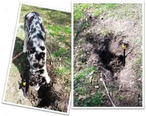
This tiny sinkhole appeared in my yard during the heavy March rains. Although only 3 feet wide, it was 5 feet deep. My dog looks both curious and jealous that it wasn’t one of the holes he’s dug!
During our heavy March rainfall events a tiny sinkhole appeared in my yard. While it was only 3 feet across, it was over 5 feet deep! After reading about the various types and causes of sinkholes, I decided it was most likely a “subsidence incident” sinkhole caused from collapsed underlying organic material (perhaps an old tree root?). Read on to learn more about sinkholes, their causes, and their prevalence in Florida.
Sinkholes are a fascinating, common, and sometimes tragic characteristic of Florida’s landscape. They are one feature of “karst” terrain which is quite prevalent in Florida. Other features of karst terrain include caves, springs, disappearing streams, and underground drainage systems. Karst terrain “is a type of topography that is formed by dissolution of bedrock in areas underlain by limestone, dolostone or, as in some western states, gypsum….The term karst, therefore, refers to the terrain and the term sinkhole is one of the types of drainage features reflected by that type of terrain. Other subterranean events can cause holes, depressions or subsidence of the land surface that may mimic sinkhole activity. These include subsurface expansive clay or organic layers which compress as water is removed, collapsed or broken sewer and drain pipes or broken septic tanks, improperly compacted soil after excavation work, and even buried trash, logs and other debris… Such an event is called a “subsidence incident.” (Source: Florida Dept of Environmental Protection http://dep.state.fl.us/geology/geologictopics/sinkhole.htm)
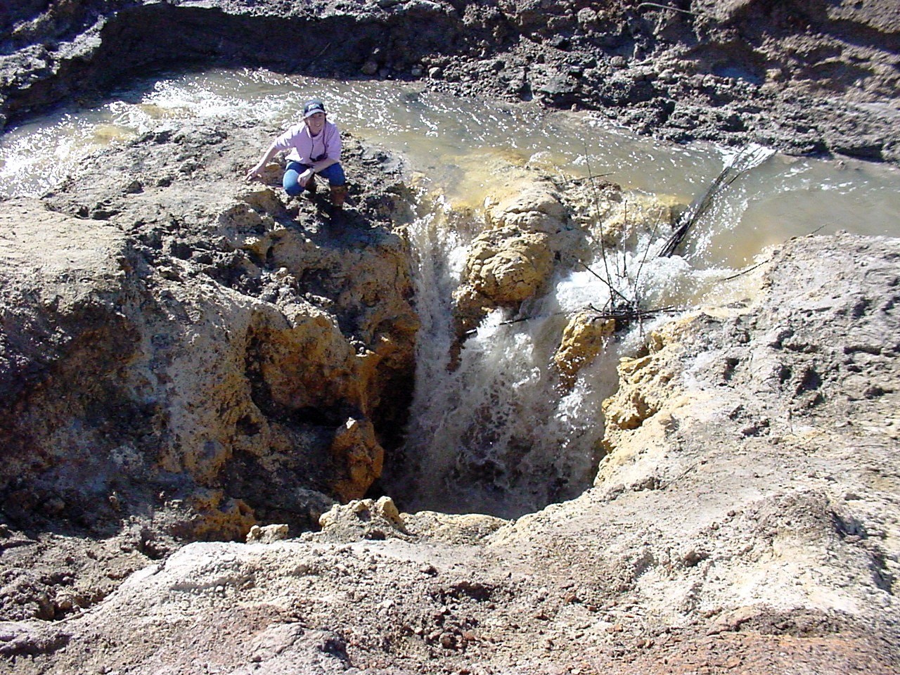
According to the United States Geological Survey and the Florida DEP Bureau of Geology, panhandle Florida’s limestone bedrock is overlain with from zero to over 200 feet of sediments. The depths and types of these overlying sediments are major factors in the prevalence and characteristics of sinkholes and other karst features. View this map to see an overview of sediment depth and sinkhole activity in your county. Leon County, in eastern panhandle Florida, boasts its geologically active Lake Jackson, not only for its famous largemouth bass fishery, but also for its periodic disappearances through underlying sinkholes! This 4,000 acre lake has a history of virtually draining through underlying sinkholes about every 25 years. Its most recent draining event was in 2006.

This is the sinkhole that drained Leon County’s Lake Jackson in 2006. The author is kneeling at its edge.
Please visit the following links for more information, including answers to questions such as:
- I think I have a sinkhole in my yard. What should I do?
- How do I fill in a sinkhole?
- Will watering our lawn lower the water table level and thus, cause sinkholes to develop in our neighborhood?
- Is there a government agency that will come and inspect my sinkhole?
- What is the sinkhole risk factor associated with my area?
- Is there a database showing all sinkholes in Florida?
- Our insurance company has informed us that the area where we are going to purchase property is listed as a sinkhole area. What does this mean? What can we do about it? Should we buy in that area?
Florida DEP, Bureau of Geology, All about Sinkholes, Questions and Answers.
Sinkhole Type, Development, and Distribution in Florida – A Map
UF/IFAS Disaster Handbook – Sinkholes
Sinkholes and Catastrophic Ground Collapse: What Every Floridian Should Know