Each year scientists, resource managers, science educators take some time in February to make the public aware of the invasive species issue. Over the last few decades, I believe this has happened. News articles, fact sheets, public events, even kids’ television programs have covered the topic. You wonder what else needs to be said. But I have found that there is still a lot of confusion about invasive species.
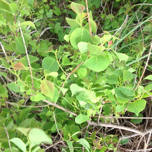
For one… what exactly IS an invasive species. The term is used for almost any creature we do not like or seems to be a problem for us. And on the flip side of that, some species which have been deemed invasive we don’t see a problem with. Many have told me – “What problem does the Chinese Tallow cause? I like this tree in my yard. It is one of the few that shows color in the fall and I want to keep it”.
The Chinese tallow is an invasive species the entire state is dealing with. Photo: Rick O’Connor
There are several characteristics used to identify a creature as invasive but causing an environmental or economic problem is a big one. Many species of vine come to mind. Kudzu, Japanese Climbing Fern, and Old World Climbing fern are good examples. These plants grow rapidly, covering all things in their way – other shrubs, trees, homes, garages, electric wires, and more. You can see them expand like a cancer across the landscape and realize that all other plant life will not be able to compete with them. Then you might realize that animals that depend on those native plants are in trouble as well. And then add into the labor and cost of removing them only to watch the invasion reoccur next year. I know here on Pensacola Bay they have spent thousands of dollars trying to remove kudzu from a shoreline bank near a popular restoration area. Only to find the entire area covered again in a couple of years.
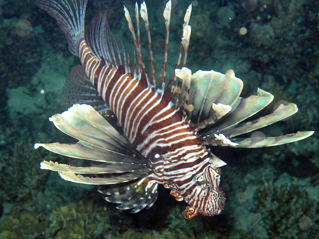
Then there are the invasive animals that have caught our eye. The Burmese python and red lionfish come to mind. Burmese pythons can reach lengths between 15-20 feet and weigh almost 200 pounds. They can consume almost any small mammal in the environment and have even taken on large ones, as well as alligators. There are thousands of them now in heavily populated south Florida and their presence is unnerving to those residents – to say the least.
The Invasive Lionfish
The red lionfish is one of the most successful invasive species ever. After the initial release(s) in southeast Florida in the 1980s they have expanded to cover the entire south Atlantic region. They are opportunistic feeders consuming whatever they can get into their mouths and altering the ecology of our coral reef systems.
But then there are comments I have heard concerning the expanded growth of native muscadine or dewberry vines across one’s yard. “These things are invasive, aren’t they?” Actually… no they are not. They may be problematic, a nuisance, but not invasive. Living in the Florida panhandle I have had residents who have moved here from south Florida ask me whether mangroves would be considered invasive here. But the spread of mangroves north is occurring naturally – so, no it would not.
So… how DO we define an invasive species?
The University of Florida IFAS Extension defines an invasive species as (1) a species not native to the area, (2) a species that was introduced by humans – whether intentional or not, (3) a species that causes either an environmental or economic problem – possibly both.
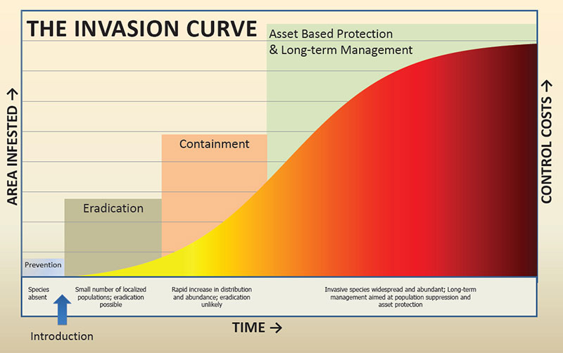
Battling invasive species can be labor intensive and costly. As you can see on the graph below, the best method is preventing the species from ever reaching your area. Easier said than done. First you need to know which species to be on the lookout for. Second you need to know how it is dispersing across the environment before you can prevent it. If you miss the initial invasion, you will see Early Detection and Rapid Response (EDRR) is the next plan of attack.
The Invasive Species Curve
Making the public aware of these species, and the problem, is what NISAW is all about. Helping the public to better understand how to manage the invasive species and prevent new ones from arriving is also a part of this effort. We will post articles about invasive species found in the Florida panhandle throughout the rest of this week. Some are in the red part of the invasive curve. Some are just beginning to be found here. If you ever have questions about a species on your property, you can always reach out to your county extension office for help and advice.
Six months ago, they were predicting a colder than normal winter. In January that seemed to be the case. We had multiple fronts with high winds and temperatures dropping into the 20s. But February has been different. As I type this, it is 62°F and we have had some of the nicest days we have had in a while. Sunny, low humidity, really nice. AND THE GROUNDHOG SAW HIS SHADOW!!! So… maybe an early spring?
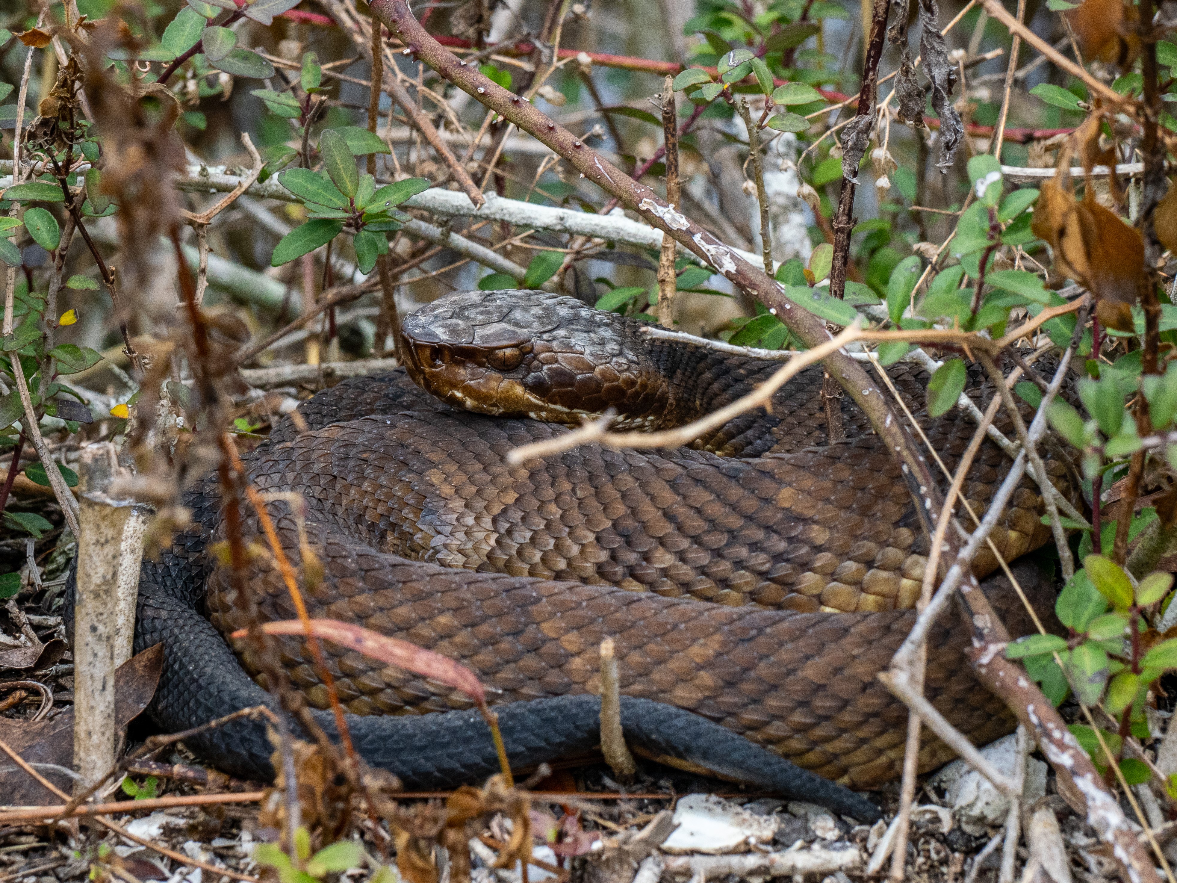
With the warmer temperatures I thought we might encounter some of our ectothermic friends (amphibians and reptiles). On days like we have seen, snakes and turtles will come out from their winter hiding spots to bask in the sun. Since our early winter article, two cottonmouths have been seen on Santa Rosa Island. They were both reported as being very sluggish – but that is to be expected – it is still winter, and the temperatures are still low in the mornings. With that thought in mind we did our February mid-winter hike at Ft. Pickens.
A cottonmouth found on the trail near Ft. Pickens. Photo: Ricky Stackhouse
The hike was on February 6. It was a beautiful sunny day, the temperature was 49°F, light wind from the north. I will say, in the wind it was a bit chilly, but behind the dunes it was very pleasant.
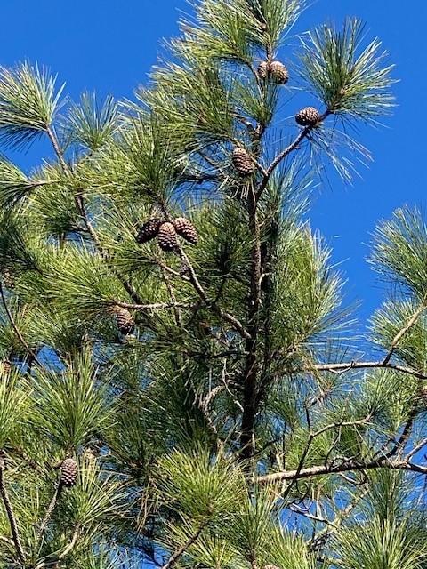
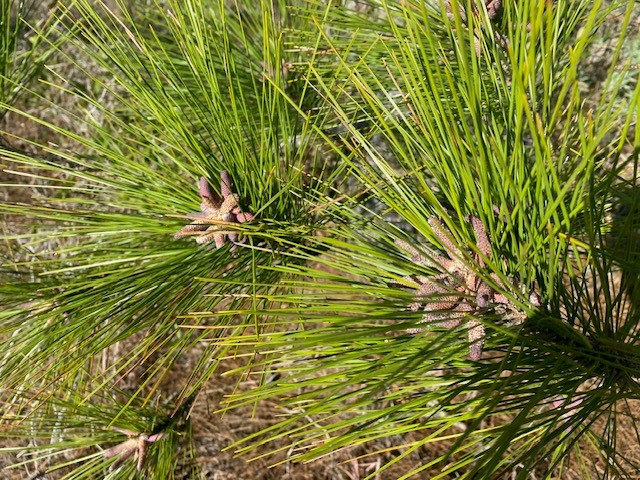
Along the trail I noticed a lot of green plants, but nothing was in bloom. Often the change in temperature can fool flowering plants into blooming early. However, the pine trees were full of male and female cones. They were definitely getting ready for pollen season.
The female cone of a pine tree.
Photo: Rick O’ConnorThe male cones of this pine tree are releasing the all too familiar yellow dust pollen.
Photo: Rick O’Connor
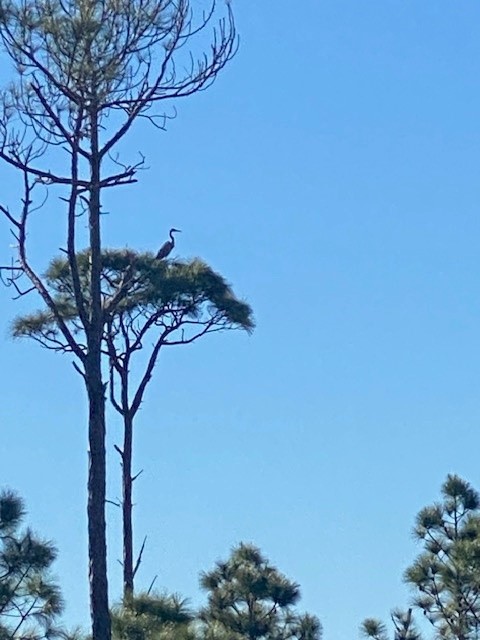
I began in the middle of the island in the hardwoods, moving slowly hoping to find a basking snake. I did not, but I did see numerous woodland songbirds. I am not a good birder, but I believe there were varieties of warblers, titmice, wrens, and the always present mockingbird. I did spot a great blue heron on a nest. Birds are endothermic – and this is their time – a great time to do some birding if you like that.
Blue herons often use the tops of pine trees for nesting.
Photo: Rick O’Connor
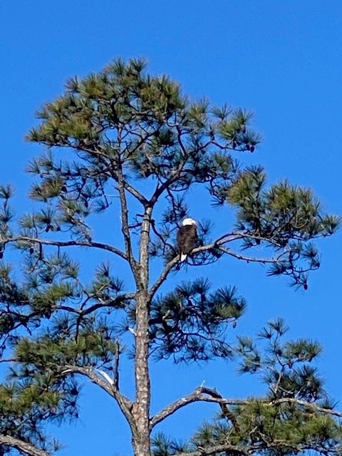
I took another trail heading towards the beach. This crossed through more woodlands before reaching the dunes and the shore. It was in the woodland area I came across a bald eagle nest. Many of us remember a time when we never saw bald eagles around here. Now they are becoming more common and nesting all around the bay area. These awesome birds are similar to dolphins, sea turtles, manatees, and the Blue Angels – you never get tired of seeing them. It is always an exciting moment when one flies over.
The American bald eagle.
Photo: Rick O’Connor
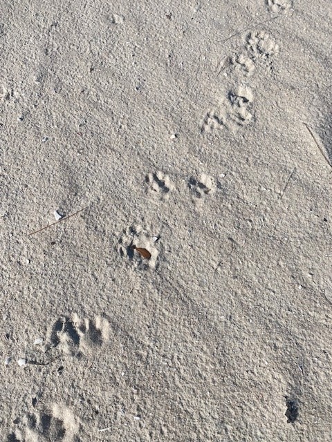
There was no wildlife on the beach that day but there were plenty of tracks. Mammals, even in the winter, still prefer to move around under the cover of darkness. I found the tracks of armadillo and raccoon, common mammals on our island, but there was another set that was harder to identify. The paw had the imprint of a cat (no claws visible) but the track was quite large for a feral cat. If it was, it was a big cat. I have seen bobcats in the Gulf Breeze area, and you cannot rule them out, but the pattern of the stride appeared more like an otter. Otter tracks would be webbed – these were not – so… I am not sure what it was.
Most encounter island mammals by finding their tracks.
Photo: Rick O’Connor
Leaving the beach, I returned to the inland trail heading back to the truck. On this portion of the trail, you cross over ponds just outside the walls of the fort. As I glanced across the water – hoping for a swimming snake – I saw something else. It surfaced briefly and then dove again. At first, I thought it was a diving bird, such as a cormorant or loon, but when it resurfaced, I saw that it was not. It was an otter. I had seen otters before in this area, and other pond areas on the island, but – like the bald eagle and dolphin – it is always exciting to see them again.
Based on this hike, it is still the time of the “warm-blooded”. Birds and mammals were the creatures most visible. We will see if this warming trend continues. Maybe during the late winter hike in March, we will see some of the “cold-bloods” come out. Maybe it WILL be an early spring.
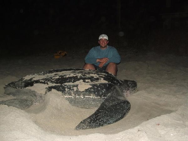
The leatherback sea turtle is the largest of the five species that have been found in the northern Gulf of Mexico. With a carapace (top shell) length between 6-7 feet and weighing between 800-1000 pounds it is truly a magnificent creature. Any encounter with them is amazing.
Most encounters occur with fishermen or divers who are out searching for artificial reefs to fish or dive. Though very rare, they have been known to nest in this area. They feed exclusively on jellyfish and will follow them close to shore if need be. But what do leatherbacks do with most of their time? Do they hang offshore and follow jellyfish in? Do they circle the entire Gulf of Mexico and we see them as they pass? Based on past studies, many encounters with this turtle occur in the warmer months. They often become entangled in commercial fishing longlines set in the central Gulf of Mexico. But what do they do during the fall and winter? One of the tagging projects presented at a recent workshop tried to answer that question.
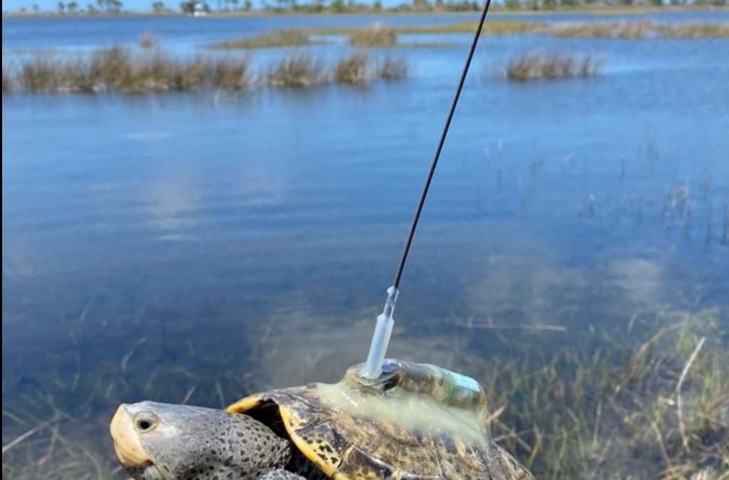
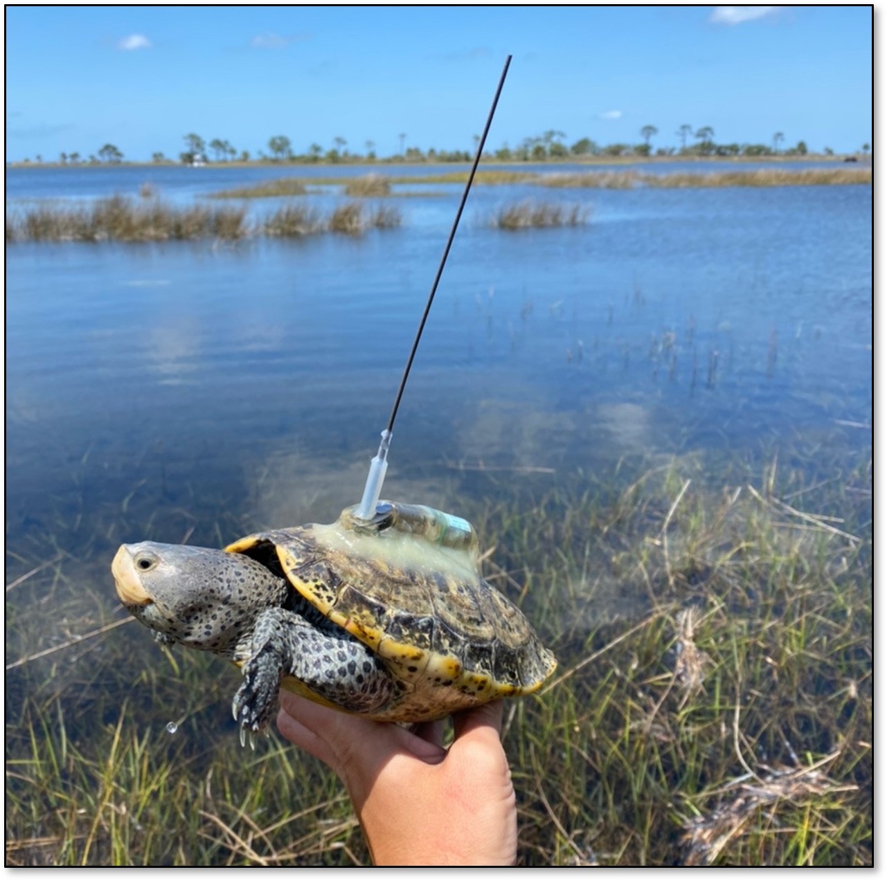
The project was led by Dr. Christopher Sasso of the National Oceanic and Atmospheric Administration. The tag chosen for this was a satellite tag. Since the leatherback must surface to breath air, and often is found near the surface following jellyfish, orbiting satellites would be able to follow them. As we mentioned in Part 1, catching the creature is step 1, and catching a six-foot 1000-pound sea turtle is no easy task.
The team used a spotter aircraft to locate the turtles. Once found, the pilot would radio the chase boat who would zip in with a large net. The net was connected to a large metal hoop and was designed to give way once it was around the turtle. Once in the net the turtle was hauled onto a small inflatable boat where the work of tagging could be done. They would measure the animal, take blood samples, place a PIT tag within them (similar to a microchip in your pet) and then attach the satellite tag by a tether to the tail end of the turtle before releasing it. The entire operation took less than 30 minutes.
Between 2015-2019 19 leatherbacks were tagged in the northern Gulf. 17 of these were females and 2 were males. Data obtained from these tags ranged between 63 and 247 days at liberty. The behavior the team noticed was divided into foraging behavior (feeding on jellyfish) and transiting behavior (direct swimming ignoring all).
The turtles foraged in this part of the Gulf until the fall season. At that point most of them moved south along the Florida shelf, past the western peninsula of the state, heading towards the Keys. A few chose to swim directly south against the Loop Current, and a small number remained in the area.
Those moving along the Florida shelf appeared to be foraging as they went. Those crossing the open Gulf may have foraged some but seemed to be focused on getting south to the nesting beaches. Almost all of the turtles entered the Caribbean on the east side of the Yucatan channel, following the currents, with their final destination being their nesting beaches. When they returned, they did so in the warmer months and used the western side of the channel – again following the currents – until they once again reached the northern Gulf and foraging began again. One interesting note from this study, the two males tagged did not leave the Gulf.
The tagging studies do show that leatherbacks use the Gulf of Mexico year-round. They usually head south to the Caribbean when it gets colder and use the currents to do so. It is during the warmer months we are most likely to see them here foraging on jellyfish. It is an amazing experience to encounter one of these large turtles. I hope you get to experience it one day.
Satellite tracks of leatherback movement in the GoM. Red (2015), Blue (2018), Black (2019).
Image: Sasso (et.al.) 2021.
Reference
Sasso, C.R., Richards, P.M., Benson, S.R., Judge, M., Putman, N.F., Snodgrass, D., Stacy, B.A. 2021. Leatherback Sea Turtles in the Eastern Gulf of Mexico: Foraging and Migration Behavior During the Autumn and Winter. Frontiers in Marine Science., Vol. 8., https://doi.org/10.3389/fmars.2021.660798.
Recently I attended a workshop on wildlife tagging projects. Researchers from across the Gulf of Mexico who had projects going on in the northern Gulf were invited to present their updates. I was there to help present what we have learned about diamondback terrapins but there were numerous other talks, and the results were fascinating. Fascinating enough that I thought the public would be interested in them as well. Most of the presentations were on fish or reptiles, but the fish included interesting species such as whale sharks, tiger sharks, cobia, and tarpon. So, I am going to run a series of posts on the different species along with another series on barrier island wildlife.
I thought I would start with an introduction on the methods of wildlife tagging and why scientists tag animals. Some of the reasons may seem obvious, but with today’s modern tags, there is a lot of information scientists can gain from doing this.
Why do they tag?
With the types of tags they used when I was in school there were a few things that you could learn. (1) How far do the animals range, (2) how fast they reached those locations, (3) some idea of live longevity – you at least knew how long they were “at freedom”. With these data you could get a better idea of what their habitat range was and how they used the habitat. Some, like blue sharks, may move great distances all year long. Others, like nurse sharks, may not move more than a few miles from the point where they were tagged. Others may move seasonally, spending summer in one region and winter in another. All of these data are useful to resource managers responsible for maintaining the species population.
With the more modern electronic tags, they can learn such things as how deep they dive, how long they stay at depth, what water temperatures they may frequent, what salinity they prefer, and let you know where the animal is at any given moment in time. Today’s tags are pretty amazing.
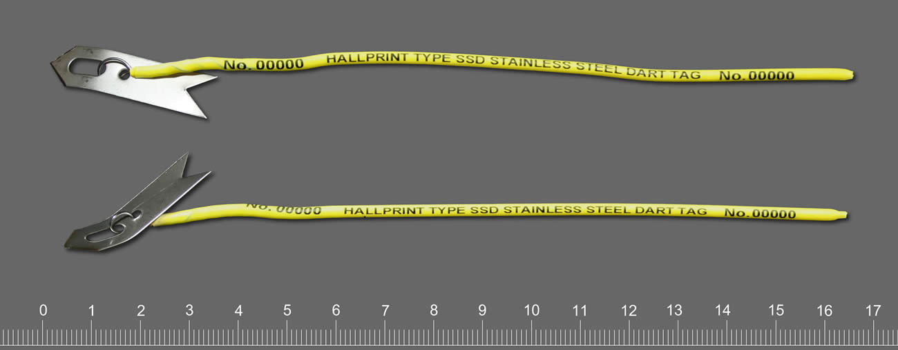
This tag is similar to the ones we used in the 1980s on sharks. They provide a number for individual identification. Ours also had a capsule with a note on water resistant paper.
Photo: Hallprint.
How do they tag?
Well… step one to answering this question is HOW DO YOU CATCH THE ANIMAL? – not as easy as you think. Whale sharks and leatherback sea turtles are quite a handful. If your target species is something like a white shark, tiger shark, diamondback rattlesnake, there is an extra danger added. As you plan a method for your safety, you must also plan a method for their safety. The objective is not harm or kill the creature – you will learn nothing from this. When I began my career, I saw a program on how they tagged polar bears in the 1980s. They would fly over the ice in a helicopter looking for the bears. When the bears saw the helicopter, they would run for the safety of water. The scientist would try to shoot a dart into the animal to put it asleep long enough to get a tag on it. BUT if you overdosed the bear, and it made it to the water, it could drown. So, from the air, they had to gauge the weight of the bear, guess what amount of the drug to shoot, and hope they were right. If the bear did fall asleep, how “asleep was it? Did you give ENOUGH drug? Polar bears can be very dangerous. In the episode I watched the bear was asleep, but the researchers did mention that they will “play sleep” and you need to be ready. Such was the world of wildlife tagging 40 years ago.
One of the things that was also discussed when I was in school was what type of tag you were going to place on the animal. They did not have the neat tools they have now. Most tags had a capsule with a piece of paper, sometimes written in multiple languages, to call said person and report where and when they found the animal. There was usually a monetary award for doing so, or sometimes a hat or T-shirt. I remember the hat you got for reporting a tagged redfish was really neat, but I never caught a tagged one.
You did not want to place a tag that would alter the natural behavior of the animal. In the case of the polar bear, they would place an ear tag and paint a large number on its side in black paint. This made sense from the biologist’s side – flying over the ice you could see the large black “3” on a bear and know the individual. But that large black number could also be seen by their prey. Not good. I saw researchers painting the shells of gopher tortoises with all sorts of neon colors to make detection by them easier, but easier for their predators as well.
Radio tagging was used 40 years ago. This involves capturing the animal (as we have already seen – fun in itself), putting it asleep and attaching/inserting a radio tag. This tag provides a radio signal that can be detected by a receiver carried by the research holding an antenna walking/driving around following the animal. You had to be within range to hear the signal and – honestly – good at detecting the signal. Some researchers were better at this than others. As you can imagine this was only as good as your ability to keep up with the animal. At some point your car/boat would need fuel, or the animal crossed a river you could not. It provided some good data, but there were limits.
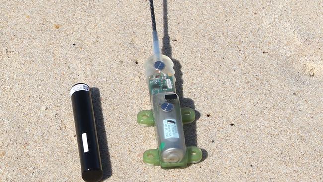
Today modern tags have solved a lot of these issues. Some new tags do not have typed notes but sensors that can detect the elevation/depth, temperature/salinity, all sorts of information that was unknown in my college days. These tags can be retrieved and downloaded on a computer to give a much better idea of how the animal spends its time and what it seeks.
This modern shark tag could provide additional information such as diving depth, water temperature, and more.
Satellite tags work well for creatures who surface frequently – sea turtles, whales, whale sharks. Satellites can detect them, and you can follow their movements/habitat preferences as they are actually using them.
For species at depth, like some sharks, cobia, tarpon, etc. there are now acoustic tags. The tag emits a signal that is detected by an array of receivers the researchers place in the environment. As the animal passes within range of the receiver it is detected, and the downloaded data gives a similar picture of how the animal uses the environment. A couple of neat things about acoustic tags are that (a) you can track satellite tagged animals while they are diving, and (b) your receivers can detect other species tagged by other researchers and let them know where their creature was. This was one reason for the workshop – so, everyone could meet everyone else and know who has tagged what and how to share information.
No tag is permanent. All are designed to fall off. Battery power will eventually fail. But no animal is stuck with this all of their lives as they could have been when I was in school. In future articles we will look at the results of some of these studies.
This tag with an antenna can be detected by a satellite and tracked real time.
Photo: USGS
I am sure everyone has noticed how cold this winter has been. We have had multiple days in the 20’s here in the Florida panhandle, even some snow flurries near Pensacola. I was first told this may happen by a Sea Grant colleague of mine who works with oyster farmers. Six months ago, he said the Farmer’s Almanac mentioned this would be a colder than normal winter. A few weeks later a Master Naturalist mentioned that if it was heavy “mast season” (lots of acorns on the ground) it would be a colder winter. We certainly had a heavy mast season in Pensacola this year, acorns were EVERYWHERE. And here we are. As I type this it is 27°F outside.
Though we do not see snow as often as Colorado, the panhandle does see snow from time to time.
Photo: Rick O’Connor
This past week I was at a Sea Grant meeting. We were discussing this cold and another colleague mentioned that it was an El Nino year. That’s right… it is an El Nino year, and many know that the weather does change when this occurs.
I first heard of the El Nino shortly after receiving my bachelor’s degree. I was teaching at Dauphin Island Sea Lab, and we had a video series on oceanography and one episode discussed it. It explained that commercial fishermen in Peru were the first to notice it over a century ago.
Off Peru’s coast is a large ocean current that originates in the Antarctic, flows north towards the equator passing the west coast of South America along the way. The water is cold and full of life. The Andes Mountains also run north-south along the coast. Cold air at the top of the mountains runs down towards the coast and offshore. As it blows offshore, it “pushes” the surface water of the ocean offshore as well. This generates an upwelling current moving from the ocean floor towards the surface, bringing with it nutrients from the sediments below. This nutrient reach seawater, mixing with the highly oxygenated cold water, and the sun at the surface creates the perfect environment for a plankton bloom, and a large bloom she is. This large bloom attracts many plankton feeding organisms, including the commercially sought after anchovies and sardines. This in turn supports the tuna fishery that comes to feed on the small fish. These are some of the most productive fisheries on the planet.
Based on records kept by Peruvian fishermen, every three to seven years the surface waters would warm, and the fish would go away. It was lean times for them. When it did occur, it would do so around Christmas time. So, the fishermen referred to it as the El Nino – “the child”.
Based on the video episode we showed the students, others began to notice warming along the western Pacific and realized it was a not a local event, but a global one. A high school friend of mine does sound for nature films and one of his first projects was to video the effects of the El Nino on the seal nesting season in California. As in Peru, the cold waters become warm, the bloom slows and the fish go away, with less fish the mother seals have no food so, cannot produce milk for their newborns waiting on the beach. As horrible as it sounds, and was to watch in Mike’s film, the mothers eventually abandon the newborns to starve.
The video we showed at Sea Lab followed marine biologists studying corals along the western coast of Central America. Here the waters were warming as well, warmer than normal, and the corals were stressed and dying. With orbiting satellites now in place oceanographers were able to view this event from space and watch the entire thing unfold. These images showed that during a normal year the western Pacific had cold water along California and much of South America. The waters along western Central America were warm. But during an El Nino year, warm water replaced the cold, particularly near Peru. Scientists were able to connect several events to El Nino seasons. Increases in wildfires in the western US, people were viewing the northern lights at lower latitudes, droughts occurred where it was usually wet, floods occurred where it was usually dry, and during one El Nino season the Atlanta Falcons made it to the NFL playoffs. Weird things were happening.
The obvious question for science is what drives these El Nino events?
It is understood that our weather and climate are driven by ocean currents. The “dry air” everyone talks about in the western US is driven by the cold California Current. Likewise, the “humid air” of the southeastern US is driven by the warm Gulf Stream. If you alter these currents, you alter the weather and climate of the region. How do you alter ocean currents?
Warm water in the eastern Pacific indicates an El Nino season.
Graphic: NOAA
In the 1980s, when I was teaching at Dauphin Island Sea Lab, the video suggested a connection to sunspots on the surface of the sun. At the time, they were not sure whether the increased sunspot activity triggered the El Nino, or whether there was something else going on, but there was a correlation between the two.
One explanation comes from a textbook on oceanography I used when I was teaching marine science during the 1990s1. It explains the event as such…
During “normal years” cold water from the Arctic and Antarctic runs along the western coasts of North and South America – both heading towards the equator. Once there, the earth’ rotation moves this water westward towards Australia and Indonesia, warming the water as it goes.
Apparently, the ocean currents cannot transport and disperse these warm waters effectively once they reach the western Pacific. Thus, warm water begins to build there.
This accumulating warm water seems to reverse the trade winds that normally flow from the eastern Pacific to the western along the equator. This wind reversal occurs between November and April. It mentions that in the late 1990s the cause of this wind reversal was not well understood.
This wind reversal is often followed by the development of twin “super typhoons” (very strong typhoons) north and south of the equator.
The extreme warm water in the western Pacific affects the weather in the region and this “heat mass” expands spatially. During this expansion, the high-pressure system that sits over the eastern Pacific, bringing them the dry air we know California for, weakens. At the same time, the normal low-pressure system over the western Pacific weakens and, in a sense, things are flipped. This atmospheric change is called the Southern Oscillation, and the entire event was termed the El Nino Southern Oscillation (ENSO).
The power of the typhoons moves warm water from the western Pacific across the equator to the America’s. The waters there warm and the historic El Nino occurs. This movement takes several months.
The El Nino will persist for one to two years. When the warm water eventually releases its heat, the waters cool, and normal conditions return. Until the next El Nino forms.
In the 1990s they had already noticed an increase in the frequency of El Ninos (based on old fishermen’s logs). They suggest climate change may be driving this.
During El Nino years weather patterns change globally, as mentioned above. This altering of the weather impacts all sorts of biological processes, as mentioned above.
Often, the “return” of colder water along the western Pacific “overshoots” normal temperatures and the ocean becomes colder than normal. This has been termed the La Nina.
I kind of imagine the whole process like a sloshing pool of water flowing towards one end of the pool, bouncing off and sloshing back to the other. But instead of water “sloshing around” it is temperatures.
But this was 1996. Have scientists learned anymore about this event?
Not much has changed in their explanation, other than we are much better at predicting when they will happen and alert the public so that farmers, fishermen, fire fighters, etc. are prepared. They do seem to be increasing in frequency.
For the 2024 El Nino, which NOAA began alerting the public in the summer of 2023, they are predicting it to continue for several seasons2. There is no doubt that this winter is colder than normal. The Florida panhandle also experienced a drought this past fall. But… during most El Nino years, hurricanes are few in the Gulf of Mexico. We will see, and watch, how the rest of the year rolls out.
Reference
1 Gross, M.G., Gross, E. 1996. Oceanography; A View of Earth. 7th edition. Prentice Hall. Upper Saddle River, New Jersey. Pp 472.
2 El Nino / Southern Oscillation (ENSO) Diagnostic Discussion. Jan 11, 2024. National Weather Service Climate Prediction Center. National Oceanic and Atmospheric Association.