When visiting and exploring seagrass beds, most are hoping, and expecting, to see fish. As we have seen in this series, there are a lot of creatures that can be found living within a seagrass meadow, but it is the fish that get our attention and what we talk most about afterwards.
According to Hoese and Moore’s Fishes of the Gulf of Mexico; Texas, Louisiana, and Adjacent Waters, there are 497 species of fish found in the Gulf of Mexico. In my surveys of Pensacola Bay over the years, I have logged 101 of those in the estuary. I am sure there are more, but I can confirm there are at least those. Many spend all or part of their time in our seagrasses. As you seine or snorkel in the grassbeds you will notice most of them are very small. Much of this is due to the fact that the seagrasses are nursery areas for many species, and it is the young that we find here. But many are also small as adults, and the grass provides food and shelter for them. There are far too many to mention in an article like this, but let’s look at some of them.
Sardines and Anchovies
As you snorkel through the grass, or even look at it from a boat or dock, you see numerous silver colored baitfish flashing as they dart in and out of the grass. There are all sorts of silver baitfish in the seagrasses with sardines and anchovies being two of them. In my experience seining for fish, they appear to be seasonal. I did not capture them all year but when I did, I would capture a lot. These species are famous for being the ones in small tins that people consume, though there is no fishery for them here locally. Anchovies have also been considered an indicator species; their presence suggests good water quality.
The striped anchovy is a fish often found in our seagrass beds.
Photo: NOAA.
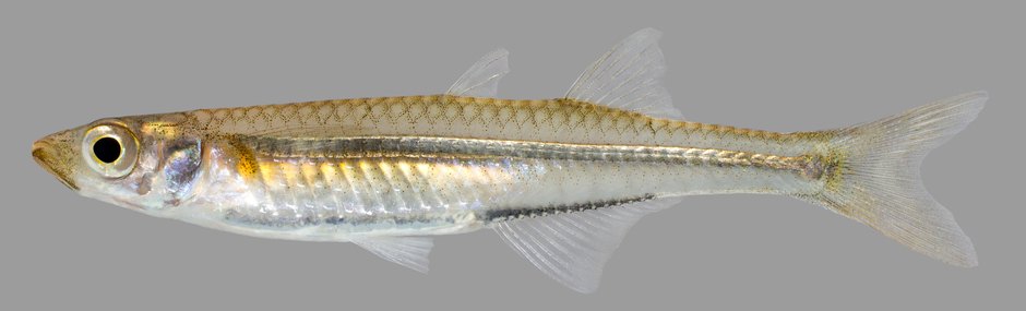
Silverside Minnows
Also known as silversides and glass minnows, these are one of the most common fish collected in seine nets. They are abundant year-round and are an important food source for many of the larger predators living here. Small and transparent, you do not see them while snorkeling. Their huge presence is only discovered when you pull a seine net through the grass. There are several species of them, but they are not easily identified and more often are just logged as “silversides”. They are an important member of the seagrass community.
The silverside, or “glass” minnow.
Photo: U.S. Geological Survey
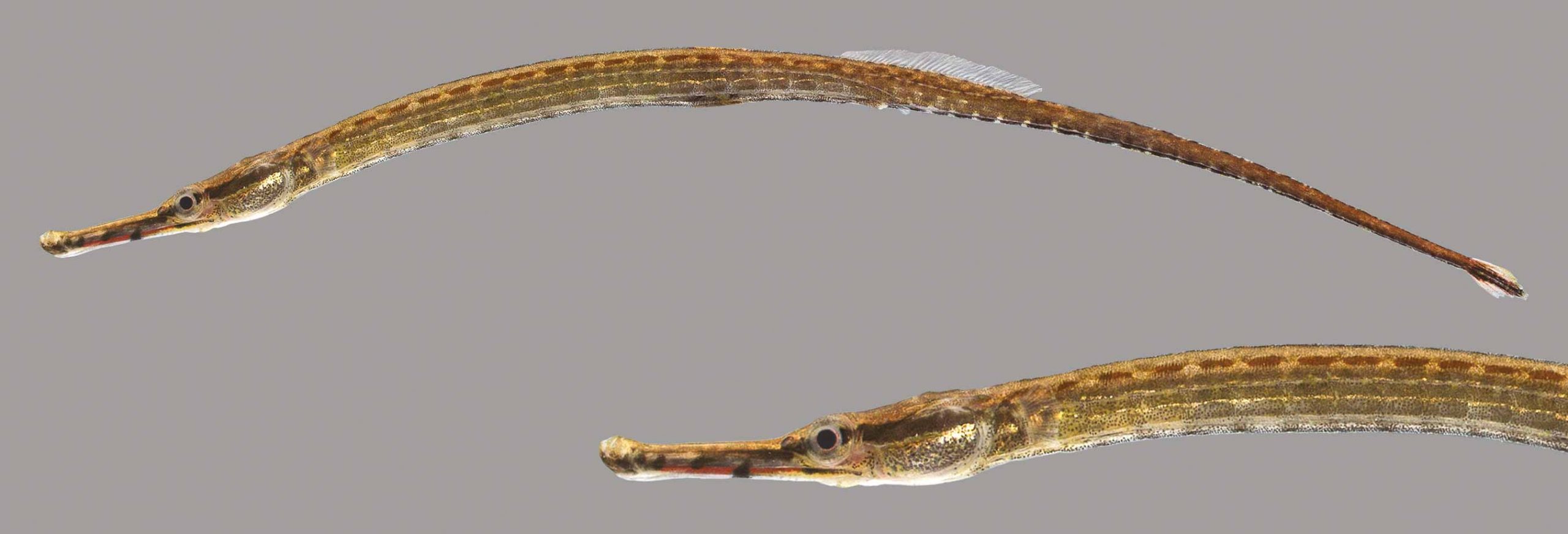
Seahorses and Pipefish
These two fish are highly specialized for living in seagrasses. They look like grass and move very little making them hard to detect. Like silverside minnows, it is rare to see them while snorkeling but make their presence known when seining. Their bodies are covered in armor-like scales, and they have tubed mouths for “vacuuming” small invertebrates from the water column. They are very slow swimmers and have to avoid detection by blending in with the environment. And yes, it is the males that carry the eggs in their brood pouches. These are amazing fish and always bring excitement when they are captured in the net. There are two species of seahorses and seven species of pipefish found in our waters.
The seahorse-like pipefish.
Photo: University of Florida
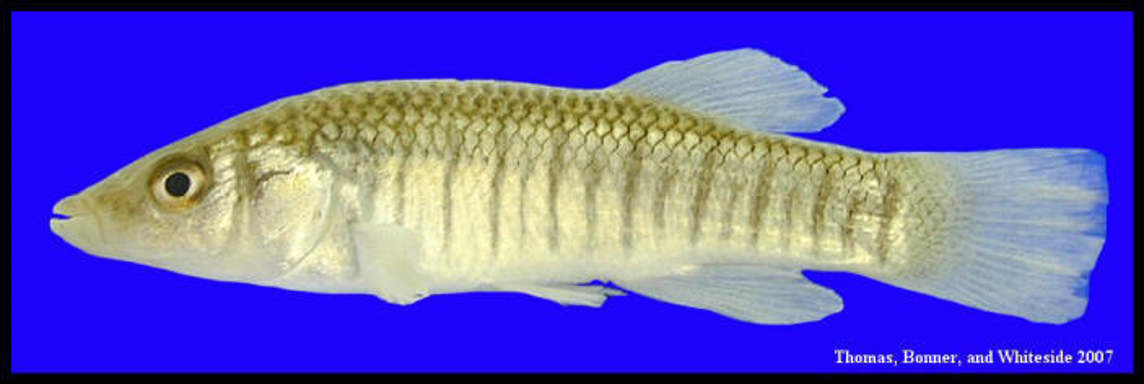
Killifish
Often called “bull minnows” by anglers, these small fish are, at times, very abundant. There are seven species of killifish in our bays but the Gulf Killifish, Longnose Killifish, and the Bayou Killifish are the ones we most often collected.
This longnose killifish has the rounded fins of a bottom dwelling fish.
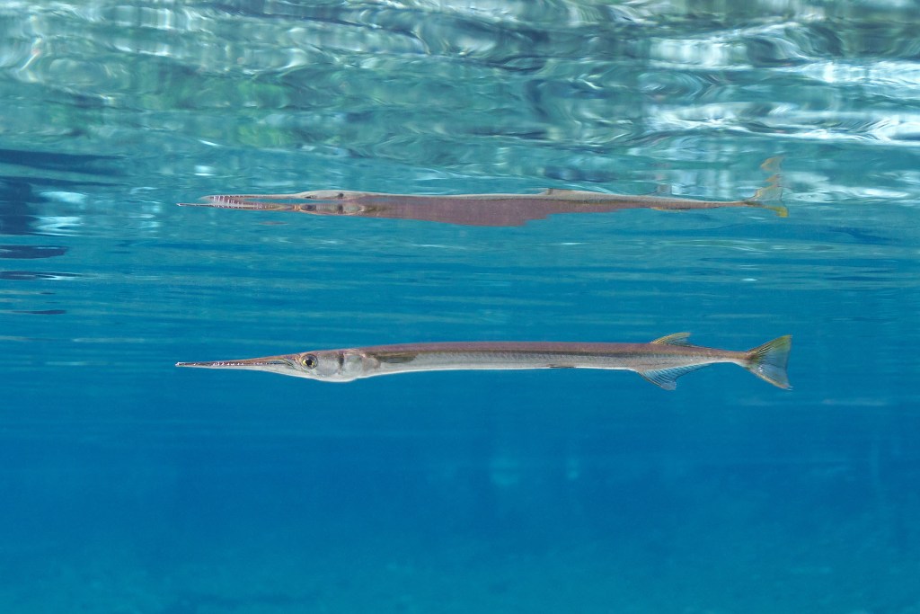
Needlefish
These are common, frequently seen, fish swimming at the surface of the water. Long and needle-shaped, these fish have long snouts full of sharp teeth indicating they are one of the predators of this system. There are four species of them, and they are not easy to tell apart. They are harmless to humans unless you capture them in your net at which time they will try to bite.
Swimming near the surface is a common place to find needlefish.
Photo: Florida Springs Institute
Mullet
Another very common fish found year-round here. This species are the ones famous for jumping while you are fishing, paddling, or just watching from the beach. Those who do not visit the Gulf coast often always ask “I just saw a fish jump!” and the reply from a local (without even looking up to see what it was) will reply “It’s a mullet”. These schooling fish can get pretty large (average length is 30 inches) and it is common to see fishermen out with their cast nets trying to catch a few. It is a popular food fish for those along the Gulf coast. Mullet fries, with beans and grits, are a way of life here. The fish are easily seen swimming and darting over the grass as you paddle by, and their young are found seasonally in seine nets. They are bottom feeders, feeding mostly on algae from the grass blades. There are actually two species, the white and the striped mullet. The striped mullet, also known as the black mullet, is the one most often sold in the seafood markets.
The Striped Mullet.
Image: LSU Extension
Drums and Croakers
With 18 species within this family, this is the largest family of inshore fish in the Gulf. Growing up along the panhandle people learn quickly about croakers. Back in the day when gill nets were used to harvest mullet, croakers were a common catch as well, and often consumed. Today they are still sought by some shore-based anglers and juveniles are common in seine nets. The species I most often captured were the spot and Atlantic croaker. Spot croakers were common year-round, Atlantic croakers were more seasonal.
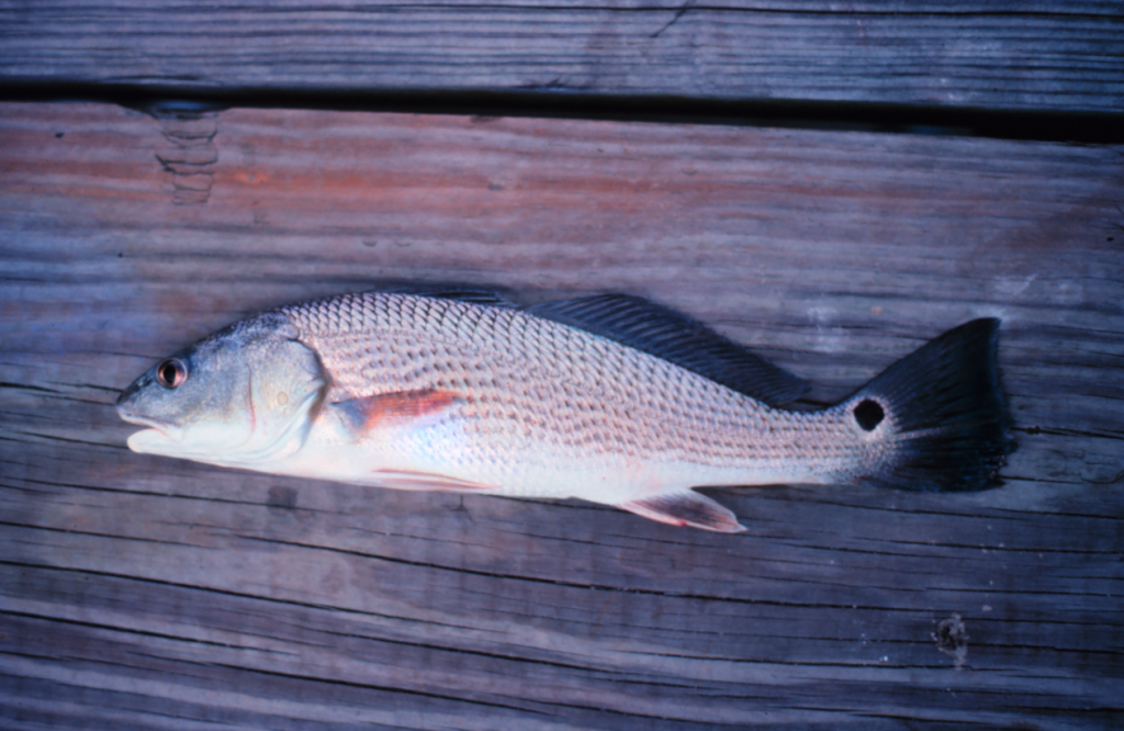
Drums are larger members of this family. There are several species more associated with sandy bottoms and the shoreline of the Gulf, many of these are called whiting, but the red drum (redfish) and black drum can be found in the grassbeds. Redfish are particularly common here and one of the reasons many anglers get out of bed in the morning. They are very popular sportfish across the region. Black drums are not found as often, and like being around pilings and structures that offer certain foods they prefer. Both species can get quite large. Redfish average 5 feet while black drums can reach an average of 3 feet.
All of the fish in this family are famous for their “croaking” “drum” sounds they make using their swim bladder, and it is rare not to capture at least one kind in a seine net.
The classic look of a bottom fish. This is the redfish, or red drum.
Photo: NOAA
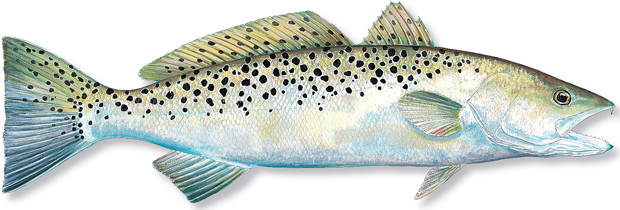
Spotted Seatrout; Speckled Trout; “Specks”
There is no “trout family” in the fish world. Most freshwater trout are members of the salmon family while the marine versions are members of the drum/croaker family. This is the case with the famous speckled trout – or speck. There are white trout and silver seatrout in this family, and all are sought after by anglers, but it is the speckled trout that is most associated with seagrasses, most sought after by anglers, and is one of the top predators in this system. They reach an average length of 4 feet.
From my experience both snorkeling and seining the grasses, I would say – hands down – that pinfish is the most common species found in our grasses. For many young anglers this is the first fish they ever catch. You can see them easily while snorkeling and they are the most numerous species in the nets throughout the year. Their huge numbers play an important role in the food web of this system. Feeding on a variety of small invertebrates in and around the grass blades, pinfish are a large part of the diet of the larger sportfish we target. Throwing cast nets and dropping pinfish traps is popular with anglers to collect this abundant baitfish for their life bait fishing efforts. They are called pinfish because of the sharp spines in their dorsal fins. These are also the fish that nip at your ankles while you are standing still in the water.
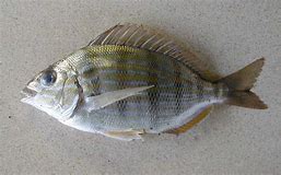
Sheepsheads are larger members of the porgy family (the ones these two species belong to). As adults sheepsheads prefer hard structure where they can use their incisors to chip away at barnacles and other shellfish, but they are sometimes found roaming the grassbeds and their young will spend their growing years hiding and feeding in the grass.
One of the most common fish in our grassbeds; the pinfish.
Photo: Nicholls State University.
Pigfish
When first captured in the seine net, pigfish are often confused with pinfish – they look very similar. But a closer look at the striping/spotted pattern on their sides, and the position of their mouth, you realize you have something different. Being members of the grunt family, they also “croak” like croakers and drums – hence their common name “pigfish” – due to the grunting sounds. This helps with identifying which fish you have. Though common in the grasses, I did not catch these as frequently as pinfish and they were not as abundant.
Spotfin Mojarra
This is a common silver baitfish that resembles the pinfish and is frequently collected in our seine nets. The mojarra is in a different family than pinfish. They lack sharp spines and incisor teeth, rather they have a sort of “vacuum” like mouth which they use to suck small invertebrates from the sand.
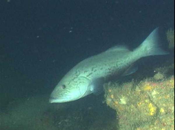
Gag Grouper
This is a popular sport and commercial fish from the wrecks and reefs of the Gulf of Mexico. But gags begin their lives in the seagrass beds, and we have collected medium sized individuals in our seine nets. This underscores the importance of these grassbeds to the fisheries so many love. We need to protect these systems from our activity both on land and in the water.
Gag grouper.
Photo: National Oceanic and Atmospheric Administration
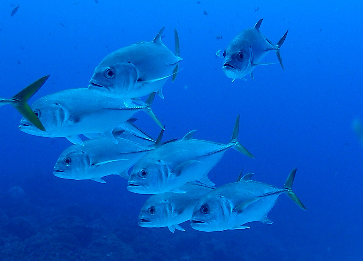
Jacks
Another popular group with anglers, many species of jacks use these grasses as their nurseries. We most often collected juvenile lookdowns, pompano, and crevalle in our nets. At times we caught a small member of the family called a leatherjacket. These were seasonal and associated with breeding. Once again, underscoring the importance of having healthy seagrasses.
Jacks have the sleek, fast design of the typical open water marine fish.
Photo: NOAA
Toadfish
One of the creeper looking fish in the seagrass community is the Gulf toadfish (also known as the oyster dog). This monstrous looking bottom fish lives in burrows scattered around the grassbeds where they lie in wait to ambush prey. Their large mouths and sharp teeth can grab a variety of creatures, including the human finger. At times small toadfish will move into an empty can or bottle discarded by people instead of a burrow where they grow to a size they can no longer escape. It is said there may be a mild venom associated with their bite. Though no one has ever died, or been sent to the hospital, due their bite, it is painful and should be avoided.
The common estuarine Gulf toadfish.
Photo: Flickr
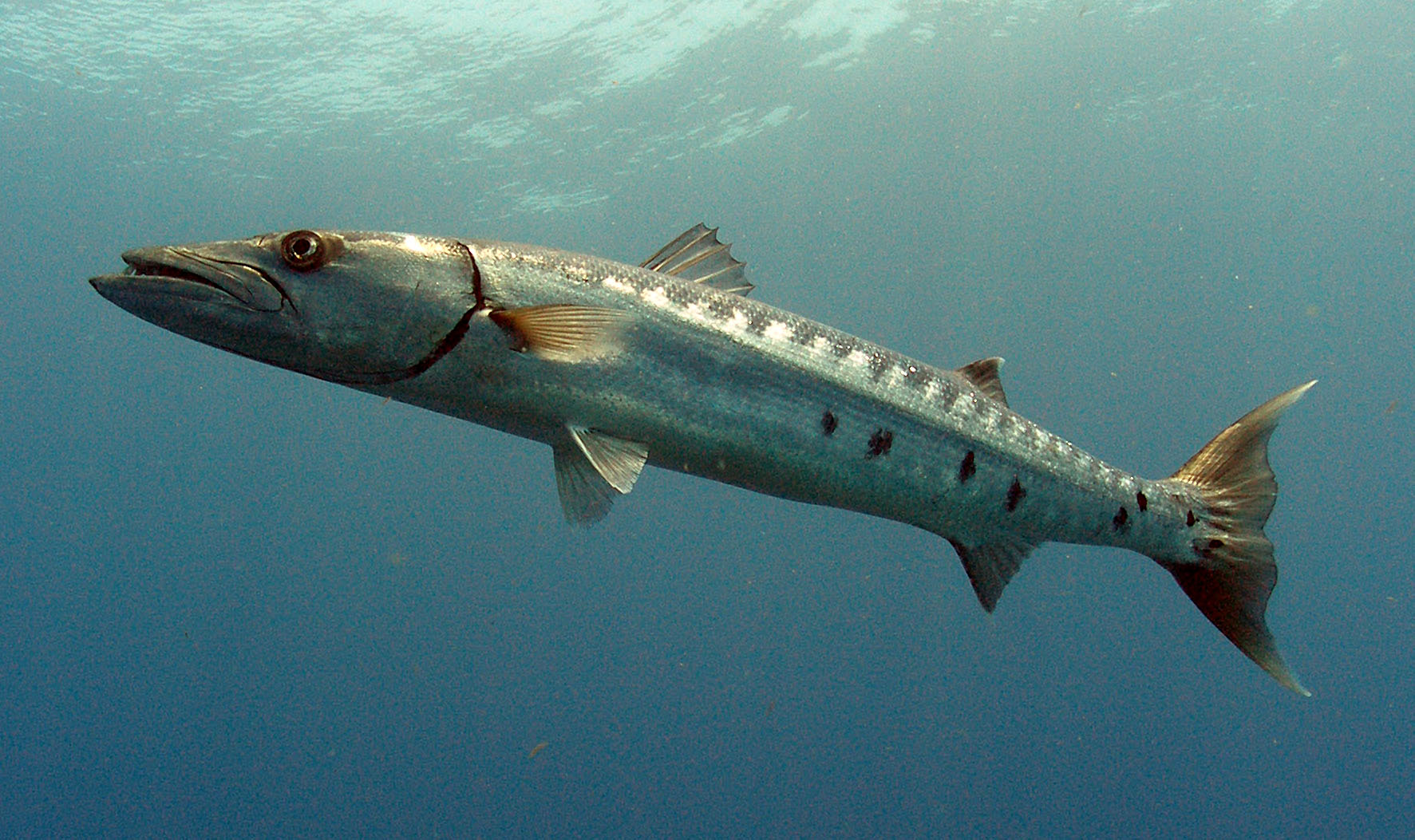
Barracuda
Yes, barracuda can be found in seagrasses. But in our case, these have all been juveniles. There are three species of them, and they are not easy to tell apart. They also appeared to be seasonal in our collections. We never found them high numbers, usually one or two in a seine. But they are present.
The Great Barracuda. Photo: NOAA
Lizardfish
This is another medium sized, sharp toothed, bottom dwelling predator of the grassbed community. There are seven species of them, and all have that “snake” “lizard” look to them having many sharp canine teeth. They spend their time buried in the sand waiting to ambush potential prey. Snorkelers may see them as they dart away tossing up sand when we get too close. I rarely see them snorkeling but occasionally capture them in the seine net to the delight of the students assisting.
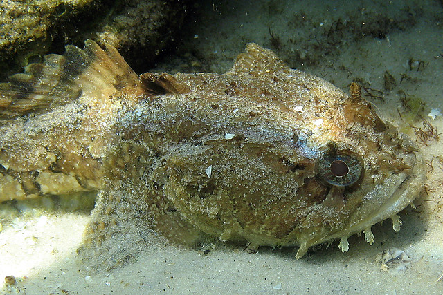
Blennies and Gobies
These are very small fish that are almost impossible to find while snorkeling but are often collected in the seine net. They resemble the freshwater darters and, lacking a swim bladder, spend their time on the bottom. There are many species associated with rocks and artificial reefs but there are some who call the seagrasses home. They use their incisor teeth to feed on small invertebrates in and on the grasses. Being territorial, they can give a little nip to your hand. Gobies differ from blennies in that their two pelvic fins are fused together to form a sort of “cup” or “sucker disk”.
Puffers
Another one of the more popular fish with students who help me seine. Everyone loves to see them inflate with either water or air into a “balloon” to make it very difficult for predators to consume them. There are eight species of puffers in the Gulf of Mexico, five of them have been captured in our seines. Most are small with little “bumps” on their bodies instead of spines. But there is the Burrfish, who is a member of a different family that is medium sized, has spines, and is very common in the grassbeds.
Striped Burrfish
Photo: NOAA
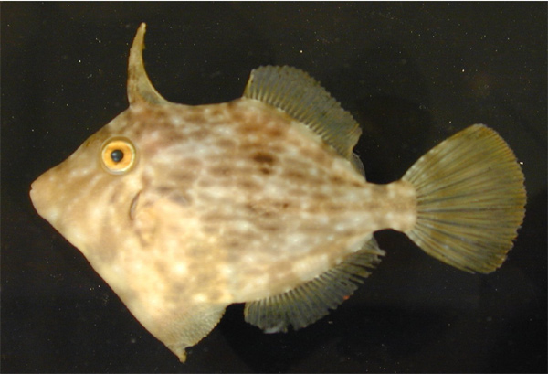
Filefish
Our grassbeds are full of a small cousin to the triggerfish – the planehead filefish. Like triggerfish, filefish have a thick sharp spine that is found at the front of the dorsal fin – called a “trigger” on the triggerfish. The planehead filefish is a small species (nine inches average length), green to brown in color, and very common in the grassbeds; though you will probably not see one unless you catch it in a net.
Planehead Filefish.
Photo: NOAA.
Flounders and Soles
A favorite food fish for many locals, flounders spend a lot of time buried in the sand near grassbeds to ambush prey. Born with a typical fish design, early in development one of their eyes will move to the other side of the head, giving them two eyes on one side. By doing this, they have increased their binocular vision, improving their ability to judge accurate distance of the prey, and making hunting easier. They lose color on the side where the eye has left and have chromatophores (cells) on the side where the eyes are that, like octopus and squid, allow them to change colors and blend in. In our part of the Gulf, if the eyes move to the left side of the head, they are called flounders. If they move to the right, they are called soles. Soles in our part of the Gulf of small not of much interest to anglers. One small species is often collected by shrimpers who feed them to hogs. This sole can “cup” their body in defense making like a suction cup and they do this in the throat of the hogs sometimes killing them. They are called “hogchokers”. Flounders on the other hand are very popular with anglers. Some fish for them using rod and reel, others prefer gigging them at night using lanterns. There are 17 species of flounder, some reaching lengths of three feet.
A flounder scurrying across the seafoor.
Photo: NOAA
Tonguefish
Tonguefish are small flat fish with eyes on one side of their heads like flounder. They differ than that their tails come to a point and there is no caudal fin present, as there is in flounders. As mentioned, they are small – ranging from 3 to 8 inches in length. The Blackcheek tonguefish is particularly common in our grassbeds. But like so many, you will not see it unless you catch it in a net.
Snook
This is a very popular gamefish from south Florida associated with several habitats including grassbeds. Due to a process some call “tropicalization” – the movement of tropical species north due to climate change – snook are now, albeit in small numbers, reported in the Florida panhandle. This is a new species you may see while exploring or fishing out there.
This snook was captured near Cedar Key. These tropical fish are becoming more common in the northern Gulf of Mexico.
Photo: UF IFAS
There are many more species of fish found in our grassbeds we could talk about, but we will end it here. As we mentioned in the beginning, this is a group of animals that many come to the beach to find. Whether for fun or for food, finding fish makes for a good day. See how many different species you can find.
In 1973 the United States Congress passed the Endangered Species Act. Controversial at the time, and still is today, the law was designed to help protect, and possibly restore, species that were near extinction within the boundaries of the United States. At the time there was a lot of concern about what was happening to whale populations across the world. These majestic creatures were being hunted by humans for food and other products. The hunt had been going on for centuries but in the mid-20th century it moved to an industrial scale and many populations were on the verge of extinction. The backlash from many around the world was enough for regulators in the United States to take notice.
In the 1970s there was an estimated 1000 manatees in Florida. These animals suffered from the increase of humans in their environment altering the habitat and literally running over them with an increase in boating traffic. Many growing up in Pensacola at the time had never seen a brown pelican and had never heard of an osprey. And then there was the decline of our national symbol – the bald eagle, and other national icons like the bison, bears, alligators, and moose. The loss of wildlife was noticeable.
At the time, if you looked at what was happening from the “30,000 foot” level, you could see the impact. Our barriers islands, which supported dunes that reached 40-50 feet tall, were being cleared at an alarming rate. Being replaced by large concrete structures, parking lots, and amusement parks. This loss of habitat forced the decline of the diversity and abundance of wildlife and the carrying capacity of supported populations declined.
If you looked seaward into the Gulf of Mexico, you saw a change from smaller boats with 75-100 horsepower motors to large vessels with up to four 350 horsepower motors on each boat. The number of these vessels seeking fish increased from hundreds to thousands, to even tens of thousands in some locations. Just visit one of the passes into the Gulf one weekend and you will witness the number of fishing vessels heading out. These boats were heading to fishing sites that at one time supported a species’ carrying capacity that was high and could certainly sustain the human need for food. Today these systems are stressed due to overharvesting.
If you looked towards the estuary, you saw the increase growth on the island produce runoff that made the waters more turbid, creating conditions that stressed many species of fish, invertebrates, and plants. Most notably was the loss of seagrass, which supports at least 80% of the economically important finfish and shellfish we seek. We removed coastal salt marshes, which also support fisheries, and replaced them with piers, docks, seawalls, and manicured lawns. These alterations again supported the decline of needed habitat and the diversity and abundance of coastal species. Creatures that were once common in many locations like horseshoe crabs, blue crabs, and echninoderms were now hard to find in some bays. The prized bay scallop is all but gone in many locations along with the recreational fishery that loved them.
On the mainland side of the estuary, you find the large cities. These are the locations that both the early European colonists and the Native Americans sought. They were at the connection between the freshwater rivers and estuarine habitats that supported their way of life. In the mid-20th century, these communities witnessed massive growth of humans. These humans cleared land, built concrete buildings and roads, decreased suitable habitat for much of the life that existed there, and increased pollution in both the ground and surface waters. Oyster beds began to decline, seagrasses that had reached the upper portions of the bay declined, and salt marshes were removed for a different sort of waterfront.
Much of this had been noticed even in the 1960s. The species that spawned the Endangered Species Act were mostly the large vertebrates that people felt close to, or the need for. Species such as whales, dolphins, manatees, and sea turtles. People were concerned about species like bison, moose, and pelicans. But, as the draft of the law was formed, it included others that were not on their radars like alligators, frogs, and sturgeon. The focus of the effort was the large vertebrates we were concerned about. However, there were numerous small creatures that were being lost that became part of the movement such as river mussels, snails, even beach mice. Then there were the numerous small creatures that will still do not know about.
For decades scientists have written about the world of the tiny creatures that live within the sand grains, and on the surface of seagrass that play crucial roles in the over health of the ecosystem and support, directly or indirectly, the larger creatures we care about. Even with the decision as to which species would be listed as “endangered” we saw favoritism for the large vertebrates that we appreciate. When placed up for listing consideration species like spiders, sharks, and snakes were met with resistance. Though their populations may have needed this protection, we did not want to protect those.
Despite some opposition from the beginning, the Endangered Species Act has had many success stories. Several species of whales are now stable or increasing, manatee populations have more than doubled, pelicans are common, everyone knows what an osprey is now, and viewing a bald eagle in Pensacola – though still exciting – is becoming more common place. Another sign of success are species that have been de-listed from endangered to threatened or removed completely. Alligators, bison, manatees, several species of sea turtles, and even the bald eagle have had this honor.
Over the next few months, we will post articles about species that benefitted from the Endangered Species Act, and species who are still struggling and should benefit from it now. There is no doubt that some humans suffered economically with the passing of this law, but its intent of preserving, and increasing the fish, wildlife, and even plants – that we love and need, as worked.
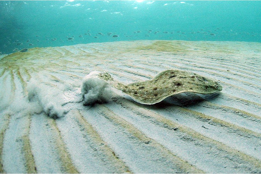
As I write this article it is mid spring, and the rays are bedding on the edges of our seagrass beds. The most common species seen is the Atlantic Stingray (Dasyatis sabina). They are often found in the sandy areas near the grass where they bury in the sand to ambush potential prey. This time of year, their numbers increase as the females are preparing to releasee their young in summer. Mating occurs in early spring and the females will deliver live young1.
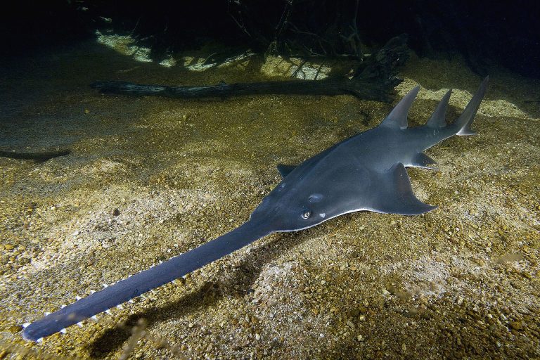
According to Hoese and Moore2, there are eight families and 18 species of rays and skates found in the Gulf of Mexico. These are cartilaginous fish found in the same class as sharks but differ in that their gills slits are on the ventral side (bottom) of the body and their pectoral fins begin before the gill slits do on the side of the head. Most are depressed (top to bottom) and appear like pancakes, but not all of them. Sawfish and guitarfish appear more like sharks than rays.
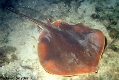
Of the 18 species listed, seven can be found in the estuaries and may be associated with nearby seagrass beds. Two are species of sawfish, which are rare in our bays these days.
The sawfish.
Photo: University of Florida.
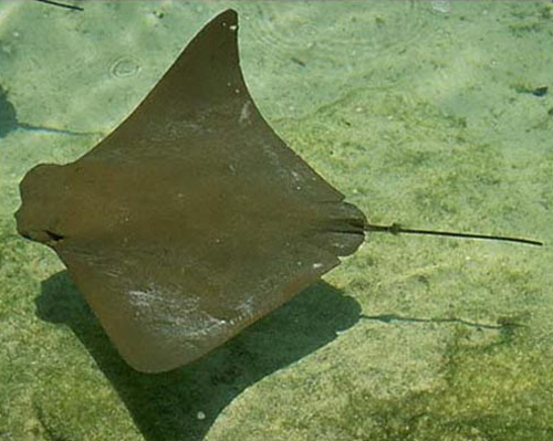
There are two members of the eagle ray family, the cownose ray and the eagle ray, which can be found in our bays. These resemble manta rays but differ in that they lack the characteristic “horns” of the manta (often called the Devil Ray because of them) and they do possess a bard on their tail, which manta’s do not. These are more pelagic rays spending their time swimming in the water column and hunting for buried food.
The cownose ray is often mistaken for the manta ray. It lacks the palps (“horns”) found on the manta.
Photo: Florida Sea Grant
The butterfly ray does resemble butterflies in shape having wide “wing-like” fins and a very small tail. It behaves similar to stingrays burying in the sand and ambushing smaller prey.
Two of the more familiar stingrays are found in our grassbeds, the Atlantic Stingray and the Southern Stingray. The Atlantic Stingray’s disk is more round in shape while the Southern Stingray’s is more angular shaped. The Southern Stingray is larger (disk width about five feet, Atlantic disk width is about two feet) and prefers estuaries with higher salinity. The Atlantic Stingray is very common and can tolerate freshwater, thus is common throughout the bay.
The Atlantic Stingray is one of the common members of the ray group who does possess a venomous spine.
Photo: Florida Museum of Natural History
Stingrays are notorious for their venomous bards and painful stings. They actually try to avoid humans and are frequently spooked by our activity fleeing as soon as they can. However, there are times when people accidentally step on one buried in the sand, or hiding in the grass at which time they will flip their whip-like tail up and over to drive their barb into your foot forcing you to move it – and you do move it – while you yell and scream. The ray then will swim away and can regrow a new barb.
The bard is a modified tooth. It is serrated on each side and there is a thin sac of venom along the flat side of the barb. When it penetrates your foot there is pain enough there. But the natural reaction of your body to an open wound is to close it, this reaction can pop the venom sac and release the toxin. The chemistry of the toxin is not life threatening to humans but is very painful. This experience is something you do want to avoid.
Like their shark cousins, rays do have rows of small teeth which they use to crush small invertebrates including shelled mollusks. They lie in the sand to ambush prey moving in and out of the seagrass beds. They possess two spiracles on the top of their heads which provide water to the gills when they are lying on the seafloor or buried in it.
Like sharks, males can be identified by the two claspers associated with the anal fin and the females usually have two uteri where the young develop. In skates, and some other rays, the young are deposited into the environment within a hardened egg case often called a “mermaids purse”. We see these washed ashore in the beach wrack. Young stingrays usually develop within the female and are born “live” in summer.
Though there is fear of this animal from some seagrass explorers they are a small threat unless you step on one. To avoid this, when in and around the sandy areas of a grassbed, move your feet in what we call the “stingray shuffle”. This is sliding your feet across the surface of the sand instead of stepping. The pressure generated from this movement can be detected by the ray several feet away and they will immediately move away.
Despite the fear, they are amazing creatures and play an important role in the overall health of the grassbed community.
References
1 Snelson, F.F., Williams-Hooper, S.E., Schmid, T.H. 1988. Reproduction and Ecology of the Atlantic Stingray, Dasyatis sabina, in Florida Coastal Lagoons. Copeia. Vol. 1988, No. 3 (Aug 1988). Pp. 729-739.
2 Hoese, H.D., Moore, R.H. 1977. Fishes of the Gulf of Mexico; Texas, Louisiana, and Adjacent Waters. Texas A&M University Presse. College Station TX. Pp. 327.
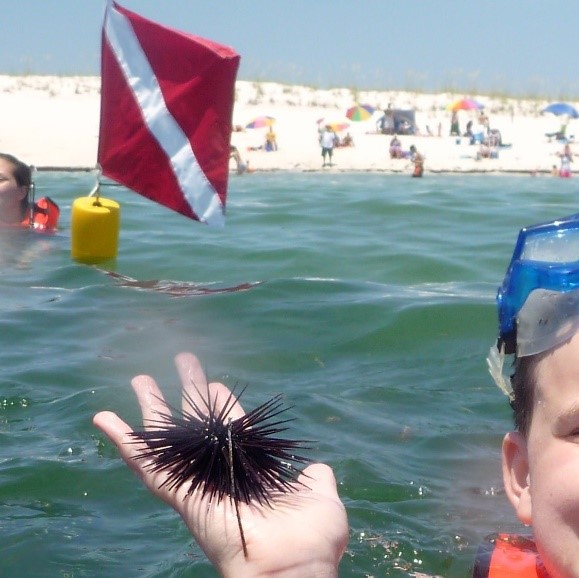
Sea urchins are one of the more commonly encountered creatures when snorkeling in our seagrass beds. At times these little pin cushions can be found in great numbers. In some locations there have been too many and community events have been developed to remove some. In the western panhandle they have all but disappeared. But for many parts of the panhandle, they are a noticeable member of the seagrass community.
According to the Florida Department of Health, most sea urchin species are not toxic but some Florida species like the Long Spined Sea Urchin have sharp spines can cause puncture injuries and have venom that can cause some stinging. Swim and step carefully when snorkeling as they usually are attached to rocks, both on the bottom and along jetty ledges. Photo by L Scott Jackson
Sea urchins belong to the phylum Echinodermata. The term echinoderm means “spiny skin” and is a good name for this creature. This group also includes the sand dollars, sea cucumbers, and the most famous member, the sea stars. Echinoderms are considered advanced and primitive at the same time. Advanced in the sense of organ development, sensory perception, and food gathering. Primitive in the sense that they have radial symmetry, like many of the more primitive invertebrate groups; bilateral symmetry is considered more advanced. The entire phylum is marine, they have no freshwater, nor terrestrial members, and they do like the water salty – at least 20 parts per thousand, and some need it higher than that.
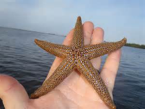
As mentioned, the sea stars are the “star” of the group. They usually have five arms that radiate from a central disk region. On top there are usually small knobs or bumps which are the remnants of their “spiny skin”. Some species, though none in our area, have elongated spines. Beneath the arms is a radial canal which houses a series of gelatinous suckers called tube feet. The sea star can fill these with water using a unique system called the water vascular system. The tips of the tube feet or concave and, when full of water, can create a suction cup that is used for pulling themselves along the bottom and for grabbing food. These canals all meet within the central disk in what is called a ring canal and the water that fills them is sucked in by the sea star through a screen-like structure on the top of the central disk called a madreporite (“screen sieve”). The central disk is where the mouth is located, and it is located on the bottom. Food is worked into the mouth, digested, and excreted through an anus on the top of the central disk. Most species have some form of eye at the end of each arm and have a good sense of smell and taste.
Sea stars are predators, collecting small organisms they are fast enough to catch (which is not many really). But they can also take on larger slow prey, like shellfish. When they approach an oyster, which is sessile and cannot run away, they will grab each of the valves (shells) of the oyster with one of their arms. They will draw water into their water vascular system creating suction on the tube feet and “stick” onto the shells. They will then force the oyster open. Once open they will invert their digestive tract out of their body in a process called evisceration, consume the oyster, then retract the digestive tract leaving two empty shells on the seagrass bed floor. These empty shells are often found by snorkelers – though there are other predators of bivalves.
The Florida Orange Sea Star.
Photo: Florida Sea Grant
Sea urchins differ from their sea star cousins in the way their body is laid out. Imagine you had a five-armed sea star laying on the ocean floor. Imagine taking each of the five arms and rolling them upwards so that the tips of each touch above the central disk. Can you imagine this looking like a ball? A sphere? Now cover the now exposed underside of the arms with long spines (quills) and the tube feet extend between the quills. You have a sea urchin.
Another difference would be the mouth. At the terminus of each arm near the mouth is a single tooth. With five arms, there would be five teeth. Scientists call this set of five teeth Aristotle’s lantern and the urchin uses this to scrap algae from rocks, shells, and grass blades. They are herbivores, moving along feeding on a variety of seaweed and seagrasses in the system.
There is concern with many snorkelers that the quills (spines) of the sea urchin are venomous. That is the case with some species around the world, but not in our area. That said, they are sharp, and the purple urchin (more common in our rock jetties and artificial reefs) hurts. Their quills are sharp and often break off in the skin causing discomfort, much like a splinter. You do not want to handle them, but if you do – handle them with care.
Sand dollars are close cousins of the sea urchin and are in the same class (Echinoidea). If you can imagine taking a round sea urchin and squashing it flat like a pancake, you have a sand dollar. There are also echinoderms in this group that are not as round as sea urchins, but not as flat as sand dollars and are called heart urchins, or sea biscuits. These can be found in grassbeds at the eastern end of the panhandle, but are more common in south Florida.
The sea cucumber is an echinoderm more often found in rocky or coral reef communities, but there are some found in the seagrass beds. To see the relationship between them and their cousins, imagine taking a round sea urchin, lie it on its side, and extended the body so that it is no longer a round ball but an elongated worm-looking creature… sea cucumber. These are primarily scavengers and deposit feeders within the community.
Sea Cucumber
Photo by: Amy Leath
Being a resident of the western panhandle, we have noticed a mass decline of echinoderms in our grassbeds. As a kid in the 60s and 70s we never saw large numbers, as they do in the eastern panhandle, but we did see them. Now they are gone. One suggestion as to why has been salinity. Our bay system over here has more river discharge than those further east and the lower salinity may not support larger populations. The increased development of the years, and the methods of dealing with stormwater, may have created a system that echinoderms do not like. Whatever the reason, finding sea stars and sea urchins in our grassbeds is rare.
The eastern panhandle still has them. And, at times, too many. In recent years there has been an increase in sea urchin populations in St. Joe Bay that has led to overgrazing of the turtle grass. This could lead to a decline in suitable habitat for bay scallops, which the community depends on economically. The state currently sponsors a “Sea Urchin Round Up” event using humans to help control the overabundance of sea urchins.
Echinoderms are a visible, and interesting, part of our seagrass community.
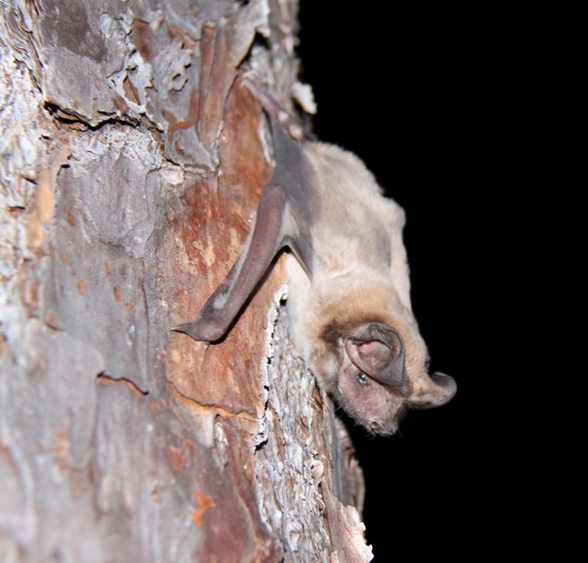
My wife and I like to sit on our back porch and watch the sunset each day. We do not make all of them, but we try to make as many as we can. We often see small bats darting in all directions feeding on bugs. Recently we were enjoying a particularly great sunset. The sky was a light blue with streaking clouds of dark gray, purple, orange, and white. It was amazing. As the streetlight came on, we could see a swarm of termites gathering around it. There were a lot of them, but we also noticed the increase in bats. There was a dozen at least, probably more, zipping in and out, darting in all directions. We enjoyed watching them and wondered where all of them were roosting.
Bats sometimes move into buildings when they can’t find the natural structures they prefer (caves and large trees with cavities).
Many people are afraid of these creatures. They have been associated with Halloween, horror, vampires, and rabies. They are creatures of the night, and that is unsettling in itself for many. But, as biologists say with most creatures, these stories and legends are just that… stories and legends. Some members of their population do carry rabies, but most do not and the transmission of the disease to humans is rare. The animals are small furry mammals that eat an enormous number of insects each evening, including flying termites and mosquitoes. Many help pollinate plants and help disperse seeds. They are really pretty cool.
There are around 1400 species of bats worldwide1, 13 of these are from Florida2. Though some species feed on fruit and nectar, most feed on insects and consume about half their body weight each evening doing so. The Bat Conservation International states that insect consuming bats may save U.S. farmers $23 billion dollars a year in pesticide use due to their insectivorous diet1. The agave plant, the one used to produce tequila, is primarily pollinated by bats. The 13 species found in Florida are all insectivores feeding on beetles, mosquitos, moths, and other agriculture and garden pests. They are truly beneficial.
Bats are mammals, having fur covered bodies, live birth with young nursing on milk, and being endothermic (warm blooded). Most connect bats with the mammalian order Rodentia (rodents) – often calling them “flying rats”, but – due to the type of teeth – they are actually in their own order Chiroptera. They are the only true flying mammals in the world, the flying squirrel is actually a glider, not a true flyer. They live in a variety of habitats in Florida including pine forests, hardwood forests, riverine systems, lakes, and in urban areas. They most often roost in the crevices of dead trees, beneath the dead fronds of palms, and in Spanish moss. But when available, they will use caves and are notorious for using buildings, culverts, and the underside of bridges.
They fly using wings that are actually thin skin between their extremely elongated fingers. They breed in the fall and give birth to a single pup in the spring. One of the legends is that they are blind. As mentioned above, this is a legend. Bats can see well and see better than we do in dim light. They do have the ability to use high frequency sounds to “echo” off objects in the dark (echolocation) which helps them find, and follow, their insect prey at night. You can notice this hunting tactic as the sun sets and view the bats darting in all sorts of directions chasing their prey.
Most of the 13 species of Florida bats can be found in the Florida panhandle, with the gray bat only found in Calhoun and Jackson counties and nowhere else in the state. Rabies is a concern with bats, and it is true that an infected bat with the disease can transmit it to humans, but this is very rare. That said, anyone who is bitten by a bat should seek medical attention. The animal was also connected with the transmission of COVID during the early period of the pandemic3. Bats, like many other mammals, can pass infectious diseases and there is also a fungal growth associated with their droppings that has caused medical problems with some humans. If working in an area where bat guano is abundant, a mask is recommended. If an injured animal is found in your yard, wear a pair of gloves and take it to your local wildlife rehabber.
Florida bats do face problems in our state with the loss of habitat. We often remove dead trees and cut dead fronds from palms. The benefit we receive from them (consuming thousands of pest insects each night) leads to a need for their conservation. To date, the white-nose syndrome, which has infected many bats north of us, has not reached Florida but is of concern. Despite the fear many have of this animal, they are quite beneficial and should be allowed to exist in our panhandle habitats.
Species found in Florida:
Mexican Free-tailed bat
Southeastern myotis
Evening bat
Eastern red bat
Seminole bat
Northern yellow bat
Tricolored bat
Gray bat – endangered; only found in Calhoun and Jackson counties.