It sounds like one of those Sci-Fi thrillers where there is a giant asteroid heading to Earth and we need a special team led by Bruce Willis to save the planet. But in this case it is not a large rock, but a large mass of seaweed. And the threat is not a huge impact that would form tidal waves and atmospheric black out but large masses of seaweed covering the beaches up to a foot or more. Once on the beach, the mass of seaweed would begin to break down releasing odors and attracting insects that would not be popular with tourists – just as we get into the peak of tourist season around the state.
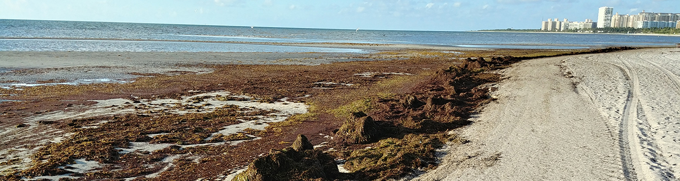
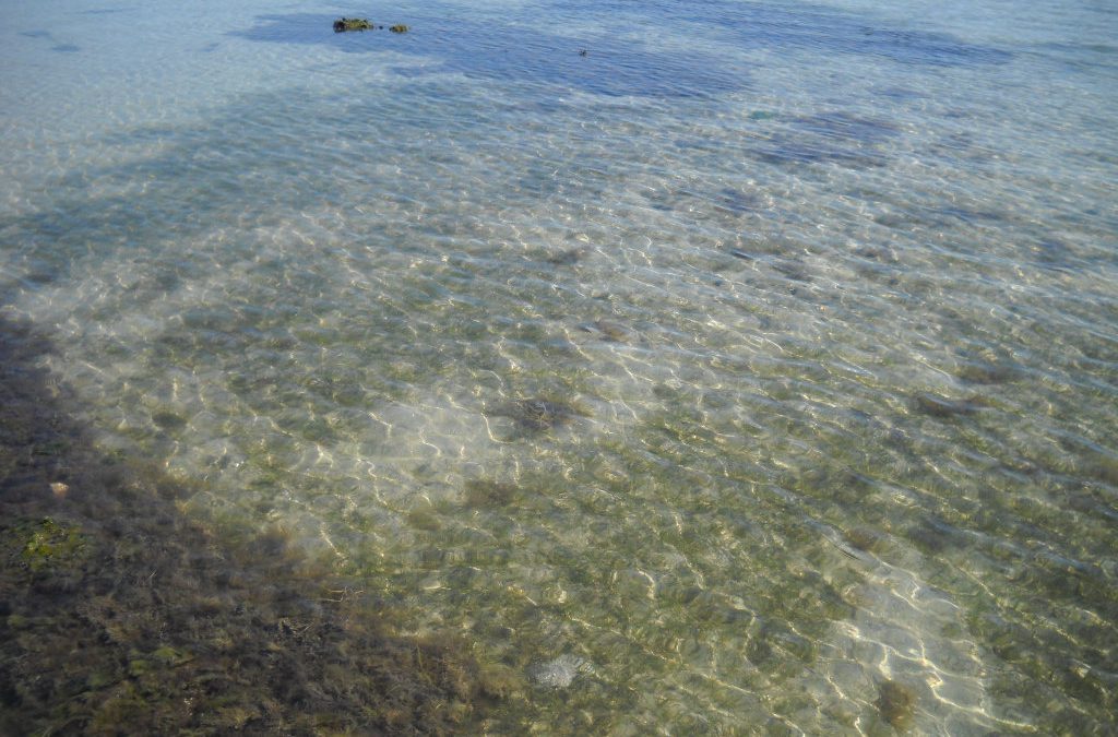
Mats of Sargassum on a south Florida Beach.
Photo: University of Florida
It is not something new, this has been a problem in south Florida for a few years now, but this year scientists can see the massive blob of seaweed heading this way and it is larger than before. They are expecting some beaches in Florida to be heavily impacted.
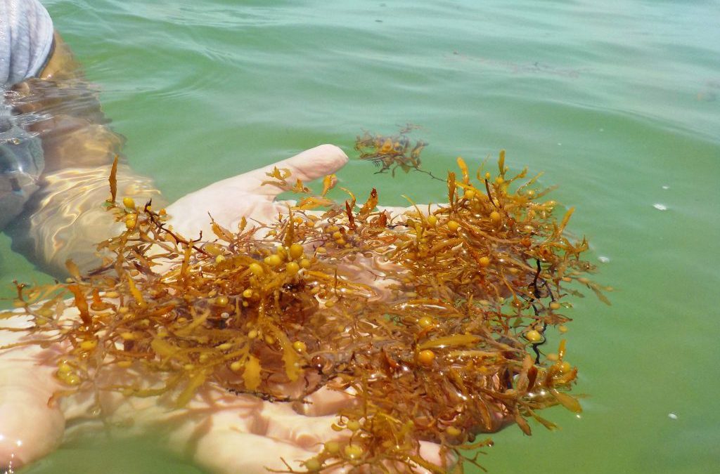
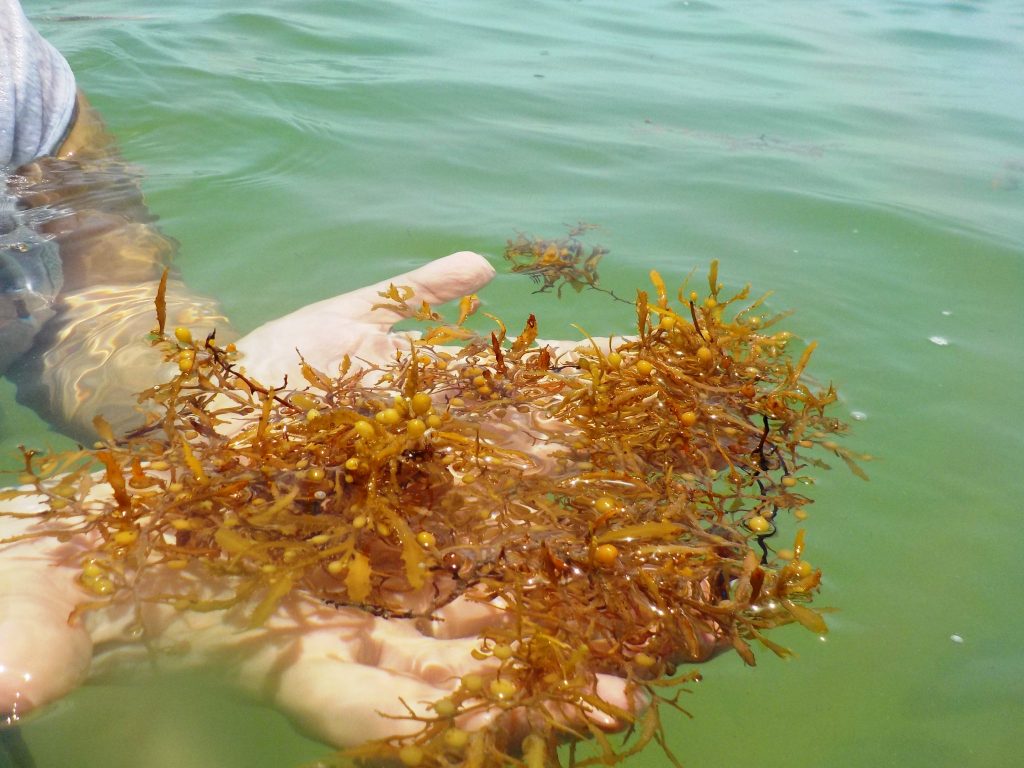
The seaweed in this floating mass is a brown algae known as Sargassum (Gulfweed). Like many brown algae’s, it is yellowish-brown in color and possesses small air bladders called pneumatocysts. These pneumatocysts allow large brown algae, like kelp, to stand tall like a tree in the water column – or, like Sargassum, to float on the surface where they can reach the much-needed sunlight.
Sargassum has small air bladders called pneumatocysts to help them remain afloat on the surface.
Photo: Florida Sea Grant
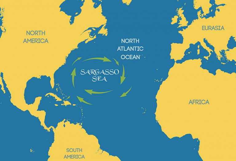
There are two species of Sargassum that are found in the South Atlantic: Sargassum natans and S. fluitans. They are not easily distinguished so most just say “sargassum”. These seaweeds form large floating mats that drift in the ocean currents. The clockwise rotation of the North Atlantic gyre creates a central point around which the currents spin that is calm – similar to the eye of a hurricane. Here, the sargassum collects in large masses and was noted in the logs of Christopher Columbus as the “Sargasso Sea” – a place to avoid for colonial sailors due to the fact there is little wind or current here.
The Sargasso Sea
Image: University of Florida
Mats of this algae creates an ecosystem drifting across the sea housing transient and residential species that have been the study of marine biologists for decades. The seaweed will get caught in currents that bring it close to shore where fishermen seek it out fishing for jacks or mahi-mahi. Baby sea turtles will use it as refuge until they are large enough to return to the shores of the continents and islands. It will at times get caught in currents that bring it ashore where beach combers sift through to see what they can find. As we mentioned, once on dry ground the seaweed begins to die releasing the odors of decaying sea life and attracting an assortment of insects. When this happens coastal communities will use tractors to drag and remove the smelly mats and deposit them in the local landfill.
In recent years, in south Florida, the amount of this seaweed has increased. The seaweed has formed large mounds on the beaches making beach combing an ordeal and the smell unbearable in many communities. Some of the Sargassum finds its way into the canals of the Florida Keys where it sits and decays, decreasing dissolved oxygen and causing a decline in abundance of some local marine communities. They have responded by removing the Sargassum to the local landfill but are experimenting with composting the material for fertilizing other plants.
Several researchers have experimented with the composting idea with some encouraging results. Some have found a use for it as mulch for coastal mangrove shoots that have lost much of their natural fertilizers due to coastal urbanization. There are problems with using this in some plant settings. 1) It could be too salty for some landscape plants. 2) There is the concern of the amount of arsenic present. Studies continue.
The recent large masses of Sargassum coming ashore began in 2011. What is causing this recent increase in Sargassum on the beaches? Researchers are finding the source of this material is not mats rotating off of the Sargasso Sea but forming in the belt of moving water between the North Equatorial Current in the south Atlantic and the equator itself. The exact cause of this increase growth is uncertain but could be linked to an increase of nutrients from regional rivers, like the Amazon, and from increased ocean temperatures due to climate change – both of these are exactly what seaweeds like.
This year the mass of seaweed seen from satellites is particularly large – over 5,000 miles. It is drifting in the currents heading for the Caribbean and Florida. It will most likely impact south Florida, but researchers do not believe the impact will be as large along Florida panhandle beaches. They will continue to monitor and report on the movement of this mass of seaweed over the course of the summer.
Many in the Florida panhandle are aware of the importance of seagrasses to estuarine ecology. They have heard this many times before and have heard how important it is to protect them. Some are aware that they are important as a nursery for many commercial important fin and shellfish. But fewer are aware of the diversity of life that exists in these “fields of grass”. Much of the life there is small and unnoticeable until you don a mask and explore. Even then, you need to slow down and look closely.
In this series on “Sea of Grass” we will be looking at some of the species that reside in these massive meadows expanding the Florida panhandle. We begin with the grasses themselves.
Seagrasses are just that – grasses that grow “under the sea”. They are similar in many ways to the grasses that grow in your yards. Their blades extend above the sediment and are usually all one sees as they are exploring the meadows. Being true plants, they do have stems – but these stems run horizontally beneath the sediments and are called rhizomes. Rhizomes are like “runners” and extend the plants across the landscape. Many have discovered rhizomes in their yards when pulling weeds. You begin to pull and a the runner exposes itself like pulling a thread from a sweater. From these rhizomes extend the small roots. Like lawn grass, seagrass use the roots to help anchor them in place and remove water and nutrients from the environment. But they are immersed in water and, like many marine creatures, have the ability to desalinate it so they have a source of freshwater.
Like all plants, seagrasses require sunlight for photosynthesis. Thus, they must grow in shallow water. In the western panhandle they are limited by the availability of light and are usually found in the estuaries where the water depth is not more than 10 feet. As you move into the eastern panhandle, particularly close to where the Big Bend begins, there are fewer large rivers depositing muddy water, more expanses of salt marsh to remove sediments from runoff, here seagrasses can grow deeper. Here they can expand into the open Gulf of Mexico itself producing hundreds of thousands of acres of these grass meadows.
Seagrass beds have declined over the last half century.
Photo: Rick O’Connor
They are not fond of high energy systems. Large waves can rip seagrasses from the bottom and deposit them onshore. In the western panhandle the Gulf generates larger waves and thus the grasses are found in the protection of the lagoons, sounds, and bayous. Near the Big Bend natural wave energy is low enough to support them in the open Gulf. It has been estimated that Florida has between 2.2 and 2.5 million acres of seagrass. Most of this is along the west coast of the peninsula running from the Florida Keys to the Big Bend1.
There are seven known species of seagrass in the state. Three of these are common in the panhandle and an additional one, Manatee grass (Syringodium filiforme), is beginning to expand its range into our area.
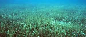
An amazing meadow of turtle grass.
Photo: Virginia Sea Grant
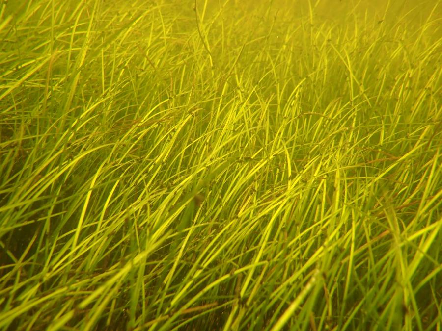
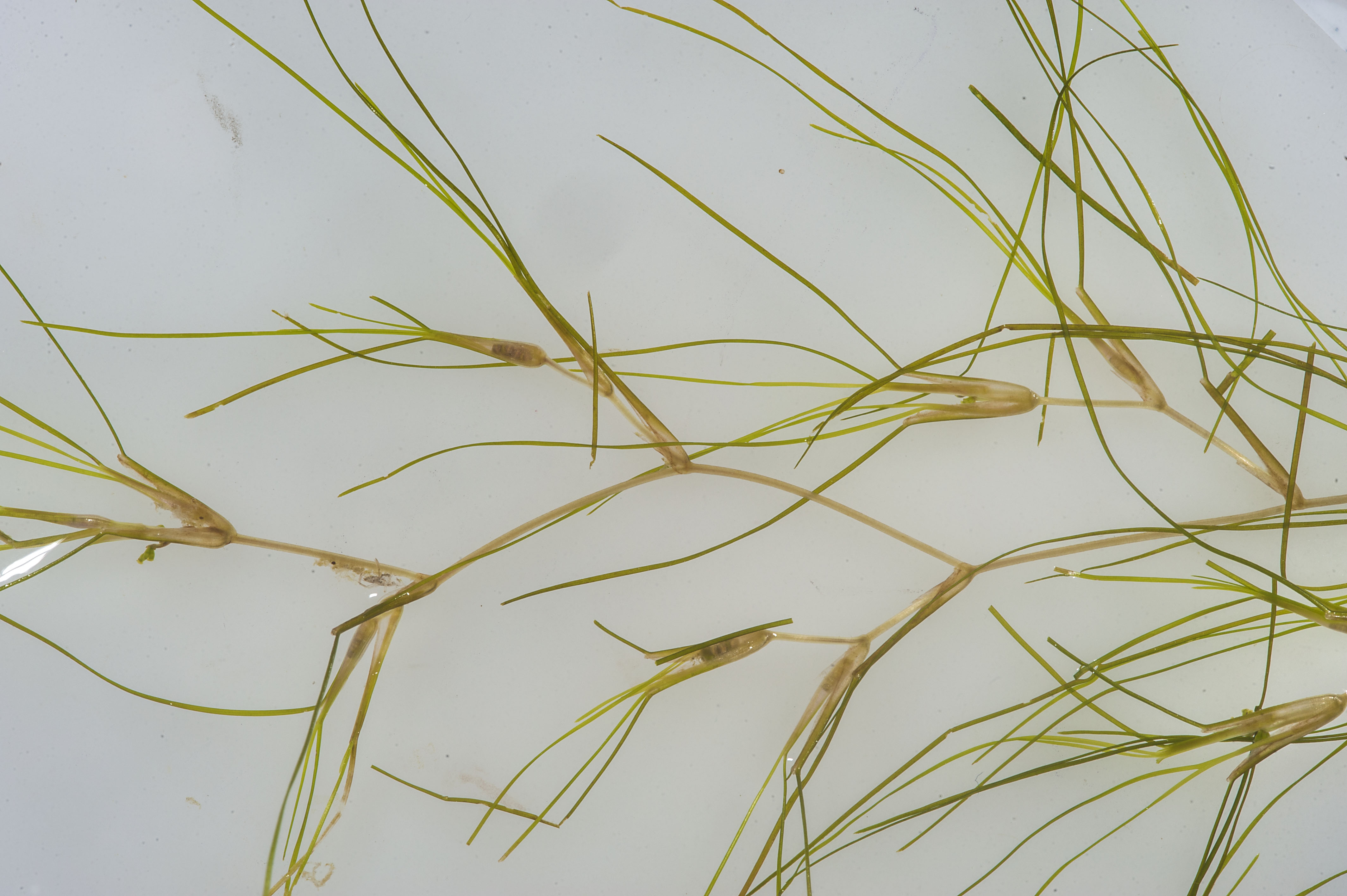
Two of our common species prefer more saline water – water with a salinity at least 20 parts per thousand (ppt). Those are Turtle grass (Thalassia testudinum) and Shoal grass (Halodule wrightii). These grasses both have flat blades but differ in blade width. Turtle grass is wider (4-12mm) and resembles St. Augustine grass from our lawns. Because of the wider blade, they grow in deeper water (not being able to tolerate the break waves and whitecaps near the surface). Shoal grass is very thin (<4mm) and feels more like human hair when you run your toes and fingers through it. Manatee grass resembles shoal grass in size but has a round blade instead of a flat one. In the Pensacola area we are beginning to find patches of it growing in Big Lagoon and Santa Rosa Sound.
Shoal Grass
Photo: Florida Department of Environmental Protection
Widgeon grass (Ruppia martimia) can tolerate the higher salinities of the lower estuary but can also tolerate the lower salinities of the upper estuary. It dominates the lagoons and bayous of the upper Pensacola Bay system. It has a thin flat blade like shoal grass but differs in that it branches as it grows instead of a single blade extending about the surface.
Widgeon Grass
These meadows of seagrass provide food and habitat for a myriad of marine creatures, who we will meet in other posts in this series. In Part 2 we will begin with one that is very important but very few know is even there – the epiphytes.
It seems odd that we would be talking about maintaining your sewer system; that was a selling point to convert from septic. But there are things we do that can cause clogs in the lines that initiate what we call Sanitary Sewage Overflows (SSOs). These overflows can overflow into your home and into the street, entering the stormwater systems leading to our coastal waterways.
How you can prevent this is pretty simple – watch what you pour down your drain. After visiting one sewage treatment facility in Georgia, we were told by the plant manager “If you tell the public one thing… tell them to quit pouring bacon grease down the drain”. He then held up a pipe from their system that was 80% clogged with bacon grease. All fats, oils, and grease poured down the drain eventually solidify and form clogs. Recently they have found that milk solidifies as well. You should avoid pouring all of these products down the drain.
So, what do we do with it them?
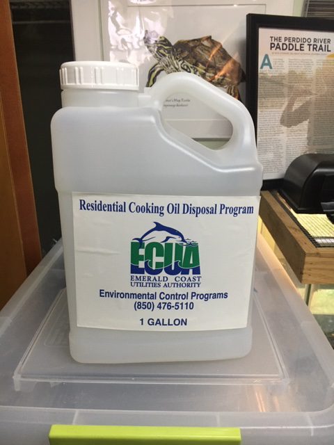
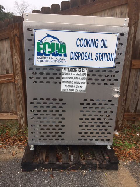
In Escambia County, the local utility provides a free service to deal with this they call the FOG Program (FOG – Fats, Oils, Grease). They provide large metal cabinets outside locations around the community. Inside, there are 1-gallon plastic containers. You take one home. Fill with your fat, oil, and grease. Return it and get a new one. They take these oils back and covert them into biofuels. It is very similar to the propane system for your BBQ grill – and often found at the same place – but the difference is that there is no charge. If you live in Escambia County, you can find the FOG dispensary cabinet closest to you at ECUA FOG. If your county does not offer this service, encourage them to do so.
The FOG gallon containers are found in these metal cabinets placed around the county.
Photo: Rick O’Connor
Another issue that has caused SSOs is the flushing of “flushable wipes” and similar products. They are “flushable” but not “degradable”. There was one report from London of a ball of flushable wipes equivalent in size to one of their buses found in the city sewer system. I have seen signs in public restrooms that say “flush nothing but toilet paper” – and that is good advice.
1-gallon container provided free to dispose of your oil and grease.
Photo: Rick O’Connor
And there is one other thing that you, the property owner, can do to help reduce the chance of leaking sewage into our waterways – maintaining your laterals.
Laterals are the pipes extending from you house to the sewer system under the street. Maintaining these are the responsibility of the homeowner, and most do not – or may not know it is their responsibility. Newer developments should have laterals in good shape, older ones should be inspected. I live on an older community in Pensacola. Many of the houses in our neighborhood were built in the 1930s, some in the 1920s. The laterals were made of terracotta, or something similar. They have cracked and filled with roots and dirt over time. There is certainly leakage ongoing, and the homeowner may not even know it.
This past summer we had a sewage backup. We called a plumber who first recommended scoping the laterals. This involved sending a television camera scope down the line. We found that half way between our house and the street it was relatively new PVC line. From the halfway point to the sewer line in the street, it was old terracotta. The sad part of this was we had paid a contractor to replace the terracotta to the street – they only did half. You would say this fell on the contractor to fix, but that contractor was no longer in business – if fell on us. We paid to have the rest of the lateral converting to PVC, we are now good.
The point of this story is two things… (a) many have never had their lateral surveyed, you should to make sure all is good. This is not only good for the environment, but also will save costly repair bills down the road. (b) Just because you paid to have to have it repaired does not mean it was. I recommend you use a certified, well known plumber to check and, if needed, replace/repair your line.
If the property owner will consider, and act on, one of the following three this can reduce the health advisories issued in our coastal waters significantly. We encourage you to do so and educate your neighbor and friends to do the same.
If on septic, develop and enact a septic tank maintenance plan.
Convert from a septic system to a sewer system.
If on sewer, have your laterals inspected, do not pour fats, oils, grease, or milk down the drain, and do not flush flushable wipes or similar products.
If you have further questions, do not hesitate to contact your county extension office.
Part of the 2019 UF IFAS social media survey across Florida found that many Floridians understood how septic systems worked, but fewer understood how sewer systems functioned. This article is going to try and tell you the basics of how sewage treatment works.
As we just mentioned, many people have no idea where their sewage goes after they flush – nor do they care – as long as it does not stay here 😊. When we flush – it goes – and that is all we think about. This is one of the advantages of sewer over septic – you do not have to maintain anything. You just flush and go. However, we will see in Part 4 that there are some things that are still on us to help keep sanitary sewage from reaching our coastal waterways.
So – where does the sewage go when we are on a sewer system?
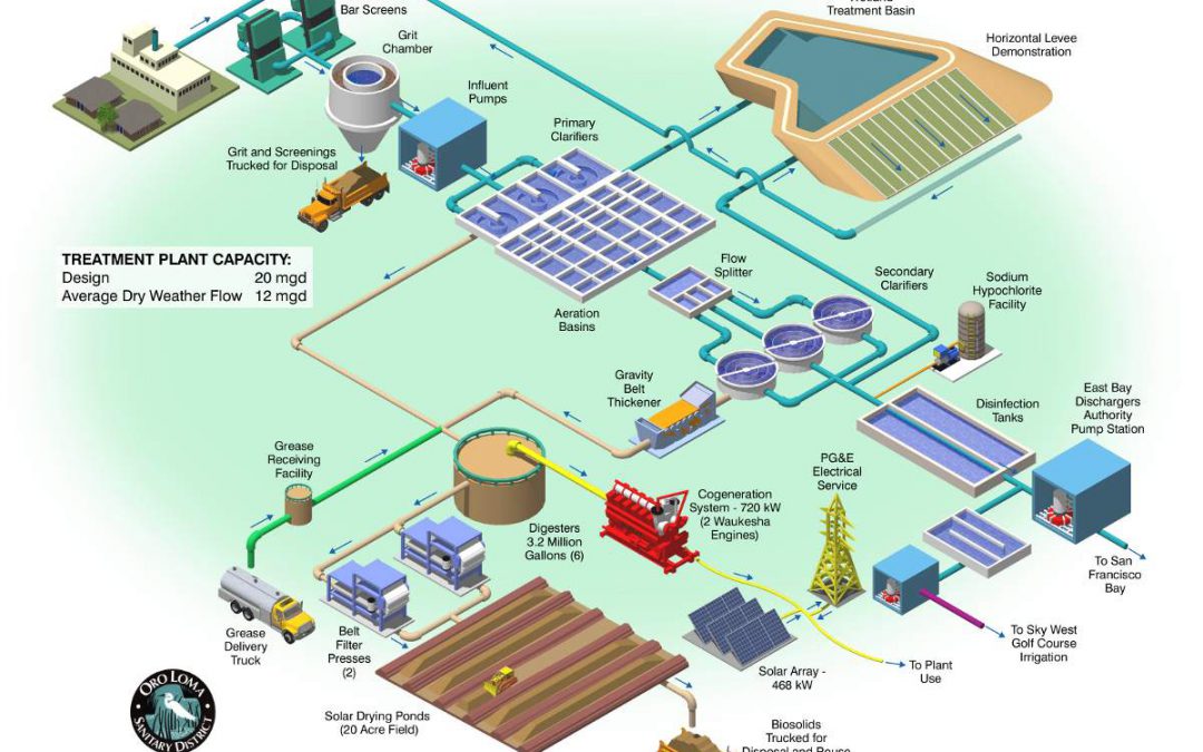
The raw sewage leaves our house through a pipe called the lateral. This line connects to the municipal sewage line under the street. From here it flows to the local sewage treatment facility. In some communities, this is downhill from the residential area, and the sewage flows via gravity. In others, it is uphill and must use a series of pumps, or lift stations, to get the raw sewage to the treatment plant.
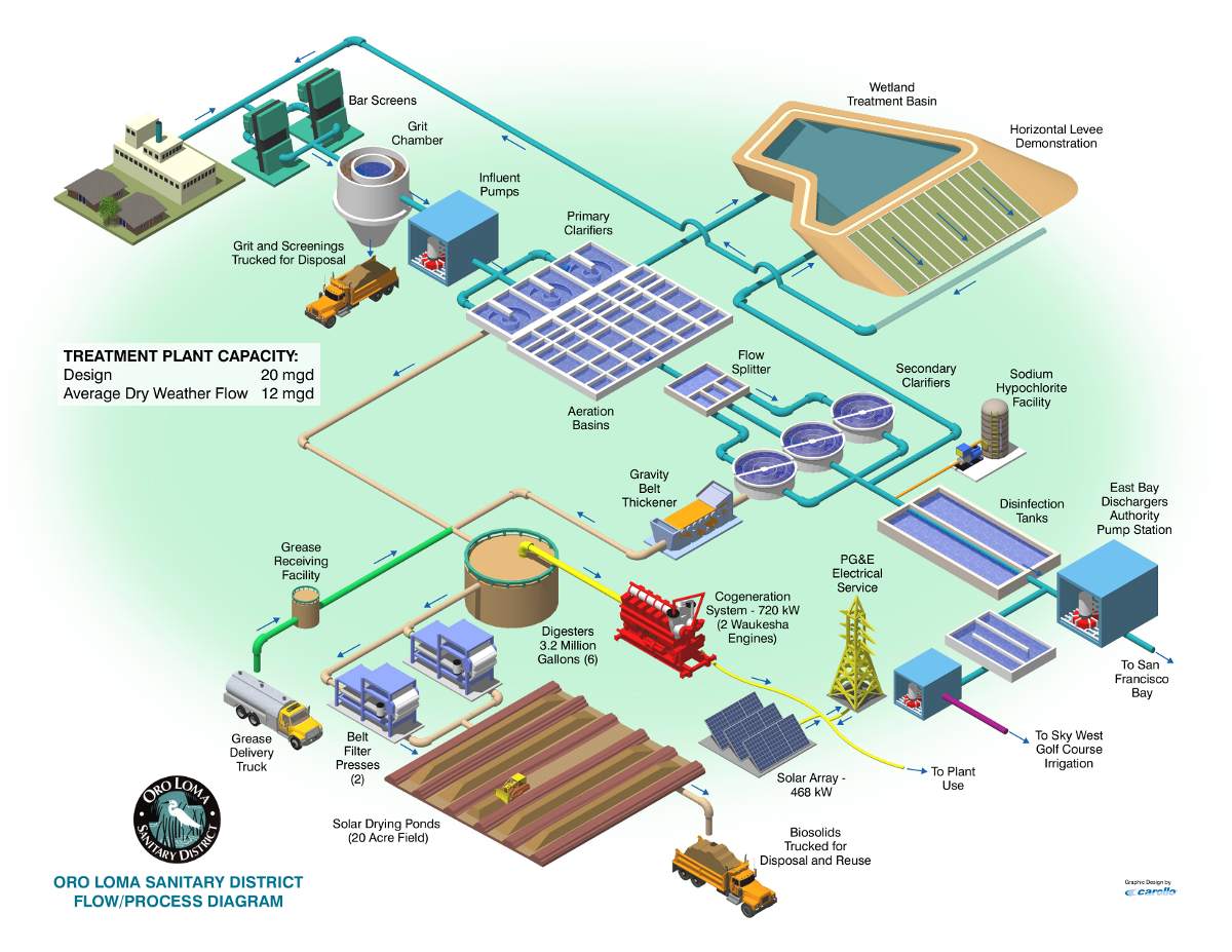
Sewage treatment facility.
Image: Oro Loma Sanitary District.
Once it reaches the plant the sewage undergoes PRIMARY TREATMENT. This is a series of methods that physically treats the waste. Often, stop #1 is a screen that removes large objects. You would be surprised what ends up in the sewer lines heading to the treatment facility. Wood, boxes, and plastic bags. I heard one treatment plant found a small hog in their screen system.
Once past the screens the wastewater is run through a grit chamber. This continues the physical process of removing large objects from the wastewater as it trickles through. Material such as sand and rock settles to the bottom of the chamber. This settled material can be removed, treated, and disposed of.
The effluent (water) continues on to stop #3 – the settling tank. Here it is allowed to sit so that smaller fine solids can settle to the bottom of the tank – not that different if you placed muddy water into a clear 1-gallon jar and allowed it sit, the mud would slowly settle to the bottom making the water clearer. This settled material contains much of the solid waste from when we went to the restroom. Here it is called sludge. The sludge is drained off, treated, and usually dried in a pile that would resemble dirt. Some communities load this into trucks and take it to a designated area in the landfill. Some communities will use it as a fertilizer on crops. Some countries allow this but not for crops that will be used as food. I heard some locations around the world use the dried material to form bricks and building materials.
Studies show that primary treatment can remove as much as 60% of the suspended solids and 30-40% of the organic waste that is oxygen-demanding in an aquatic system.
But…
It does not remove pathogens that maybe be in the sewage, phosphates and nitrates that can cause eutrophication, salts which alter the salinity and living conditions for aquatic life, radioisotopes, nor pesticides. For this, we will need secondary treatment.
The clearer effluent remaining after settling moves to SECONDARYTREATMENT. Where primary treatment was a physical method of treating wastewater, secondary treatment is a biological method. Stop #1 is the aerationtank. Here the effluent is aerated using a sprinkler system that provides oxygen so that the microbes living in the tank can further break down any pathogens and other biological demanding waste. This treated water is then sent to a second settling tank where more sludge is allowed to settle. The settled sludge is then cycled back into the aeration tank – and the process continues. The clearer water at the surface of the second settling tank is then sent to a tank where is disinfected – often with chlorine. If balanced correctly, the amount of chlorine added is enough to kill much of the remaining bacteria but not high enough to be a threat to the environment. This water is then analyzed for contaminants, including fecal bacteria, and – if it passes the test – is discharged into a local waterway as treated sewage. Studies have found that a combination of primary and secondary treatment can remove 95-97% of the suspended solids and oxygen-demanding waste, 70% of most toxic metal compounds, 70% of the phosphorus, and 50% of the nitrogen.
For many communities this is good and is the end of the line. For others, they are willing to spend additional dollars and move to more advanced treatments before discharge – what is called TERTIARY TREATMENT. One method of tertiary treatment is using a series of filters that can reduce the levels of phosphates and nitrates remaining in the effluent. These compounds are the ones that trigger eutrophication and algal blooms and many communities feel the extra charge on their bill is worth it. These filters can actually remove some viruses. Some use chlorine for a second round, however studies have shown that increased amounts of chlorine can react with organic materials to form chlorinated hydrocarbons – which have been linked to cancers, miscarriages, and damage to human nervous, immune, and endocrine systems. For those going this route, many have opted for UV radiation or ozone treatment in lieu of more chlorine.
After either secondary or tertiary treatment, many municipalities run their treated effluent through a marsh or swamp before it reaches the open water systems. Studies have shown that these plants are very good at up taking nutrients, and some other contaminants, as the water flows through them.
Many feel this is a better method of treating human waste than a septic system. One point is that YOU do not have to manage your tank – the city does. Though this is true there is a monthly bill to pay for this service and some would rather not pay that. It is also important to understand that you are not quite off the hook yet. There is maintenance needed to the sewer system BY THE HOMEOWNER, and we will discuss this in Part 4.
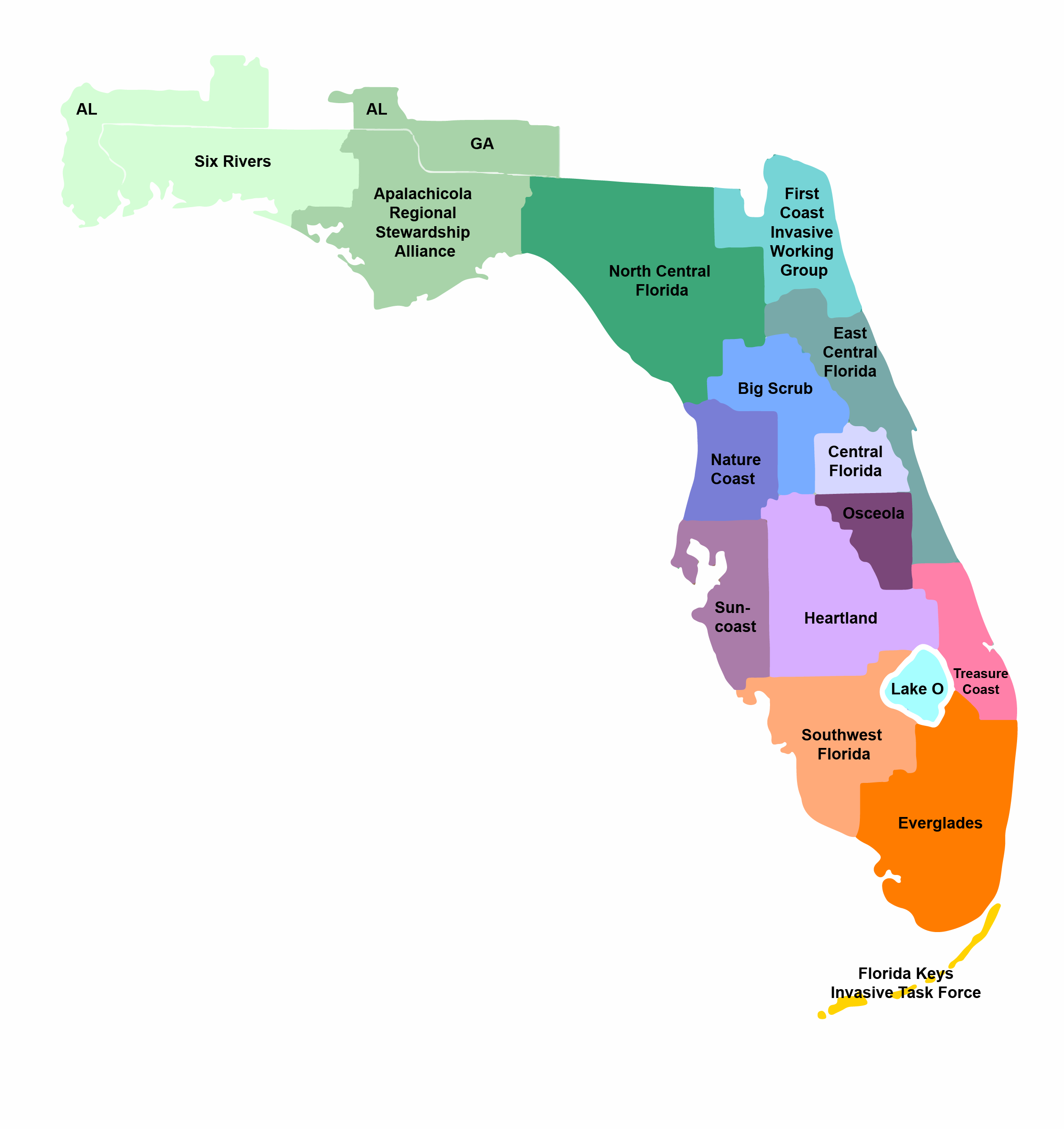
Over the course of the last week, we have been discussing invasive species issues from across the panhandle. The primary purpose was to provide information for local decision makers to develop management plans for these species. The second was to educate the local residents about which species are the largest concerns in their counties so that they too could help with management.
Cogongrass (Ray Bodrey)
Three species came up more than once: lionfish, feral hogs, and cogongrass. All three of these present large problems for the panhandle and all three are well established – party of the “dirty dozen”. In each case eradication is probably not an option. But as Ian Stone’s article from Walton County on cogongrass shows, a well thought out plan with buy in from everyone can make a difference on how bad of an impact they will have. Georgia was able to significantly reduce the impact of this grass with their comprehensive plan. The 2018 Lionfish Workshop in Ft. Walton Beach also showed that a team effort across the panhandle has helped manage that problem. Though we did not hear from Chinese Tallow, Chinese Privet, or Japanese Climbing Fern, similar efforts can go along way to reducing their impacts as well.
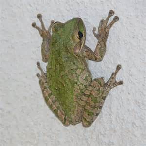
Cuban Treefrog
Photo: UF IFAS
We also learned about “new kids on the block” with Giant Salvinia and Cuban Treefrogs. Depending on how widespread these species are currently, eradication is possible. What it will take is an Early Detection and Rapid Response (EDRR) approach. To be successful at this local decision makers and residents will need to know:
Which species are potential threats to their counties.
How are those species transmitted.
How are they managed.
How many do you currently have in your county.
At this point the community can develop a plan to eradicate what you have and keep anymore from entering. You can find answers to these questions at your county extension office, your local CISMA website, and the EDDMapS website.
Again, with a team effort, we should be able to manage invasive species in the panhandle and reduce their impacts. As always, you can contact your county extension office for more information on invasive species issues in your area.