There are more invasive plants issues in Escambia County than animal ones; but we do have animal invasives. Some have been with us for some time, like the feral hogs which will be posted in a different article, some are more recent. In this article we are going to focus on two species that could become real problems for us without some management plan – the lionfish and the Cuban treefrog.
The Invasive Lionfish
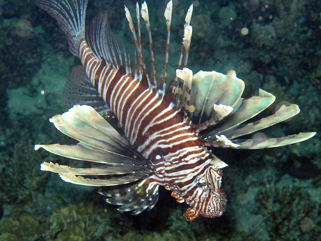
The red lionfish (Pterois volitans) has been in the local news for some time – but as a Gulf of Mexico problem. The fish is from the Indo-Pacific region of the world and was brough here for the pet trade. The first records we have of it in the wild were in southeast Florida in the 1980s. We are not 100% sure how they reached the Atlantic Ocean, but they did – and they did well.
Lionfish display a courtship dance where, near sunset, the males and females rise off the reef in a rotating swimming pattern and then fertilize their eggs. On average, each female will fertilize 30,000 eggs every four days! These fertilized eggs are encased in a gelatinous sac that drifts with the currents and is a method of spreading the species across the region. Originating in southeast Florida, the Gulf Stream dispersed them north along the coasts of Georgia and the Carolina’s. From here the invasion moved east to Bermuda where the Atlantic currents cycled them back south to the Caribbean, here they invaded every reef system in the region. From the Caribbean they found there way to the Florida Keys and eventually into the Gulf of Mexico. The first record in Escambia County was in 2010. It has been described as one of the most prolific, and successful, invasions of a non-native species ever.
Studies show that the invasion in the Pensacola area was particularly bad. One study showed that the densities in our area were some of the highest in the south Atlantic region. Another study showed they had preference for artificial over natural reefs. In response, the Escambia County Division of Marine Resources, partnering with Florida Sea Grant, developed a series of local workshops to educate the public about the issue.
From these meetings nonprofits formed that began to have “rodeos” and “roundups” providing prizes to divers who could remove the most, the largest, and even the smallest lionfish. Eventually the Florida Fish and Wildlife Conservation Commission (FWC) joined in and created the Lionfish Removal and Awareness Day (LRAD). This event, which began in Pensacola, attracted thousands of curious people, chefs cooking samples, and divers from across the region. These efforts, along with an increase in commercial harvest (the fish is edible) have made a significant impact on populations in waters less than 200 feet (where divers can safely work) – but lionfish can live as deep as 1000 feet.
In 2019 a gentlemen fishing on the pier at Ft. Pickens caught one on hook and line. Charter captains have been catching them on hook and line for a few years but it was not common and usually in low numbers. Over the nine years since the first record, there had also been three records within Big Lagoon, so – finding one inside of the pass was not new, but concerning. Partnering with the Ocean Strike Team, Sea Grant conducted a series of survey dives to assess the status of lionfish near the pier and jetties of Ft. Pickens. They found them – though in small numbers, lionfish were present.
The question now is how far within the bay has this invasion spread. The concern is two things.
Lionfish are gregarious feeders – eating just about anything they can get into their mouths. Offshore they are known to eat no fewer than 70 species of small reef fish, including the commercially important vermilion snapper, and several invertebrates, including shovel nosed lobsters. If they invade the bay, we are now looking at juvenile shrimp, blue crabs, flounder, redfish, and more. The impact could be very big.
They are venomous. Not by bite, but by spines. Though it has not killed anyone, the “sting” of a lionfish is extremely painful and placed some in the hospital. With numerous locals and visitors swimming in our estuarine waters, encounters with this fish will occur, and problems with envenomation will follow.
The response needed from the county is to develop a management plan for this fish in our bay. Studies show that the most effective, and least costly, methods occur at the early stages of the invasion – Early Detection Rapid Response. There are several agencies, including Florida Sea Grant, ready to assist with this.
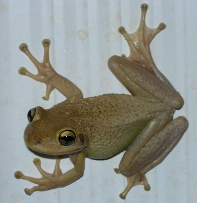
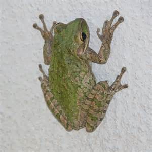
Cuban Treefrog
Photo: UF IFAS
As the name implies, the Cuban treefrog (Osteopilus septentrionalis) is from Cuba – though it is native the Bahamas and the Cayman Islands as well. Records show they arrived in the Florida Keys in the 1920s – most likely “hitchhiking” on boats crossing the Florida straits.
This is a large treefrog, can reach six inches – compared to the two inches of our native frogs, and quickly moved in consuming local wildlife. As with many invasive species, their numbers increased quickly, and they became common across the landscape. In most locations where Cuban treefrogs were present, NO native frogs could be found. Studies show that in pools where Cuban treefrog tadpoles exist, no native tadpoles survive. Native frog populations began to decline. This is a large treefrog, not only do they consume native frogs, but they also consume small lizards, snakes, and all sorts of insects.
But the problem goes beyond native ecology. These treefrogs love to be around humans. Residents complain of the numbers of these large frogs on their doors and windows in the evening. They defecate making a large mess and the calls of the males sounds like a squeaky screen door keeping folks up at night – especially when they are abundant and there are no other frogs in the neighborhood. They are known to enter vent pipes in the plumbing, sometimes clogging these pipes, often appearing in your commode when you lift the lid to use the restroom. People do not like them. They are also known to hideout in electric panels and often short circuit home electrical and HVAC systems. Some of these problems become costly to the property owners.
The Cuban treefrogs have dispersed out of south Florida. They are now established as far north as Gainesville, Jacksonville, and Cedar Key. But records in the Florida panhandle, including Escambia County, are increasing.
Our part of the state was once immune to invasions of tropical species such as this frog. Our winters were cold enough to eradicate the few that made it here. We think the most frequent method of invasion is by hitchhiking – just as they originally did. Many of the landscaping plants we purchase for our homes and neighborhoods are grown at large nurseries in south Florida. These plants are loaded onto trucks and brought here – bringing Cuban treefrogs, Brown anoles, and many other small frogs and lizards that can be a problem for us. It appears that our winters are becoming milder, and these invaders are now surviving. Dr. Steve Johnson (University of Florida) has verified a breeding colony of Cuban treefrogs in Bay County. Records and calls from Escambia and Santa Rosa counties are increasing. We do not know whether these populations are breeding – but the concern is there.
Florida Sea Grant plans to develop a citizen science monitoring project in the spring of 2023 to assess the status of these frogs in our county. As with the lionfish, early detection – rapid response is the key to managing them.
If you are interested in participating in either the bay lionfish surveys, or the Cuban treefrogs surveys in Escambia County, contact Rick O’Connor at the Escambia County Extension Office.
National Invasive Species Awareness Week (NISAW) is a national initiative where agencies and organizations provide information on invasive species issues to decision and policy makers. It can also be a time where we provide that information to the general public.
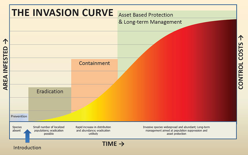
Invasive species are a global problem threatening biodiversity everywhere. Many create economic problems for the communities they invade, and management can be costly. The University of South Florida has estimated the cost to be around $21 billion a year in the U.S. alone. The most effective method of management is to detect the invader early and respond rapidly.
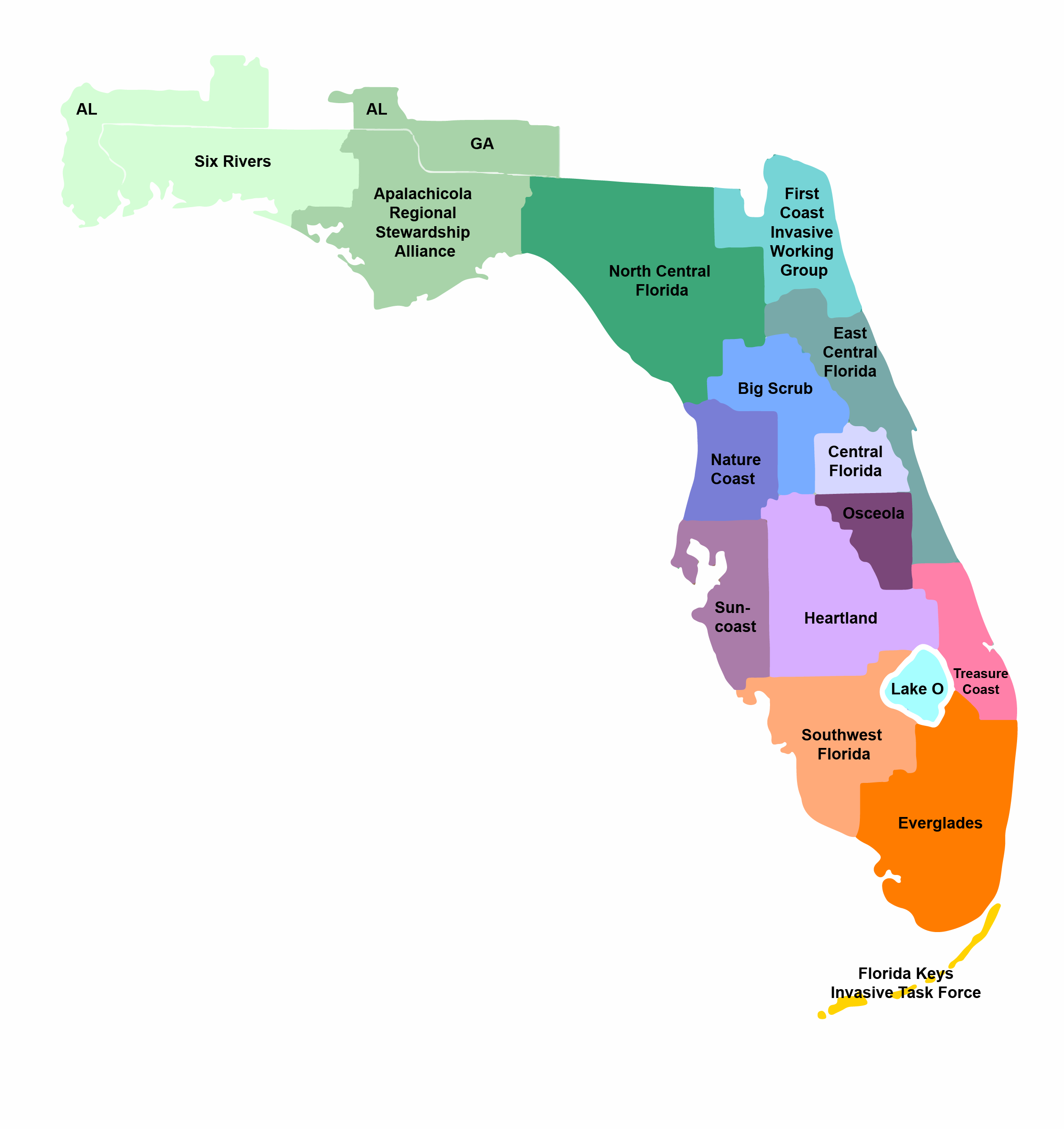
The Invasive Species Curve
Florida is certainly no stranger to invasive species. In fact, with our climate and international travel, we have some of the largest problems. The Burmese python is a well known, but we also have problems with lizards, frogs, snakes, fish, snails, insects, mussels, and a large variety of plants. The state is divided into 15 Cooperative Invasive Species Management Areas (CISMAs). Two of these – Six Rivers and the Apalachicola Regional Stewardship Alliance (ARSA) cover the panhandle. Members of these CISMAs (which includes UF IFAS Extension) conduct management and education projects on local invasive species within their areas and also have a EDRR list for that area. An EDRR list is the Early Detection Rapid Response – the ones to be on the look out for.
Over the next few days UF IFAS Extension Agents from across the panhandle will be posting articles about the larger threats in their counties. We will be posting these by county so that both decision makers and the general public will be able to see which species are of most concern in their region.
If you have questions about invasive species in your area, or how to manage them, you can contact your county extension office for help.
The Forest Landowner Academy is the first of its kind offered by the UF School of Forest, Fisheries, and Geomatics Sciences (SFFGS) on the UF/IFAS Extension Online Learning catalog. Forest Landowners, and others in need of forest management education, are encouraged to enroll to connect with SFFGS forest management experts and receive quality core educational content on forestry and multiple-use stewardship concepts!
The seven course modules cover a variety of topics including:
Understanding your forest resources
Developing your management plan
Timber management
Marketing forest products
Other forest enterprises such as pine straw and hunting leases
Wildlife management
Planning for the future
Each module include an assessment questionnaire where you can apply what you’ve learned to your land or situation and begin or continue planning and making contacts. In addition being better prepared and equipped to be good stewards of their forest resources, those completing the course will earn a University of Florida Certificate of Completion.
This course is relevant for Florida forest landowners and land managers, as well as those in the neighboring coastal plain regions of GA and AL. Participants will build on this course as they receive information and attend educational events offered by the Florida Land Steward Program and other partners in Florida and neighboring states.
In Part 1 of Reducing Health Advisories, we discussed how owners of septic systems could develop a management plan to reduce such health advisories. In Part 2 we look at another option for septic system owners – converting to the local sewer system.
You might begin by asking – “why would I want to do that?”. It’s a fair question. If my septic system is working properly, do I need to convert to sewer? But is it? Some septic systems were not placed in a good location, and the general maintenance you would follow could still lead to leaking fecal bacteria. You may find that to move such a system to a better location would be more costly than tying in with the local sewer system. You may find that no where on your property is a suitable location for a septic system and conversion is needed. There is also the possibility that you septic system needs major repairs due to misuse or age, and that a sewer conversion is a cheaper option. There are several reasons why it might be time to convert.
With increase housing development in the panhandle comes an opportunity to convert from septic to sewer systems.
Photo: UF IFAS
Yet, across the state there has been some resistance to converting. In 2020, a University of Florida research team conducted a social survey across the state to determine why many septic system owners were resistant to converting to a sewer system. The survey was sent to 1,604 Florida residents in September of 2020 hoping to get 500 responses – usable responses were obtained from 517 people (32%). The key findings were broken down into categories – explained below.
Knowledge. The average score on the knowledge assessment was 54.7% – suggesting that they had some understanding of septic to sewer conversion topics. 64.8% could identify a graphic of a septic system, but only 57.1% could do the same for a sewer system. 82.8% could state who was responsible for maintaining a septic system, but only 48% could state who was responsible for the sewer. Only 33.1% could correctly state how often a septic system needed to be pumped out. They only slightly agreed that they understood the steps (or the costs) of converting from septic to sewer.
Attitude. Respondents had only a slightly positive attitude towards septic to sewer conversion. Most saw it as more useful and doable, but were not sure whether it was easy or not, and most felt it was too expensive.
Benefits and Barriers. Most agreed that converting reduced the maintenance responsibility on the homeowner and freed property for other uses. They agreed less that it made them a better neighbor. The major barriers to converting were (a) availability to hook up, (b) upfront costs, (c) and having to pay a monthly sewer bill. There was also a lack of interest in doing so. Suggested barriers they do not see as a major problem included (a) the fear of large scale sewer spills, (b) and having time to think about doing the conversion.
Diffusion and Innovations. Most agreed that sewer systems were more advantageous than septic systems – that they cause less trouble for the homeowner. They also believed that converting to sewer was within their needs, values, and beliefs. They believed that all communities should convert to sewer and that it was the responsible thing to do. 1
The results of the above study suggest that most Floridians believe that IF conversion is available, it is the right thing to do. The primary reasons why they do not would include costs and having a monthly bill. Many also felt there was no interest in doing so. An interesting note here… in my community, there is a cost share program available for specific communities within the city limits. Despite assistance with costs, no one has responded asking to participate. This suggested that the monthly sewer bill and disinterest in the issue are still large barriers. Another thought is that even with cost sharing, their portion of the bill is still outside of their price range. In 2022 we attempted to have a focus group meeting with these communities to see which of the assumptions were correct – but there was little interest in participating in such a discussion group – so, we are not 100% sure why they do not participate.
All that said, conversion to a sewer system is an option for those on a septic system and there are benefits in doing so. As mentioned in the study, it takes much of the maintenance issues and concerns off of the property owner. Though properly maintained septic systems do a good job of treating fecal bacteria, sewer systems usually have three levels of treatment (sometimes more) decreasing the chance of health advisories. But they are not without their problems.
The survey suggested that Floridians are less aware of how their sewers work than a septic systems. In Part 3 we will look at how the sewer process operates. If you are a property owner with a septic system and interested in converting to sewer, contact your county health department to see how the process is done locally, and whether there is a cost share program.
1 Rampold, S. D., Krimsky, L., Telg, R. W., & Warner, L. (2021). Florida homeowners’ knowledge, perceptions, and informational needs regarding septic to sewer conversion. PIE2020/21-05. Gainesville, FL: University of Florida/IFAS Center for Public Issues Education.
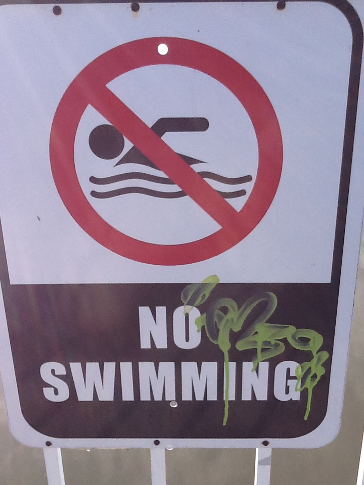
Health advisories are issued by state and local health departments when levels of fecal bacteria become too high for the public to safely enter the water. Sewage can be a source of these fecal bacteria. They can harbor pathogenic organisms that can cause of a variety of health problems. State and local health departments routinely monitor local waterways, particularly where people recreate, to assure the level of fecal bacteria is not unsafe. It is understood that the presence of fecal bacteria in waterways is normal, animals do go the bathroom, but excessive levels can be unsafe.
Closed due to bacteria.
Photo: Rick O’Connor
In the Pensacola Bay area, most of the human recreation areas near the barrier islands rarely have health advisories issued. Once every few years there is an issue at the sewage treatment facility on Pensacola Beach and an advisory is issued, or a sewage line is broken either near Santa Rosa Sound or Big Lagoon with the same results. But is very rare.
However, our local bayous are different. The neighborhoods are densely populated with old or outdated infrastructure, and how we manage these systems can cause problems as well. We are going to do a three-part series on what property owners can do to help reduce the number of health advisories issued in waterways where they are more common. In Part 1 we will look at how to maintain your septic system.
Septic systems were commonly used decades ago when city limits, and treatment facilities, were smaller. Many communities within our counties are on a septic system, and it falls on the property owner to properly maintain them.
Most understand how the system works, but for those who are not familiar – here are the basics.
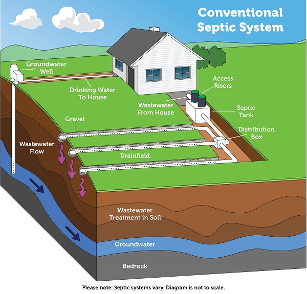
When you flush your commode, take a shower, or wash your clothes, the wastewater leaves your house through a series of pipes and empties into a septic tank buried in your yard. These tanks are usually made of concrete and there are different sizes. A typical tank will be about 8 feet long x 4 feet wide x 6 feet deep and hold around 1000 gallons (again, sizes vary). The solid material settles to the bottom where it is broken down by living microbes. The oils and fats float to the surface forming a scum layer. The remaining wastewater settles in the middle of the tank and drains into a drain field through a series of perforated pipes.
The drain field should be made of less compacted soils to allow percolation into the surrounding environment. There is some physical, chemical, and biological treatment of the wastewater as it percolates, but only if the drain field is properly designed and located. For obvious reasons you should not (and most communities will not allow) have your drain field next to an open or public water system. In Florida it is required that the loose uncompacted soils must be no less than 24 inches above the wet/water table.
A conventional septic system is composed of a septic tank and a drainfield, where most of the wastewater treatment takes place. Image: US EPA
It has been found that if the septic system is placed in the correct location and maintained properly, it does a good job of removing pathogens from the wastewater. However, it was not designed to remove nutrients, which can still leach into waterways and cause algal blooms. And the presence of pharmaceuticals and household chemicals are not always removed, which can cause problems for aquatic wildlife. But to reduce health advisories they can work.
So…
How do we maintain our septic system so that it functions properly?
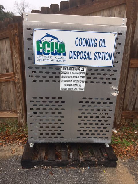
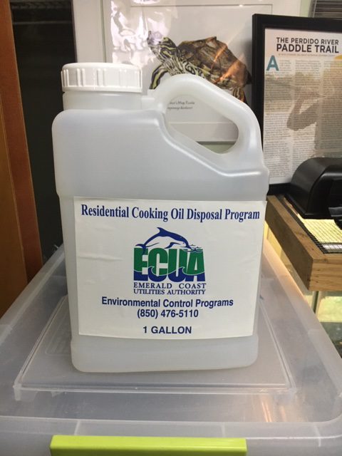
Watch what you pour down your drain. As mentioned above, many household chemicals and pharmaceuticals are not removed and become environmental problems when they leach from the drain fields into the local environment. Fats, oils, and grease (and even milk) can solidify and form the scum layer at the top of the septic tank. These solids can clog the lines running to the septic tank, or the drain field lines themselves. They can create back flows and could cause untreated sewage to back flow into your home. Our local utility offers the FOGProgram. In this program you can visit a local dispensing site (these can be found at ECUA’s website and there is one at the Escambia County Extension Office) to obtain as free 1-gallon plastic jug. Pour your bacon grease, oils, etc. into these containers. When full, return them to the dispensing location and swap out for a clean empty one. The service is free.
Watch how much water you use. As mentioned, septic tanks come in different sizes and are designed for a certain amount of water. “Flooding” of the system can occur if you are using more water than your system is designed for and this could include flooding of semi, or untreated, sewage.
The scum and solid layers of the tank need to be pumped out. It is recommended the septic systems are pumped once every 3-5 years, depending on the size of the tank. A pump out may cost you several hundreds of dollars, but a tank replacement is going to be in thousands – it is a good investment and will help reduce health advisories in local waterways.
Do not drive over your septic system, or drain field, with heavy vehicles. This could crack the tank and/or compact the soils within the drain field.
The FOG gallon containers are found in these metal cabinets placed around the county.
Photo: Rick O’Connor 1-gallon container provided free to dispose of your oil and grease.
Photo: Rick O’Connor
Studies have shown that a properly designed, properly placed, and properly maintained septic system will work well in reducing the presence of pathogenic fecal bacteria in our local waterways for up to 50 years. Note: like all things, even a good septic tank does have a live span. If you do not know the history of your septic system, we recommend you contact a certified professional to come do an assessment.
As always, if you have additional questions, do not hesitate to contact your county extension office.