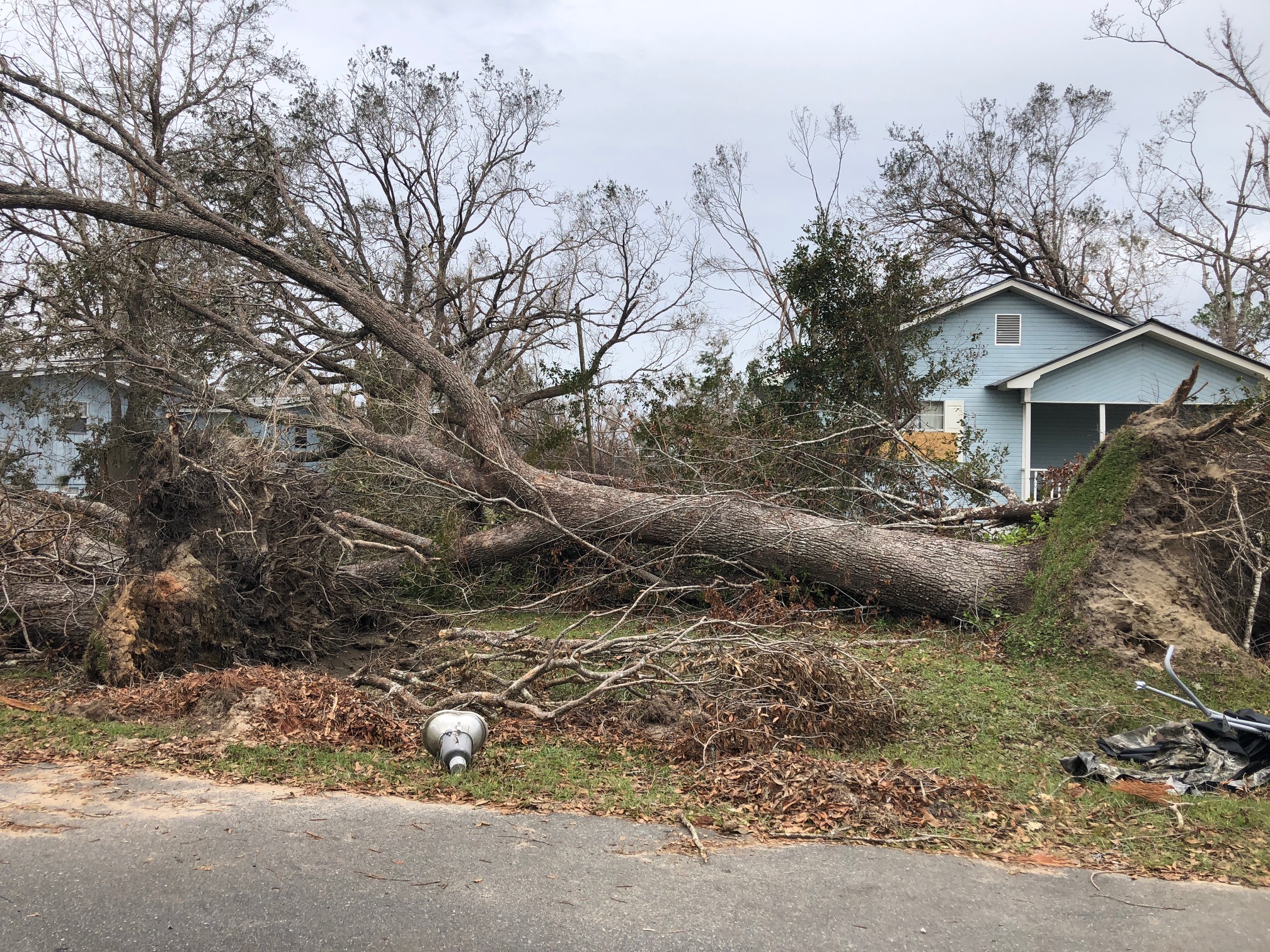
This tree was downed during Hurricane Michael, which made a late-season (October) landfall as a Category 5 hurricane. Photo credit: Carrie Stevenson, UF IFAS Extension
There are plenty of jokes about the four seasons in Florida—in place of spring, summer, fall, and winter; we have tourist, mosquito, hurricane, and football seasons. The weather and change in seasons are definitely different in a mostly-subtropical state, although we in north Florida do get our share of cold weather (remember that snow this year?!).
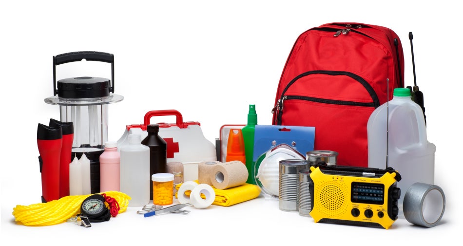
A disaster supply kit contains everything your family might need to survive without power and water for several days. Photo credit: Weather Underground
All jokes aside, hurricane season is a real issue in our state. With the official season having recently begun (June 1) and running through November 30, hurricanes in the Gulf-Atlantic region are a legitimate concern for fully half the calendar year. According to records kept since the 1850’s, Florida has been hit with more than 120 hurricanes, double that of the closest high-frequency target, Texas. Hurricanes can affect areas more than 50 miles inland, meaning there is essentially no place to hide in our long, skinny, peninsular state.
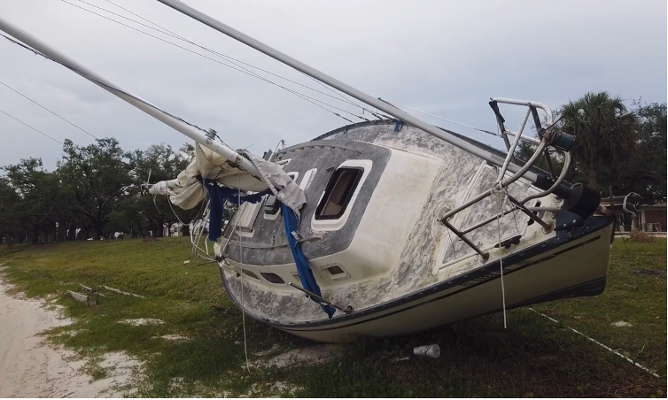
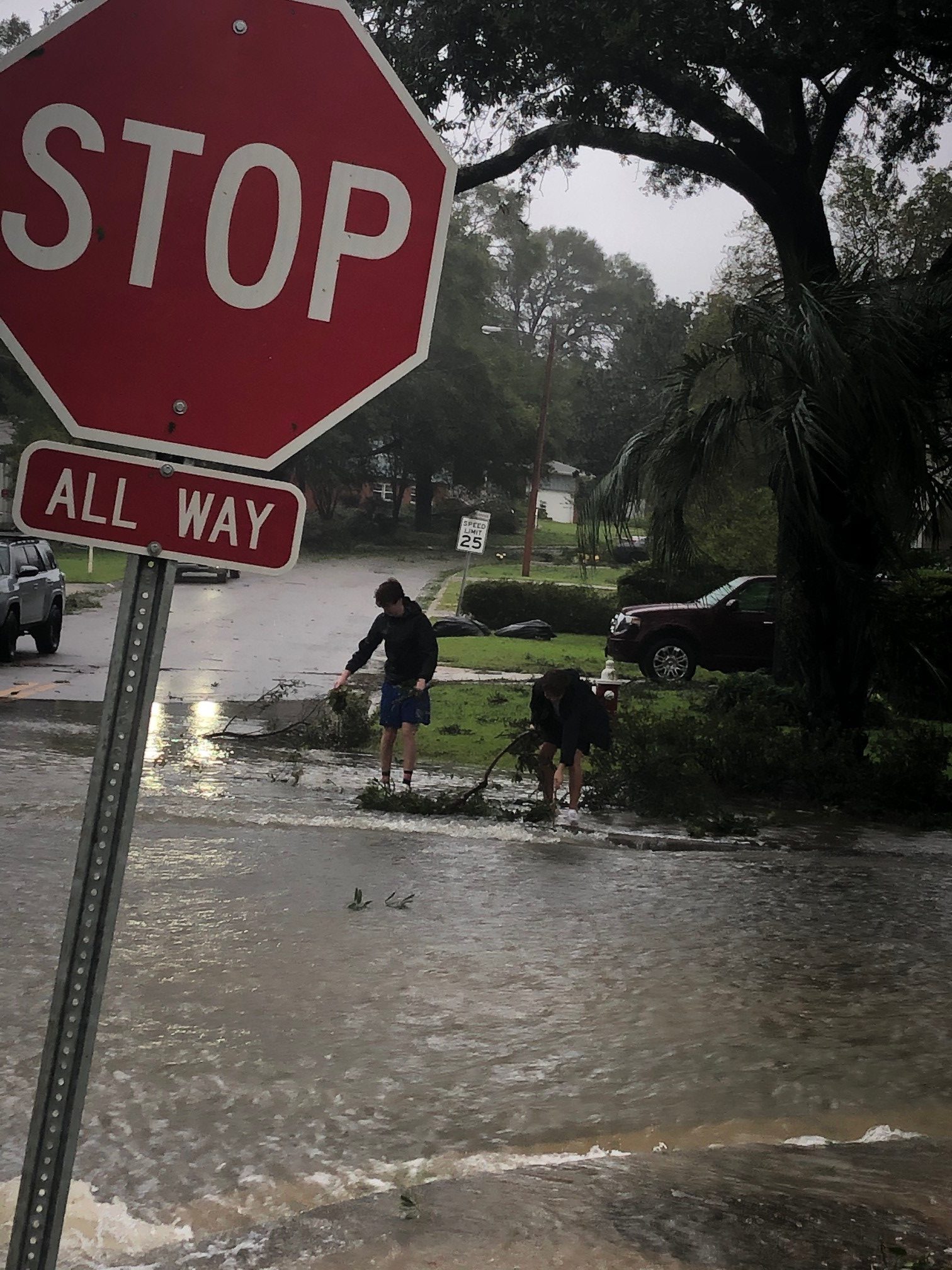
Flooding and storm surge are the most dangerous aspects of a hurricane. Photo credit: Carrie Stevenson, UF IFAS Extension
I point all these things out not to cause anxiety, but to remind readers (and especially new Florida residents) that is it imperative to be prepared for hurricane season. Just like picking up pens, notebooks, and new clothes at the start of the school year, it’s important to prepare for hurricane season by firing up (or purchasing) a generator, creating a disaster kit, and making an evacuation plan. We even have disaster preparedness sales tax exempt holidays in Florida; one in early June and another in the heart of the season, August 24-September 6.
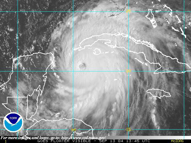
Peak season for hurricanes is September. Particularly for those in the far western Panhandle, September 16 seems to be our target—Hurricane Ivan hit us on that date in 2004, and Sally made landfall exactly 16 years later, in 2020. But if the season starts in June, why is September so intense? By late August, the Gulf and Atlantic waters have been absorbing summer temperatures for 3 months. The water is as warm as it will be all year–in 2023 even reaching over 100 degrees Fahrenheit–as ambient air temperatures hit their peak. This warm water is hurricane fuel—it is a source of heat energy that generates power for the storm. Tropical storms will form early and late in the season, but the highest frequency (and often the strongest ones) are mid-August through late September.
Pay attention to local meteorologists on social media, news, and radio. This alert was posted just yesterday online by the Escambia County Emergency Management Coordinator.
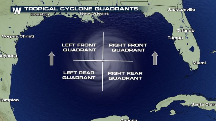
If you have lived in a hurricane-prone area, you know you don’t want to be on the front right side of the storm. For example, here in Pensacola, if a storm lands in western Mobile or Gulf Shores, Alabama, the impact will nail us. Meteorologists divide hurricanes up into quadrants around the center eye. Because hurricanes spin counterclockwise but move forward, the right front quadrant will take the biggest hit from the storm. A community 20 miles away but on the opposite side of a hurricane may experience little to no damage.
The front right quadrant of a hurricane is the strongest portion of a storm. Photo credit: Weather Nation
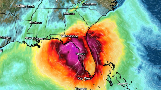
Hurricanes bring with them high winds, heavy rains, and storm surge. Of all those concerns, storm surge is the deadliest, accounting for about half the deaths associated with hurricanes in the past 50 years. Many waterfront residents are taken by surprise at the rapid increase in water level due to surge and wait until too late to evacuate. Storm surge is caused by the pressure of the incoming hurricane building up and pushing the surrounding water inland. Storm surge for Hurricane Katrina was 30 feet above normal sea level, causing devastating floods throughout coastal Louisiana and Mississippi. Due to the dangerous nature of storm surge, NOAA and the National Weather Service have begun announcing storm surge warnings along with hurricane and tornado warnings.
Coastal wetlands are some of the most ecologically productive environments on Earth. They support diverse plant and animal species, provide essential ecosystem services such as stormwater filtration, and act as buffers against storms. As Helene showed the Big Bend area, storm surge is devastating to these delicate ecosystems.
Hurricane Track on Wednesday evening.
As the force of rushing water erodes soil, uproots vegetation, and reshapes the landscape, critical habitats for wildlife, in and out of the water, is lost, sometimes, forever. Saltwater is forced into the freshwater wetlands. Many plants and aquatic animal species are not adapted to high salinity, and will die off. The ecosystem’s species composition can completely change in just a few short hours.
Prolonged storm surge can overwhelm even the very salt tolerant species. While wetlands are naturally adept at absorbing excess water, the salinity concentration change can lead to complete changes in soil chemistry, sediment build-up, and water oxygen levels. The biodiversity of plant and animal species will change in favor of marine species, versus freshwater species.
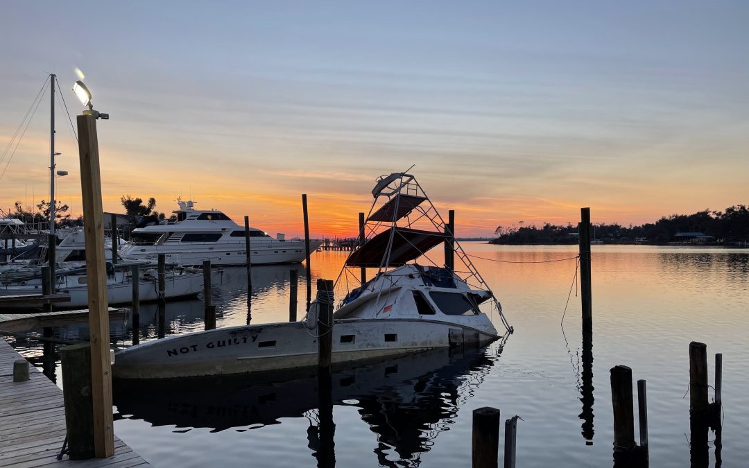
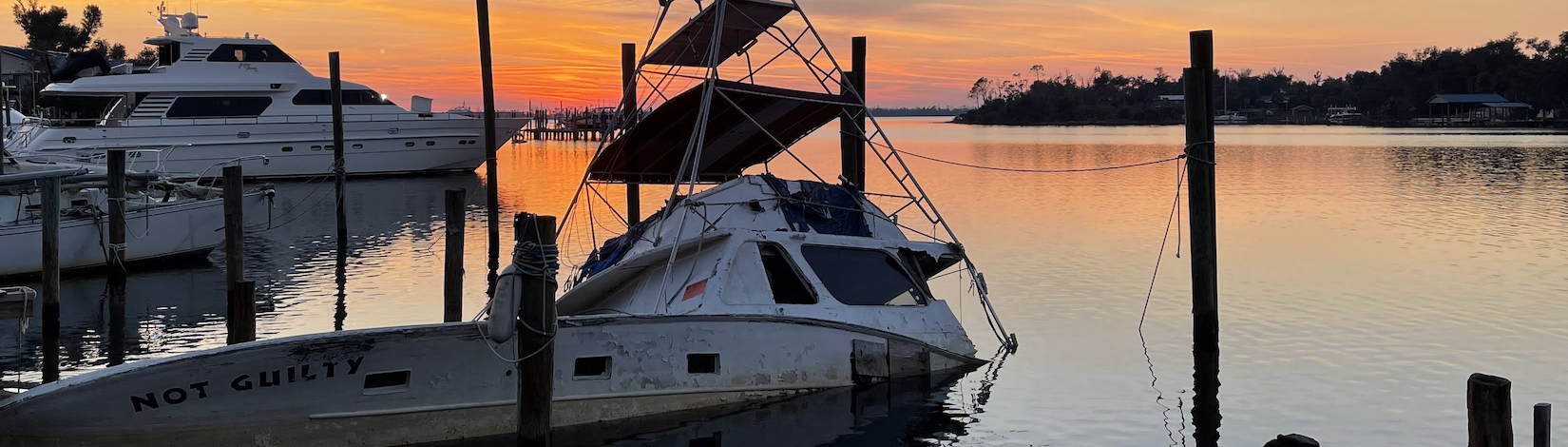
Coastal communities impacted by a hurricane change the view of the landscape for months, or even, years. Construction can replace many of the structures lost. Rebuilding wetlands can take hundreds of years. In the meantime, these developments remain even more vulnerable to the effects of the next storm. Apalachicola and Cedar Key are examples of the impacts of storm surge on coastal wetlands. Helene will do even more damage.
Many of the coastal cities in the Big Bend have been implementing mitigation strategies to reduce the damage. Extension agents throughout the area have utilized integrated approaches that combine natural and engineered solutions. Green Stormwater Infrastructure techniques and Living Shorelines are just two approaches being taken.
So, as we all wish them a speedy recovery, take some time to educate yourself on what could be done in all of our Panhandle coastal communities to protect our fragile wetland ecosystems. For more information go to:
This tree was downed during Hurricane Michael, which made a late-season (October) landfall as a Category 5 hurricane. Photo credit: Carrie Stevenson, UF IFAS Extension
There are a lot of jokes out there about the four seasons in Florida—instead of spring, summer, fall, and winter; we have tourist, mosquito, hurricane, and football seasons. The weather and change in seasons are definitely different in a mostly-subtropical state, although we in north Florida do get our share of cold weather (particularly in January!).
All jokes aside, hurricane season is a real issue in our state. With the official season about to begin (June 1) and running through November 30, hurricanes in the Gulf-Atlantic region are a legitimate concern for fully half the calendar year. According to records kept since the 1850’s, our lovely state has been hit with more than 120 hurricanes, double that of the closest high-frequency target, Texas. Hurricanes can affect areas more than 50 miles inland, meaning there is essentially no place to hide in our long, skinny, peninsular state.
A disaster supply kit contains everything your family might need to survive without power and water for several days. Photo credit: Weather Underground
I point all these things out not to cause anxiety, but to remind readers (and especially new Florida residents) that is it imperative to be prepared for hurricane season. Just like picking up pens, notebooks, and new clothes at the start of the school year, it’s important to prepare for hurricane season by firing up (or purchasing) a generator, creating a disaster kit, and making an evacuation plan.
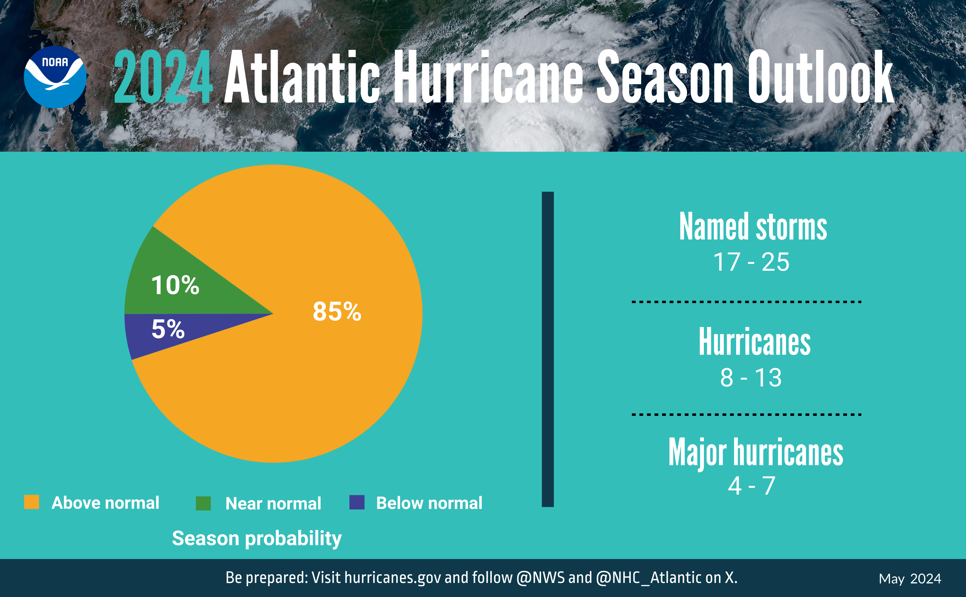
A summary infographic showing hurricane season probability and numbers of named storms predicted from NOAA’s 2024 Atlantic Hurricane Season Outlook. (Spanish version) (Image credit: NOAA)
Peak season for hurricanes is September. Particularly for those in the far western Panhandle, September 16 seems to be our target—Hurricane Ivan hit us on that date in 2004, and Sally made landfall exactly 16 years later, in 2020. But if the season starts in June, why is September so intense? By late August, the Gulf and Atlantic waters have been absorbing summer temperatures for 3 months. The water is as warm as it will be all year, as ambient air temperatures hit their peak. This warm water is hurricane fuel—it is a source of heat energy that generates power for the storm. Tropical storms will form early and late in the season, but the highest frequency (and often the strongest ones) are mid-August through late September. We are potentially in for a doozy of a season this year, too–NOAA forecasters are predicting a very active season, including up to 25 named storms. According to a recent article from Yale Climate Connections, Gulf waters are hotter this May than any year since oceanographers started measuring it in 1981.
The front right quadrant of a hurricane is the strongest portion of a storm. Photo credit: Weather Nation
If you have lived in a hurricane-prone area, you know you don’t want to be on the front right side of the storm. For example, here in Pensacola, if a storm lands in western Mobile or Gulf Shores, Alabama, the impact will nail us. Meteorologists divide hurricanes up into quadrants around the center eye. Because hurricanes spin counterclockwise but move forward, the right front quadrant will take the biggest hit from the storm. A community 20 miles away but on the opposite side of a hurricane may experience little to no damage.
Flooding and storm surge are the most dangerous aspects of a hurricane. Photo credit: Carrie Stevenson, UF IFAS Extension
Hurricanes bring with them high winds, heavy rains, and storm surge. Of all those concerns, storm surge is the deadliest, accounting for about half the deaths associated with hurricanes in the past 50 years. Many waterfront residents are taken by surprise at the rapid increase in water level due to surge and wait until too late to evacuate. Storm surge is caused by the pressure of the incoming hurricane building up and pushing the surrounding water inland. Storm surge for Hurricane Katrina was 30 feet above normal sea level, causing devastating floods throughout coastal Louisiana and Mississippi. Due to the dangerous nature of storm surge, NOAA and the National Weather Service have begun announcing storm surge warnings along with hurricane and tornado warnings.
Call 811 before you dig. No one wants a weekend project to be the cause of Internet, phone and cable outages. Worse yet, what if someone gets hurt from contact with natural gas or electrical lines? That’s why it is so important to have buried utilities in the yard located and marked before digging. Sunshine 811 coordinates each individual company to clearly mark where the service lines are located. Homeowners are required by law to contact 811 three days before any soil removal is done. The service is free.
Have information prepared before making the request. Describe the work to be performed (e.g. fence install, landscaping, irrigation install), including the type of equipment that will be used. Specify the exact location on the property and how long the work will continue. Finally, provide all the contact information (e.g. name, phone number, e-mail), should there be any additional questions.
Call 811 or request a single address ticket online. Receive a ticket number and wait two full business days, not counting weekends or holidays. Then contact 811 again. Make sure that all the utilities have responded in the Positive Response System (PRS). Sometimes that may mean that the company doesn’t have anything to make in the area.
If there are utility lines running through the yard, they will be marked with specifically colored paints or flags. Red is used for electrical lines, orange indicates communication lines, yellow means gas, blue is used for potable water, purple is reclaimed water, and green indicates sewer lines. White lines may be used to outline digging areas and pink are temporary survey marks. This is the APWA Uniform Color Code.
Every effort is made to locate the lines as accurately as possible. But, the safest thing to do is hand dig to expose the utility line before using any mechanized equipment. Lines can vary up to 24” from the marked line and depths can be less than 5”. Remember there may be access lines running through the property even if that service isn’t utilized at that address.
Organized and sponsored by Florida Sea Grant, the “Stem to Stern” workshop in November 2023 at the Emerald Coast Convention Center marked a significant gathering in marine conservation and management. This event drew together legal experts, representatives from the Florida Fish and Wildlife Conservation Commission (FWC), local marine resource coordinators, law enforcement, and industry stakeholders to tackle critical issues facing Florida’s marine environments. Through discussions that ranged from legal frameworks for boating and waterway access to environmental conservation strategies, the workshop facilitated a deep dive into the complexities of marine policy and stewardship. Discover new programs, insights, and collective expertise shared at “Stem to Stern.”
Florida Sea Grant Boating and Waterways Workshop
November 2, 2023 Emerald Coast Convention Center
1250 Miracle Strip Parkway SE – Ft. Walton Beach FL
9:00 – 9:25 WELCOME AND INTRODUCTIONS
Welcome
Rick O’Connor (Florida Sea Grant UF IFAS Extension)
Moderators –Mike Norberg and Jessica Valek (Okaloosa County)
3:15 – 3:45 WRAP UP – Robert Turpin (Escambia County Marine Resources)
PROGRAM SPONSORS
Acknowledgement
We extend our deepest gratitude to all who contributed to the success of the “Stem to Stern” workshop. To our esteemed speakers, whose expertise and insights into marine conservation and management have been invaluable, we offer our sincere thanks. Your presentations were not only informative but also inspirational, guiding us toward a more sustainable future for our waterways.
A special acknowledgment goes to the members of the planning and program committee. Your dedication and hard work in organizing this event did not go unnoticed. From the initial planning stages to the execution of the workshop, your efforts have been the backbone of this successful gathering.
We also want to thank the authors of the surveys that have provided us with essential data and perspectives. Your research and analysis contribute significantly to our understanding of the challenges and opportunities within Florida boating and waterways.
Lastly, we are incredibly grateful for the support from our sponsors. Your generosity and commitment to Florida Sea Grant and marine conservation have been crucial in bringing this workshop to life. Your support not only made this event possible but also highlights your dedication to safeguarding our marine ecosystems.
Together, we have taken an important step towards protecting and enhancing Florida’s waterways. Thank you for your contributions, commitment, and shared vision for a sustainable future.
Information edited and compiled by: L. Scott Jackson, Chantille Weber, and Amon Philyaw, UF/IFAS Extension Bay County
An Equal Opportunity Institution. UF/IFAS Extension, University of Florida, Institute of Food and Agricultural Sciences, Andra Johnson, Dean. Single copies of UF/IFAS Extension publications (excluding 4-H and youth publications) are available free to Florida residents from county UF/IFAS Extension offices.
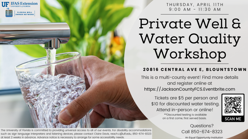
Join us for our upcoming multi-county private well and water quality workshop. As a private well user, you are responsible for ensuring that your water is safe to drink. We will cover how private wells and septic systems work, proper maintenance, steps to help ensure your drinking water is safe to consume and disaster preparedness for this upcoming hurricane season. We will also offer facilitated water testing for bacteria, lead and nitrate.
The workshop will be offered on Thursday, April 11, 2024, from 9:00 am – 11:30 am CST at the Calhoun County Extension Offices, 20816 Central Ave. E, Blountstown. You can also attend virtually via Zoom. Registration is $5.00 per person. Facilitated water screening for total coliform and E. coli bacteria is available at a reduced cost. Please register on Eventbrite, https://JacksonCountyFCS.Eventbrite.com/ or you can also register by visiting the Calhoun County Extension Office, (850-674-8323). This workshop is being presented by UF/IFAS Extension Bay, Calhoun, Holmes, Jackson, and Washington Counties.
For lead and nitrate testing prices and additional details, visit our Eventbrite page or call the Calhoun County Extension Office at 850-674-8323. Pre-registration is encouraged as seating is limited, but as mentioned previously, a virtual option is also available. For persons with disabilities requiring special accommodations, please contact the Extension Office (TDD, via Florida Relay Service, 1-800-955-8771) at least ten working days prior to the class so that proper consideration may be given to the request. UF/IFAS Extension is an Equal Opportunity Institution.