
by Sheila Dunning | Jan 19, 2018
The Florida Master Naturalist Program is an adult education University of Florida/IFAS Extension program. Training will benefit persons interested in learning more about Florida’s environment or wishing to increase their knowledge for use in education programs as volunteers, employees, ecotourism guides, and others.
Through classroom, field trip, and practical experience, each module provides instruction on the general ecology, habitats, vegetation types, wildlife, and conservation issues of Coastal, Freshwater and Upland systems. Additional special topics focus on Conservation Science, Environmental Interpretation, Habitat Evaluation, Wildlife Monitoring and Coastal Restoration. For more information go to: http://www.masternaturalist.ifas.ufl.edu/ Okaloosa and Walton Counties will be offering Upland Systems on Thursdays from February 15- March 22. Topics discussed include Hardwood Forests, Pinelands, Scrub, Dry Prairie, Rangelands and Urban Green Spaces. The program also addresses society’s role in uplands, develops naturalist interpretation skills, and discusses environmental ethics. Check the website for a Course Offering near you :http://conference.ifas.ufl.edu/fmnp/
by Sheila Dunning | Jan 19, 2018
We plant trees with the intention of them being there long after we are gone. However, many trees and shrubs fail before ever reaching maturity. Often this is due to improper installation and establishment. Research has shown that there are techniques to improve survivability. Before digging the hole:
- Look up. If there is a wire, security light, or building nearby that could interfere with proper development as it grows, plant elsewhere.
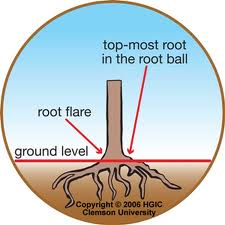
- Dig a shallow planting hole as wide as possible. Shallow is better than deep! Many people plant trees too deep. A hole about one-and-one-half the diameter of the width of the root ball is recommended. Wider holes should be used for compacted soil and wet sites. In most instances, the depth of the hole should be LESS than the height of the root ball, especially in compacted or wet soil. If the hole was inadvertently dug too deep, add soil and compact it firmly with your foot. .
- Find the point where the top-most root emerges from the trunk. If this is buried in the root ball then remove enough soil from the top so the point where the top-most root emerges from the trunk is at the surface. Burlap on top of the ball may have to be removed to locate the top root.
- Slide the plant carefully into the planting hole. To avoid damage when setting a large tree in the hole, lift the tree with straps or rope around the root ball, not by the trunk. Special strapping mechanisms need to be constructed to carefully lift trees out of large containers.
- Position the plant where the top-most root emerges from the trunk slightly above the landscape soil surface. It is better to plant a little high than to plant it too deep. Remove most of the soil and roots from on top of the root flare and any growing around the trunk or circling the root ball. Once the root flare is at the appropriate depth, pack soil around the root ball to stabilize it. Soil amendments are usually of no benefit. The soil removed from the hole and from on top of the root ball makes the best backfill unless the soil is terrible or contaminated. Insert a square-tipped balling shovel into the root ball tangent to the trunk to remove the entire outside periphery. This removes all circling and descending roots on the outside edge of the root ball.
- Straighten the plant in the hole. Before you begin backfilling have someone view the plant from two directions perpendicular to each other to confirm that it is straight. Break up compacted soil in a large area around the plant provides the newly emerging roots room to expand into loose soil. This will hasten root growth translating into quicker establishment Fill in with some more backfill soil to secure the plant in the upright position.
- Remove synthetic materials from around trunk and root ball. Synthetic burlap needs to be completely removed from the root ball; treated burlap can be left in place. String, strapping, plastic, and other materials that will not decompose and must be removed from the trunk at planting. Remove the wire above the soil surface from wire baskets before backfilling.
- Apply a 3-inch-layer of mulch. To retain moisture and suppress weeds cover the outer half of the root ball with an organic mulch. Do not cover the stem of the plant or the connecting root flare.
- Water consistently until established. For nursery stock less than 2-inches in caliper, this will require every other day for 2 months, followed by weekly 3-4 months. At each irrigation, apply 2 to 3 gallons of water per inch trunk caliper directly over the root ball. Never add irrigation if the ground is saturated.
by Sheila Dunning | Dec 15, 2017
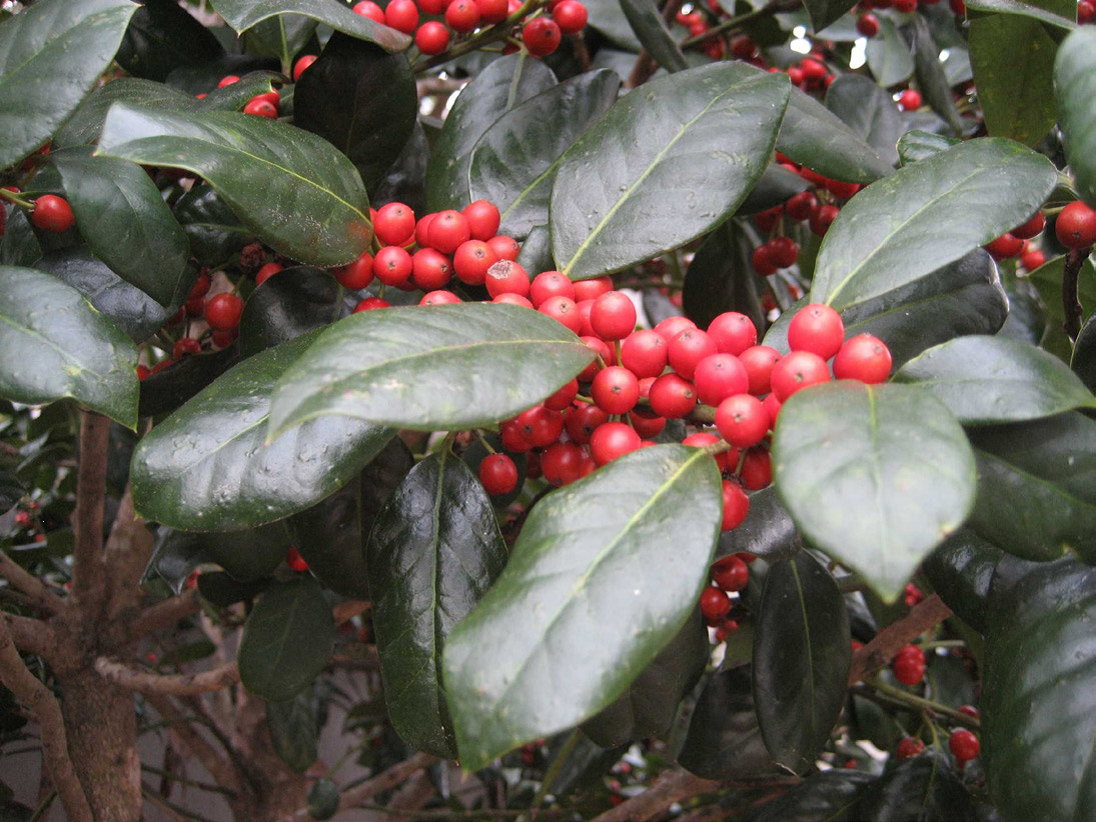
According to Druid lore, hanging the plant in homes would bring good luck and protection. Holly was considered sacred because it remained green and strong with brightly colored red berries no matter how harsh the winter. Most other plants would wilt and die.
 Later, Christians adopted the holly tradition from Druid practices and developed symbolism to reflect Christian beliefs. Today, the red berries are said to represent the blood that Jesus shed on the cross when he was crucified. Additionally, the pointed leaves of the holly symbolize the crown of thorns Jesus wore on his head.
Several hollies are native to Florida. Many more are cultivated varieties commonly used as landscape plants. Hollies (Ilex spp.) are generally low maintenance plants that come in a diversity of sizes, forms and textures, ranging from large trees to dwarf shrubs.
The berries provide a valuable winter food source for migratory birds. However, the berries only form on female plants. Hollies are dioecious plants, meaning male and female flowers are located on separate plants. Both male and female hollies produce small white blooms in the spring. Bees are the primary pollinators, carrying pollen from the male hollies 1.5 to 2 miles, so it is not necessary to have a male plant in the same landscape.
Several male hollies are grown for their compact formal shape and interesting new foliage color. Dwarf Yaupon Hollies (Ilex vomitoria ‘Shillings’ and ‘Bordeaux’) form symmetrical spheres without extensive pruning. ‘Bordeaux’ Yaupon has maroon-colored new growth. Neither cultivar has berries.
Hollies prefer to grow in partial shade but will do well in full sun if provided adequate irrigation. Most species prefer well-drained, slightly acidic soils. However, Dahoon holly (Ilex cassine) and Gallberry (Ilex glabra) naturally occurs in wetland areas and can be planted on wetter sites.
Evergreen trees retain leaves throughout the year and provide wind protection. The choice of one type of holly or another will largely depend on prevailing environmental conditions and windbreak purposes. If, for example, winds associated with storms or natural climatic variability occur in winter, then a larger leaved plant might be required.
The natives are likely to be better adapted to local climate, soil, pest and disease conditions and over a broader range of conditions. Nevertheless, non-natives may be desirable for many attributes such as height, growth rate and texture but should not reproduce and spread beyond the area planted or they may become problematic because of invasiveness.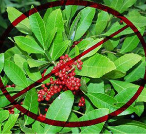
There is increasing awareness of invasiveness, i.e., the potential for an introduced species to establish itself or become “naturalized” in an ecological community and even become a dominant plant that replaces native species. Tree and shrub species can become invasive if they aggressively proliferate beyond the windbreak. At first glance, Brazilian pepper (Schinus terebinthifolius), a fast-growing, non-native shrub that has a dense crown, might be considered an appropriate red berry producing species. However, it readily spreads seed disbursed by birds and has invaded many natural ecosystems. Therefore, the Florida Department of Environmental Protection has declared it illegal to plant this tree in Florida without a special permit. Consult the Florida Exotic Pest Plant Council’s Web page (www.fleppc.org) for a list of prohibited species in Florida.
For a more comprehensive list of holly varieties and their individual growth habits refer to ENH42 Hollies at a Glance: http://edis.ifas.ufl.edu/mg021
by Laura Tiu | Nov 20, 2017
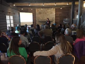
The lodge at Camp Helen State Park was the perfect backdrop for the Coastal Dune Lake Seminar Series Water School. Brandy Foley of the Choctawhatchee Basin Alliance shares her paleolimnology research work on the lakes.
On a beautiful October day, 35 people gathered at the Camp Helen State Park lodge to share information about the rare Coastal Dune Lakes (CDLs) that line the coast of Walton and Bay Counties. Organized by the University of Florida Extension Programs in Bay and Walton counties, the Water School included a morning seminar series featuring speakers from various groups that work together to support the lakes. Laura Tiu, Sea Grant Agent for Walton and Okaloosa counties started off the day giving a broad overview of the history and ecology of the lakes. Brandy Foley of the Choctawhatchee Basin Alliance shared her research on the paleolimnology, or study of the lake sediments over time, of two coastal dune lakes. Clayton Iron Wolf, a ranger at Camp Helen, gave a summary of the importance of Lake Powell and its benefit to the park. Jeff Talbert of the Atlanta Botanical Garden thrilled attendees with his pictures and research on the Deer Lake State Park restoration project. Norm Capra, who wears many hats, including that of the Lake Powell Community Alliance and Friends of Camp Helen State Park, shared the work they have done promoting conservation of shorebirds there. Dr. Dana Stephens, Director of the Mattie Kelly Environmental Institute at Northwest Florida State College shared analyses of many years of water chemistry and quality data collected on the lakes. Melinda Gates, Environmental Specialist for Walton County, wrapped up with a presentation on the efforts to protect and preserve the lakes.
The attendees seemed pleased with the event with one hundred percent of attendees rating the quality of information presented, usefulness of information, speakers’ knowledge, overall value of the program, and quality of location as good or excellent. The seminar helped attendees identify important roles of the CDLs in the ecosystem and understand why it is important to protect them. Several participants plan to make behavior changes based in the workshop including: joining or volunteering with Choctawhatchee Basin Alliance, Audubon, Sierra Club or Lake Watch Volunteers; sharing the information; living minimally; and engaging in activism. The seminar was followed by a kayak tour lead by Scott Jackson, Bay County Sea Grant Agent, to the outflow of Lake Powell and a visit to a faux sea turtle nest demonstration by Florida Fish and Wildlife Commission. This Water School was part of a regional series offered by UF/IFAS Extension. For more information on future schools, please subscribe to our Panhandle Outdoors Newsletter.
by Rick O'Connor | Aug 11, 2017
Our first POL program will happen this week – August 17 – at the Navarre Beach snorkel reef, and is sold out! We are glad you all are interested in these programs.
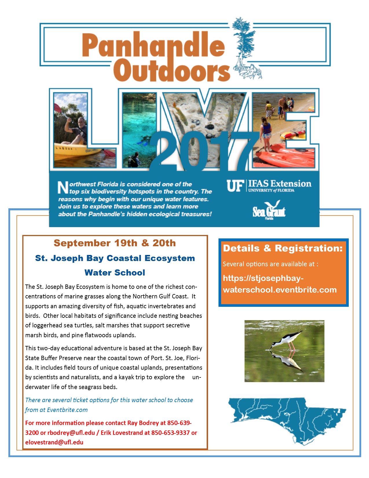
Well! We have another one for you. The Natural Resource Extension Agents from UF IFAS Extension will be holding a two-day water school at St. Joseph Bay. Participants will learn all about the coastal ecosystems surrounding St. Joe Bay in the classroom, snorkeling, and kayaking. Kayaks and overnight accommodations are available for those interested. This water school will be September 19-20. For more information contact Extension Agent Ray Bodrey in Gulf County or Erik Lovestrand in Franklin. Information and registration can be found at https://stjosephbay-waterschool.eventbrite.com.
by Chris Verlinde | Jul 29, 2017
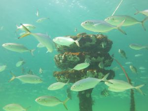
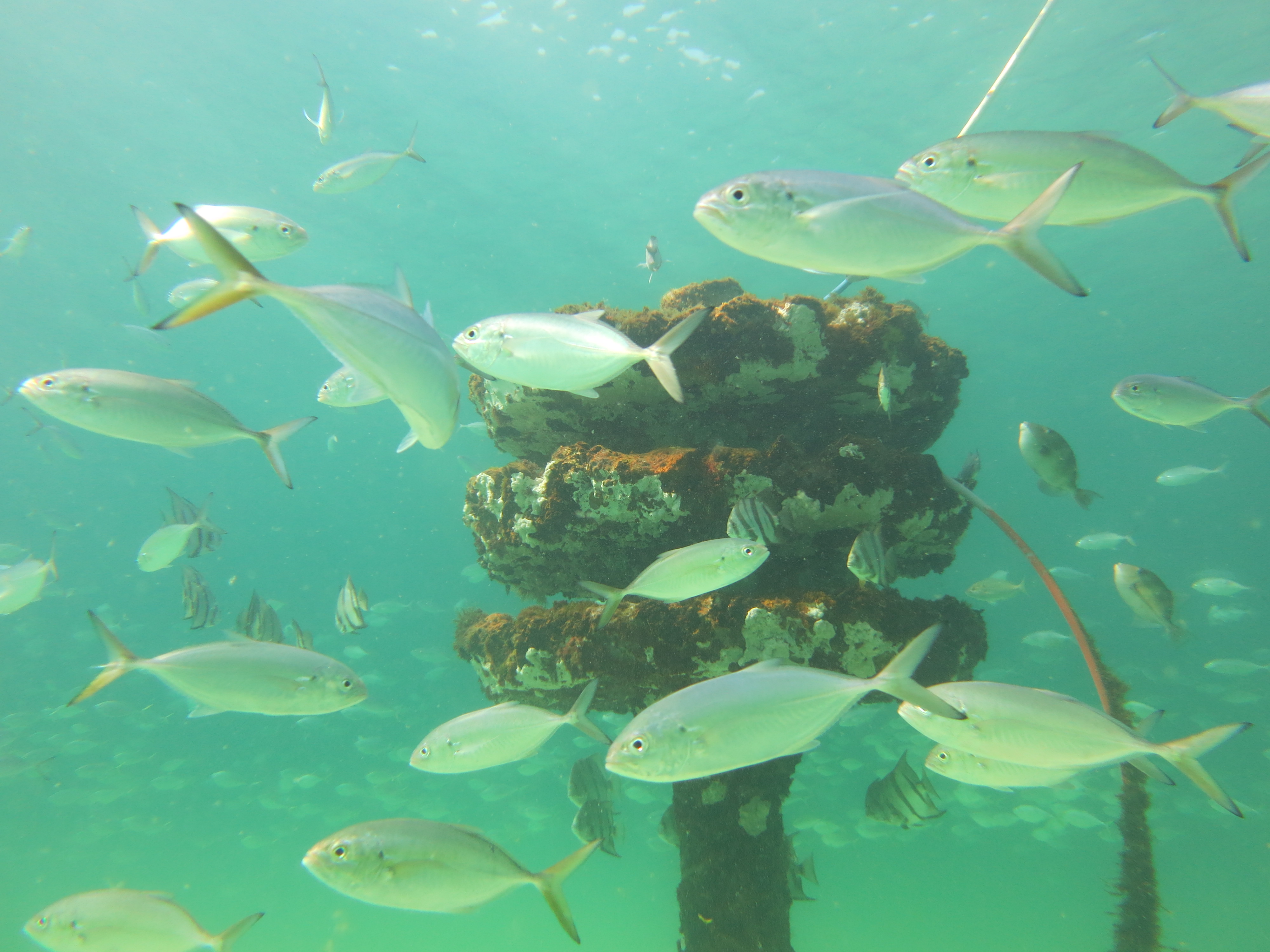
Photo Credit: Mike Sandler
Join the UF/IFAS Natural Resource Extension Agents as we explore the Navarre Beach Marine Sanctuary.
Thursday, August 17, 2017 from 9 am until 1 pm.
Register today at: https://nbsnorkel.eventbrite.com
The Navarre Beach Marine Sanctuary consists of 30 reef structures in the Gulf of Mexico. The whole site is as large as a football field. Reefs are located in 6 to 15 feet of water.
Participants will enjoy a brief introduction about the history of the reefs and economic impacts for the community. We will then head out to snorkel the reefs and observe the wildlife that can found in the area.
Participants will be expected to swim at least 375 feet to access the site and be experienced swimmers/snorkelers. Participants may see marine life such as: sea turtles, octopi and many fish species that inhabit the reef. Participants will need to bring a mask, snorkel and fins, flotation device such as a boogie board or a buoyancy compensator vest, sunscreen, etc. Cost is $20.00, lunch is included.
We will meet at the Sea Oat Pavilion which is at the second Gulf side parking lot in the NB Marine Park. There are picnic tables, restrooms, changing area and shower at the Pavilion.
This adventure is weather dependent, refunds (minus the Eventbrite fee) will be provided if we have to cancel due to inclement weather conditions or poor water visibility. If you have questions, please contact Chris Verlinde, 850-623-3868 or chrismv@ufl.edu.


